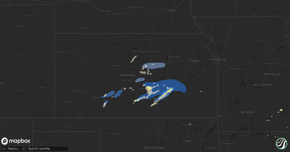
Hail Map in Kansas on September 20, 2024
Get this storm
September 20 map
$229
one time, instant access
Download today. No call, no setup
Keep the $229
Bought the map and want the full workflow? Apply the entire $229 to a subscription within 7 days. None of it is wasted.
Every map, not just this one
This buys you this map. Subscription and you get every map we run, in the markets you choose from a few cities to whole states to nationwide. Plus real-time alerts the moment a storm fires.
Contact data
Name, contact info, occupancy, even credit band for addresses in the footprint. You go from where it hit to who to call.
Become the source they trust
Unlimited branding weather history reports on demand. You already have the documented answer ready for the property owner, and you are the one who showed up with it.
Property data and RoofTrace estimates
Pull up any address you have got, its value and the exact code rules for that jurisdiction, straight from One Click Code. Then RoofTrace estimates the squares, pitch, and roof value, priced the way you price.
Storm reports in Kansas
Kansas
| Date | Description |
|---|---|
| 09/20/20246:50 PM CDT | A local report indicates 64 MPH wind near 1 WSW PRETTY PRAIRIE |
| 09/20/20246:50 PM CDT | A local report indicates 64 MPH wind near 1 WSW Pretty Prairie |
| 09/20/20246:49 PM CDT | A local report indicates 70 MPH wind near 3 W INMAN |
| 09/20/20246:49 PM CDT | A local report indicates 70 MPH wind near 3 W Inman |
| 09/20/20246:49 PM CDT | Public report via mping of 3-inch tree limbs broken and power poles broken. Time matched to previous report. |
| 09/20/20246:49 PM CDT | Public report via mping of 3-inch tree limbs broken and power poles broken. Time matched to previous report. |
| 09/20/20246:44 PM CDT | Trained spotter estimates 60 to 65 mph. An empty tank was blown off a trailer. |
| 09/20/20246:44 PM CDT | Trained spotter estimates 60 to 65 mph. An empty tank was blown off a trailer. |
| 09/20/20246:43 PM CDT | Semi blew over on interstate 70 near mile marker 239. Time is estimated from radar. |
| 09/20/20246:43 PM CDT | Semi blew over on interstate 70 near mile marker 239. Time is estimated from radar. |
| 09/20/20246:39 PM CDT | A local report indicates 60 MPH wind near 6 WSW GLENDALE |
| 09/20/20246:39 PM CDT | A local report indicates 60 MPH wind near 6 WSW Glendale |
| 09/20/20246:38 PM CDT | A local report indicates 65 MPH wind near 1 N Kingman |
| 09/20/20246:38 PM CDT | A local report indicates 65 MPH wind near 1 N KINGMAN |
| 09/20/20246:20 PM CDT | A local report indicates 69 MPH wind near 2 W LITTLE RIVER |
| 09/20/20246:20 PM CDT | A local report indicates 69 MPH wind near 2 W Little River |
| 09/20/20245:49 PM CDT | A u-haul trailer was reported to have blown over on the west side of lyons. Time estimated from radar. |
| 09/20/20245:49 PM CDT | A u-haul trailer was reported to have blown over on the west side of lyons. Time estimated from radar. |
| 09/20/20245:43 PM CDT | A local report indicates 62 MPH wind near GREAT BEND AIRPORT |
| 09/20/20245:43 PM CDT | A local report indicates 62 MPH wind near Great Bend Airport |
| 09/20/20245:09 PM CDT | A local report indicates 59 MPH wind near 2 SW Belpre |
| 09/20/20244:49 PM CDT | A local report indicates 61 MPH wind near 1 S Kinsley |
| 09/19/202410:14 PM CDT | Quarter sized hail and 53 mph winds. |
| 09/19/202410:14 PM CDT | Quarter sized hail and 53 mph winds. |
| 09/19/202410:07 PM CDT | 15 power poles were snapped. A large outbuilding/barn had doors collapse. Time estimated via radar. |
| 09/19/202410:07 PM CDT | 15 power poles were snapped. A large outbuilding/barn had doors collapse. Time estimated via radar. |
| 09/19/202410:07 PM CDT | Report of 15 power poles snapped along with a large outbuilding having overhead doors collapsed. Time estimated from radar. |
| 09/19/20249:38 PM CDT | Kwch meteorologist reports 63 mph wind gust. |
| 09/19/20249:38 PM CDT | Kwch meteorologist reports 63 mph wind gust. |
| 09/19/20249:33 PM CDT | Ksn relayed viewer report of nickle to quarter sized hail near jabara airport. |
| 09/19/20249:33 PM CDT | Several small trees are down in an apartment complex. Relayed via emergency managment. |
| 09/19/20249:33 PM CDT | Several small trees are down in an apartment complex. Relayed via emergency managment. |
| 09/19/20249:33 PM CDT | Ksn relayed viewer report of nickle to quarter sized hail near jabara airport. |
| 09/19/20249:32 PM CDT | A local report indicates 89 MPH wind near Jabara Airport |
| 09/19/20249:32 PM CDT | A local report indicates 89 MPH wind near JABARA AIRPORT |
| 09/19/20249:27 PM CDT | Report relayed via ksn of an estimated 60 mph winds with 0.5 inch hail. |
| 09/19/20249:27 PM CDT | Report relayed via ksn of an estimated 60 mph winds with 0.5 inch hail. |
| 09/19/20249:09 PM CDT | Report called into dispatch of a power line down and tree on fire in a backyard. This was relayed via emergency management. Time is estimated from radar. |
| 09/19/20249:09 PM CDT | Report called into dispatch of a power line down and tree on fire in a backyard. This was relayed via emergency management. Time is estimated from radar. |
| 09/19/20248:22 PM CDT | Sensor over the kansas turnpike. |
| 09/19/20248:22 PM CDT | Sensor over the kansas turnpike. |
| 09/19/20248:14 PM CDT | Delayed report. Fire department reported trees damaged about 3 n of the el dorado lake |
| 09/19/20248:14 PM CDT | Delayed report. Fire department reported trees damaged about 3 n of the el dorado lake |
| 09/19/20248:14 PM CDT | Delayed report. Butler county officials reported 23 power poles were damaged in the section east of hwy77 between nw 100th and nw 110 |
| 09/19/20248:14 PM CDT | Delayed report. Butler county officials reported 23 power poles were damaged in the section east of hwy77 between nw 100th and nw 110 |
| 09/19/20247:53 PM CDT | Large metal dumpster moved and flipped into the road. |
| 09/19/20247:53 PM CDT | Large metal dumpster moved and flipped into the road. |
| 09/19/20247:22 PM CDT | 2 to 3 inch tree branch down and reported via x. |
| 09/19/20247:22 PM CDT | 2 to 3 inch tree branch down and reported via x. |
| 09/19/20247:16 PM CDT | A local report indicates 60 MPH wind near 1 W Hesston |
| 09/19/20247:16 PM CDT | A local report indicates 60 MPH wind near 1 W HESSTON |
| 09/19/20247:12 PM CDT | Trained spotter estimates 60 to 65 mph winds. |
| 09/19/20247:12 PM CDT | Trained spotter estimates 60 to 65 mph winds. |
| 09/19/20247:06 PM CDT | A local report indicates 70 MPH wind near Moundridge |
| 09/19/20247:06 PM CDT | A local report indicates 70 MPH wind near MOUNDRIDGE |
| 09/19/20247:04 PM CDT | A local report indicates 67 MPH wind near SALINA AIRPORT |
| 09/19/20247:04 PM CDT | A local report indicates 67 MPH wind near Salina Airport |
| 09/19/20247:00 PM CDT | A local report indicates 60 MPH wind near 5 ESE PARTRIDGE |
| 09/19/20247:00 PM CDT | A local report indicates 60 MPH wind near 5 ESE Partridge |
All States Impacted by Hail Map on September 20, 2024
Cities Impacted by Hail Map on September 20, 2024
- Bartlesville, OK
- Warsaw, IN
- Milford, IN
- Leesburg, IN
- Pierceton, IN
- Larwill, IN
- Columbia City, IN
- Galata, MT
- Whitlash, MT
- Chester, MT
- Inverness, MT
- Joplin, MT
- Rudyard, MT
- Drury, MO
- Kokomo, IN
- Minneola, KS
- Wright, KS
- Ford, KS
- Spearville, KS
- Bucklin, KS
- Offerle, KS
- Vanzant, MO
- Neoga, IL
- Mattoon, IL
- Gays, IL
- Windsor, IL
- Kinsley, KS
- Lewis, KS
- Trilla, IL
- Toledo, IL
- Mountain Home, AR
- Gildford, MT
- Havre, MT
- Kremlin, MT
- Chinook, MT
- Greensburg, KS
- Macksville, KS
- Belpre, KS
- Haviland, KS
- Michigantown, IN
- Frankfort, IN
- Forest, IN
- Montrose, IL
- Eunice, MO
- Yukon, MO
- Elk Creek, MO
- Houston, MO
- Sigel, IL
- Jewett, IL
- Hartshorn, MO
- Summersville, MO
- Fillmore, IL
- Bingham, IL
- Larned, KS
- Newton, IL
- St John, KS
- Bexar, AR
- Viola, AR
- Ramsey, IL
- Sheridan, IN
- Kirklin, IN
- Kempton, IN
- Salem, AR
- Hidalgo, IL
- Wheeler, IL
- Marshall, IL
- Isabel, KS
- Nashville, KS
- Stafford, KS
- Sylvia, KS
- Ellsworth, KS
- Paris, IL
- Cunningham, KS
- Dennison, IL
- Kanopolis, KS
- Geneseo, KS
- Malta, MT
- Couch, MO
- Thayer, MO
- Chase, KS
- Lyons, KS
- Little River, KS
- Buhler, KS
- Hutchinson, KS
- Inman, KS
- Kingman, KS
- Luray, KS
- Lucas, KS
- Nickerson, KS
- Brookville, KS
- Marquette, KS
- Falun, KS
- Alton, MO
- Pretty Prairie, KS
- Cheney, KS
- Murdock, KS
- Salina, KS
- Beverly, KS
- Tescott, KS
- Moundridge, KS
- Burrton, KS
- Mcpherson, KS
- Sylvan Grove, KS
- Lindsborg, KS
- Sterling, KS
- Halstead, KS
- New Cambria, KS
- Solomon, KS
- Garden Plain, KS
- Haven, KS
- Mount Hope, KS
- Colwich, KS
- Andale, KS
- Maize, KS
- North Newton, KS
- Walton, KS
- Sedgwick, KS
- Hesston, KS
- Newton, KS
- Peabody, KS
- Teutopolis, IL
- Hunter, KS
- Fort Peck, MT
- Lincoln, KS
- Beloit, KS
- Galva, KS
- Valley Center, KS
- Bentley, KS
- Elbing, KS
- Whitewater, KS
- Wichita, KS
- Arlington, KS
- Florence, KS
- Goessel, KS
- Burns, KS
- Hillsboro, KS
- Marion, KS
- Cedar Point, KS
- Bennington, KS
- Chapman, KS
- Enterprise, KS
- Gypsum, KS
- Abilene, KS
- Junction City, KS
- Woodbine, KS
- Potwin, KS
- Benton, KS
- El Dorado, KS
- Towanda, KS
- Canton, KS
- Cassoday, KS
- Sainte Genevieve, MO
- Prairie Du Rocher, IL
- Greenwood, IN
- Indianapolis, IN
- Matfield Green, KS
- Elmdale, KS
- Cottonwood Falls, KS
- Whiteland, IN
- Eureka, KS
- Emporia, KS
- Olpe, KS
- Strong City, KS
- Madison, KS
- Hamilton, KS
- Wolf Point, MT
- Frazer, MT
- Franklin, IN
- Virgil, KS
- Vida, MT
- Poplar, MT
- Brockton, MT
- Clearwater, KS
- Viola, KS
- Conway Springs, KS
- Sumner, IL
- Claremont, IL
- Richey, MT
- Lambert, MT
- Haysville, KS
- Stapleton, NE
- Andover, KS
- Kechi, KS
- Mcconnell Afb, KS
- Augusta, KS
- Greenwich, KS
- Kenmare, ND
- Iola, KS
- Peck, KS
- Tolley, ND
- Mohall, ND
- Antler, ND
- Westhope, ND
- Canby, MN
- Porter, MN
- Minneota, MN
- Boyd, MN
- Granite Falls, MN
- Maynard, MN
- Montevideo, MN
- Clarkfield, MN
- Clara City, MN
- Hanley Falls, MN
- Raymond, MN
- Sacred Heart, MN
- Renville, MN
- Wood Lake, MN
- Madison, SD
- Kandiyohi, MN
- Willmar, MN
- Saint Joseph, MN
- Atwater, MN
- Echo, MN
- Danube, MN
- Flandreau, SD


