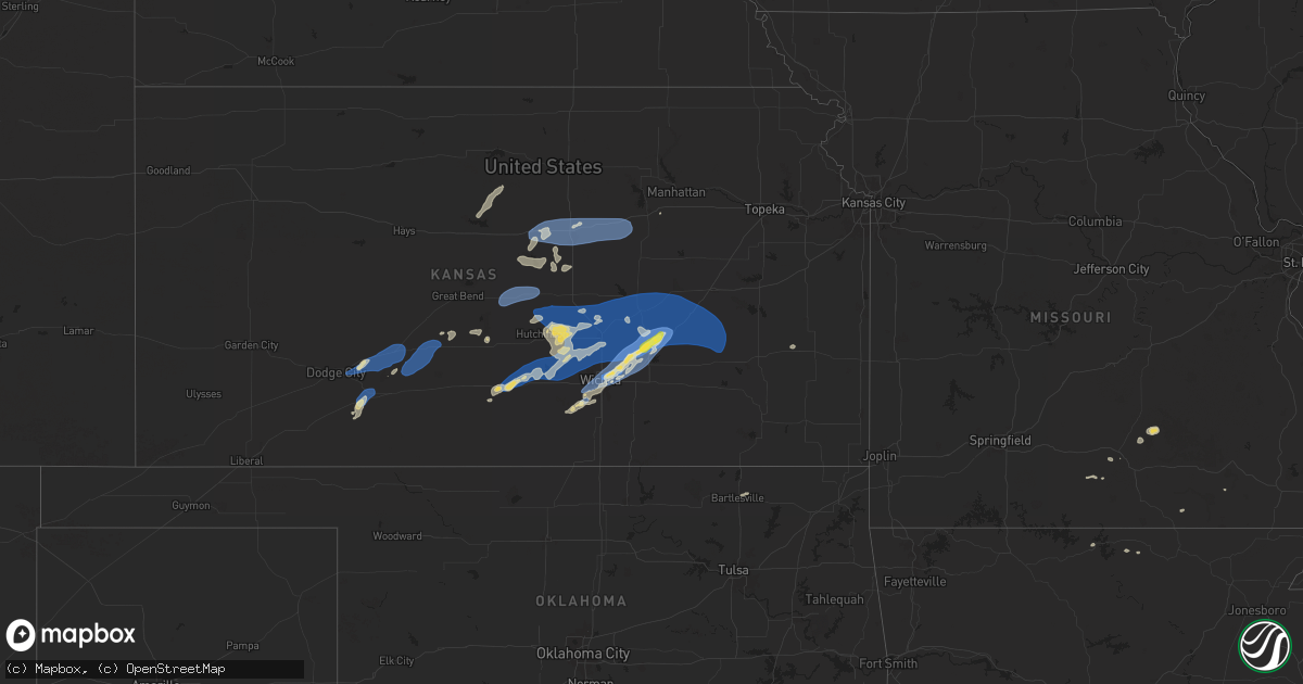
Hail Map on September 20, 2024
Get this storm
September 20 map
$229
one time, instant access
Download today. No call, no setup
Keep the $229
Bought the map and want the full workflow? Apply the entire $229 to a subscription within 7 days. None of it is wasted.
Every map, not just this one
This buys you this map. Subscription and you get every map we run, in the markets you choose from a few cities to whole states to nationwide. Plus real-time alerts the moment a storm fires.
Contact data
Name, contact info, occupancy, even credit band for addresses in the footprint. You go from where it hit to who to call.
Become the source they trust
Unlimited branding weather history reports on demand. You already have the documented answer ready for the property owner, and you are the one who showed up with it.
Property data and RoofTrace estimates
Pull up any address you have got, its value and the exact code rules for that jurisdiction, straight from One Click Code. Then RoofTrace estimates the squares, pitch, and roof value, priced the way you price.
States Impacted by Hail Map on September 20, 2024
Storm reports
Indiana
| Date | Description |
|---|---|
| 09/20/20244:39 PM CDT | Roof damage at an elementary school. Time estimated from radar. |
| 09/20/20243:50 PM CDT | A few large trees downed near slash pass road. Time estimated from radar. |
| 09/20/20243:47 PM CDT | Chicken coop flipped and mangled. Fence destroyed in coesse. Time estimated on radar. |
| 09/20/20243:40 PM CDT | Large trees downed along with some roof and siding damage near etna road between state road 109 and airport road. A shed was also destroyed. Time estimated from radar. |
| 09/20/20243:37 PM CDT | 8 inch diameter tree branch downed at a residence. Time estimated from radar. |
| 09/20/20243:37 PM CDT | Several large tree limbs down near state road 109 and e 300 n. Time estimated from radar. |
| 09/20/20243:13 PM CDT | Several large tree branches downed in the jellystone park area. Time estimated from radar. |
| 09/20/20243:10 PM CDT | Large tree downed... North side of irish lake. Time estimated from radar. |
| 09/20/20243:07 PM CDT | Large tree limbs down |
| 09/20/20243:06 PM CDT | Photo on facebook showing roof and siding damage to a home on ridinger lake. Several large tree limbs down as well. Time estimated via radar. |
| 09/20/20243:06 PM CDT | Several large tree limbs down |
| 09/20/20243:05 PM CDT | Large tree limb down |
| 09/20/20243:04 PM CDT | Tree down onto powerlines across sr 13 at the intersection with e 200 n. Time estimated via radar. |
| 09/20/20243:03 PM CDT | Tree down on in 13 near big barbee lake. Photo on facebook of large tree limbs down and a report of four flag poles snapped. Time estimated via radar. |
| 09/20/20243:03 PM CDT | Several large tree limbs snapped |
| 09/20/20243:03 PM CDT | Roof damage to a home on chapman lake. Time estimated via radar. |
| 09/20/20243:02 PM CDT | Photos on facebook show damage to several piers on chapman lake. A boat lift was also lifted and damaged. Time estimated via radar. |
| 09/20/20243:02 PM CDT | Tree branches snapped |
| 09/20/20243:02 PM CDT | Broadcast media reports tree limbs down north of warsaw near chapman lake. Time estimated from radar. |
| 09/20/20243:01 PM CDT | Nws employee reports widespread 1-3 inch limbs downed... Numerous 5-8 inch branches down... And a few snapped 12 inch tree limbs in the barrington hills and north winds |
| 09/20/20243:01 PM CDT | Tree down on train tracks at levi lee rd near n old in-13. Time estimated via radar. |
| 09/20/20243:00 PM CDT | Levi lee road is impassable due to several trees down. |
| 09/20/20243:00 PM CDT | Tree fell onto a mobile home off of levi lee road. No one was home at the time so there were no injuries. Time estimated via radar. |
| 09/20/20243:00 PM CDT | Large tree limb downed in near the us 15 and 300 e vicinity. Time estimated from radar. |
| 09/20/20243:00 PM CDT | Trees limbs down near in-15. Time estimated via radar. |
| 09/20/20243:00 PM CDT | Large tree limbs down on a car. No injuries. Time estimated via radar. |
| 09/20/20243:00 PM CDT | Powerlines and tree limbs down in pierceton. Time estimated via radar. |
| 09/20/20243:00 PM CDT | Roof damage to a home near warsaw municipal airport. Shingles ripped off and peeled back. Time estimated via radar. |
| 09/19/20248:23 PM CDT | Large limb down on car. |
| 09/19/20247:47 PM CDT | Tree downed on a house on mellowood dr. |
| 09/19/20247:45 PM CDT | Trees and limbs downed in and near the southern dunes neighborhood. |
Montana
| Date | Description |
|---|---|
| 09/20/20245:07 PM CDT | Asos station khvr havre airport. |
| 09/20/20245:07 PM CDT | Asos station khvr ha |
| 09/20/20244:57 PM CDT | Corrects previous tstm wnd gst report from 4 w havre. Asos station khvr havre airport. |
| 09/20/20244:57 PM CDT | Asos station khvr havre airport. |
| 09/20/20243:48 PM CDT | Delayed report. Ambient station northeast of chester measured a max gust of 60 mph. |
| 09/20/20243:30 PM CDT | Mesonet station gw4063 eagle creek colony. |
| 09/19/202410:00 PM CDT | Mtdot site at us-2 stateline. |
| 09/19/20249:45 PM CDT | Mesonet station mtsoo 16.0 sw bainville |
| 09/19/20249:45 PM CDT | Me |
| 09/19/20249:18 PM CDT | Mesonet station popm8 poplar raws. |
| 09/19/20248:43 PM CDT | Asos station kolf wolf point airport. |
| 09/19/20247:55 PM CDT | Also reported pea-sized hail... A tree limb 6 inches in diameter fallen off tree... Patio furniture blown away... And 0.37 inches of rain so far. Time estimated from ra |
Kansas
| Date | Description |
|---|---|
| 09/20/20246:50 PM CDT | A local report indicates 64 MPH wind near 1 WSW Pretty Prairie |
| 09/20/20246:50 PM CDT | A local report indicates 64 MPH wind near 1 WSW PRETTY PRAIRIE |
| 09/20/20246:49 PM CDT | A local report indicates 70 MPH wind near 3 W Inman |
| 09/20/20246:49 PM CDT | Public report via mping of 3-inch tree limbs broken and power poles broken. Time matched to previous report. |
| 09/20/20246:49 PM CDT | Public report via mping of 3-inch tree limbs broken and power poles broken. Time matched to previous report. |
| 09/20/20246:49 PM CDT | A local report indicates 70 MPH wind near 3 W INMAN |
| 09/20/20246:44 PM CDT | Trained spotter estimates 60 to 65 mph. An empty tank was blown off a trailer. |
| 09/20/20246:44 PM CDT | Trained spotter estimates 60 to 65 mph. An empty tank was blown off a trailer. |
| 09/20/20246:43 PM CDT | Semi blew over on interstate 70 near mile marker 239. Time is estimated from radar. |
| 09/20/20246:43 PM CDT | Semi blew over on interstate 70 near mile marker 239. Time is estimated from radar. |
| 09/20/20246:39 PM CDT | A local report indicates 60 MPH wind near 6 WSW GLENDALE |
| 09/20/20246:39 PM CDT | A local report indicates 60 MPH wind near 6 WSW Glendale |
| 09/20/20246:38 PM CDT | A local report indicates 65 MPH wind near 1 N Kingman |
| 09/20/20246:38 PM CDT | A local report indicates 65 MPH wind near 1 N KINGMAN |
| 09/20/20246:20 PM CDT | A local report indicates 69 MPH wind near 2 W Little River |
| 09/20/20246:20 PM CDT | A local report indicates 69 MPH wind near 2 W LITTLE RIVER |
| 09/20/20245:49 PM CDT | A u-haul trailer was reported to have blown over on the west side of lyons. Time estimated from radar. |
| 09/20/20245:49 PM CDT | A u-haul trailer was reported to have blown over on the west side of lyons. Time estimated from radar. |
| 09/20/20245:43 PM CDT | A local report indicates 62 MPH wind near Great Bend Airport |
| 09/20/20245:43 PM CDT | A local report indicates 62 MPH wind near GREAT BEND AIRPORT |
| 09/20/20245:09 PM CDT | A local report indicates 59 MPH wind near 2 SW Belpre |
| 09/20/20244:49 PM CDT | A local report indicates 61 MPH wind near 1 S Kinsley |
| 09/19/202410:14 PM CDT | Quarter sized hail and 53 mph winds. |
| 09/19/202410:14 PM CDT | Quarter sized hail and 53 mph winds. |
| 09/19/202410:07 PM CDT | 15 power poles were snapped. A large outbuilding/barn had doors collapse. Time estimated via radar. |
| 09/19/202410:07 PM CDT | 15 power poles were snapped. A large outbuilding/barn had doors collapse. Time estimated via radar. |
| 09/19/202410:07 PM CDT | Report of 15 power poles snapped along with a large outbuilding having overhead doors collapsed. Time estimated from radar. |
| 09/19/20249:38 PM CDT | Kwch meteorologist reports 63 mph wind gust. |
| 09/19/20249:38 PM CDT | Kwch meteorologist reports 63 mph wind gust. |
| 09/19/20249:33 PM CDT | Several small trees are down in an apartment complex. Relayed via emergency managment. |
| 09/19/20249:33 PM CDT | Ksn relayed viewer report of nickle to quarter sized hail near jabara airport. |
| 09/19/20249:33 PM CDT | Several small trees are down in an apartment complex. Relayed via emergency managment. |
| 09/19/20249:33 PM CDT | Ksn relayed viewer report of nickle to quarter sized hail near jabara airport. |
| 09/19/20249:32 PM CDT | A local report indicates 89 MPH wind near JABARA AIRPORT |
| 09/19/20249:32 PM CDT | A local report indicates 89 MPH wind near Jabara Airport |
| 09/19/20249:27 PM CDT | Report relayed via ksn of an estimated 60 mph winds with 0.5 inch hail. |
| 09/19/20249:27 PM CDT | Report relayed via ksn of an estimated 60 mph winds with 0.5 inch hail. |
| 09/19/20249:09 PM CDT | Report called into dispatch of a power line down and tree on fire in a backyard. This was relayed via emergency management. Time is estimated from radar. |
| 09/19/20249:09 PM CDT | Report called into dispatch of a power line down and tree on fire in a backyard. This was relayed via emergency management. Time is estimated from radar. |
| 09/19/20248:22 PM CDT | Sensor over the kansas turnpike. |
| 09/19/20248:22 PM CDT | Sensor over the kansas turnpike. |
| 09/19/20248:14 PM CDT | Delayed report. Fire department reported trees damaged about 3 n of the el dorado lake |
| 09/19/20248:14 PM CDT | Delayed report. Butler county officials reported 23 power poles were damaged in the section east of hwy77 between nw 100th and nw 110 |
| 09/19/20248:14 PM CDT | Delayed report. Fire department reported trees damaged about 3 n of the el dorado lake |
| 09/19/20248:14 PM CDT | Delayed report. Butler county officials reported 23 power poles were damaged in the section east of hwy77 between nw 100th and nw 110 |
| 09/19/20247:53 PM CDT | Large metal dumpster moved and flipped into the road. |
| 09/19/20247:53 PM CDT | Large metal dumpster moved and flipped into the road. |
| 09/19/20247:22 PM CDT | 2 to 3 inch tree branch down and reported via x. |
| 09/19/20247:22 PM CDT | 2 to 3 inch tree branch down and reported via x. |
| 09/19/20247:16 PM CDT | A local report indicates 60 MPH wind near 1 W HESSTON |
| 09/19/20247:16 PM CDT | A local report indicates 60 MPH wind near 1 W Hesston |
| 09/19/20247:12 PM CDT | Trained spotter estimates 60 to 65 mph winds. |
| 09/19/20247:12 PM CDT | Trained spotter estimates 60 to 65 mph winds. |
| 09/19/20247:06 PM CDT | A local report indicates 70 MPH wind near Moundridge |
| 09/19/20247:06 PM CDT | A local report indicates 70 MPH wind near MOUNDRIDGE |
| 09/19/20247:04 PM CDT | A local report indicates 67 MPH wind near SALINA AIRPORT |
| 09/19/20247:04 PM CDT | A local report indicates 67 MPH wind near Salina Airport |
| 09/19/20247:00 PM CDT | A local report indicates 60 MPH wind near 5 ESE PARTRIDGE |
| 09/19/20247:00 PM CDT | A local report indicates 60 MPH wind near 5 ESE Partridge |
Minnesota
| Date | Description |
|---|---|
| 09/20/20246:33 AM CDT | Photo sent via facebook messenger. |
North Dakota
| Date | Description |
|---|---|
| 09/19/202410:34 PM CDT | Asos station kxwa williston airport. |
Arkansas
| Date | Description |
|---|---|
| 09/20/20244:54 PM CDT | A tree was blown down onto a power line. |
| 09/20/20244:54 PM CDT | Corrects previous tstm wnd gst report from 3 e mountain home. A tree was blown down onto a power line. |
Cities Impacted by Hail Map on September 20, 2024
- Bartlesville, OK
- Warsaw, IN
- Milford, IN
- Leesburg, IN
- Pierceton, IN
- Larwill, IN
- Columbia City, IN
- Galata, MT
- Whitlash, MT
- Chester, MT
- Inverness, MT
- Joplin, MT
- Rudyard, MT
- Drury, MO
- Kokomo, IN
- Minneola, KS
- Wright, KS
- Ford, KS
- Spearville, KS
- Bucklin, KS
- Offerle, KS
- Vanzant, MO
- Neoga, IL
- Mattoon, IL
- Gays, IL
- Windsor, IL
- Kinsley, KS
- Lewis, KS
- Trilla, IL
- Toledo, IL
- Mountain Home, AR
- Gildford, MT
- Havre, MT
- Kremlin, MT
- Chinook, MT
- Greensburg, KS
- Macksville, KS
- Belpre, KS
- Haviland, KS
- Michigantown, IN
- Frankfort, IN
- Forest, IN
- Montrose, IL
- Eunice, MO
- Yukon, MO
- Elk Creek, MO
- Houston, MO
- Sigel, IL
- Jewett, IL
- Hartshorn, MO
- Summersville, MO
- Fillmore, IL
- Bingham, IL
- Larned, KS
- Newton, IL
- St John, KS
- Bexar, AR
- Viola, AR
- Ramsey, IL
- Sheridan, IN
- Kirklin, IN
- Kempton, IN
- Salem, AR
- Hidalgo, IL
- Wheeler, IL
- Marshall, IL
- Isabel, KS
- Nashville, KS
- Stafford, KS
- Sylvia, KS
- Ellsworth, KS
- Paris, IL
- Cunningham, KS
- Dennison, IL
- Kanopolis, KS
- Geneseo, KS
- Malta, MT
- Couch, MO
- Thayer, MO
- Chase, KS
- Lyons, KS
- Little River, KS
- Buhler, KS
- Hutchinson, KS
- Inman, KS
- Kingman, KS
- Luray, KS
- Lucas, KS
- Nickerson, KS
- Brookville, KS
- Marquette, KS
- Falun, KS
- Alton, MO
- Pretty Prairie, KS
- Cheney, KS
- Murdock, KS
- Salina, KS
- Beverly, KS
- Tescott, KS
- Moundridge, KS
- Burrton, KS
- Mcpherson, KS
- Sylvan Grove, KS
- Lindsborg, KS
- Sterling, KS
- Halstead, KS
- New Cambria, KS
- Solomon, KS
- Garden Plain, KS
- Haven, KS
- Mount Hope, KS
- Colwich, KS
- Andale, KS
- Maize, KS
- North Newton, KS
- Walton, KS
- Sedgwick, KS
- Hesston, KS
- Newton, KS
- Peabody, KS
- Teutopolis, IL
- Hunter, KS
- Fort Peck, MT
- Lincoln, KS
- Beloit, KS
- Galva, KS
- Valley Center, KS
- Bentley, KS
- Elbing, KS
- Whitewater, KS
- Wichita, KS
- Arlington, KS
- Florence, KS
- Goessel, KS
- Burns, KS
- Hillsboro, KS
- Marion, KS
- Cedar Point, KS
- Bennington, KS
- Chapman, KS
- Enterprise, KS
- Gypsum, KS
- Abilene, KS
- Junction City, KS
- Woodbine, KS
- Potwin, KS
- Benton, KS
- El Dorado, KS
- Towanda, KS
- Canton, KS
- Cassoday, KS
- Sainte Genevieve, MO
- Prairie Du Rocher, IL
- Greenwood, IN
- Indianapolis, IN
- Matfield Green, KS
- Elmdale, KS
- Cottonwood Falls, KS
- Whiteland, IN
- Eureka, KS
- Emporia, KS
- Olpe, KS
- Strong City, KS
- Madison, KS
- Hamilton, KS
- Wolf Point, MT
- Frazer, MT
- Franklin, IN
- Virgil, KS
- Vida, MT
- Poplar, MT
- Brockton, MT
- Clearwater, KS
- Viola, KS
- Conway Springs, KS
- Sumner, IL
- Claremont, IL
- Richey, MT
- Lambert, MT
- Haysville, KS
- Stapleton, NE
- Andover, KS
- Kechi, KS
- Mcconnell Afb, KS
- Augusta, KS
- Greenwich, KS
- Kenmare, ND
- Iola, KS
- Peck, KS
- Tolley, ND
- Mohall, ND
- Antler, ND
- Westhope, ND
- Canby, MN
- Porter, MN
- Minneota, MN
- Boyd, MN
- Granite Falls, MN
- Maynard, MN
- Montevideo, MN
- Clarkfield, MN
- Clara City, MN
- Hanley Falls, MN
- Raymond, MN
- Sacred Heart, MN
- Renville, MN
- Wood Lake, MN
- Madison, SD
- Kandiyohi, MN
- Willmar, MN
- Saint Joseph, MN
- Atwater, MN
- Echo, MN
- Danube, MN
- Flandreau, SD