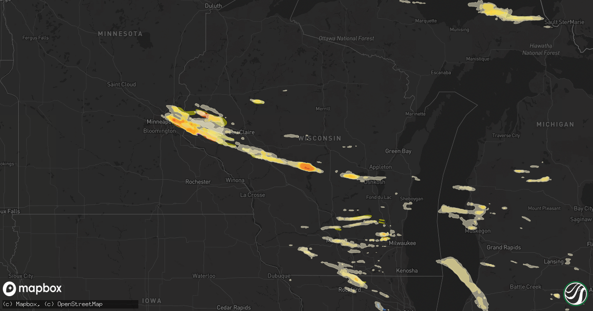
Hail Map in Wisconsin on September 20, 2022
Get this storm
September 20 map
$229
one time, instant access
Download today. No call, no setup
Keep the $229
Bought the map and want the full workflow? Apply the entire $229 to a subscription within 7 days. None of it is wasted.
Every map, not just this one
This buys you this map. Subscription and you get every map we run, in the markets you choose from a few cities to whole states to nationwide. Plus real-time alerts the moment a storm fires.
Contact data
Name, contact info, occupancy, even credit band for addresses in the footprint. You go from where it hit to who to call.
Become the source they trust
Unlimited branding weather history reports on demand. You already have the documented answer ready for the property owner, and you are the one who showed up with it.
Property data and RoofTrace estimates
Pull up any address you have got, its value and the exact code rules for that jurisdiction, straight from One Click Code. Then RoofTrace estimates the squares, pitch, and roof value, priced the way you price.
Storm reports in Wisconsin
Wisconsin
| Date | Description |
|---|---|
| 09/20/20223:50 PM CDT | Delayed report. Multiple reports of large trees down in beloit... Including one tree down on a truck. Time estimated from radar. |
| 09/20/20222:58 PM CDT | Sw side of lisbon...pictures via social media. |
| 09/20/20222:25 PM CDT | 7.3 ene of mineral point. |
| 09/20/20222:22 PM CDT | Report from mping. |
| 09/20/20221:39 PM CDT | Report from mping. |
| 09/20/20221:34 PM CDT | Report from mping. |
| 09/20/20221:27 PM CDT | Via social media with picture. |
| 09/20/20221:20 PM CDT | From woodland....via social media. |
| 09/20/20221:07 PM CDT | Via social media...time est from radar. |
| 09/20/20221:07 PM CDT | Report from mping. |
| 09/20/20221:00 PM CDT | Report from mping. |
| 09/20/20227:46 AM CDT | At 1246 PM CDT, a severe thunderstorm was located near Rio, or 10 miles northwest of Columbus, moving east at 35 mph. HAZARD...60 mph wind gusts and quarter size hail. SOURCE...Radar indicated. IMPACT...Hail damage to vehicles is expected. Expect wind damage to roofs, siding, and trees. Locations impacted include... Columbus, Randolph, Fall River, Rio, Cambria, Fox Lake, Wyocena, Otsego, Friesland, Doylestown, Danville and Astico. |
| 09/20/20225:17 AM CDT | At 1017 PM CDT, a severe thunderstorm was located near Sheldon, or 12 miles south of Ladysmith, moving east at 35 mph. HAZARD...Half dollar size hail. SOURCE...Radar indicated. IMPACT...Damage to vehicles is expected. This severe thunderstorm will be near... Sheldon around 1025 PM CDT. |
| 09/20/20225:00 AM CDT | At 1000 PM CDT, a severe thunderstorm was located 6 miles south of Woodville, or 16 miles east of River Falls, moving east at 45 mph. HAZARD...Half dollar size hail. SOURCE...Radar indicated. IMPACT...Damage to vehicles is expected. This severe thunderstorm will be near... Elmwood around 1010 PM CDT. Eau Galle around 1020 PM CDT. |
| 09/20/20224:54 AM CDT | At 953 PM CDT, a severe thunderstorm was located near Durand, or 10 miles northwest of Mondovi, moving southeast at 35 mph. HAZARD...Half dollar size hail. SOURCE...Radar indicated. IMPACT...Damage to vehicles is expected. This severe thunderstorm will be near... Mondovi around 1010 PM CDT. Strum around 1030 PM CDT. Whitehall around 1045 PM CDT.This includes Interstate 94 between mile markers 88 and 91. |
| 09/20/20224:28 AM CDT | At 927 PM CDT, severe thunderstorms were located along a line extending from 5 miles northwest of Chippewa Falls to 5 miles southwest of Elmwood, moving southeast at 35 mph. HAZARD...Two inch hail. SOURCE...Radar indicated. IMPACT...People and animals outdoors will be injured. Expect damage to roofs, siding, windows, and vehicles. Severe thunderstorms will be near... Chippewa Falls around 935 PM CDT. Lake Wissota around 940 PM CDT.Other locations in the path of these severe thunderstorms includeDurand, Cadott, Boyd and Stanley. |
| 09/20/20223:50 AM CDT | At 850 PM CDT, a severe thunderstorm was located near River Falls, moving east at 40 mph. HAZARD...Two inch hail. SOURCE...Radar indicated. IMPACT...People and animals outdoors will be injured. Expect damage to roofs, siding, windows, and vehicles. This severe thunderstorm will be near... Baldwin around 900 PM CDT. Woodville around 905 PM CDT.Other locations in the path of this severe thunderstorm includeElmwood and Eau Galle. |
| 09/20/20223:46 AM CDT | At 845 PM CDT, a severe thunderstorm was located over Wheeler, or 9 miles north of Menomonie, moving east at 40 mph. HAZARD...Ping pong ball size hail. SOURCE...Radar indicated. IMPACT...People and animals outdoors will be injured. Expect damage to roofs, siding, windows, and vehicles. This severe thunderstorm will be near... Colfax around 905 PM CDT.Other locations in the path of this severe thunderstorm include ElkMound, Lake Hallie, Chippewa Falls, Altoona and Lake Wissota. |
| 09/20/20223:13 AM CDT | At 813 PM CDT, a severe thunderstorm was located over White Bear Lake, or 8 miles northeast of St. Paul, moving east at 40 mph. HAZARD...Half dollar size hail. SOURCE...Radar indicated. IMPACT...Damage to vehicles is expected. This severe thunderstorm will be near... Woodbury, Stillwater, Lake Elmo and Afton around 825 PM CDT. Bayport around 830 PM CDT.Other locations in the path of this severe thunderstorm includeHudson, North Hudson and Roberts. |
| 09/20/20221:35 AM CDT | Report from mping. Half dollar sized hail. |
| 09/20/20221:30 AM CDT | Most hailstones around 1 inch to 1 and a quarter inch. One hailstone was 1 and seven eighths inches long. |
| 09/20/20221:30 AM CDT | Half dollar sized hail lasting approximately 3 minutes. |
| 09/20/202212:18 AM CDT | Hail lasted for 8 min. Cranberry/ag survey- divots. |
| 09/20/202212:10 AM CDT | Hail lasted for 10 min. Damage to vehicles. Pictures of sent via email. |
| 09/20/202212:00 AM CDT | Report via facebook photo. Time estimated from radar. |
| 09/19/202210:21 PM CDT | Localized ponding on roadways. Time estimated via radar. |
| 09/19/202210:10 PM CDT | Time estimated via radar. |
| 09/19/20229:56 PM CDT | At 255 PM CDT, severe thunderstorms were located along a line extending from near Lake Mills to near Cambridge, moving southeast at 25 mph. HAZARD...Quarter size hail. SOURCE...Radar indicated. IMPACT...Damage to vehicles is expected. Locations impacted include... Whitewater, Fort Atkinson, Jefferson, Lake Mills, Milton, Edgerton, Johnson Creek, Palmyra, Cambridge, Lake Ripley, Lake Koshkonong, Rome, La Grange, Albion, Hebron, Sullivan, Utica, Rockdale, Busseyville and Helenville. |
| 09/19/20229:24 PM CDT | At 224 PM CDT, a severe thunderstorm was located 8 miles northwest of Blanchardville, or 9 miles southeast of Dodgeville, moving east at 30 mph. HAZARD...Quarter size hail. SOURCE...Radar indicated. IMPACT...Damage to vehicles is expected. Locations impacted include... Western Madison, Fitchburg, Verona, Mount Horeb, Belleville, New Glarus, Blanchardville, Barneveld, Blue Mounds, Dayton, Waldwick, Hollandale, Attica, Paoli, Blue Mound St Park, Mount Vernon and Jonesdale.This includes the following Location York Memorial Church. |
| 09/19/20229:16 PM CDT | At 216 PM CDT, a severe thunderstorm was located over eastern Madison, moving east at 35 mph. HAZARD...Quarter size hail. SOURCE...Radar indicated. IMPACT...Damage to vehicles is expected. Locations impacted include... Madison, Sun Prairie, Fitchburg, McFarland, Monona, Lake Mills, Marshall, Waterloo, Cottage Grove, Deerfield, Shorewood Hills, Cambridge, Maple Bluff, Lake Ripley, Rockdale, Deansville, Camp Randall Stadium, Hubbleton, Henry Vilas Zoo and UW-Madison.This includes the following Location Wisconsin State Capitol. |
| 09/19/20229:10 PM CDT | Trained spotter measured quarter sized hail just north of menomonie. |
| 09/19/20228:54 PM CDT | Trained spotter measured tennis ball sized hail near river falls... Wi. |
| 09/19/20228:50 PM CDT | Report from mping: half dollar |
| 09/19/20228:46 PM CDT | A social media picture of 3 inch hail in river falls. There has been several calls from river falls of baseball size hail since 850 lst. |
| 09/19/20228:45 PM CDT | Trained spotter measured 3 inch hail one mile nw of river falls... Wi. |
| 09/19/20228:42 PM CDT | Hail between tennis ball and baseball size. |
| 09/19/20228:35 PM CDT | Trained spotter reported 1.5 inch hail 2 miles south of hudson. Time estimated by radar. |
| 09/19/20228:20 PM CDT | Trained spotter measured quarter sized hail in new richmond. Time estimated via radar. |
| 09/19/20228:14 PM CDT | At 113 PM CDT, a severe thunderstorm was located near Deforest, or near Windsor, moving east at 45 mph. HAZARD...60 mph wind gusts and quarter size hail. SOURCE...Radar indicated. IMPACT...Hail damage to vehicles is expected. Expect wind damage to roofs, siding, and trees. Locations impacted include... Sun Prairie, Watertown, Columbus, Marshall, Waterloo, Juneau, Deforest, Fall River, Arlington, Reeseville, Richwood, Clyman, Lowell, Deansville, East Bristol, Morrisonville, Hubbleton and Danville. |
| 09/19/20228:01 PM CDT | At 100 PM CDT, a severe thunderstorm was located near Beaver Dam, moving east at 40 mph. HAZARD...Golf ball size hail and 60 mph wind gusts. SOURCE...Radar indicated. IMPACT...People and animals outdoors will be injured. Expect hail damage to roofs, siding, windows, and vehicles. Expect wind damage to roofs, siding, and trees. Locations impacted include... Beaver Dam, Hartford, Mayville, Horicon, Juneau, Theresa, Hustisford, Iron Ridge, Burnett, Addison, Rubicon, Woodland, Neosho, Wayne, Clyman, Lowell, Kekoskee, Nenno, South Beaver Dam and Saint Lawrence. |
All States Impacted by Hail Map on September 20, 2022
Cities Impacted by Hail Map on September 20, 2022
- Bruce, WI
- Holcombe, WI
- Sheldon, WI
- Conrath, WI
- Wheeler, WI
- Colfax, WI
- Marion, MI
- Catawba, WI
- Manitowoc, WI
- Elk Mound, WI
- Cambria, WI
- Milwaukee, WI
- Fremont, MI
- Pine River, WI
- Wautoma, WI
- Berlin, WI
- Poy Sippi, WI
- Redgranite, WI
- Wild Rose, WI
- Watertown, WI
- Sullivan, WI
- Oconomowoc, WI
- Fremont, WI
- Omro, WI
- Winneconne, WI
- Butte Des Morts, WI
- Hilbert, WI
- Stockbridge, WI
- Oshkosh, WI
- Genoa City, WI
- Rockton, IL
- Roscoe, IL
- South Beloit, IL
- Clinton, WI
- Caledonia, IL
- Beloit, WI
- Poplar Grove, IL
- Galena, IL
- Quincy, OH
- De Graff, OH
- Perry, MI
- Williamston, MI
- Webberville, MI
- Lake Geneva, WI
- Palco, KS
- Plainville, KS
- Howell, MI
- Fowlerville, MI
- Ludington, MI
- Belle Center, OH
- Waynesfield, OH
- Roundhead, OH
- Hesperia, MI
- Eau Claire, WI
- Amherst Junction, WI
- Iola, WI
- Fox Lake, WI
- Amery, WI
- Deer Park, WI
- Star Prairie, WI
- Wisconsin Rapids, WI
- Hudson, WI
- Roberts, WI
- Wapakoneta, OH
- Lima, OH
- Cadillac, MI
- McBain, MI
- Janesville, WI
- Colgate, WI
- Hartland, WI
- Sussex, WI
- Hartford, WI
- Michigamme, MI
- Fall River, WI
- Doylestown, WI
- Horicon, WI
- Beaver Dam, WI
- Burnett, WI
- Rio, WI
- Columbus, WI
- Poynette, WI
- Juneau, WI
- Strum, WI
- Osseo, WI
- Black River Falls, WI
- Eleva, WI
- Humbird, WI
- Merrillan, WI
- Blair, WI
- Pittsville, WI
- Hixton, WI
- Alma Center, WI
- Twin Lake, MI
- Glenwood City, WI
- Muskegon, MI
- Rothbury, MI
- Hart, MI
- Whitehall, MI
- Shelby, MI
- New Era, MI
- Holton, MI
- Montague, MI
- Mears, MI
- Menomonie, WI
- Falmouth, MI
- Cambridge, WI
- Mcfarland, WI
- Cottage Grove, WI
- Lake Mills, WI
- Cross Plains, WI
- Black Earth, WI
- Middleton, WI
- Jefferson, WI
- Fort Atkinson, WI
- Helenville, WI
- Stoughton, WI
- Dousman, WI
- Madison, WI
- Deerfield, WI
- White Cloud, MI
- Delafield, WI
- Nashotah, WI
- Pewaukee, WI
- Rosewood, OH
- Urbana, OH
- Saint Paris, OH
- Middleville, MI
- Hastings, MI
- Baldwin, WI
- Wilson, WI
- Hammond, WI
- Knapp, WI
- Woodville, WI
- Spring Valley, WI
- Loyal, WI
- Marshfield, WI
- Spencer, WI
- Rubicon, WI
- Iron Ridge, WI
- Lowell, WI
- Hustisford, WI
- Reeseville, WI
- Newberry, MI
- Marion, WI
- Elkhart Lake, WI
- New Richmond, WI
- Paradise, MI
- Grand Marais, MI
- Eckerman, MI
- Sheboygan, WI
- Oostburg, WI
- Sheboygan Falls, WI
- Cedar Grove, WI
- Waldo, WI
- Tampa, FL
- Houghton Lake, MI
- Spring Green, WI
- Plain, WI
- Morrisonville, WI
- Sauk City, WI
- Mazomanie, WI
- Dane, WI
- Lodi, WI
- Deforest, WI
- Arlington, WI
- Six Lakes, MI
- Edmore, MI
- Lakeview, MI
- Brimley, MI
- Waukesha, WI
- Scottville, MI
- Cobb, WI
- Montfort, WI
- Highland, WI
- Whitewater, WI
- Greenville, MI
- Gowen, MI
- Jackson, WI
- Stratford, WI
- Randolph, WI
- Burlington, WI
- Elkhorn, WI
- Springfield, WI
- West Chicago, IL
- Wayne, IL
- Shelby, OH
- Manitou Beach, MI
- Adrian, MI
- Clayton, MI
- Ogdensburg, WI
- Slinger, WI
- Winnebago, IL
- Cherry Valley, IL
- Rockford, IL
- Auburndale, WI
- Hanover, MI
- Portage, OH
- Bowling Green, OH
- Stillwater, MN
- Downing, WI
- Andover, MN
- Afton, MN
- Circle Pines, MN
- Arkansaw, WI
- Houlton, WI
- Necedah, WI
- Neillsville, WI
- Durand, WI
- Somerset, WI
- Elmwood, WI
- Babcock, WI
- Eau Galle, WI
- Forest Lake, MN
- Beldenville, WI
- Mondovi, WI
- Bancroft, WI
- Whitehall, WI
- Fairchild, WI
- River Falls, WI
- Nekoosa, WI
- Lake Elmo, MN
- Clear Lake, WI
- Plum City, WI
- Saint Paul, MN
- Ellsworth, WI
- Bayport, MN
- Warrens, WI
- Lakeland, MN
- Minneapolis, MN
- Hancock, WI
- Boyceville, WI
- Hugo, MN
- Harrison, MI
- Gladwin, MI
- Edgerton, WI
- Mineral Point, WI
- Hollandale, WI
- Decatur, MI
- Blanchardville, WI
- Carpentersville, IL
- Barrington, IL
- Algonquin, IL
- Hampshire, IL
- Elgin, IL
- Saint Charles, IL
- Watervliet, MI
- Coloma, MI
- South Haven, MI
- Lawrence, MI
- Covert, MI
- Hartford, MI
- Eau Claire, MI
- Cassopolis, MI
- Bangor, MI
- Dowagiac, MI
- Benton Harbor, MI
- Eagle, WI
- Brodhead, WI
- Arcadia, OH
- Bloomdale, OH
- Plainfield, WI
- Almond, WI
- Machesney Park, IL
- Crystal Lake, IL
- Dundee, IL
- Huntley, IL
- Lake In The Hills, IL
- South Bend, IN
- North Liberty, IN
- Johnson Creek, WI
- Conover, OH
- Capron, IL
- Belvidere, IL
- Garden Prairie, IL
- Grover Hill, OH
- Spring Arbor, MI
- Horton, MI
- Jackson, MI
- Richfield, WI
- Lannon, WI
- Germantown, WI
- Menomonee Falls, WI
- Concord, MI
- Edwardsburg, MI
- Niles, MI
- Delavan, WI
- Milton, WI
- Marine On Saint Croix, MN
- Evansville, WI
- Footville, WI
- Hamilton, MI
- Orfordville, WI
- Monroe, WI
- Durand, IL
- Monticello, WI
- Loves Park, IL
- Albany, WI
- Marengo, IL
- South Elgin, IL
- Perrysburg, OH
- Tecumseh, MI
- Morrice, MI
- Dodgeville, WI
- Findlay, OH
- Nashville, MI
- Woodland, MI
- Vermontville, MI
- Campbellsport, WI
- Sharon, WI
- Bristol, IN
- Charlotte, MI
- Clarklake, MI
- Geneva, IL
- Holland, MI
- Hopkins, MI
- Paulding, OH
- Oakwood, OH
- Cloverdale, OH
- Williams Bay, WI
- Walworth, WI
- Woodstock, IL
- Union, IL
- Saugatuck, MI
- Brooklyn, MI
- Maple Park, IL
- Batavia, IL
- Wasco, IL
- Elburn, IL
- Barneveld, WI
- Caledonia, MI
- Allenton, WI


