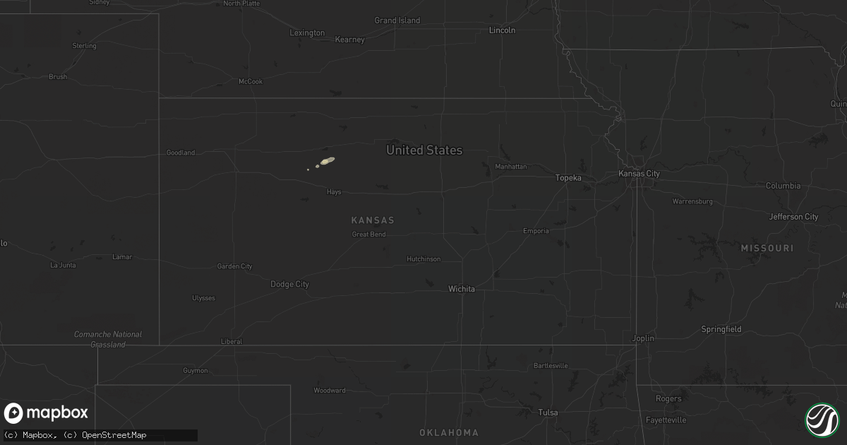
Hail Map in Kansas on September 20, 2022
Get this storm
September 20 map
$229
one time, instant access
Download today. No call, no setup
Keep the $229
Bought the map and want the full workflow? Apply the entire $229 to a subscription within 7 days. None of it is wasted.
Every map, not just this one
This buys you this map. Subscription and you get every map we run, in the markets you choose from a few cities to whole states to nationwide. Plus real-time alerts the moment a storm fires.
Contact data
Name, contact info, occupancy, even credit band for addresses in the footprint. You go from where it hit to who to call.
Become the source they trust
Unlimited branding weather history reports on demand. You already have the documented answer ready for the property owner, and you are the one who showed up with it.
Property data and RoofTrace estimates
Pull up any address you have got, its value and the exact code rules for that jurisdiction, straight from One Click Code. Then RoofTrace estimates the squares, pitch, and roof value, priced the way you price.
Storm reports in Kansas
Kansas
| Date | Description |
|---|---|
| 09/20/20223:11 AM CDT | At 811 PM CDT, a severe thunderstorm was located over Zurich, or 21 miles southeast of Hill City, moving east at 15 mph. HAZARD...60 mph wind gusts and nickel size hail. SOURCE...Radar indicated. IMPACT...Expect damage to roofs, siding, and trees. This severe thunderstorm will be near... Zurich around 820 PM CDT.Other locations in the path of this severe thunderstorm includePlainville. |
| 09/20/20222:55 AM CDT | At 755 PM CDT, severe thunderstorms were located along a line extending from near Esbon to 10 miles northeast of Portis to 6 miles south of Cedar, moving east at 20 mph. HAZARD...60 mph wind gusts. SOURCE...Radar indicated. IMPACT...Expect damage to roofs, siding, and trees. Severe thunderstorms will be near... Lebanon around 800 PM CDT. Esbon around 805 PM CDT. Gaylord around 815 PM CDT.Other locations in the path of these severe thunderstorms includeBurr Oak, Ionia, Harlan, Mankato, Glen Elder, Portis, Downs andJewell. |
| 09/20/20222:26 AM CDT | At 725 PM CDT, severe thunderstorms were located along a line extending from near Smith Center to 6 miles southeast of Speed, moving east at 15 mph. HAZARD...60 mph wind gusts and penny size hail. SOURCE...Radar indicated. IMPACT...Expect damage to roofs, siding, and trees. Severe thunderstorms will be near... Smith Center around 730 PM CDT.Other locations in the path of these severe thunderstorms includeBellaire, Lebanon and Kirwin. |
| 09/19/20227:22 PM CDT | A local report indicates 61 MPH wind near SMITH CENTER AIRPORT |
| 09/19/20227:20 PM CDT | A local report indicates 58 MPH wind near PHILLIPSBURG AIRPORT |
All States Impacted by Hail Map on September 20, 2022
Cities Impacted by Hail Map on September 20, 2022
- Bruce, WI
- Holcombe, WI
- Sheldon, WI
- Conrath, WI
- Wheeler, WI
- Colfax, WI
- Marion, MI
- Catawba, WI
- Manitowoc, WI
- Elk Mound, WI
- Cambria, WI
- Milwaukee, WI
- Fremont, MI
- Pine River, WI
- Wautoma, WI
- Berlin, WI
- Poy Sippi, WI
- Redgranite, WI
- Wild Rose, WI
- Watertown, WI
- Sullivan, WI
- Oconomowoc, WI
- Fremont, WI
- Omro, WI
- Winneconne, WI
- Butte Des Morts, WI
- Hilbert, WI
- Stockbridge, WI
- Oshkosh, WI
- Genoa City, WI
- Rockton, IL
- Roscoe, IL
- South Beloit, IL
- Clinton, WI
- Caledonia, IL
- Beloit, WI
- Poplar Grove, IL
- Galena, IL
- Quincy, OH
- De Graff, OH
- Perry, MI
- Williamston, MI
- Webberville, MI
- Lake Geneva, WI
- Palco, KS
- Plainville, KS
- Howell, MI
- Fowlerville, MI
- Ludington, MI
- Belle Center, OH
- Waynesfield, OH
- Roundhead, OH
- Hesperia, MI
- Eau Claire, WI
- Amherst Junction, WI
- Iola, WI
- Fox Lake, WI
- Amery, WI
- Deer Park, WI
- Star Prairie, WI
- Wisconsin Rapids, WI
- Hudson, WI
- Roberts, WI
- Wapakoneta, OH
- Lima, OH
- Cadillac, MI
- McBain, MI
- Janesville, WI
- Colgate, WI
- Hartland, WI
- Sussex, WI
- Hartford, WI
- Michigamme, MI
- Fall River, WI
- Doylestown, WI
- Horicon, WI
- Beaver Dam, WI
- Burnett, WI
- Rio, WI
- Columbus, WI
- Poynette, WI
- Juneau, WI
- Strum, WI
- Osseo, WI
- Black River Falls, WI
- Eleva, WI
- Humbird, WI
- Merrillan, WI
- Blair, WI
- Pittsville, WI
- Hixton, WI
- Alma Center, WI
- Twin Lake, MI
- Glenwood City, WI
- Muskegon, MI
- Rothbury, MI
- Hart, MI
- Whitehall, MI
- Shelby, MI
- New Era, MI
- Holton, MI
- Montague, MI
- Mears, MI
- Menomonie, WI
- Falmouth, MI
- Cambridge, WI
- Mcfarland, WI
- Cottage Grove, WI
- Lake Mills, WI
- Cross Plains, WI
- Black Earth, WI
- Middleton, WI
- Jefferson, WI
- Fort Atkinson, WI
- Helenville, WI
- Stoughton, WI
- Dousman, WI
- Madison, WI
- Deerfield, WI
- White Cloud, MI
- Delafield, WI
- Nashotah, WI
- Pewaukee, WI
- Rosewood, OH
- Urbana, OH
- Saint Paris, OH
- Middleville, MI
- Hastings, MI
- Baldwin, WI
- Wilson, WI
- Hammond, WI
- Knapp, WI
- Woodville, WI
- Spring Valley, WI
- Loyal, WI
- Marshfield, WI
- Spencer, WI
- Rubicon, WI
- Iron Ridge, WI
- Lowell, WI
- Hustisford, WI
- Reeseville, WI
- Newberry, MI
- Marion, WI
- Elkhart Lake, WI
- New Richmond, WI
- Paradise, MI
- Grand Marais, MI
- Eckerman, MI
- Sheboygan, WI
- Oostburg, WI
- Sheboygan Falls, WI
- Cedar Grove, WI
- Waldo, WI
- Tampa, FL
- Houghton Lake, MI
- Spring Green, WI
- Plain, WI
- Morrisonville, WI
- Sauk City, WI
- Mazomanie, WI
- Dane, WI
- Lodi, WI
- Deforest, WI
- Arlington, WI
- Six Lakes, MI
- Edmore, MI
- Lakeview, MI
- Brimley, MI
- Waukesha, WI
- Scottville, MI
- Cobb, WI
- Montfort, WI
- Highland, WI
- Whitewater, WI
- Greenville, MI
- Gowen, MI
- Jackson, WI
- Stratford, WI
- Randolph, WI
- Burlington, WI
- Elkhorn, WI
- Springfield, WI
- West Chicago, IL
- Wayne, IL
- Shelby, OH
- Manitou Beach, MI
- Adrian, MI
- Clayton, MI
- Ogdensburg, WI
- Slinger, WI
- Winnebago, IL
- Cherry Valley, IL
- Rockford, IL
- Auburndale, WI
- Hanover, MI
- Portage, OH
- Bowling Green, OH
- Stillwater, MN
- Downing, WI
- Andover, MN
- Afton, MN
- Circle Pines, MN
- Arkansaw, WI
- Houlton, WI
- Necedah, WI
- Neillsville, WI
- Durand, WI
- Somerset, WI
- Elmwood, WI
- Babcock, WI
- Eau Galle, WI
- Forest Lake, MN
- Beldenville, WI
- Mondovi, WI
- Bancroft, WI
- Whitehall, WI
- Fairchild, WI
- River Falls, WI
- Nekoosa, WI
- Lake Elmo, MN
- Clear Lake, WI
- Plum City, WI
- Saint Paul, MN
- Ellsworth, WI
- Bayport, MN
- Warrens, WI
- Lakeland, MN
- Minneapolis, MN
- Hancock, WI
- Boyceville, WI
- Hugo, MN
- Harrison, MI
- Gladwin, MI
- Edgerton, WI
- Mineral Point, WI
- Hollandale, WI
- Decatur, MI
- Blanchardville, WI
- Carpentersville, IL
- Barrington, IL
- Algonquin, IL
- Hampshire, IL
- Elgin, IL
- Saint Charles, IL
- Watervliet, MI
- Coloma, MI
- South Haven, MI
- Lawrence, MI
- Covert, MI
- Hartford, MI
- Eau Claire, MI
- Cassopolis, MI
- Bangor, MI
- Dowagiac, MI
- Benton Harbor, MI
- Eagle, WI
- Brodhead, WI
- Arcadia, OH
- Bloomdale, OH
- Plainfield, WI
- Almond, WI
- Machesney Park, IL
- Crystal Lake, IL
- Dundee, IL
- Huntley, IL
- Lake In The Hills, IL
- South Bend, IN
- North Liberty, IN
- Johnson Creek, WI
- Conover, OH
- Capron, IL
- Belvidere, IL
- Garden Prairie, IL
- Grover Hill, OH
- Spring Arbor, MI
- Horton, MI
- Jackson, MI
- Richfield, WI
- Lannon, WI
- Germantown, WI
- Menomonee Falls, WI
- Concord, MI
- Edwardsburg, MI
- Niles, MI
- Delavan, WI
- Milton, WI
- Marine On Saint Croix, MN
- Evansville, WI
- Footville, WI
- Hamilton, MI
- Orfordville, WI
- Monroe, WI
- Durand, IL
- Monticello, WI
- Loves Park, IL
- Albany, WI
- Marengo, IL
- South Elgin, IL
- Perrysburg, OH
- Tecumseh, MI
- Morrice, MI
- Dodgeville, WI
- Findlay, OH
- Nashville, MI
- Woodland, MI
- Vermontville, MI
- Campbellsport, WI
- Sharon, WI
- Bristol, IN
- Charlotte, MI
- Clarklake, MI
- Geneva, IL
- Holland, MI
- Hopkins, MI
- Paulding, OH
- Oakwood, OH
- Cloverdale, OH
- Williams Bay, WI
- Walworth, WI
- Woodstock, IL
- Union, IL
- Saugatuck, MI
- Brooklyn, MI
- Maple Park, IL
- Batavia, IL
- Wasco, IL
- Elburn, IL
- Barneveld, WI
- Caledonia, MI
- Allenton, WI


