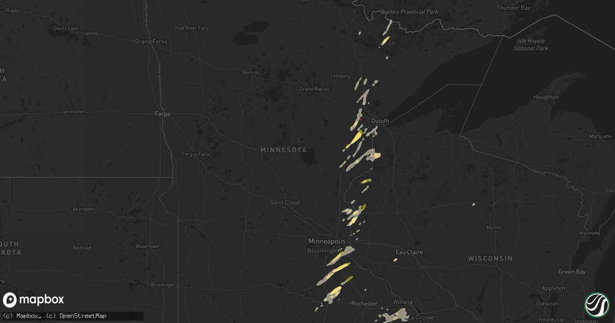
Hail Map in Minnesota on September 19, 2024
Get this storm
September 19 map
$229
one time, instant access
Download today. No call, no setup
Keep the $229
Bought the map and want the full workflow? Apply the entire $229 to a subscription within 7 days. None of it is wasted.
Every map, not just this one
This buys you this map. Subscription and you get every map we run, in the markets you choose from a few cities to whole states to nationwide. Plus real-time alerts the moment a storm fires.
Contact data
Name, contact info, occupancy, even credit band for addresses in the footprint. You go from where it hit to who to call.
Become the source they trust
Unlimited branding weather history reports on demand. You already have the documented answer ready for the property owner, and you are the one who showed up with it.
Property data and RoofTrace estimates
Pull up any address you have got, its value and the exact code rules for that jurisdiction, straight from One Click Code. Then RoofTrace estimates the squares, pitch, and roof value, priced the way you price.
Storm reports in Minnesota
Minnesota
| Date | Description |
|---|---|
| 09/19/20246:00 PM CDT | Several reports passed along of quarter to half dollar hail in kenyon at 600 pm. |
| 09/19/20245:58 PM CDT | Lot of hail... Largest was ping pong ball size. |
| 09/19/20245:55 PM CDT | A local report indicates 1.00 inch wind near 3 SE Brookston |
| 09/19/20245:45 PM CDT | A local report indicates 1.25 inch wind near 2 NW Nemadji |
| 09/19/20245:44 PM CDT | A local report indicates 1.00 inch wind near 5 NE Mahtowa |
| 09/19/20245:40 PM CDT | Damage to cars on interstate 35 near mahtowa. |
| 09/19/20245:39 PM CDT | Report via social media with photo. |
| 09/19/20245:19 PM CDT | Report from mping: quarter |
| 09/19/20245:15 PM CDT | Photo via social media of a tornado on the ground northwest of lake elora. Location and time estimated. |
| 09/19/20245:14 PM CDT | Corrects timing of previous tornado report from 2 ese cotton. At least 35 pine trees snapped at base on the north side of bug creek rd. |
| 09/19/20245:14 PM CDT | Roof shingles torn from two-story home and debris strewn. Time estimated from radar. |
| 09/19/20245:11 PM CDT | Picture on social media showed 1 inch hail. |
| 09/19/20245:10 PM CDT | 2 aspen uprooted and 2 aspen snapped at least above 10 feet from base of trunk. |
| 09/19/20245:06 PM CDT | Several trees 1 foot in diameter blown onto three lakes rd. |
| 09/19/20245:06 PM CDT | Tornado reported crossing highway 53 north canyon. |
| 09/19/20245:05 PM CDT | Multiple trees down along the highway via photo from social media. |
| 09/19/20245:05 PM CDT | 4 pine trees 1 foot in diameter snapped 10 feet up from base. |
| 09/19/20245:05 PM CDT | Multiple trees down along the highway via photo from social media. |
| 09/19/20245:05 PM CDT | 4 pine trees 1 foot in diameter snapped 10 feet up from base. |
| 09/19/20245:03 PM CDT | From photo on social media. |
| 09/19/20244:37 PM CDT | A local report indicates 1.00 inch wind near Northfield |
| 09/19/20244:25 PM CDT | One tree down along county road 14. |
| 09/19/20244:05 PM CDT | A local report indicates 60 MPH wind near 3 NE Ostrander |
| 09/19/20244:02 PM CDT | Semi blown over on highway 63. |
| 09/19/20243:23 PM CDT | Trees down near 610th ave and 205th st. |
| 09/19/20243:02 PM CDT | Delayed report... Time estimated from radar. Trees down in gordonsville. |
| 09/19/20243:01 PM CDT | Delayed report... Time estimated from radar. Dozens of mature trees down along 810th ave. |
| 09/19/20245:08 AM CDT | At least 35 pine trees snapped at base on the north side of bug creek rd. |
| 09/18/20247:14 PM CDT | Report from mping: half dollar . (m |
| 09/18/20247:14 PM CDT | Report from mping: half dollar |
| 09/18/20247:07 PM CDT | Penny to quarter size hail. |
All States Impacted by Hail Map on September 19, 2024
Cities Impacted by Hail Map on September 19, 2024
- Eveleth, MN
- Makinen, MN
- Orr, MN
- Weston, MO
- Dearborn, MO
- Gower, MO
- Agency, MO
- Faucett, MO
- Edgerton, MO
- Wesley, IA
- Titonka, IA
- Britt, IA
- Woden, IA
- Burt, IA
- Forest City, IA
- Bancroft, IA
- Thompson, IA
- Leland, IA
- Buffalo Center, IA
- Lakota, IA
- Lake Mills, IA
- Scarville, IA
- Joice, IA
- Northwood, IA
- Emmons, MN
- Delray Beach, FL
- Glenville, MN
- Austin, MN
- Lyle, MN
- Saint Ansgar, IA
- Rose Creek, MN
- Adams, MN
- Brantwood, WI
- Owatonna, MN
- Graettinger, IA
- Estherville, IA
- Ringsted, IA
- Taopi, MN
- Elkton, MN
- Wallingford, IA
- Le Roy, MN
- Grand Meadow, MN
- Winfield, KS
- Dexter, MN
- Ostrander, MN
- Spring Valley, MN
- Wykoff, MN
- Preston, MN
- Fountain, MN
- Armstrong, IA
- Ely, MN
- Lanesboro, MN
- Fenton, IA
- Faribault, MN
- Chatfield, MN
- Dundas, MN
- Burden, KS
- Swea City, IA
- Medford, OK
- Deer Creek, OK
- Braman, OK
- Nardin, OK
- Blackwell, OK
- Newkirk, OK
- Cotton, MN
- Northfield, MN
- Cambridge, KS
- Dexter, KS
- Lonsdale, MN
- Gilbert, MN
- Utica, MN
- Saint Charles, MN
- Peterson, MN
- Ponca City, OK
- Arkansas City, KS
- Farmington, MN
- Rosemount, MN
- Forbes, MN
- New Richland, MN
- Hinckley, MN
- Sandstone, MN
- Willow River, MN
- Rushford, MN
- Canyon, MN
- Meadowlands, MN
- Randolph, MN
- Saint Paul Park, MN
- Cottage Grove, MN
- Orchard, IA
- Osage, IA
- Moose Lake, MN
- Sturgeon Lake, MN
- Geuda Springs, KS
- Hastings, MN
- Winona, MN
- Houston, MN
- Lewiston, MN
- Finlayson, MN
- Saint Paul, MN
- Afton, MN
- Cedar Vale, KS
- Riceville, IA
- Elma, IA
- Barnum, MN
- Toronto, KS
- Walker, MO
- River Falls, WI
- Yates Center, KS
- Virgil, KS
- Severy, KS
- Askov, MN
- Lime Springs, IA
- Carlton, MN
- Clarion, IA
- Fall River, KS
- Harcourt, IA
- Medford, MN
- West Concord, MN
- Kenyon, MN
- Schell City, MO
- Sawyer, MN
- Hudson, WI
- Belmond, IA
- Cresco, IA
- Scandia, MN
- Marine On Saint Croix, MN
- Lakeville, MN
- Dayton, IA
- Bruno, MN
- Osceola, WI
- Harwood, MO
- Piqua, KS
- Fredonia, KS
- Duncombe, IA
- Cloquet, MN
- Red Rock, OK
- Kilkenny, MN
- Marland, OK
- Hanlontown, IA
- Claremont, MN
- Kerrick, MN
- Holyoke, MN
- El Dorado Springs, MO
- Meservey, IA
- Goodell, IA
- Thornton, IA
- Garnett, KS
- Stratford, IA
- Saginaw, MN
- Brookston, MN
- Parker, KS
- Greeley, KS
- Lane, KS
- Centerville, KS
- Kensett, IA
- Amery, WI
- Star Prairie, WI
- Pawnee, OK
- Benedict, KS
- Altoona, KS
- Pawhuska, OK
- Burbank, OK
- Shidler, OK
- Dresser, WI
- Saint Croix Falls, WI
- Lindstrom, MN
- Center City, MN
- Chisago City, MN
- Wanamingo, MN
- Kincaid, KS
- Clear Lake, IA
- Ventura, IA
- Chanute, KS
- Ralston, OK
- Decorah, IA
- Mason City, IA
- Osawatomie, KS
- Fontana, KS
- La Cygne, KS
- Centuria, WI
- Thayer, KS
- Forest Lake, MN
- La Harpe, KS
- Neodesha, KS
- Spring Grove, MN
- Cushing, WI
- Frederic, WI
- Cannon Falls, MN
- Mound City, KS
- Pleasanton, KS
- Zumbro Falls, MN
- Taylors Falls, MN
- Shafer, MN
- Dorchester, IA
- Galesburg, KS
- Webster, WI
- Moran, KS
- Stanhope, IA
- Boone, IA
- Paola, KS
- Parsons, KS
- Eitzen, MN
- Cherryvale, KS
- Erie, KS
- New Albin, IA
- Hampton, MN
- Welch, MN
- Zumbrota, MN
- Goodhue, MN
- Fayette, IA
- Babbitt, MN
- Amsterdam, MO
- Louisburg, KS
- Siren, WI
- Drexel, MO
- Maramec, OK
- Saint Paul, KS
- Jewell, IA
- Story City, IA
- Caledonia, MN
- Cleveland, OK
- Freeman, MO
- Archie, MO
- Harrisonville, MO
- De Soto, WI
- Wrenshall, MN
- Cleveland, MO
- Wadena, IA
- Danbury, WI
- Genoa, WI
- Adrian, MO
- Viroqua, WI
- Houlton, WI
- Volga, IA
- Elgin, IA
- Arlington, IA
- Roland, IA
- Garden City, MO
- Morrison, OK
- Somerset, WI
- Esko, MN
- Glencoe, OK
- Oswego, KS
- Nevada, MO
- Roberts, WI
- Elkader, IA
- Saint Olaf, IA
- Superior, WI
- Pleasant Hill, MO
- East Lynne, MO
- Duluth, MN
- Milltown, WI
- New Richmond, WI
- Altamont, KS
- Columbus, KS
- McCune, KS
- Holden, MO
- Yale, OK
- Waseca, MN
- Farmersburg, IA
- Ellendale, MN
- Fairfax, OK
- Garnavillo, IA
- Ferryville, WI
- Bartlett, KS
- Edna, KS
- Hominy, OK
- Dakota, MN
- Scammon, KS
- Soldiers Grove, WI
- McGregor, IA
- Bagley, WI
- Cherokee, KS
- Weir, KS
- Pittsburg, KS
- West Mineral, KS
- Bronaugh, MO
- Ames, IA
- Cushing, OK
- Asbury, MO
- Opolis, KS
- Nevada, IA
- Edgewood, IA
- Elkport, IA
- Greeley, IA
- Earlville, IA
- Colo, IA
- Colesburg, IA
- New Vienna, IA
- State Center, IA
- Rhodes, IA
- Melbourne, IA
- Garber, IA
- Guttenberg, IA
- Blue Mound, KS
- Maxwell, IA
- Orient, IA
- Bondurant, IA
- Mingo, IA
- Collins, IA
- Creston, IA
- Mondovi, WI
- Durand, WI
- Colfax, IA
- Afton, IA
- Shannon City, IA
- Prairie City, IA
- Newton, IA
- Mitchellville, IA
- Diagonal, IA
- Thayer, IA
- Monroe, IA
- Grand River, IA
- Tingley, IA
- Ellston, IA
- Decatur, IA
- Kellerton, IA
- Balsam Lake, WI
- Lamoni, IA
- Drumright, OK
- Jennings, OK
- Stillwater, OK
- Blythedale, MO
- Davis City, IA
- Eagleville, MO
- Butler, MO


