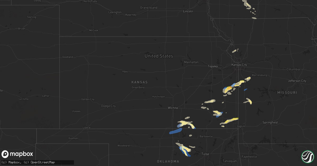
Hail Map in Kansas on September 19, 2024
Get this storm
September 19 map
$229
one time, instant access
Download today. No call, no setup
Keep the $229
Bought the map and want the full workflow? Apply the entire $229 to a subscription within 7 days. None of it is wasted.
Every map, not just this one
This buys you this map. Subscription and you get every map we run, in the markets you choose from a few cities to whole states to nationwide. Plus real-time alerts the moment a storm fires.
Contact data
Name, contact info, occupancy, even credit band for addresses in the footprint. You go from where it hit to who to call.
Become the source they trust
Unlimited branding weather history reports on demand. You already have the documented answer ready for the property owner, and you are the one who showed up with it.
Property data and RoofTrace estimates
Pull up any address you have got, its value and the exact code rules for that jurisdiction, straight from One Click Code. Then RoofTrace estimates the squares, pitch, and roof value, priced the way you price.
Storm reports in Kansas
Kansas
| Date | Description |
|---|---|
| 09/19/20246:55 PM CDT | A local report indicates 60 MPH wind near Galesburg |
| 09/19/20246:22 PM CDT | A local report indicates 60 MPH wind near 1 S Greeley |
| 09/19/20245:26 PM CDT | Camper trailer blown over off of 166 near the cowley chautauqua line. |
| 09/19/20245:26 PM CDT | Delayed report received via social media. The video shows a barn destroyed with multiple powerlines and tree limbs snapped. |
| 09/19/20245:07 PM CDT | Corrects previous tstm wnd gst report from 2 ne arkansas city. |
| 09/19/20245:02 PM CDT | Multiple power poles down along 252 st... Between 11th and 31st streets. |
| 09/19/20247:56 AM CDT | Large tree limbs downed near intersection of 183rd street and seymour road. |
| 09/18/20248:36 PM CDT | Report relayed from baker fire of quarter size hail at 180th and 400 highway in crawford county. Additionally... Power outages were reported in the same area. Time esti |
All States Impacted by Hail Map on September 19, 2024
Cities Impacted by Hail Map on September 19, 2024
- Eveleth, MN
- Makinen, MN
- Orr, MN
- Weston, MO
- Dearborn, MO
- Gower, MO
- Agency, MO
- Faucett, MO
- Edgerton, MO
- Wesley, IA
- Titonka, IA
- Britt, IA
- Woden, IA
- Burt, IA
- Forest City, IA
- Bancroft, IA
- Thompson, IA
- Leland, IA
- Buffalo Center, IA
- Lakota, IA
- Lake Mills, IA
- Scarville, IA
- Joice, IA
- Northwood, IA
- Emmons, MN
- Delray Beach, FL
- Glenville, MN
- Austin, MN
- Lyle, MN
- Saint Ansgar, IA
- Rose Creek, MN
- Adams, MN
- Brantwood, WI
- Owatonna, MN
- Graettinger, IA
- Estherville, IA
- Ringsted, IA
- Taopi, MN
- Elkton, MN
- Wallingford, IA
- Le Roy, MN
- Grand Meadow, MN
- Winfield, KS
- Dexter, MN
- Ostrander, MN
- Spring Valley, MN
- Wykoff, MN
- Preston, MN
- Fountain, MN
- Armstrong, IA
- Ely, MN
- Lanesboro, MN
- Fenton, IA
- Faribault, MN
- Chatfield, MN
- Dundas, MN
- Burden, KS
- Swea City, IA
- Medford, OK
- Deer Creek, OK
- Braman, OK
- Nardin, OK
- Blackwell, OK
- Newkirk, OK
- Cotton, MN
- Northfield, MN
- Cambridge, KS
- Dexter, KS
- Lonsdale, MN
- Gilbert, MN
- Utica, MN
- Saint Charles, MN
- Peterson, MN
- Ponca City, OK
- Arkansas City, KS
- Farmington, MN
- Rosemount, MN
- Forbes, MN
- New Richland, MN
- Hinckley, MN
- Sandstone, MN
- Willow River, MN
- Rushford, MN
- Canyon, MN
- Meadowlands, MN
- Randolph, MN
- Saint Paul Park, MN
- Cottage Grove, MN
- Orchard, IA
- Osage, IA
- Moose Lake, MN
- Sturgeon Lake, MN
- Geuda Springs, KS
- Hastings, MN
- Winona, MN
- Houston, MN
- Lewiston, MN
- Finlayson, MN
- Saint Paul, MN
- Afton, MN
- Cedar Vale, KS
- Riceville, IA
- Elma, IA
- Barnum, MN
- Toronto, KS
- Walker, MO
- River Falls, WI
- Yates Center, KS
- Virgil, KS
- Severy, KS
- Askov, MN
- Lime Springs, IA
- Carlton, MN
- Clarion, IA
- Fall River, KS
- Harcourt, IA
- Medford, MN
- West Concord, MN
- Kenyon, MN
- Schell City, MO
- Sawyer, MN
- Hudson, WI
- Belmond, IA
- Cresco, IA
- Scandia, MN
- Marine On Saint Croix, MN
- Lakeville, MN
- Dayton, IA
- Bruno, MN
- Osceola, WI
- Harwood, MO
- Piqua, KS
- Fredonia, KS
- Duncombe, IA
- Cloquet, MN
- Red Rock, OK
- Kilkenny, MN
- Marland, OK
- Hanlontown, IA
- Claremont, MN
- Kerrick, MN
- Holyoke, MN
- El Dorado Springs, MO
- Meservey, IA
- Goodell, IA
- Thornton, IA
- Garnett, KS
- Stratford, IA
- Saginaw, MN
- Brookston, MN
- Parker, KS
- Greeley, KS
- Lane, KS
- Centerville, KS
- Kensett, IA
- Amery, WI
- Star Prairie, WI
- Pawnee, OK
- Benedict, KS
- Altoona, KS
- Pawhuska, OK
- Burbank, OK
- Shidler, OK
- Dresser, WI
- Saint Croix Falls, WI
- Lindstrom, MN
- Center City, MN
- Chisago City, MN
- Wanamingo, MN
- Kincaid, KS
- Clear Lake, IA
- Ventura, IA
- Chanute, KS
- Ralston, OK
- Decorah, IA
- Mason City, IA
- Osawatomie, KS
- Fontana, KS
- La Cygne, KS
- Centuria, WI
- Thayer, KS
- Forest Lake, MN
- La Harpe, KS
- Neodesha, KS
- Spring Grove, MN
- Cushing, WI
- Frederic, WI
- Cannon Falls, MN
- Mound City, KS
- Pleasanton, KS
- Zumbro Falls, MN
- Taylors Falls, MN
- Shafer, MN
- Dorchester, IA
- Galesburg, KS
- Webster, WI
- Moran, KS
- Stanhope, IA
- Boone, IA
- Paola, KS
- Parsons, KS
- Eitzen, MN
- Cherryvale, KS
- Erie, KS
- New Albin, IA
- Hampton, MN
- Welch, MN
- Zumbrota, MN
- Goodhue, MN
- Fayette, IA
- Babbitt, MN
- Amsterdam, MO
- Louisburg, KS
- Siren, WI
- Drexel, MO
- Maramec, OK
- Saint Paul, KS
- Jewell, IA
- Story City, IA
- Caledonia, MN
- Cleveland, OK
- Freeman, MO
- Archie, MO
- Harrisonville, MO
- De Soto, WI
- Wrenshall, MN
- Cleveland, MO
- Wadena, IA
- Danbury, WI
- Genoa, WI
- Adrian, MO
- Viroqua, WI
- Houlton, WI
- Volga, IA
- Elgin, IA
- Arlington, IA
- Roland, IA
- Garden City, MO
- Morrison, OK
- Somerset, WI
- Esko, MN
- Glencoe, OK
- Oswego, KS
- Nevada, MO
- Roberts, WI
- Elkader, IA
- Saint Olaf, IA
- Superior, WI
- Pleasant Hill, MO
- East Lynne, MO
- Duluth, MN
- Milltown, WI
- New Richmond, WI
- Altamont, KS
- Columbus, KS
- McCune, KS
- Holden, MO
- Yale, OK
- Waseca, MN
- Farmersburg, IA
- Ellendale, MN
- Fairfax, OK
- Garnavillo, IA
- Ferryville, WI
- Bartlett, KS
- Edna, KS
- Hominy, OK
- Dakota, MN
- Scammon, KS
- Soldiers Grove, WI
- McGregor, IA
- Bagley, WI
- Cherokee, KS
- Weir, KS
- Pittsburg, KS
- West Mineral, KS
- Bronaugh, MO
- Ames, IA
- Cushing, OK
- Asbury, MO
- Opolis, KS
- Nevada, IA
- Edgewood, IA
- Elkport, IA
- Greeley, IA
- Earlville, IA
- Colo, IA
- Colesburg, IA
- New Vienna, IA
- State Center, IA
- Rhodes, IA
- Melbourne, IA
- Garber, IA
- Guttenberg, IA
- Blue Mound, KS
- Maxwell, IA
- Orient, IA
- Bondurant, IA
- Mingo, IA
- Collins, IA
- Creston, IA
- Mondovi, WI
- Durand, WI
- Colfax, IA
- Afton, IA
- Shannon City, IA
- Prairie City, IA
- Newton, IA
- Mitchellville, IA
- Diagonal, IA
- Thayer, IA
- Monroe, IA
- Grand River, IA
- Tingley, IA
- Ellston, IA
- Decatur, IA
- Kellerton, IA
- Balsam Lake, WI
- Lamoni, IA
- Drumright, OK
- Jennings, OK
- Stillwater, OK
- Blythedale, MO
- Davis City, IA
- Eagleville, MO
- Butler, MO


