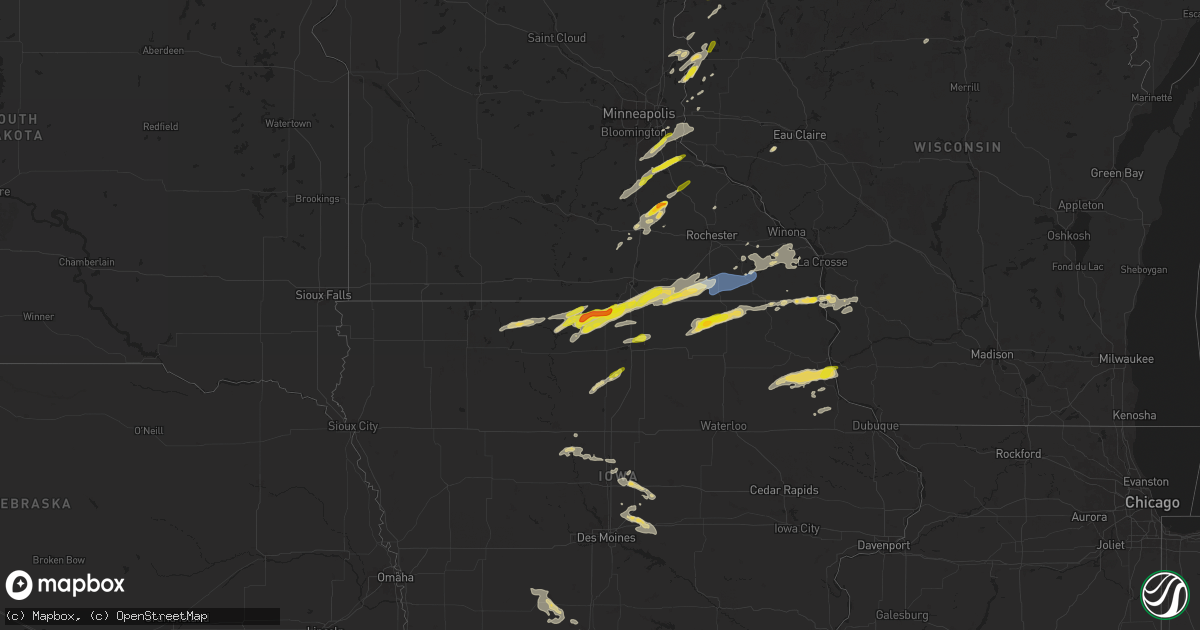
Hail Map on September 19, 2024
Get this storm
September 19 map
$229
one time, instant access
Download today. No call, no setup
Keep the $229
Bought the map and want the full workflow? Apply the entire $229 to a subscription within 7 days. None of it is wasted.
Every map, not just this one
This buys you this map. Subscription and you get every map we run, in the markets you choose from a few cities to whole states to nationwide. Plus real-time alerts the moment a storm fires.
Contact data
Name, contact info, occupancy, even credit band for addresses in the footprint. You go from where it hit to who to call.
Become the source they trust
Unlimited branding weather history reports on demand. You already have the documented answer ready for the property owner, and you are the one who showed up with it.
Property data and RoofTrace estimates
Pull up any address you have got, its value and the exact code rules for that jurisdiction, straight from One Click Code. Then RoofTrace estimates the squares, pitch, and roof value, priced the way you price.
States Impacted by Hail Map on September 19, 2024
Storm reports
Oklahoma
| Date | Description |
|---|---|
| 09/19/20245:10 PM CDT | Large tree branch fell on a parked car. This occurred in southern part of blackwell. |
| 09/18/20248:12 PM CDT | Yale police department reported wind and power damage. |
| 09/18/20247:20 PM CDT | Strong thunderstorm wind blew much of the roof from an outbuilding. |
| 09/18/20247:15 PM CDT | Report from mping: golf ball |
| 09/18/20247:05 PM CDT | A local report indicates 72 MPH wind near 3 ENE Pawnee |
| 09/18/20247:00 PM CDT | A local report indicates 70 MPH wind near 3 ENE Pawnee |
| 09/18/20247:00 PM CDT | Numerous power poles and trees down through town. Several roads closed due to the significant amount of damage. |
| 09/18/20247:00 PM CDT | *** 1 fatal *** multiple overturned rvs at pawnee lake campground; time estimated by radar and mesonet wind report; relayed by media. |
Minnesota
| Date | Description |
|---|---|
| 09/19/20246:00 PM CDT | Several reports passed along of quarter to half dollar hail in kenyon at 600 pm. |
| 09/19/20245:58 PM CDT | Lot of hail... Largest was ping pong ball size. |
| 09/19/20245:55 PM CDT | A local report indicates 1.00 inch wind near 3 SE Brookston |
| 09/19/20245:45 PM CDT | A local report indicates 1.25 inch wind near 2 NW Nemadji |
| 09/19/20245:44 PM CDT | A local report indicates 1.00 inch wind near 5 NE Mahtowa |
| 09/19/20245:40 PM CDT | Damage to cars on interstate 35 near mahtowa. |
| 09/19/20245:39 PM CDT | Report via social media with photo. |
| 09/19/20245:19 PM CDT | Report from mping: quarter |
| 09/19/20245:15 PM CDT | Photo via social media of a tornado on the ground northwest of lake elora. Location and time estimated. |
| 09/19/20245:14 PM CDT | Corrects timing of previous tornado report from 2 ese cotton. At least 35 pine trees snapped at base on the north side of bug creek rd. |
| 09/19/20245:14 PM CDT | Roof shingles torn from two-story home and debris strewn. Time estimated from radar. |
| 09/19/20245:11 PM CDT | Picture on social media showed 1 inch hail. |
| 09/19/20245:10 PM CDT | 2 aspen uprooted and 2 aspen snapped at least above 10 feet from base of trunk. |
| 09/19/20245:06 PM CDT | Tornado reported crossing highway 53 north canyon. |
| 09/19/20245:06 PM CDT | Several trees 1 foot in diameter blown onto three lakes rd. |
| 09/19/20245:05 PM CDT | Multiple trees down along the highway via photo from social media. |
| 09/19/20245:05 PM CDT | Multiple trees down along the highway via photo from social media. |
| 09/19/20245:05 PM CDT | 4 pine trees 1 foot in diameter snapped 10 feet up from base. |
| 09/19/20245:05 PM CDT | 4 pine trees 1 foot in diameter snapped 10 feet up from base. |
| 09/19/20245:03 PM CDT | From photo on social media. |
| 09/19/20244:37 PM CDT | A local report indicates 1.00 inch wind near Northfield |
| 09/19/20244:25 PM CDT | One tree down along county road 14. |
| 09/19/20244:05 PM CDT | A local report indicates 60 MPH wind near 3 NE Ostrander |
| 09/19/20244:02 PM CDT | Semi blown over on highway 63. |
| 09/19/20243:23 PM CDT | Trees down near 610th ave and 205th st. |
| 09/19/20243:02 PM CDT | Delayed report... Time estimated from radar. Trees down in gordonsville. |
| 09/19/20243:01 PM CDT | Delayed report... Time estimated from radar. Dozens of mature trees down along 810th ave. |
| 09/19/20245:08 AM CDT | At least 35 pine trees snapped at base on the north side of bug creek rd. |
| 09/18/20247:14 PM CDT | Report from mping: half dollar . (m |
| 09/18/20247:14 PM CDT | Report from mping: half dollar |
| 09/18/20247:07 PM CDT | Penny to quarter size hail. |
Iowa
| Date | Description |
|---|---|
| 09/19/20245:58 PM CDT | Moderate winds and up to quarter sized hail. |
| 09/19/20245:47 PM CDT | Delayed report. Photos of hail near quarter-sized in belmond. Size estimated based on pictures from social media. |
| 09/19/20245:24 PM CDT | Delayed report. Public reported quarter sized hail southeast of riceville. Noted damage to crops from the hail. |
| 09/19/20243:02 PM CDT | Several trees down. Time estimated by radar. |
| 09/19/20242:50 PM CDT | A local report indicates 1.00 inch wind near Lake Mills |
| 09/19/20242:35 PM CDT | A local report indicates 1.00 inch wind near Lake Mills |
| 09/19/20242:23 PM CDT | A local report indicates 1.00 inch wind near Lake Mills |
| 09/19/202410:41 AM CDT | Delayed report. Two maple trees blown down. Damage to the top of an oak tree. Power lines damaged due to fallen trees. |
| 09/18/202410:46 PM CDT | Delayed report. Large tree branch down north of reasnor. Picture submitted via social media. Time estimated from radar. |
| 09/18/202410:41 PM CDT | Corrects previous tstm wnd dmg report from 6 nne ellston. Delayed report. Two maple trees blown down. Damage to the top of an oak tree. Power lines damaged due to falle |
| 09/18/20248:20 PM CDT | Corn field flattened along the east side of hwy 52. |
| 09/18/20248:20 PM CDT | Picture sent via facebook of a barn with a blown in door and half of the roof blown off. |
Kansas
| Date | Description |
|---|---|
| 09/19/20246:55 PM CDT | A local report indicates 60 MPH wind near Galesburg |
| 09/19/20246:22 PM CDT | A local report indicates 60 MPH wind near 1 S Greeley |
| 09/19/20245:26 PM CDT | Camper trailer blown over off of 166 near the cowley chautauqua line. |
| 09/19/20245:26 PM CDT | Delayed report received via social media. The video shows a barn destroyed with multiple powerlines and tree limbs snapped. |
| 09/19/20245:07 PM CDT | Corrects previous tstm wnd gst report from 2 ne arkansas city. |
| 09/19/20245:02 PM CDT | Multiple power poles down along 252 st... Between 11th and 31st streets. |
| 09/19/20247:56 AM CDT | Large tree limbs downed near intersection of 183rd street and seymour road. |
| 09/18/20248:36 PM CDT | Report relayed from baker fire of quarter size hail at 180th and 400 highway in crawford county. Additionally... Power outages were reported in the same area. Time esti |
Missouri
| Date | Description |
|---|---|
| 09/19/20244:45 PM CDT | Emergency management and fire department report damage to a roof at a lumber yard... Some trees down... And power lines. |
| 09/19/202412:10 PM CDT | Power wires downed with power outages reported between agency and gower. |
Wisconsin
| Date | Description |
|---|---|
| 09/19/20246:29 PM CDT | A local report indicates 1.00 inch wind near 1 WNW Balsam Lake |
| 09/19/20246:04 PM CDT | A local report indicates 1.25 inch wind near 2 SE Osceola |
| 09/19/20245:28 PM CDT | Law enforcement relayed a report of multiple trees down. |
| 09/19/20245:24 PM CDT | Delayed report... Time estimated from radar. Tree down on a powerline. |
| 09/18/20247:22 PM CDT | Delayed report. Video and pictures via email and social media of large trees downed on several properties and on the roadway on ham lake road in danbury. One house also |
Cities Impacted by Hail Map on September 19, 2024
- Eveleth, MN
- Makinen, MN
- Orr, MN
- Weston, MO
- Dearborn, MO
- Gower, MO
- Agency, MO
- Faucett, MO
- Edgerton, MO
- Wesley, IA
- Titonka, IA
- Britt, IA
- Woden, IA
- Burt, IA
- Forest City, IA
- Bancroft, IA
- Thompson, IA
- Leland, IA
- Buffalo Center, IA
- Lakota, IA
- Lake Mills, IA
- Scarville, IA
- Joice, IA
- Northwood, IA
- Emmons, MN
- Delray Beach, FL
- Glenville, MN
- Austin, MN
- Lyle, MN
- Saint Ansgar, IA
- Rose Creek, MN
- Adams, MN
- Brantwood, WI
- Owatonna, MN
- Graettinger, IA
- Estherville, IA
- Ringsted, IA
- Taopi, MN
- Elkton, MN
- Wallingford, IA
- Le Roy, MN
- Grand Meadow, MN
- Winfield, KS
- Dexter, MN
- Ostrander, MN
- Spring Valley, MN
- Wykoff, MN
- Preston, MN
- Fountain, MN
- Armstrong, IA
- Ely, MN
- Lanesboro, MN
- Fenton, IA
- Faribault, MN
- Chatfield, MN
- Dundas, MN
- Burden, KS
- Swea City, IA
- Medford, OK
- Deer Creek, OK
- Braman, OK
- Nardin, OK
- Blackwell, OK
- Newkirk, OK
- Cotton, MN
- Northfield, MN
- Cambridge, KS
- Dexter, KS
- Lonsdale, MN
- Gilbert, MN
- Utica, MN
- Saint Charles, MN
- Peterson, MN
- Ponca City, OK
- Arkansas City, KS
- Farmington, MN
- Rosemount, MN
- Forbes, MN
- New Richland, MN
- Hinckley, MN
- Sandstone, MN
- Willow River, MN
- Rushford, MN
- Canyon, MN
- Meadowlands, MN
- Randolph, MN
- Saint Paul Park, MN
- Cottage Grove, MN
- Orchard, IA
- Osage, IA
- Moose Lake, MN
- Sturgeon Lake, MN
- Geuda Springs, KS
- Hastings, MN
- Winona, MN
- Houston, MN
- Lewiston, MN
- Finlayson, MN
- Saint Paul, MN
- Afton, MN
- Cedar Vale, KS
- Riceville, IA
- Elma, IA
- Barnum, MN
- Toronto, KS
- Walker, MO
- River Falls, WI
- Yates Center, KS
- Virgil, KS
- Severy, KS
- Askov, MN
- Lime Springs, IA
- Carlton, MN
- Clarion, IA
- Fall River, KS
- Harcourt, IA
- Medford, MN
- West Concord, MN
- Kenyon, MN
- Schell City, MO
- Sawyer, MN
- Hudson, WI
- Belmond, IA
- Cresco, IA
- Scandia, MN
- Marine On Saint Croix, MN
- Lakeville, MN
- Dayton, IA
- Bruno, MN
- Osceola, WI
- Harwood, MO
- Piqua, KS
- Fredonia, KS
- Duncombe, IA
- Cloquet, MN
- Red Rock, OK
- Kilkenny, MN
- Marland, OK
- Hanlontown, IA
- Claremont, MN
- Kerrick, MN
- Holyoke, MN
- El Dorado Springs, MO
- Meservey, IA
- Goodell, IA
- Thornton, IA
- Garnett, KS
- Stratford, IA
- Saginaw, MN
- Brookston, MN
- Parker, KS
- Greeley, KS
- Lane, KS
- Centerville, KS
- Kensett, IA
- Amery, WI
- Star Prairie, WI
- Pawnee, OK
- Benedict, KS
- Altoona, KS
- Pawhuska, OK
- Burbank, OK
- Shidler, OK
- Dresser, WI
- Saint Croix Falls, WI
- Lindstrom, MN
- Center City, MN
- Chisago City, MN
- Wanamingo, MN
- Kincaid, KS
- Clear Lake, IA
- Ventura, IA
- Chanute, KS
- Ralston, OK
- Decorah, IA
- Mason City, IA
- Osawatomie, KS
- Fontana, KS
- La Cygne, KS
- Centuria, WI
- Thayer, KS
- Forest Lake, MN
- La Harpe, KS
- Neodesha, KS
- Spring Grove, MN
- Cushing, WI
- Frederic, WI
- Cannon Falls, MN
- Mound City, KS
- Pleasanton, KS
- Zumbro Falls, MN
- Taylors Falls, MN
- Shafer, MN
- Dorchester, IA
- Galesburg, KS
- Webster, WI
- Moran, KS
- Stanhope, IA
- Boone, IA
- Paola, KS
- Parsons, KS
- Eitzen, MN
- Cherryvale, KS
- Erie, KS
- New Albin, IA
- Hampton, MN
- Welch, MN
- Zumbrota, MN
- Goodhue, MN
- Fayette, IA
- Babbitt, MN
- Amsterdam, MO
- Louisburg, KS
- Siren, WI
- Drexel, MO
- Maramec, OK
- Saint Paul, KS
- Jewell, IA
- Story City, IA
- Caledonia, MN
- Cleveland, OK
- Freeman, MO
- Archie, MO
- Harrisonville, MO
- De Soto, WI
- Wrenshall, MN
- Cleveland, MO
- Wadena, IA
- Danbury, WI
- Genoa, WI
- Adrian, MO
- Viroqua, WI
- Houlton, WI
- Volga, IA
- Elgin, IA
- Arlington, IA
- Roland, IA
- Garden City, MO
- Morrison, OK
- Somerset, WI
- Esko, MN
- Glencoe, OK
- Oswego, KS
- Nevada, MO
- Roberts, WI
- Elkader, IA
- Saint Olaf, IA
- Superior, WI
- Pleasant Hill, MO
- East Lynne, MO
- Duluth, MN
- Milltown, WI
- New Richmond, WI
- Altamont, KS
- Columbus, KS
- McCune, KS
- Holden, MO
- Yale, OK
- Waseca, MN
- Farmersburg, IA
- Ellendale, MN
- Fairfax, OK
- Garnavillo, IA
- Ferryville, WI
- Bartlett, KS
- Edna, KS
- Hominy, OK
- Dakota, MN
- Scammon, KS
- Soldiers Grove, WI
- McGregor, IA
- Bagley, WI
- Cherokee, KS
- Weir, KS
- Pittsburg, KS
- West Mineral, KS
- Bronaugh, MO
- Ames, IA
- Cushing, OK
- Asbury, MO
- Opolis, KS
- Nevada, IA
- Edgewood, IA
- Elkport, IA
- Greeley, IA
- Earlville, IA
- Colo, IA
- Colesburg, IA
- New Vienna, IA
- State Center, IA
- Rhodes, IA
- Melbourne, IA
- Garber, IA
- Guttenberg, IA
- Blue Mound, KS
- Maxwell, IA
- Orient, IA
- Bondurant, IA
- Mingo, IA
- Collins, IA
- Creston, IA
- Mondovi, WI
- Durand, WI
- Colfax, IA
- Afton, IA
- Shannon City, IA
- Prairie City, IA
- Newton, IA
- Mitchellville, IA
- Diagonal, IA
- Thayer, IA
- Monroe, IA
- Grand River, IA
- Tingley, IA
- Ellston, IA
- Decatur, IA
- Kellerton, IA
- Balsam Lake, WI
- Lamoni, IA
- Drumright, OK
- Jennings, OK
- Stillwater, OK
- Blythedale, MO
- Davis City, IA
- Eagleville, MO
- Butler, MO