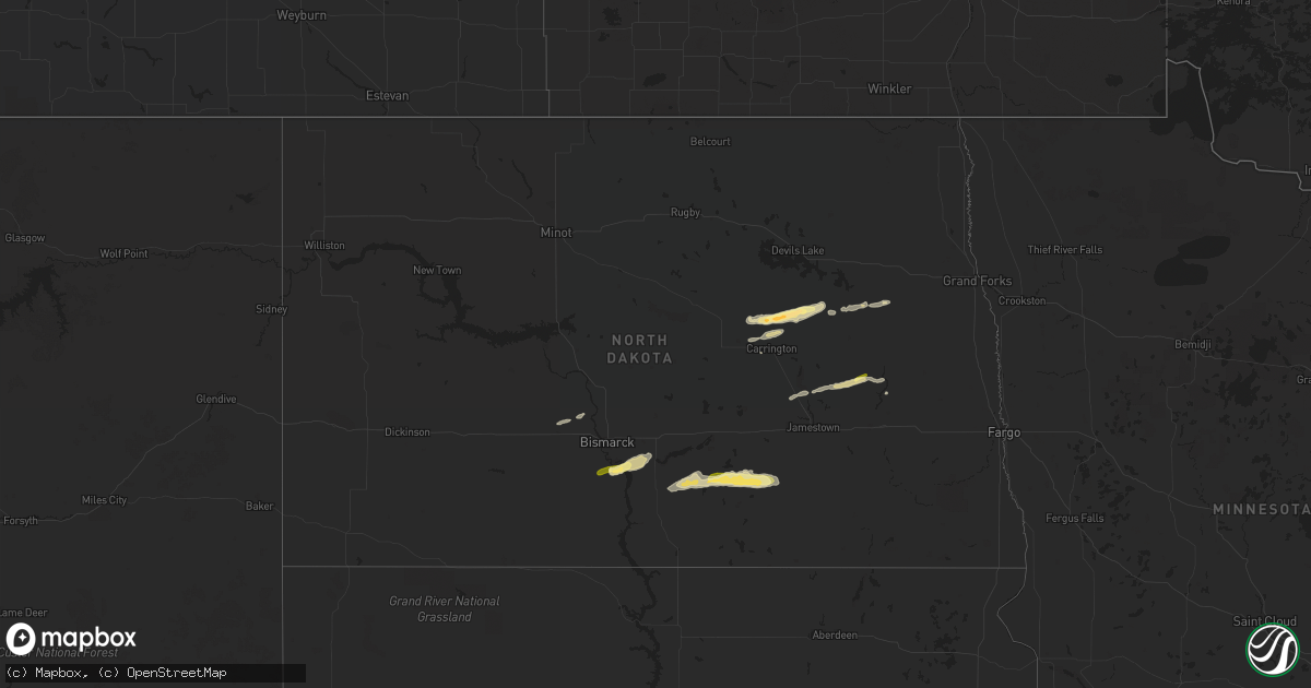
Hail Map in North Dakota on September 19, 2022
Get this storm
September 19 map
$229
one time, instant access
Download today. No call, no setup
Keep the $229
Bought the map and want the full workflow? Apply the entire $229 to a subscription within 7 days. None of it is wasted.
Every map, not just this one
This buys you this map. Subscription and you get every map we run, in the markets you choose from a few cities to whole states to nationwide. Plus real-time alerts the moment a storm fires.
Contact data
Name, contact info, occupancy, even credit band for addresses in the footprint. You go from where it hit to who to call.
Become the source they trust
Unlimited branding weather history reports on demand. You already have the documented answer ready for the property owner, and you are the one who showed up with it.
Property data and RoofTrace estimates
Pull up any address you have got, its value and the exact code rules for that jurisdiction, straight from One Click Code. Then RoofTrace estimates the squares, pitch, and roof value, priced the way you price.
Storm reports in North Dakota
North Dakota
| Date | Description |
|---|---|
| 09/19/202211:53 AM CDT | One inch hail reported by public. Crops were damaged by the hail. Time estimated from radar. |
| 09/19/202211:40 AM CDT | Relayed from broadcast media. |
| 09/19/202211:10 AM CDT | Time and location estimated by radar. |
| 09/19/20228:44 AM CDT | Facebook post. |
| 09/19/20228:30 AM CDT | Twitter post. |
| 09/19/20228:22 AM CDT | Delayed report. Relayed via broadcast media. Time estimated by radar. |
| 09/19/20227:15 AM CDT | A local report indicates 1.00 inch wind near 2 W HUFF |
| 09/19/20226:49 AM CDT | At 1149 AM CDT, a severe thunderstorm was located near Brantford, or 31 miles south of Devils Lake, moving east at 25 mph. HAZARD...Ping pong ball size hail and 60 mph wind gusts. SOURCE...Radar indicated. IMPACT...People and animals outdoors will be injured. Expect hail damage to roofs, siding, windows, and vehicles. Expect wind damage to roofs, siding, and trees. This severe thunderstorm will be near... Brantford around 1150 AM CDT.Other locations in the path of this severe thunderstorm include RedWillow Lake, Tolna and Pekin. |
| 09/19/20226:23 AM CDT | At 1122 AM CDT, a severe thunderstorm was located over New Rockford, or 31 miles south of Devils Lake, moving east at 40 mph. HAZARD...60 mph wind gusts and quarter size hail. SOURCE...Radar indicated. IMPACT...Hail damage to vehicles is expected. Expect wind damage to roofs, siding, and trees. This severe thunderstorm will be near... Brantford around 1130 AM CDT.Other locations in the path of this severe thunderstorm includeHamar. |
| 09/19/20225:55 AM CDT | At 1055 AM CDT, a severe thunderstorm was located near Wimbledon, or 28 miles northwest of Valley City, moving east at 40 mph. HAZARD...60 mph wind gusts and quarter size hail. SOURCE...Radar indicated. IMPACT...Hail damage to vehicles is expected. Expect wind damage to roofs, siding, and trees. This severe thunderstorm will be near... Dazey around 1110 AM CDT. Walum and Hannaford around 1115 AM CDT.Other locations in the path of this severe thunderstorm includeSibley, Luverne, Blabon and Hope. |
| 09/19/20223:44 AM CDT | At 844 AM CDT, a severe thunderstorm was located 6 miles southeast of Gackle, or 20 miles northwest of Edgeley, moving east at 35 mph. HAZARD...60 mph wind gusts and half dollar size hail. SOURCE...Radar indicated. IMPACT...Hail damage to vehicles is expected. Expect wind damage to roofs, siding, and trees. This severe thunderstorm will be near... Jud around 900 AM CDT.Other locations impacted by this severe thunderstorm includeNortonville, Millarton and Alfred. |
| 09/19/20222:56 AM CDT | At 756 AM CDT, a severe thunderstorm was located 5 miles northeast of Napoleon, moving east at 40 mph. HAZARD...Half dollar size hail. SOURCE...Radar indicated. IMPACT...Damage to vehicles is expected. This severe thunderstorm will be near... Streeter around 825 AM CDT. Gackle around 840 AM CDT. |
| 09/19/20222:10 AM CDT | At 710 AM CDT, a severe thunderstorm was located 10 miles south of Lincoln, or 15 miles southeast of Bismarck, moving east at 40 mph. HAZARD...Half dollar size hail. SOURCE...Radar indicated. IMPACT...Damage to vehicles is expected. This severe thunderstorm will remain over mainly rural areas of southeastern Burleigh, east central Morton and northwestern Emmons Counties, including the following locations... Moffit, Driscoll and Huff. |
| 09/19/202212:29 AM CDT | At 529 AM CDT/429 AM MDT/, severe thunderstorms were located along a line extending from 4 miles west of Heart Butte Dam to 9 miles northwest of New Leipzig, moving northeast at 35 mph. HAZARD...Quarter size hail. SOURCE...Radar indicated. IMPACT...Damage to vehicles is expected. Severe thunderstorms will be near... Heart Butte Dam around 455 AM MDT. Almont around 605 AM CDT. |
| 09/18/202211:38 PM CDT | At 438 AM MDT, a severe thunderstorm was located 8 miles northeast of Mott, moving east at 35 mph. HAZARD...Half dollar size hail. SOURCE...Radar indicated. IMPACT...Damage to vehicles is expected. This severe thunderstorm will remain over mainly rural areas of northeastern Hettinger County. |
All States Impacted by Hail Map on September 19, 2022
Cities Impacted by Hail Map on September 19, 2022
- Chetek, WI
- New Auburn, WI
- Barronett, WI
- Cumberland, WI
- Shell Lake, WI
- Sarona, WI
- Rice Lake, WI
- Luverne, ND
- Fremont, WI
- Pine River, WI
- Donna, TX
- Weyauwega, WI
- Waupaca, WI
- Mandan, ND
- Center, ND
- Mcville, ND
- Pekin, ND
- Spencer, WI
- New Rockford, ND
- Warwick, ND
- Tolna, ND
- Cathay, ND
- Mchenry, ND
- Bloomer, WI
- Cameron, WI
- Bruce, WI
- Weyerhaeuser, WI
- Barron, WI
- Bismarck, ND
- Moffit, ND
- Hazelton, ND
- Menoken, ND
- Aneta, ND
- Bancroft, WI
- Stevens Point, WI
- Junction City, WI
- Plover, WI
- Amherst, WI
- Hilton, NY
- Courtenay, ND
- Dazey, ND
- Wimbledon, ND
- Hannaford, ND
- Owen, WI
- Unity, WI
- Greenwood, WI
- Loyal, WI
- Saratoga Springs, NY
- Middle Grove, NY
- Greenfield Center, NY
- Colfax, WI
- Wisconsin Rapids, WI
- Custer, WI
- Almond, WI
- Nelsonville, WI
- Amherst Junction, WI
- Scandinavia, WI
- Carrington, ND
- Withee, WI
- Winneconne, WI
- Oshkosh, WI
- Larsen, WI
- Fort Plain, NY
- Mohawk, NY
- Little Falls, NY
- Jordanville, NY
- Saint Johnsville, NY
- Skaneateles, NY
- Auburn, NY
- Boyceville, WI
- Wheeler, WI
- Stanley, WI
- Thorp, WI
- Napoleon, ND
- Streeter, ND
- Gackle, ND
- Milltown, WI
- Luck, WI
- Ilion, NY
- Richfield Springs, NY
- West Winfield, NY
- Alma Center, WI
- Hixton, WI
- Tony, WI
- Ladysmith, WI
- Glen Flora, WI
- Pingree, ND
- Buchanan, ND
- Dallas, WI
- Prairie Farm, WI
- Kintyre, ND
- Braddock, ND
- Jud, ND
- Saint Croix Falls, WI
- Centuria, WI
- Cornell, WI
- Cadott, WI
- Colby, WI
- Jim Falls, WI
- Ridgeland, WI
- New Salem, ND
- Ballston Spa, NY
- Porter Corners, NY
- Salem, NY
- Argyle, NY
- Granville, NY
- West Pawlet, VT
- Boyd, WI
- Fredonia, ND
- Syracuse, KS
- Clayton, WI
- Conrath, WI
- Comstock, WI
- Gansevoort, NY
- Rock City Falls, NY
- Chippewa Falls, WI
- Augusta, WI
- Sykeston, ND
- Saint Anthony, ND


