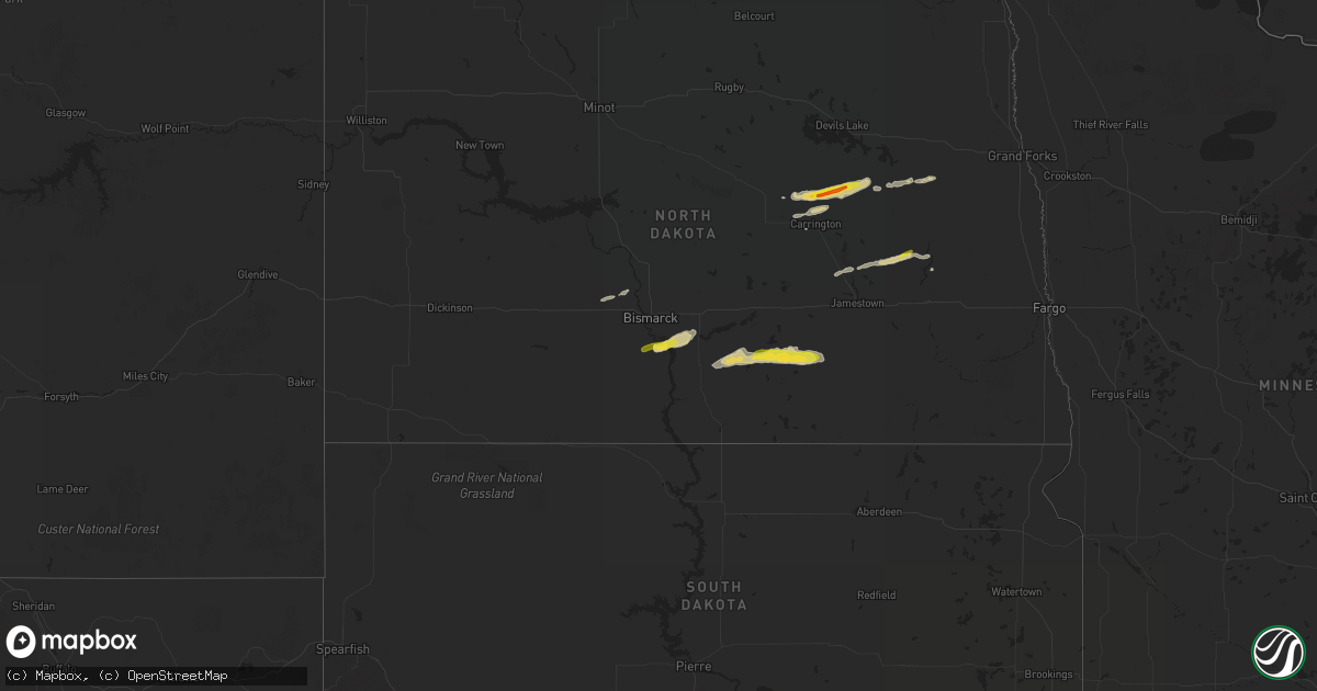
Hail Map on September 19, 2022
Get this storm
September 19 map
$229
one time, instant access
Download today. No call, no setup
Keep the $229
Bought the map and want the full workflow? Apply the entire $229 to a subscription within 7 days. None of it is wasted.
Every map, not just this one
This buys you this map. Subscription and you get every map we run, in the markets you choose from a few cities to whole states to nationwide. Plus real-time alerts the moment a storm fires.
Contact data
Name, contact info, occupancy, even credit band for addresses in the footprint. You go from where it hit to who to call.
Become the source they trust
Unlimited branding weather history reports on demand. You already have the documented answer ready for the property owner, and you are the one who showed up with it.
Property data and RoofTrace estimates
Pull up any address you have got, its value and the exact code rules for that jurisdiction, straight from One Click Code. Then RoofTrace estimates the squares, pitch, and roof value, priced the way you price.
Storm reports
North Dakota
| Date | Description |
|---|---|
| 09/19/202211:53 AM CDT | One inch hail reported by public. Crops were damaged by the hail. Time estimated from radar. |
| 09/19/202211:40 AM CDT | Relayed from broadcast media. |
| 09/19/202211:10 AM CDT | Time and location estimated by radar. |
| 09/19/20228:44 AM CDT | Facebook post. |
| 09/19/20228:30 AM CDT | Twitter post. |
| 09/19/20228:22 AM CDT | Delayed report. Relayed via broadcast media. Time estimated by radar. |
| 09/19/20227:15 AM CDT | A local report indicates 1.00 inch wind near 2 W HUFF |
| 09/19/20226:49 AM CDT | At 1149 AM CDT, a severe thunderstorm was located near Brantford, or 31 miles south of Devils Lake, moving east at 25 mph. HAZARD...Ping pong ball size hail and 60 mph wind gusts. SOURCE...Radar indicated. IMPACT...People and animals outdoors will be injured. Expect hail damage to roofs, siding, windows, and vehicles. Expect wind damage to roofs, siding, and trees. This severe thunderstorm will be near... Brantford around 1150 AM CDT.Other locations in the path of this severe thunderstorm include RedWillow Lake, Tolna and Pekin. |
| 09/19/20226:23 AM CDT | At 1122 AM CDT, a severe thunderstorm was located over New Rockford, or 31 miles south of Devils Lake, moving east at 40 mph. HAZARD...60 mph wind gusts and quarter size hail. SOURCE...Radar indicated. IMPACT...Hail damage to vehicles is expected. Expect wind damage to roofs, siding, and trees. This severe thunderstorm will be near... Brantford around 1130 AM CDT.Other locations in the path of this severe thunderstorm includeHamar. |
| 09/19/20225:55 AM CDT | At 1055 AM CDT, a severe thunderstorm was located near Wimbledon, or 28 miles northwest of Valley City, moving east at 40 mph. HAZARD...60 mph wind gusts and quarter size hail. SOURCE...Radar indicated. IMPACT...Hail damage to vehicles is expected. Expect wind damage to roofs, siding, and trees. This severe thunderstorm will be near... Dazey around 1110 AM CDT. Walum and Hannaford around 1115 AM CDT.Other locations in the path of this severe thunderstorm includeSibley, Luverne, Blabon and Hope. |
| 09/19/20223:44 AM CDT | At 844 AM CDT, a severe thunderstorm was located 6 miles southeast of Gackle, or 20 miles northwest of Edgeley, moving east at 35 mph. HAZARD...60 mph wind gusts and half dollar size hail. SOURCE...Radar indicated. IMPACT...Hail damage to vehicles is expected. Expect wind damage to roofs, siding, and trees. This severe thunderstorm will be near... Jud around 900 AM CDT.Other locations impacted by this severe thunderstorm includeNortonville, Millarton and Alfred. |
| 09/19/20222:56 AM CDT | At 756 AM CDT, a severe thunderstorm was located 5 miles northeast of Napoleon, moving east at 40 mph. HAZARD...Half dollar size hail. SOURCE...Radar indicated. IMPACT...Damage to vehicles is expected. This severe thunderstorm will be near... Streeter around 825 AM CDT. Gackle around 840 AM CDT. |
| 09/19/20222:10 AM CDT | At 710 AM CDT, a severe thunderstorm was located 10 miles south of Lincoln, or 15 miles southeast of Bismarck, moving east at 40 mph. HAZARD...Half dollar size hail. SOURCE...Radar indicated. IMPACT...Damage to vehicles is expected. This severe thunderstorm will remain over mainly rural areas of southeastern Burleigh, east central Morton and northwestern Emmons Counties, including the following locations... Moffit, Driscoll and Huff. |
| 09/19/202212:29 AM CDT | At 529 AM CDT/429 AM MDT/, severe thunderstorms were located along a line extending from 4 miles west of Heart Butte Dam to 9 miles northwest of New Leipzig, moving northeast at 35 mph. HAZARD...Quarter size hail. SOURCE...Radar indicated. IMPACT...Damage to vehicles is expected. Severe thunderstorms will be near... Heart Butte Dam around 455 AM MDT. Almont around 605 AM CDT. |
| 09/18/202211:38 PM CDT | At 438 AM MDT, a severe thunderstorm was located 8 miles northeast of Mott, moving east at 35 mph. HAZARD...Half dollar size hail. SOURCE...Radar indicated. IMPACT...Damage to vehicles is expected. This severe thunderstorm will remain over mainly rural areas of northeastern Hettinger County. |
Illinois
| Date | Description |
|---|---|
| 09/19/20227:54 AM CDT | At 1254 AM CDT, a severe thunderstorm was located near Fisher, or 10 miles south of Gibson City, moving southeast at 45 mph. HAZARD...60 mph wind gusts and half dollar size hail. SOURCE...Radar indicated. IMPACT...Hail damage to vehicles is expected. Expect wind damage to roofs, siding, and trees. This severe thunderstorm will be near... Fisher around 100 AM CDT. Mahomet and Lake Of The Woods around 105 AM CDT. Champaign and Thomasboro around 110 AM CDT.Other locations in the path of this severe thunderstorm includeUrbana, St. Joseph, Sidney, Ogden and Homer.This includes the following highways... Interstate 55 between mile markers 155 and 159. Interstate 57 between mile markers 232 and 253. Interstate 72 between mile markers 177 and 182. Interstate 74 between mile markers 132 and 197. |
| 09/19/20227:50 AM CDT | At 1249 AM CDT, a severe thunderstorm was located near Beardstown, moving southeast at 45 mph. HAZARD...60 mph wind gusts and half dollar size hail. SOURCE...Radar indicated. IMPACT...Hail damage to vehicles is expected. Expect wind damage to roofs, siding, and trees. This severe thunderstorm will be near... Beardstown around 1255 AM CDT. Bluff Springs around 100 AM CDT. Arenzville around 105 AM CDT.Other locations in the path of this severe thunderstorm includeVirginia, Jacksonville and Literberry.This includes Interstate 72 between mile markers 66 and 73. |
| 09/19/20227:36 AM CDT | At 1236 AM CDT, a severe thunderstorm was located near Mount Sterling, moving southeast at 55 mph. HAZARD...60 mph wind gusts and quarter size hail. SOURCE...Radar indicated. IMPACT...Hail damage to vehicles is expected. Expect wind damage to roofs, siding, and trees. This severe thunderstorm will remain over mainly rural areas of central Brown County, including the following locations... La Grange, Coopertown and Ripley. |
| 09/19/20227:29 AM CDT | At 1229 AM CDT, a severe thunderstorm was located near Rushville, moving east southeast at 60 mph. HAZARD...60 mph wind gusts and quarter size hail. SOURCE...Radar indicated. IMPACT...Hail damage to vehicles is expected. Expect wind damage to roofs, siding, and trees. This severe thunderstorm will be near... Beardstown, Bluff Springs and Browning around 1245 AM CDT.Other locations in the path of this severe thunderstorm includeVirginia and Chandlerville. |
| 09/19/20227:10 AM CDT | At 1209 AM CDT, a severe thunderstorm was located near Cooksville, or 10 miles east of Bloomington, moving southeast at 35 mph. HAZARD...60 mph wind gusts and quarter size hail. SOURCE...Radar indicated. IMPACT...Hail damage to vehicles is expected. Expect wind damage to roofs, siding, and trees. This severe thunderstorm will be near... Le Roy around 1220 AM CDT.Other locations in the path of this severe thunderstorm includeSaybrook and Fisher.This includes the following highways... Interstate 55 between mile markers 156 and 159, and between milemarkers 167 and 181. Interstate 74 between mile markers 132 and 155, near mile marker158, and between mile markers 162 and 169. |
| 09/19/20227:00 AM CDT | At 1200 AM CDT, severe thunderstorms were located along a line extending from near El Paso to Secor to near Washington, moving southeast at 45 mph. HAZARD...60 mph wind gusts and nickel size hail. SOURCE...Radar indicated. IMPACT...Expect damage to roofs, siding, and trees. Severe thunderstorms will be near... El Paso around 1205 AM CDT. Gridley around 1210 AM CDT. Lexington, Danvers, Carlock and Towanda around 1220 AM CDT.Other locations in the path of these severe thunderstorms includeBloomington, Normal and Hudson.This includes the following highways... Interstate 39 between mile markers 0 and 21. Interstate 55 between mile markers 159 and 172, and between milemarkers 177 and 184. Interstate 74 between mile markers 106 and 132. |
| 09/18/202210:52 PM CDT | At 352 AM CDT, a severe thunderstorm was located over Rushville, moving southeast at 40 mph. HAZARD...60 mph wind gusts and quarter size hail. SOURCE...Radar indicated. IMPACT...Hail damage to vehicles is expected. Expect wind damage to roofs, siding, and trees. This severe thunderstorm will be near... Beardstown and Browning around 405 AM CDT.Other locations in the path of this severe thunderstorm include BluffSprings. |
| 09/18/20229:33 PM CDT | At 233 AM CDT, a severe thunderstorm was located over Bentonsport/Vernon, or near Keosauqua, moving southeast at 35 mph. HAZARD...Half dollar size hail. SOURCE...Radar indicated. IMPACT...Damage to vehicles is expected. This severe thunderstorm will be near... Farmington and Indian Lake Park around 245 AM CDT. Anson and Chambersburg around 250 AM CDT.Other locations in the path of this severe thunderstorm includeBattle of Athens Campground, Revere, Peaksville, St. Francisville,Warsaw, Wayland and Alexandria. |
| 09/18/20228:47 PM CDT | At 147 AM CDT, a severe thunderstorm was located near Franklin, moving southeast at 45 mph. HAZARD...60 mph wind gusts and half dollar size hail. SOURCE...Radar indicated. IMPACT...Hail damage to vehicles is expected. Expect wind damage to roofs, siding, and trees. This severe thunderstorm will be near... Palmyra around 155 AM CDT. Virden and Girard around 205 AM CDT.Other locations in the path of this severe thunderstorm includeFarmersville, Raymond and Litchfield.This includes Interstate 55 in Illinois between exits 60 and 63. This also includes Lake Lou Yaeger. |
| 09/18/20228:41 PM CDT | At 141 AM CDT, a severe thunderstorm was located near Elvaston, or 8 miles southeast of Keokuk, moving southeast at 35 mph. HAZARD...Quarter size hail. SOURCE...Radar indicated. IMPACT...Damage to vehicles is expected. This severe thunderstorm will be near... Basco and Bentley around 150 AM CDT. West Point, Denver and Stillwell around 155 AM CDT.Other locations in the path of this severe thunderstorm includeBowen, Augusta and Hancock County Fairgrounds. |
| 09/18/20228:15 PM CDT | At 115 AM CDT, a severe thunderstorm was located over Chapin, or 8 miles northwest of Jacksonville, moving southeast at 60 mph. HAZARD...Ping pong ball size hail and 60 mph wind gusts. SOURCE...Radar indicated. IMPACT...People and animals outdoors will be injured. Expect hail damage to roofs, siding, windows, and vehicles. Expect wind damage to roofs, siding, and trees. This severe thunderstorm will be near... Jacksonville around 125 AM CDT. Murrayville and Woodson around 130 AM CDT. Alexander and Franklin around 135 AM CDT.Other locations in the path of this severe thunderstorm includeWaverly.This includes the following highways... Interstate 55 between mile markers 77 and 94. Interstate 72 between mile markers 55 and 100. |
Vermont
| Date | Description |
|---|---|
| 09/18/20229:53 PM CDT | At 252 PM EDT, a severe thunderstorm was located near Rock City Falls, or near Saratoga Springs, moving east at 30 mph. HAZARD...60 mph wind gusts and quarter size hail. SOURCE...Radar indicated. IMPACT...Hail damage to vehicles is expected. Expect wind damage to roofs, siding, and trees. Locations impacted include... Saratoga Springs, Salem, Fort Edward, Greenwich, Kings, Gates, Wilton, Greenfield, Porter, Northumberland, Schuylerville, Victory, Argyle, Cossayuna, Center Falls, Goose Island, Grangerville, Kings Station, East Hebron and Greenfield Center. |
Kansas
| Date | Description |
|---|---|
| 09/19/20223:06 AM CDT | At 806 PM MDT, a severe thunderstorm was located very Coolidge, moving east at 25 mph. HAZARD...60 mph wind gusts and nickel size hail. SOURCE...Radar indicated. IMPACT...Expect damage to roofs, siding, and trees. This severe thunderstorm will remain over mainly rural areas of northwestern Hamilton County. |
| 09/18/20229:55 PM CDT | Awos station k3k3 syracuse. |
Pennsylvania
| Date | Description |
|---|---|
| 09/18/20229:20 PM CDT | At 220 PM EDT, a severe thunderstorm was located over Sherman, or near Deposit, moving northeast at 40 mph. HAZARD...60 mph wind gusts and quarter size hail. SOURCE...Radar indicated. IMPACT...Hail damage to vehicles is expected. Expect wind damage to roofs, siding, and trees. Locations impacted include... Walton, Colchester, Deposit, Hancock, Lanesboro, Starrucca, Fishs Eddy, Harvard, Downsville and Corbett. |
New Hampshire
| Date | Description |
|---|---|
| 09/19/20224:49 PM CDT | Tree down near shopping mall off rt 202. Time estimated by radar. |
| 09/19/20224:43 PM CDT | Downed tree and several large branches on highway 137. Time estimated by radar. |
Iowa
| Date | Description |
|---|---|
| 09/18/20229:23 PM CDT | At 223 AM CDT, a severe thunderstorm was located near Pollmiller Park, or near Fort Madison, moving southeast at 55 mph. HAZARD...Quarter size hail. SOURCE...Radar indicated. IMPACT...Damage to vehicles is expected. This severe thunderstorm will be near... Niota around 230 AM CDT. Dallas City and Pontoosuc around 235 AM CDT. Adrian and Colusa around 240 AM CDT.Other locations in the path of this severe thunderstorm includeCarthage, Ferris, Burnside, Fountain Green, Bentley, Webster,Colchester, Tennessee, Colmar, Plymouth and Fandon. |
Indiana
| Date | Description |
|---|---|
| 09/18/20228:53 PM CDT | At 152 AM CDT, a severe thunderstorm was located over Broadlands, or 18 miles northeast of Tuscola, moving southeast at 50 mph. HAZARD...60 mph wind gusts and half dollar size hail. SOURCE...Radar indicated. IMPACT...Hail damage to vehicles is expected. Expect wind damage to roofs, siding, and trees. This severe thunderstorm will be near... Sidell around 200 AM CDT. Hume around 205 AM CDT.Other locations in the path of this severe thunderstorm includeChrisman.This includes Interstate 57 between mile markers 213 and 216. |
| 09/18/20228:21 PM CDT | At 121 AM CDT, a severe thunderstorm was located over Savoy, or near Champaign, moving southeast at 50 mph. HAZARD...60 mph wind gusts and half dollar size hail. SOURCE...Radar indicated. IMPACT...Hail damage to vehicles is expected. Expect wind damage to roofs, siding, and trees. This severe thunderstorm will be near... Philo and Sidney around 130 AM CDT. Villa Grove around 135 AM CDT. Broadlands around 140 AM CDT.Other locations in the path of this severe thunderstorm includeAllerton, Newman, Sidell, Hume, Brocton and Chrisman.This includes the following highways... Interstate 57 between mile markers 223 and 241. Interstate 72 between mile markers 179 and 182. Interstate 74 between mile markers 176 and 191. |
New York
| Date | Description |
|---|---|
| 09/19/20226:30 PM CDT | Trees and wires down. Some village residents without power. Relayed from fire chief by em. |
| 09/19/20224:41 PM CDT | Downed trees at the intersection of west dover road and hoags corner road |
| 09/19/20222:37 PM CDT | Trees and wires down on cary road in fort edward |
| 09/19/20222:18 PM CDT | Wires down on 3105 route 9n. |
| 09/19/20222:14 PM CDT | Tree downed in northville |
| 09/19/20222:14 PM CDT | Tree downed in northampton |
| 09/19/20221:48 PM CDT | Tree down on a trailer at 100 gordon lane |
| 09/19/20221:35 PM CDT | Hail up to the size of quarters at northway exit 16 |
| 09/19/20221:24 PM CDT | Wires down on intersection of wilton rd and brigham rd. Brigham rd was closed due to down wires. |
| 09/19/202212:59 PM CDT | Trees and wires down along route 20 west of west winfield |
| 09/18/202210:59 PM CDT | At 358 PM EDT, severe thunderstorms were located along a line extending from near Sharon Springs to near Summit to Stamford, moving east at 50 mph. HAZARD...60 mph wind gusts. SOURCE...Radar indicated. IMPACT...Expect damage to roofs, siding, and trees. Locations impacted include... Cobleskill, Jefferson, Middleburgh, Gilboa, Summit, Schoharie, Richmondville, Livingstonville, North Blenheim, Breakabeen, Central Bridge, Preston-Potter Hollow, Seward, Conesville, Zeh Corners, West Richmondville, Baird Corners, West Berne, Huntersland and Warnerville. |
| 09/18/202210:00 PM CDT | At 259 PM EDT, a severe thunderstorm was located 7 miles northwest of Cranberry Creek, or 11 miles north of Gloversville, moving east at 55 mph. HAZARD...60 mph wind gusts and penny size hail. SOURCE...Radar indicated. IMPACT...Expect damage to roofs, siding, and trees. Locations impacted include... Northville, Day Center, Sacandaga Campground, Hope, Benson, West Day, Hope Falls, Tenantville, Pinnacle, Maple Grove, Lake View, Clarkville, Tomantown, Upper Benson and Peters Corners. |
| 09/18/20229:45 PM CDT | At 245 PM EDT, a severe thunderstorm was located over St. Johnsville, or 9 miles northwest of Canajoharie, moving east at 30 mph. HAZARD...60 mph wind gusts and penny size hail. SOURCE...Radar indicated. IMPACT...Expect damage to roofs, siding, and trees. Locations impacted include... Gloversville, Johnstown, Fonda, Fort Plain, St. Johnsville, Ephratah, Broadalbin, Hagaman, Edinburg, Mayfield, Fort Johnson, Galway, Cranberry Creek, Northampton Beach Public Campground, Caroga Lake, Caroga Lake Public Campground, Tribes Hill, Mount Pleasant, Perth and Oppenheim. |
| 09/18/20229:05 PM CDT | At 204 PM EDT, a severe thunderstorm was located near Saratoga Springs, moving northeast at 20 mph. HAZARD...60 mph wind gusts and quarter size hail. SOURCE...Radar indicated. IMPACT...Hail damage to vehicles is expected. Expect wind damage to roofs, siding, and trees. Locations impacted include... Saratoga Springs, Hudson Falls, Salem, Fort Edward, Rock City Falls, Kings, Gates, Wilton, Greenfield, Northumberland, South Glens Falls, Schuylerville, Argyle, Cossayuna, Dunham Basin, Smiths Basin, Goose Island, Adamsville, Grangerville and Kings Station. |
| 09/18/20228:54 PM CDT | At 154 PM EDT, a severe thunderstorm was located over West Winfield, or 10 miles southwest of Ilion, moving east at 35 mph. HAZARD...60 mph wind gusts and quarter size hail. SOURCE...Radar indicated. IMPACT...Hail damage to vehicles is expected. Expect wind damage to roofs, siding, and trees. Locations impacted include... Canajoharie, Fort Plain, St. Johnsville, West Winfield, Ames, Jordanville, Cedarville, Elizabethtown, Warren, Palatine Bridge, Nelliston, Jersalem Hill, Spinnerville, Cedar Lake, South Columbia, Mindenville, Davys Corners, Chepachet, Ripple Corners and Columbia Center. |
Missouri
| Date | Description |
|---|---|
| 09/19/20227:49 AM CDT | At 1249 AM CDT, a severe thunderstorm was located over Bonaparte, or 9 miles east of Keosauqua, moving southeast at 35 mph. HAZARD...Half dollar size hail. SOURCE...Radar indicated. IMPACT...Damage to vehicles is expected. This severe thunderstorm will be near... Farmington, Indian Lake Park and Mt Hamill around 100 AM CDT. Croton, Primrose, Shimek State Forest and Battle of Athens Campground around 105 AM CDT.Other locations in the path of this severe thunderstorm includeDonnellson, Franklin, Lee County Fairgrounds, Charleston, WilsonLake, New Boston, Argyle, Vincennes, Nauvoo, St. Francisville,Montrose, Bluff Park, Keokuk Airport, Summitville, Nauvoo State Park,Mooar, Chatfield Park, Keokuk, Sandusky, Camp Eastman and Galland. |
Texas
| Date | Description |
|---|---|
| 09/18/20229:01 PM CDT | At 201 PM MDT, a severe thunderstorm was located over Pine Springs, moving north at 5 mph. HAZARD...60 mph wind gusts and quarter size hail. SOURCE...Radar indicated. IMPACT...Hail damage to vehicles is expected. Expect wind damage to roofs, siding, and trees. Locations impacted include... Pine Springs, McKittrick Canyon and Guadalupe Mountains National Park. |
Cities Impacted by Hail Map on September 19, 2022
- Chetek, WI
- New Auburn, WI
- Barronett, WI
- Cumberland, WI
- Shell Lake, WI
- Sarona, WI
- Rice Lake, WI
- Luverne, ND
- Fremont, WI
- Pine River, WI
- Donna, TX
- Weyauwega, WI
- Waupaca, WI
- Mandan, ND
- Center, ND
- Mcville, ND
- Pekin, ND
- Spencer, WI
- New Rockford, ND
- Warwick, ND
- Tolna, ND
- Cathay, ND
- Mchenry, ND
- Bloomer, WI
- Cameron, WI
- Bruce, WI
- Weyerhaeuser, WI
- Barron, WI
- Bismarck, ND
- Moffit, ND
- Hazelton, ND
- Menoken, ND
- Aneta, ND
- Bancroft, WI
- Stevens Point, WI
- Junction City, WI
- Plover, WI
- Amherst, WI
- Hilton, NY
- Courtenay, ND
- Dazey, ND
- Wimbledon, ND
- Hannaford, ND
- Owen, WI
- Unity, WI
- Greenwood, WI
- Loyal, WI
- Saratoga Springs, NY
- Middle Grove, NY
- Greenfield Center, NY
- Colfax, WI
- Wisconsin Rapids, WI
- Custer, WI
- Almond, WI
- Nelsonville, WI
- Amherst Junction, WI
- Scandinavia, WI
- Carrington, ND
- Withee, WI
- Winneconne, WI
- Oshkosh, WI
- Larsen, WI
- Fort Plain, NY
- Mohawk, NY
- Little Falls, NY
- Jordanville, NY
- Saint Johnsville, NY
- Skaneateles, NY
- Auburn, NY
- Boyceville, WI
- Wheeler, WI
- Stanley, WI
- Thorp, WI
- Napoleon, ND
- Streeter, ND
- Gackle, ND
- Milltown, WI
- Luck, WI
- Ilion, NY
- Richfield Springs, NY
- West Winfield, NY
- Alma Center, WI
- Hixton, WI
- Tony, WI
- Ladysmith, WI
- Glen Flora, WI
- Pingree, ND
- Buchanan, ND
- Dallas, WI
- Prairie Farm, WI
- Kintyre, ND
- Braddock, ND
- Jud, ND
- Saint Croix Falls, WI
- Centuria, WI
- Cornell, WI
- Cadott, WI
- Colby, WI
- Jim Falls, WI
- Ridgeland, WI
- New Salem, ND
- Ballston Spa, NY
- Porter Corners, NY
- Salem, NY
- Argyle, NY
- Granville, NY
- West Pawlet, VT
- Boyd, WI
- Fredonia, ND
- Syracuse, KS
- Clayton, WI
- Conrath, WI
- Comstock, WI
- Gansevoort, NY
- Rock City Falls, NY
- Chippewa Falls, WI
- Augusta, WI
- Sykeston, ND
- Saint Anthony, ND