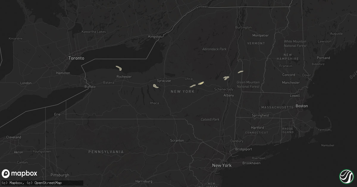
Hail Map in New York on September 19, 2022
Get this storm
September 19 map
$229
one time, instant access
Download today. No call, no setup
Keep the $229
Bought the map and want the full workflow? Apply the entire $229 to a subscription within 7 days. None of it is wasted.
Every map, not just this one
This buys you this map. Subscription and you get every map we run, in the markets you choose from a few cities to whole states to nationwide. Plus real-time alerts the moment a storm fires.
Contact data
Name, contact info, occupancy, even credit band for addresses in the footprint. You go from where it hit to who to call.
Become the source they trust
Unlimited branding weather history reports on demand. You already have the documented answer ready for the property owner, and you are the one who showed up with it.
Property data and RoofTrace estimates
Pull up any address you have got, its value and the exact code rules for that jurisdiction, straight from One Click Code. Then RoofTrace estimates the squares, pitch, and roof value, priced the way you price.
Storm reports in New York
New York
| Date | Description |
|---|---|
| 09/19/20226:30 PM CDT | Trees and wires down. Some village residents without power. Relayed from fire chief by em. |
| 09/19/20224:41 PM CDT | Downed trees at the intersection of west dover road and hoags corner road |
| 09/19/20222:37 PM CDT | Trees and wires down on cary road in fort edward |
| 09/19/20222:18 PM CDT | Wires down on 3105 route 9n. |
| 09/19/20222:14 PM CDT | Tree downed in northville |
| 09/19/20222:14 PM CDT | Tree downed in northampton |
| 09/19/20221:48 PM CDT | Tree down on a trailer at 100 gordon lane |
| 09/19/20221:35 PM CDT | Hail up to the size of quarters at northway exit 16 |
| 09/19/20221:24 PM CDT | Wires down on intersection of wilton rd and brigham rd. Brigham rd was closed due to down wires. |
| 09/19/202212:59 PM CDT | Trees and wires down along route 20 west of west winfield |
| 09/18/202210:59 PM CDT | At 358 PM EDT, severe thunderstorms were located along a line extending from near Sharon Springs to near Summit to Stamford, moving east at 50 mph. HAZARD...60 mph wind gusts. SOURCE...Radar indicated. IMPACT...Expect damage to roofs, siding, and trees. Locations impacted include... Cobleskill, Jefferson, Middleburgh, Gilboa, Summit, Schoharie, Richmondville, Livingstonville, North Blenheim, Breakabeen, Central Bridge, Preston-Potter Hollow, Seward, Conesville, Zeh Corners, West Richmondville, Baird Corners, West Berne, Huntersland and Warnerville. |
| 09/18/202210:00 PM CDT | At 259 PM EDT, a severe thunderstorm was located 7 miles northwest of Cranberry Creek, or 11 miles north of Gloversville, moving east at 55 mph. HAZARD...60 mph wind gusts and penny size hail. SOURCE...Radar indicated. IMPACT...Expect damage to roofs, siding, and trees. Locations impacted include... Northville, Day Center, Sacandaga Campground, Hope, Benson, West Day, Hope Falls, Tenantville, Pinnacle, Maple Grove, Lake View, Clarkville, Tomantown, Upper Benson and Peters Corners. |
| 09/18/20229:45 PM CDT | At 245 PM EDT, a severe thunderstorm was located over St. Johnsville, or 9 miles northwest of Canajoharie, moving east at 30 mph. HAZARD...60 mph wind gusts and penny size hail. SOURCE...Radar indicated. IMPACT...Expect damage to roofs, siding, and trees. Locations impacted include... Gloversville, Johnstown, Fonda, Fort Plain, St. Johnsville, Ephratah, Broadalbin, Hagaman, Edinburg, Mayfield, Fort Johnson, Galway, Cranberry Creek, Northampton Beach Public Campground, Caroga Lake, Caroga Lake Public Campground, Tribes Hill, Mount Pleasant, Perth and Oppenheim. |
| 09/18/20229:05 PM CDT | At 204 PM EDT, a severe thunderstorm was located near Saratoga Springs, moving northeast at 20 mph. HAZARD...60 mph wind gusts and quarter size hail. SOURCE...Radar indicated. IMPACT...Hail damage to vehicles is expected. Expect wind damage to roofs, siding, and trees. Locations impacted include... Saratoga Springs, Hudson Falls, Salem, Fort Edward, Rock City Falls, Kings, Gates, Wilton, Greenfield, Northumberland, South Glens Falls, Schuylerville, Argyle, Cossayuna, Dunham Basin, Smiths Basin, Goose Island, Adamsville, Grangerville and Kings Station. |
| 09/18/20228:54 PM CDT | At 154 PM EDT, a severe thunderstorm was located over West Winfield, or 10 miles southwest of Ilion, moving east at 35 mph. HAZARD...60 mph wind gusts and quarter size hail. SOURCE...Radar indicated. IMPACT...Hail damage to vehicles is expected. Expect wind damage to roofs, siding, and trees. Locations impacted include... Canajoharie, Fort Plain, St. Johnsville, West Winfield, Ames, Jordanville, Cedarville, Elizabethtown, Warren, Palatine Bridge, Nelliston, Jersalem Hill, Spinnerville, Cedar Lake, South Columbia, Mindenville, Davys Corners, Chepachet, Ripple Corners and Columbia Center. |
All States Impacted by Hail Map on September 19, 2022
Cities Impacted by Hail Map on September 19, 2022
- Chetek, WI
- New Auburn, WI
- Barronett, WI
- Cumberland, WI
- Shell Lake, WI
- Sarona, WI
- Rice Lake, WI
- Luverne, ND
- Fremont, WI
- Pine River, WI
- Donna, TX
- Weyauwega, WI
- Waupaca, WI
- Mandan, ND
- Center, ND
- Mcville, ND
- Pekin, ND
- Spencer, WI
- New Rockford, ND
- Warwick, ND
- Tolna, ND
- Cathay, ND
- Mchenry, ND
- Bloomer, WI
- Cameron, WI
- Bruce, WI
- Weyerhaeuser, WI
- Barron, WI
- Bismarck, ND
- Moffit, ND
- Hazelton, ND
- Menoken, ND
- Aneta, ND
- Bancroft, WI
- Stevens Point, WI
- Junction City, WI
- Plover, WI
- Amherst, WI
- Hilton, NY
- Courtenay, ND
- Dazey, ND
- Wimbledon, ND
- Hannaford, ND
- Owen, WI
- Unity, WI
- Greenwood, WI
- Loyal, WI
- Saratoga Springs, NY
- Middle Grove, NY
- Greenfield Center, NY
- Colfax, WI
- Wisconsin Rapids, WI
- Custer, WI
- Almond, WI
- Nelsonville, WI
- Amherst Junction, WI
- Scandinavia, WI
- Carrington, ND
- Withee, WI
- Winneconne, WI
- Oshkosh, WI
- Larsen, WI
- Fort Plain, NY
- Mohawk, NY
- Little Falls, NY
- Jordanville, NY
- Saint Johnsville, NY
- Skaneateles, NY
- Auburn, NY
- Boyceville, WI
- Wheeler, WI
- Stanley, WI
- Thorp, WI
- Napoleon, ND
- Streeter, ND
- Gackle, ND
- Milltown, WI
- Luck, WI
- Ilion, NY
- Richfield Springs, NY
- West Winfield, NY
- Alma Center, WI
- Hixton, WI
- Tony, WI
- Ladysmith, WI
- Glen Flora, WI
- Pingree, ND
- Buchanan, ND
- Dallas, WI
- Prairie Farm, WI
- Kintyre, ND
- Braddock, ND
- Jud, ND
- Saint Croix Falls, WI
- Centuria, WI
- Cornell, WI
- Cadott, WI
- Colby, WI
- Jim Falls, WI
- Ridgeland, WI
- New Salem, ND
- Ballston Spa, NY
- Porter Corners, NY
- Salem, NY
- Argyle, NY
- Granville, NY
- West Pawlet, VT
- Boyd, WI
- Fredonia, ND
- Syracuse, KS
- Clayton, WI
- Conrath, WI
- Comstock, WI
- Gansevoort, NY
- Rock City Falls, NY
- Chippewa Falls, WI
- Augusta, WI
- Sykeston, ND
- Saint Anthony, ND


