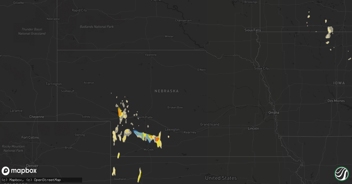
Hail Map in Nebraska on September 19, 2019
Get this storm
September 19 map
$229
one time, instant access
Download today. No call, no setup
Keep the $229
Bought the map and want the full workflow? Apply the entire $229 to a subscription within 7 days. None of it is wasted.
Every map, not just this one
This buys you this map. Subscription and you get every map we run, in the markets you choose from a few cities to whole states to nationwide. Plus real-time alerts the moment a storm fires.
Contact data
Name, contact info, occupancy, even credit band for addresses in the footprint. You go from where it hit to who to call.
Become the source they trust
Unlimited branding weather history reports on demand. You already have the documented answer ready for the property owner, and you are the one who showed up with it.
Property data and RoofTrace estimates
Pull up any address you have got, its value and the exact code rules for that jurisdiction, straight from One Click Code. Then RoofTrace estimates the squares, pitch, and roof value, priced the way you price.
Storm reports in Nebraska
Nebraska
| Date | Description |
|---|---|
| 09/19/20195:42 PM CDT | A local report indicates 1.75 inch wind near 5 ESE STOCKVILLE |
| 09/19/20195:39 PM CDT | Estimated wind gust at this location along with pea sized hail. |
| 09/19/20195:30 PM CDT | A local report indicates 1.75 inch wind near 1 S STOCKVILLE |
| 09/19/20194:16 AM CDT | At 916 PM CDT/816 PM MDT/, a severe thunderstorm was located near Elsie, or 15 miles east of Grant, moving north at 25 mph. HAZARD...60 mph wind gusts and quarter size hail. SOURCE...Radar indicated. IMPACT...Hail damage to vehicles is expected. Expect wind damage to roofs, siding, and trees. Locations impacted include... Ogallala, Paxton, Madrid, Elsie, Sarben, Roscoe and Grainton. This includes the following highways... Highway 61 between mile markers 55 and 56, between mile markers 63and 64, and between mile markers 77 and 92. Interstate 80 in Nebraska between mile markers 124 and 154. |
| 09/19/20192:39 AM CDT | At 739 PM CDT, a severe thunderstorm was located 9 miles south of Wellfleet, or 14 miles northeast of Hayes Center, moving northwest at 15 mph. HAZARD...60 mph wind gusts and quarter size hail. SOURCE...Radar indicated. IMPACT...Hail damage to vehicles is expected. Expect wind damage to roofs, siding, and trees. Locations impacted include... Wellfleet, Dickens, Maywood, Marengo, Hayes Center State Wildlife Management Area and Somerset.This includes Highway 83 between mile markers 43 and 63. |
| 09/19/20192:08 AM CDT | At 708 PM MDT, a severe thunderstorm was located near Kingsley Dam, or 9 miles north of Ogallala, moving north at 35 mph. HAZARD...60 mph wind gusts and half dollar size hail. SOURCE...Law enforcement. IMPACT...Hail damage to vehicles is expected. Expect wind damage to roofs, siding, and trees. Locations impacted include... Arthur, Lemoyne, Keystone, Kingsley Dam, Haythorn Lake, Velma and McKeag.This includes the following highways... Highway 61 between mile markers 95 and 129. Highway 92 between mile markers 131 and 175. |
| 09/19/20191:54 AM CDT | At 653 PM CDT, severe thunderstorms were located along a line extending from near Stockville to 10 miles east of Hayes Center, moving north at 20 mph. HAZARD...60 mph wind gusts and quarter size hail. SOURCE...Radar indicated. IMPACT...Hail damage to vehicles is expected. Expect wind damage to roofs, siding, and trees. Locations impacted include... Curtis, Hayes Center, Wellfleet, Moorefield, Stockville, Dickens, Maywood, Hansen Memorial Reserve State Wildlife Management Area, Jeffrey Canyon State Wildlife Management Area, Hayes Center State Wildlife Management Area, Marengo, Orafino, Vroman, Somerset and Dancing Leaf Earth Lodge.This includes the following highways... Interstate 80 in Nebraska between mile markers 204 and 207. Highway 83 between mile markers 33 and 69. |
| 09/19/20191:09 AM CDT | At 609 PM CDT, a severe thunderstorm was located near Curtis, moving north at 20 mph. HAZARD...60 mph wind gusts and quarter size hail. SOURCE...Radar indicated. IMPACT...Hail damage to vehicles is expected. Expect wind damage to roofs, siding, and trees. Locations impacted include... Curtis, Moorefield, Stockville, Maywood, Hansen Memorial Reserve State Wildlife Management Area, Orafino and Dancing Leaf Earth Lodge. |
| 09/19/201912:26 AM CDT | At 525 PM CDT, a severe thunderstorm was located near Medicine Creek Reservoir State Recreation Area, or 18 miles southeast of Curtis, moving north at 20 mph. HAZARD...60 mph wind gusts and quarter size hail. SOURCE...Radar indicated. IMPACT...Hail damage to vehicles is expected. Expect wind damage to roofs, siding, and trees. Locations impacted include... Curtis, Moorefield, Stockville, Medicine Creek Reservoir State Recreation Area, Orafino, Freedom and Dancing Leaf Earth Lodge. |
| 09/19/201912:20 AM CDT | At 520 PM CDT, a severe thunderstorm was located over Elwood, or 13 miles southwest of Lexington, moving north at 10 mph. HAZARD...60 mph wind gusts and quarter size hail. SOURCE...Radar indicated. IMPACT...Hail damage to vehicles is expected. Expect wind damage to roofs, siding, and trees. Locations impacted include... Elwood, Smithfield and Johnson Lake. This includes Interstate 80 between mile markers 236 and 240. |
| 09/18/20198:30 PM CDT | Asos station kiml imperial airport. This is a corrected lsr. |
| 09/18/20198:22 PM CDT | Pws station |
| 09/18/20198:05 PM CDT | Report relayed from dispatch center. |
| 09/18/20197:00 PM CDT | Gusts around 50 to 60 mph. Report via social media. |
| 09/18/20197:00 PM CDT | A local report indicates 1.00 inch wind near 11 ENE HAYES CENTER |
| 09/18/20197:00 PM CDT | A local report indicates 1.00 inch wind near 13 NE HAYES CENTER |
All States Impacted by Hail Map on September 19, 2019
Cities Impacted by Hail Map on September 19, 2019
- Parks, NE
- Lockney, TX
- Imperial, NE
- Champion, NE
- Venango, NE
- Stockville, NE
- Moorefield, NE
- Panhandle, TX
- Elwood, NE
- Forman, ND
- Gwinner, ND
- New London, MO
- Dimmitt, TX
- Fortuna, ND
- Hereford, TX
- Adrian, TX
- Wallace, NE
- Bartley, NE
- Cambridge, NE
- Hayes Center, NE
- Maywood, NE
- Farnam, NE
- Eustis, NE
- Dickens, NE
- Curtis, NE
- Saint Francis, KS
- Kanorado, KS
- Goodland, KS
- Roaring Springs, TX
- Floydada, TX
- Miami, TX
- Calvin, ND
- Kress, TX
- Tulia, TX
- Moulton, TX
- Shiner, TX
- Canyon, TX
- Delavan, MN
- Amarillo, TX
- Aspermont, TX
- White Deer, TX
- Dunseith, ND
- Newhall, IA
- Vinton, IA
- Van Horne, IA
- Edina, MO
- Crosby, TX
- Schertz, TX
- Cibolo, TX
- Dalhart, TX
- Havana, ND
- Helena, AR
- Dundee, MS
- Vega, TX
- Masterson, TX
- Dumas, TX
- Channing, TX
- Britton, SD
- Ewing, MO
- La Belle, MO
- Lewistown, MO
- Colby, KS
- Hershey, NE
- Holly, CO
- Claude, TX
- Doddsville, MS
- Elsie, NE
- Happy, TX
- Clutier, IA
- Toledo, IA
- Grant, NE
- Haigler, NE
- Metamora, IL
- Wauneta, NE
- Madrid, NE
- Fingal, ND
- Enderlin, ND
- Sheldon, ND
- Lisbon, ND
- Canadian, TX
- Ogallala, NE
- Keystone, NE
- Lemoyne, NE
- Granada, MN
- Fairmont, MN
- Wayside, TX
- Arthur, NE
- Scott City, KS
- Sutherland, NE
- Garner, IA
- Britt, IA
- Tribune, KS
- Saint James, MN
- Clovis, NM
- Ridgeland, MS
- Madison, MS
- Brandon, MS
- Leoti, KS
- Hartley, TX
- Sunflower, MS
- Woden, IA
- Buffalo Center, IA
- Paxton, NE
- Wellfleet, NE
- Enders, NE
- Old Glory, TX
- Kalona, IA
- Wellman, IA
- Bricelyn, MN
- Muleshoe, TX
- Keyes, OK
- Rockwell, IA
- Wyoming, IL
- Rolla, ND
- Silverton, TX
- Keystone, IA
- Portales, NM
- Saint John, ND
- Syracuse, KS
- Buckingham, IA
- Scarville, IA
- Kanawha, IA
- Frost, MN
- Thompson, IA
- Atwood, KS
- Hallettsville, TX
- Oxford, IA
- McCook, NE
- Milnor, ND
- Friona, TX
- Groom, TX
- Marienthal, KS
- Titonka, IA
- Houston, TX
- Knox City, MO
- Seguin, TX
- Marion, TX
- Saint Hedwig, TX
- Converse, TX
- Healy, KS
- Sheridan Lake, CO
- Williamsburg, IA
- Elberon, IA
- Hankamer, TX
- Anahuac, TX
- Deerfield, KS
- Novelty, MO
- San Antonio, TX
- Sherburn, MN
- Blue Earth, MN
- Kiester, MN
- Wells, MN
- La Fayette, IL
- Gonzales, TX
- Hampton, IA
- Ashby, NE
- Speer, IL
- Mico, TX
- Cleveland, MS
- Ruleville, MS
- Munich, ND
- Turpin, OK
- Parnell, IA
- Hansboro, ND
- Plainview, TX
- Page, ND
- Trimont, MN
- Hopkinton, IA
- Leesville, TX
- Walsh, CO
- Ambrose, ND
- Marengo, IA
- Johnson, KS
- Medina, TX
- Pipe Creek, TX
- Stinnett, TX
- Borger, TX
- Jbsa Randolph, TX
- Jbsa Ft Sam Houston, TX
- Brockton, MT
- Froid, MT
- Sharon Springs, KS
- Gem, KS


