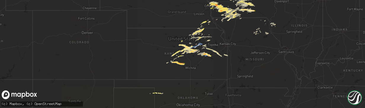
Hail Map in Kansas on September 17, 2022
The weather event in Kansas on September 17, 2022 includes Wind and Hail maps. 11 states and 390 cities were impacted and suffered possible damage. The total estimated number of properties impacted is 32,629.
Want more than just the map?
Turn this storm into a full workflow.
- Owner + property data so you know who to knock
- OnDemand branded weather history reports to win the "did we even have hail?" argument
- RoofTrace estimate so reps stop guessing numbers at the door
Bought this map? Upgrade within 7 days and we'll credit the $230. (10-15 min setup call)
Wind
Hail
32,629
Estimated number of impacted properties by a 1.00" hail or larger6,714
Estimated number of impacted properties by a 1.75" hail or larger783
Estimated number of impacted properties by a 2.50" hail or largerStorm reports in Kansas
Kansas
| Date | Description |
|---|---|
| 09/17/20226:59 PM CDT | A local report indicates 1.00 inch wind near 4 W MARYSVILLE |
| 09/17/20226:30 PM CDT | A local report indicates 1.50 inch wind near LINCOLN |
| 09/17/20224:40 PM CDT | A local report indicates 1.00 inch wind near 3 N NEOSHO RAPIDS |
| 09/17/20224:40 PM CDT | Trees stripped of their leaves. |
| 09/17/20224:30 PM CDT | Estimated wind speed. Tree limbs and power lines are down and blocking roads. |
| 09/17/20224:21 PM CDT | A local report indicates 1.75 inch wind near 4 NW NEOSHO RAPIDS |
| 09/17/20224:07 PM CDT | A local report indicates 1.00 inch wind near 4 NNE EMPORIA |
| 09/17/20224:05 PM CDT | Kemp. |
| 09/17/20224:03 PM CDT | Asos station kemp emporia. |
| 09/17/20224:02 PM CDT | Lot of tree limbs and power lines down. One house had tree fall onto roof. Estimated wind gusts of 65 mph. |
| 09/17/20223:52 PM CDT | Lots of tree limb damage and a few small trees |
| 09/17/20223:30 PM CDT | Delayed report. Reported numerous large hail stones with quarter being the largest observed. Wind was up to 40 mph. |
| 09/17/20223:21 PM CDT | A local report indicates 2.00 inch wind near AMERICUS |
| 09/17/20223:16 PM CDT | Hailed for the past 15 minutes and hail covers the deck. |
| 09/17/20223:10 PM CDT | Spotter had winds of 40 to 60 mph which flattened the bushes and hedges as it was moving across. Pea to dime sized hail occurred as well. Time is estimated from radar. |
| 09/17/20223:00 PM CDT | Delayed report: barn damage... Trees down... Dog house destroyed. |
| 09/17/20221:05 PM CDT | A local report indicates 1.00 inch wind near 3 NNW WILSEY |
| 09/17/20226:55 AM CDT | At 1154 PM CDT, severe thunderstorms were located along a line extending from 3 miles southeast of Talmage to Ramona, moving east at 20 mph. HAZARD...60 mph wind gusts and half dollar size hail. SOURCE...Radar indicated. IMPACT...Hail damage to vehicles is expected. Expect wind damage to roofs, siding, and trees. Locations impacted include... Junction City, Abilene, Herington, Grandview Plaza, Chapman, Enterprise, White City, Hope, Woodbine, Wilsey, Latimer, Talmage, Moonlight and Burdick.This includes Interstate 70 between mile markers 271 and 299.This warning replaces the two warnings currently in effect for Dickinson County. |
| 09/17/20226:37 AM CDT | At 1137 PM CDT, a severe thunderstorm was located 5 miles north of Carlton, moving east at 20 mph. HAZARD...60 mph wind gusts and quarter size hail. SOURCE...Radar indicated. IMPACT...Hail damage to vehicles is expected. Expect wind damage to roofs, siding, and trees. Locations impacted include... Abilene and Enterprise. |
| 09/17/20226:11 AM CDT | At 1111 PM CDT, a severe thunderstorm was located 5 miles south of Carlton, moving east at 20 mph. HAZARD...60 mph wind gusts and half dollar size hail. SOURCE...Radar indicated. IMPACT...Hail damage to vehicles is expected. Expect wind damage to roofs, siding, and trees. Locations impacted include... Hope and Carlton. |
| 09/17/20225:04 AM CDT | At 1004 PM CDT, a severe thunderstorm was located 6 miles southeast of Ogden, moving east at 30 mph. HAZARD...70 mph wind gusts and penny size hail. SOURCE...Trained weather spotters. IMPACT...Expect considerable tree damage. Damage is likely to mobile homes, roofs, and outbuildings. Locations impacted include... Southern Manhattan and Ogden. This includes Interstate 70 between mile markers 306 and 316. |
| 09/17/20224:54 AM CDT | At 954 PM CDT, a severe thunderstorm was located near Marysville, moving east at 30 mph. HAZARD...60 mph wind gusts and quarter size hail. SOURCE...Radar indicated. IMPACT...Hail damage to vehicles is expected. Expect wind damage to roofs, siding, and trees. Locations impacted include... Marysville, Beattie and Summerfield. |
| 09/17/20224:50 AM CDT | At 949 PM CDT, a severe thunderstorm was located 4 miles east of Ogden, moving northeast at 50 mph. HAZARD...70 mph wind gusts. SOURCE...Trained weather spotters. This storm has produced some strong wind gusts in and around Junction City. IMPACT...Expect considerable tree damage. Damage is likely to mobile homes, roofs, and outbuildings. Locations impacted include... Northeastern Manhattan, Wamego, St. Marys, St. George, Belvue and Louisville.This includes Interstate 70 between mile markers 317 and 323. |
| 09/17/20224:35 AM CDT | At 934 PM CDT, a severe thunderstorm was located near Junction City, moving northeast at 45 mph. HAZARD...70 mph wind gusts. SOURCE...Radar indicated. IMPACT...Expect considerable tree damage. Damage is likely to mobile homes, roofs, and outbuildings. Locations impacted include... Manhattan, Junction City, Ogden and Grandview Plaza. This includes Interstate 70 between mile markers 297 and 318. |
| 09/17/20224:32 AM CDT | At 932 PM CDT, a severe thunderstorm was located over Marquette, or 10 miles west of Lindsborg, moving east at 10 mph. HAZARD...Ping pong ball size hail and 60 mph wind gusts. SOURCE...Radar indicated. IMPACT...People and animals outdoors will be injured. Expect hail damage to roofs, siding, windows, and vehicles. Expect wind damage to roofs, siding, and trees. Locations impacted include... Lindsborg, Marquette, Assaria, Gypsum, Falun, Bridgeport and Roxbury.This includes Interstate 135 between Mile Markers 65 and 86. |
| 09/17/20224:13 AM CDT | At 912 PM CDT, severe thunderstorms were located along a line extending from near Abilene to 6 miles northeast of Carlton, moving east at 30 mph. HAZARD...70 mph wind gusts and quarter size hail. SOURCE...Radar indicated. These storms have a history of producing wind gusts between 60 and 80 MPH. IMPACT...Hail damage to vehicles is expected. Expect considerable tree damage. Wind damage is also likely to mobile homes, roofs, and outbuildings. Locations impacted include... Junction City, Abilene, Herington, Chapman, Enterprise, Hope, Woodbine, Latimer and Moonlight.This includes Interstate 70 between mile markers 274 and 297. |
| 09/17/20223:45 AM CDT | At 845 PM CDT, a severe thunderstorm was located over Arlington, or 12 miles northwest of Pretty Prairie, moving east at 20 mph. HAZARD...Golf ball size hail and 70 mph wind gusts. SOURCE...Radar indicated. IMPACT...People and animals outdoors will be injured. Expect hail damage to roofs, siding, windows, and vehicles. Expect considerable tree damage. Wind damage is also likely to mobile homes, roofs, and outbuildings. Locations impacted include... Hutchinson, South Hutchinson, Haven, Pretty Prairie, Arlington, Partridge, Abbyville, Yoder, Cheney Lake and Cheney State Park. |
| 09/17/20223:29 AM CDT | At 828 PM CDT, a severe thunderstorm was located over New Cambria, moving east at 20 mph. HAZARD...Golf ball size hail and 60 mph wind gusts. SOURCE...Trained weather spotters. This storm has produced golf ball sized hail in near New Cambria. IMPACT...People and animals outdoors will be injured. Expect hail damage to roofs, siding, windows, and vehicles. Expect wind damage to roofs, siding, and trees. Locations impacted include... Abilene, Solomon and Carlton. This includes Interstate 70 between mile markers 267 and 277. |
| 09/17/20223:25 AM CDT | At 825 PM CDT, a severe thunderstorm was located near Brookville, or 9 miles west of Salina, moving northeast at 45 mph. HAZARD...60 mph wind gusts and half dollar size hail. SOURCE...Radar indicated. IMPACT...Hail damage to vehicles is expected. Expect wind damage to roofs, siding, and trees. Locations impacted include... Salina, Assaria, Gypsum, Brookville, Smolan, New Cambria, Falun, Bridgeport, Salina Airport and Kipp.This includes the following highways... Interstate 135 between Mile Markers 77 and 95. Interstate 70 between Mile Markers 251 and 253. |
| 09/17/20223:02 AM CDT | At 802 PM CDT, a severe thunderstorm was located near Little River, or 6 miles northeast of Lyons, moving northeast at 35 mph. HAZARD...60 mph wind gusts and quarter size hail. SOURCE...Public. IMPACT...Hail damage to vehicles is expected. Expect wind damage to roofs, siding, and trees. Locations impacted include... Mcpherson, Lindsborg, Marquette, Little River, Windom and Mcpherson Airport.This includes Interstate 135 between Mile Markers 56 and 76. |
| 09/17/20222:47 AM CDT | At 747 PM CDT, a severe thunderstorm was located near Sylvia, or near Zenith, moving east at 35 mph. HAZARD...60 mph wind gusts and half dollar size hail. SOURCE...Radar indicated. IMPACT...Hail damage to vehicles is expected. Expect wind damage to roofs, siding, and trees. Locations impacted include... Hutchinson, South Hutchinson, Inman, Buhler, Haven, Nickerson, Arlington, Partridge, Sylvia, Plevna, Abbyville, Yoder, Willowbrook and Hutchinson Airport. |
| 09/17/20222:43 AM CDT | At 742 PM CDT, a severe thunderstorm was located near Linn, moving northeast at 20 mph. HAZARD...60 mph wind gusts and quarter size hail. SOURCE...Radar indicated. This storms has a history of producing 60 mph winds. IMPACT...Hail damage to vehicles is expected. Expect wind damage to roofs, siding, and trees. Locations impacted include... Greenleaf and Barnes. |
| 09/17/20222:42 AM CDT | At 742 PM CDT, a severe thunderstorm was located over Lorraine, or 10 miles northeast of Claflin, moving northeast at 35 mph. HAZARD...Ping pong ball size hail and 60 mph wind gusts. SOURCE...Radar indicated. IMPACT...People and animals outdoors will be injured. Expect hail damage to roofs, siding, windows, and vehicles. Expect wind damage to roofs, siding, and trees. Locations impacted include... Ellsworth, Kanopolis, Holyrood, Bushton, Geneseo, Lorraine, Frederick, Kanopolis Lake, Kanopolis State Park and Ellsworth Airport.This includes Interstate 70 between Mile Markers 225 and 228. |
| 09/17/20222:38 AM CDT | At 737 PM CDT, a severe thunderstorm was located near Culver, moving east at 15 mph. HAZARD...Golf ball size hail and 70 mph wind gusts. SOURCE...Trained weather spotters. This storm has a history of producing large hail in Tescott. IMPACT...People and animals outdoors will be injured. Expect hail damage to roofs, siding, windows, and vehicles. Expect considerable tree damage. Wind damage is also likely to mobile homes, roofs, and outbuildings. Locations impacted include... Bennington, Tescott, Culver and Niles. |
| 09/17/20222:33 AM CDT | At 733 PM CDT, a severe thunderstorm was located near Tescott, or 15 miles southeast of Lincoln, moving east at 20 mph. HAZARD...60 mph wind gusts and half dollar size hail. SOURCE...Radar indicated. IMPACT...Hail damage to vehicles is expected. Expect wind damage to roofs, siding, and trees. Locations impacted include... Salina, Beverly, New Cambria and Glendale. This includes the following highways... Interstate 135 between Mile Markers 93 and 95. Interstate 70 between Mile Markers 235 and 266. |
| 09/17/20222:28 AM CDT | At 728 PM CDT, a severe thunderstorm was located near Marysville, moving northeast at 30 mph. HAZARD...60 mph wind gusts and quarter size hail. SOURCE...Radar indicated. IMPACT...Hail damage to vehicles is expected. Expect wind damage to roofs, siding, and trees. Locations impacted include... Marysville, Axtell and Beattie. |
| 09/17/20222:27 AM CDT | At 727 PM CDT, a severe thunderstorm was located near Stafford, moving east at 25 mph. HAZARD...Quarter size hail. SOURCE...Radar indicated. IMPACT...Damage to vehicles is expected. This severe thunderstorm will be near... Zenith around 745 PM CDT. |
| 09/17/20222:26 AM CDT | Measured 2.21 inches of rainfall. |
| 09/17/20222:20 AM CDT | At 720 PM CDT, a severe thunderstorm was located over Palmer, moving east at 35 mph. HAZARD...60 mph wind gusts and quarter size hail. SOURCE...Radar indicated. IMPACT...Hail damage to vehicles is expected. Expect wind damage to roofs, siding, and trees. Locations impacted include... Linn, Greenleaf, Barnes and Palmer. |
| 09/17/20222:03 AM CDT | At 703 PM CDT, a severe thunderstorm was located near Great Bend, moving northeast at 25 mph. HAZARD...Ping pong ball size hail and 60 mph wind gusts. SOURCE...Radar indicated. IMPACT...People and animals outdoors will be injured. Expect hail damage to roofs, siding, windows, and vehicles. Expect wind damage to roofs, siding, and trees. Locations impacted include... Great Bend, Ellinwood, Claflin, Chase, Holyrood, Bushton, Cheyenne Bottoms, Silica and Odin. |
| 09/17/20221:56 AM CDT | At 656 PM CDT, a severe thunderstorm was located near Marysville, moving east at 25 mph. HAZARD...60 mph wind gusts and quarter size hail. SOURCE...Radar indicated. IMPACT...Hail damage to vehicles is expected. Expect wind damage to roofs, siding, and trees. Locations impacted include... Marysville and Oketo. |
| 09/17/20221:54 AM CDT | At 654 PM CDT, a severe thunderstorm was located over Beverly, moving east at 15 mph. HAZARD...Ping pong ball size hail and 60 mph wind gusts. SOURCE...Radar indicated. IMPACT...People and animals outdoors will be injured. Expect hail damage to roofs, siding, windows, and vehicles. Expect wind damage to roofs, siding, and trees. Locations impacted include... Minneapolis, Tescott and Culver. |
| 09/17/20221:40 AM CDT | At 639 PM CDT, a severe thunderstorm was located 7 miles southwest of Glasco, or 15 miles northwest of Minneapolis, moving northeast at 30 mph. HAZARD...Half dollar size hail. SOURCE...Radar indicated. IMPACT...Damage to vehicles is expected. Locations impacted include... Rural areas of far southeast Mitchell county. |
| 09/17/20221:32 AM CDT | At 632 PM CDT, a severe thunderstorm was located 4 miles north of Barnes, moving east at 25 mph. HAZARD...60 mph wind gusts and quarter size hail. SOURCE...Radar indicated. IMPACT...Hail damage to vehicles is expected. Expect wind damage to roofs, siding, and trees. Locations impacted include... Marysville, Blue Rapids, Waterville, Barnes and Bremen. |
| 09/17/20221:30 AM CDT | At 630 PM CDT, a severe thunderstorm was located over Lincoln, moving east at 25 mph. Golf ball sized hail has been reported with this storm. HAZARD...Two inch hail and 70 mph wind gusts. SOURCE...Law enforcement. IMPACT...People and animals outdoors will be injured. Expect hail damage to roofs, siding, windows, and vehicles. Expect considerable tree damage. Wind damage is also likely to mobile homes, roofs, and outbuildings. Locations impacted include... Lincoln, Beverly, Barnard and Westfall. |
| 09/17/20221:24 AM CDT | At 624 PM CDT, a severe thunderstorm was located over Lincoln, moving northeast at 20 mph. HAZARD...Golf ball size hail and 70 mph wind gusts. SOURCE...Radar indicated. IMPACT...People and animals outdoors will be injured. Expect hail damage to roofs, siding, windows, and vehicles. Expect considerable tree damage. Wind damage is also likely to mobile homes, roofs, and outbuildings. Locations impacted include... Lincoln, Beverly, Barnard and Westfall. |
| 09/16/202211:38 PM CDT | At 438 PM CDT, a severe thunderstorm was located near Neosho Rapids, moving southeast at 15 mph. HAZARD...Two inch hail and 60 mph wind gusts. SOURCE...Radar indicated. IMPACT...People and animals outdoors will be injured. Expect hail damage to roofs, siding, windows, and vehicles. Expect wind damage to roofs, siding, and trees. Locations impacted include... Lebo, Hartford, Neosho Rapids, Reading and Beto Junction. This includes Interstate 35 between mile markers 137 and 158. |
| 09/16/202211:18 PM CDT | At 417 PM CDT, a severe thunderstorm was located 7 miles southwest of Reading, moving east at 15 mph. HAZARD...Two inch hail and 60 mph wind gusts. SOURCE...Radar indicated. IMPACT...People and animals outdoors will be injured. Expect hail damage to roofs, siding, windows, and vehicles. Expect wind damage to roofs, siding, and trees. Locations impacted include... Lebo, Hartford, Neosho Rapids and Reading. This includes the following highways... Interstate 35 between mile markers 138 and 149. Kansas Turnpike between mile markers 142 and 144. |
| 09/16/202211:13 PM CDT | At 412 PM CDT, a severe thunderstorm was located 4 miles northeast of Emporia, moving east at 10 mph. HAZARD...60 mph wind gusts and quarter size hail. SOURCE...Radar indicated. At 4:05pm, a 59mph wind gusts was measured at the Emporia Airport. IMPACT...Hail damage to vehicles is expected. Expect wind damage to roofs, siding, and trees. This severe thunderstorm will remain over mainly rural areas of southeastern Lyon County. |
| 09/16/202211:05 PM CDT | At 404 AM CDT, a severe thunderstorm was located near Republic, moving northeast at 20 mph. HAZARD...60 mph wind gusts and half dollar size hail. SOURCE...Radar indicated. IMPACT...Hail damage to vehicles is expected. Expect wind damage to roofs, siding, and trees. Locations impacted include... Republic. |
| 09/16/202210:56 PM CDT | At 355 PM CDT, a severe thunderstorm was located 4 miles southeast of Americus, moving east at 10 mph. HAZARD...Two inch hail and 70 mph wind gusts. SOURCE...Radar indicated. IMPACT...People and animals outdoors will be injured. Expect hail damage to roofs, siding, windows, and vehicles. Expect considerable tree damage. Wind damage is also likely to mobile homes, roofs, and outbuildings. Locations impacted include... Emporia and Americus. This includes the following highways... Interstate 35 between mile markers 128 and 138. Kansas Turnpike between mile markers 123 and 142. |
| 09/16/202210:43 PM CDT | At 343 PM CDT, a severe thunderstorm was located near Emporia, moving east at 30 mph. HAZARD...60 mph wind gusts and quarter size hail. SOURCE...Radar indicated. IMPACT...Hail damage to vehicles is expected. Expect wind damage to roofs, siding, and trees. Locations impacted include... Emporia.This includes Kansas Turnpike between mile markers 118 and 124. |
| 09/16/202210:25 PM CDT | At 324 PM CDT, a severe thunderstorm was located 4 miles south of Americus, moving northeast at 25 mph. HAZARD...70 mph wind gusts and ping pong ball size hail. SOURCE...Radar indicated. IMPACT...People and animals outdoors will be injured. Expect hail damage to roofs, siding, windows, and vehicles. Expect considerable tree damage. Wind damage is also likely to mobile homes, roofs, and outbuildings. Locations impacted include... Emporia and Americus. This includes the following highways... Interstate 35 between mile markers 128 and 138. Kansas Turnpike between mile markers 124 and 141. |
| 09/16/202210:03 PM CDT | A local report indicates 1.50 inch wind near 2 E MARYSVILLE |
| 09/16/20229:56 PM CDT | At 255 PM CDT, a severe thunderstorm was located near Americus, moving east at 35 mph. HAZARD...60 mph wind gusts and half dollar size hail. SOURCE...Radar indicated. IMPACT...Hail damage to vehicles is expected. Expect wind damage to roofs, siding, and trees. Locations impacted include... Americus, Allen, Admire and Dunlap. This includes Kansas Turnpike between mile markers 129 and 143. |
| 09/16/20229:55 PM CDT | Ksu mesonet. |
| 09/16/20229:55 PM CDT | Asos station kmhk manhattan. |
| 09/16/20229:40 PM CDT | A local report indicates 70 MPH wind near 2 S GRANDVIEW PLAZA |
| 09/16/20229:39 PM CDT | Sign blown down on us highway 77. |
| 09/16/20229:36 PM CDT | Corrects previous hail report from marquette. Received through social media. |
| 09/16/20229:36 PM CDT | Received through social media. |
| 09/16/20229:35 PM CDT | At 235 PM CDT, a severe thunderstorm was located 6 miles north of Strong City, moving northeast at 20 mph. HAZARD...60 mph wind gusts and quarter size hail. SOURCE...Radar indicated. IMPACT...Hail damage to vehicles is expected. Expect wind damage to roofs, siding, and trees. Locations impacted include... Strong City, Tallgrass Prairie and Tallgrass Prairie Preserve. |
| 09/16/20229:32 PM CDT | At 231 PM CDT, a severe thunderstorm was located near Dunlap, moving northeast at 30 mph. HAZARD...60 mph wind gusts and quarter size hail. SOURCE...Radar indicated. IMPACT...Hail damage to vehicles is expected. Expect wind damage to roofs, siding, and trees. Locations impacted include... Americus, Allen, Bushong and Dunlap. This includes Kansas Turnpike between mile markers 140 and 141. |
| 09/16/20229:25 PM CDT | Three inch tree branch torn off healthy maple tree. |
| 09/16/20229:25 PM CDT | Delayed report: 4 to 6 inch diameter tree limb snapped. |
| 09/16/20229:20 PM CDT | High confidence in 70 mph gusts. No confirmed damage at this time. |
| 09/16/20229:09 PM CDT | A local report indicates 65 MPH wind near 4 SSW ABILENE |
| 09/16/20229:04 PM CDT | Spotter confirmed severe wind gusts. |
| 09/16/20228:55 PM CDT | Hwy 61 covered with hail. |
| 09/16/20228:40 PM CDT | A local report indicates 1.00 inch wind near 2 SSE SALINA |
| 09/16/20228:39 PM CDT | A local report indicates 78 MPH wind near SALINA MUNICIPAL AIRPOR |
| 09/16/20228:39 PM CDT | A local report indicates 78 MPH wind near 3 SW SALINA |
| 09/16/20228:36 PM CDT | Received through social media. |
| 09/16/20228:33 PM CDT | Delayed report from social media. |
| 09/16/20228:25 PM CDT | Estimated 60 mph winds also. |
| 09/16/20228:17 PM CDT | A local report indicates 1.75 inch wind near 1 W NEW CAMBRIA |
| 09/16/20228:13 PM CDT | A local report indicates 1.75 inch wind near 7 WNW NEW CAMBRIA |
| 09/16/20228:07 PM CDT | A local report indicates 1.00 inch wind near KANOPOLIS |
| 09/16/20228:00 PM CDT | At 1259 PM CDT, a severe thunderstorm was located near Wilsey, moving northeast at 30 mph. HAZARD...60 mph wind gusts and quarter size hail. SOURCE...Radar indicated. IMPACT...Hail damage to vehicles is expected. Expect wind damage to roofs, siding, and trees. Locations impacted include... Council Grove, Dwight, Wilsey, Parkerville and Council Grove Lake. |
| 09/16/20227:53 PM CDT | A local report indicates 1.00 inch wind near LYONS |
| 09/16/20227:45 PM CDT | Also 60mph winds. |
| 09/16/20227:32 PM CDT | A local report indicates 60 MPH wind near 2 WNW LINN |
| 09/16/20227:32 PM CDT | A local report indicates 1.25 inch wind near TESCOTT |
| 09/16/20227:27 PM CDT | Hail covering ground. |
| 09/16/20227:23 PM CDT | No damage at the time of observation. |
| 09/16/20227:16 PM CDT | Ground completely covered with dimes and quarters. |
| 09/16/20227:15 PM CDT | Maintenance staff reported a broken pole on a wooden fence and two broke off wooden poles of a highway sign along ks highway 156. There are a couple large cottonwood tr |
| 09/16/20227:14 PM CDT | Trained spotter reported 8 to 10 inch tree branch down in town. Time is estimated from neighboring reports. |
| 09/16/20227:13 PM CDT | Half dollar sized hail also reported. |
| 09/16/20227:09 PM CDT | Delayed report. |
| 09/16/20227:04 PM CDT | A local report indicates 1.00 inch wind near BEVERLY |
All States Impacted by Hail Map on September 17, 2022
Cities Impacted by Hail Map on September 17, 2022
- Perry, IA
- Liscomb, IA
- Conrad, IA
- Beaman, IA
- Panora, IA
- Kelley, IA
- Minburn, IA
- Dallas Center, IA
- Waukee, IA
- Madrid, IA
- Stuart, IA
- Adel, IA
- Bouton, IA
- Redfield, IA
- Polk City, IA
- Granger, IA
- Menlo, IA
- Linden, IA
- Woodward, IA
- Earlham, IA
- Ogden, IA
- Boone, IA
- Jamaica, IA
- Rippey, IA
- New Virginia, IA
- Bruce Crossing, MI
- State Center, IA
- Davis City, IA
- Leon, IA
- Ankeny, IA
- Des Moines, IA
- Deer River, MN
- Memphis, MO
- Bondurant, IA
- Altoona, IA
- Hudson, IA
- Dike, IA
- Morrison, IA
- Cedar Falls, IA
- Waterloo, IA
- Grundy Center, IA
- Reinbeck, IA
- Prairie City, IA
- Otley, IA
- Saint Charles, IA
- Sully, IA
- Winterset, IA
- Urbandale, IA
- Patterson, IA
- Melcher Dallas, IA
- Swan, IA
- Windsor Heights, IA
- Tracy, IA
- Pleasantville, IA
- Milo, IA
- Pleasant Hill, IA
- Martensdale, IA
- Colfax, IA
- Clive, IA
- Van Meter, IA
- Knoxville, IA
- Grimes, IA
- Hartford, IA
- Killduff, IA
- Runnells, IA
- Truro, IA
- Lacona, IA
- Norwalk, IA
- Pella, IA
- Harvey, IA
- Mitchellville, IA
- Oskaloosa, IA
- West Des Moines, IA
- Peru, IA
- Leighton, IA
- Ackworth, IA
- Carlisle, IA
- Prole, IA
- Reasnor, IA
- Indianola, IA
- Johnston, IA
- Beacon, IA
- Monroe, IA
- Lynnville, IA
- Newton, IA
- Cumming, IA
- Blue Springs, NE
- Beatrice, NE
- Lake Linden, MI
- Maryville, MO
- Skidmore, MO
- Auburn, NE
- Johnson, NE
- Plano, IA
- Crab Orchard, NE
- Tecumseh, NE
- Virginia, NE
- Lewiston, NE
- Bayfield, WI
- Alta Vista, KS
- Alma, KS
- Liberty, NE
- Kellogg, IA
- Lucas, IA
- Watersmeet, MI
- Burlington Junction, MO
- Clearmont, MO
- Gravity, IA
- Bedford, IA
- Crosslake, MN
- Motley, MN
- Nisswa, MN
- Merrifield, MN
- Staples, MN
- Pequot Lakes, MN
- Crosby, MN
- Ames, IA
- Tarkio, MO
- Palisade, MN
- Grand River, IA
- Murray, IA
- Ellston, IA
- Orient, IA
- Greenfield, IA
- Loraine, IL
- Mendon, IL
- Ursa, IL
- New Market, IA
- Nodaway, IA
- Minneapolis, KS
- Abilene, KS
- Longford, KS
- Higgins, TX
- Golden, IL
- West Point, IL
- Bowen, IL
- Warsaw, IL
- Sutter, IL
- Basco, IL
- Anabel, MO
- Macon, MO
- Cass Lake, MN
- Pennington, MN
- Blackduck, MN
- Bemidji, MN
- Palmer, KS
- Clifton, KS
- Clay Center, KS
- Barnes, KS
- Lyons, KS
- Manhattan, KS
- Onaga, KS
- Green, KS
- Randolph, KS
- Riley, KS
- Westmoreland, KS
- Leonardville, KS
- Olsburg, KS
- Morganville, KS
- Havensville, KS
- Sheridan, MO
- Grant City, MO
- Underwood, IA
- Council Bluffs, IA
- McClelland, IA
- Kellerton, IA
- Hatfield, MO
- Lamoni, IA
- Mount Ayr, IA
- Decatur, IA
- Monroe City, MO
- Palmyra, MO
- Stafford, KS
- Sylvia, KS
- Arlington, KS
- St John, KS
- Haven, KS
- Hutchinson, KS
- Pretty Prairie, KS
- Abbyville, KS
- Plevna, KS
- Partridge, KS
- Clarinda, IA
- Collins, IA
- Rhodes, IA
- Baxter, IA
- Melbourne, IA
- Hannibal, MO
- Greenleaf, KS
- Shannon City, IA
- Thayer, IA
- Afton, IA
- Brookville, KS
- Oakland, IA
- Russell, IA
- Moravia, IA
- Osceola, IA
- Chariton, IA
- Blakesburg, IA
- Derby, IA
- Albia, IA
- Melrose, IA
- Woodburn, IA
- Marquette, KS
- Saint Marys, KS
- Gypsum, KS
- Villisca, IA
- Red Oak, IA
- Stanton, IA
- Creston, IA
- Quenemo, KS
- Pomona, KS
- Vassar, KS
- Lyndon, KS
- Americus, KS
- Council Grove, KS
- Clearfield, IA
- Blockton, IA
- Van Wert, IA
- Benton, IA
- Diagonal, IA
- Tingley, IA
- Redding, IA
- Neosho Rapids, KS
- Emporia, KS
- Reading, KS
- Lebo, KS
- Wilsey, KS
- Hancock, IA
- Avoca, IA
- Minden, IA
- Bremen, KS
- Marysville, KS
- Delia, KS
- Emmett, KS
- Berwick, IA
- Scranton, KS
- Burlingame, KS
- Eskridge, KS
- Harveyville, KS
- Overbrook, KS
- Ottawa, KS
- Washington, KS
- Home, KS
- Waterville, KS
- Beattie, KS
- Frankfort, KS
- Linn, KS
- Hanover, KS
- Ira, IA
- Mingo, IA
- Wymore, NE
- Barneston, NE
- Atlanta, MO
- Worth, MO
- White City, KS
- Tampa, KS
- Herington, KS
- Lindsborg, KS
- Geneseo, KS
- Ramona, KS
- Solomon, KS
- Salina, KS
- New Cambria, KS
- Lincoln, KS
- Assaria, KS
- Tescott, KS
- Durham, KS
- Beverly, KS
- Hope, KS
- Ellsworth, KS
- Lenox, IA
- Princeton, KS
- Griswold, IA
- Lewis, IA
- Elliott, IA
- Crescent, IA
- Honey Creek, IA
- Lorraine, KS
- Holyrood, KS
- Bushton, KS
- Glenwood, IA
- Clarence, MO
- Shelbyville, MO
- Lewistown, MO
- Novelty, MO
- Brandon, MN
- Garfield, MN
- Chapman, KS
- Junction City, KS
- Sharon, OK
- Arnett, OK
- Windom, KS
- Little River, KS
- Leonard, MO
- Lentner, MO
- Pacific Junction, IA
- Holton, KS
- Soldier, KS
- Circleville, KS
- Falun, KS
- Oketo, KS
- Strong City, KS
- Admire, KS
- Corning, IA
- Blue Rapids, KS
- Carson, IA
- Great Bend, KS
- Claflin, KS
- Ellinwood, KS
- Belpre, KS
- Prescott, IA
- Carbon, IA
- Macedonia, IA
- Bridgewater, IA
- Cumberland, IA
- Massena, IA
- Neola, IA
- Emerson, IA
- Grant, IA
- Missouri Valley, IA
- Sharpsburg, IA
- Treynor, IA
- Henderson, IA
- Malvern, IA
- Callao, MO
- Bevier, MO
- Vermillion, KS
- Cottonwood Falls, KS
- Fontana, KS
- La Cygne, KS
- Amsterdam, MO
- Paola, KS
- Williamsburg, KS
- Richmond, KS
- Greeley, KS
- Grinnell, IA
- Williamstown, MO
- Kahoka, MO
- Wyaconda, MO
- Mercer, MO
- Cainsville, MO
- Humboldt, NE
- Camp Point, IL
- Burdick, KS
- Clyde, KS
- Garden Grove, IA
- Hopkins, MO
- Fort Calhoun, NE
- Omaha, NE
- Shelby, IA
- Parnell, MO
- Silver City, IA
- Atlantic, IA
- Solway, MN
- Shevlin, MN
- Excello, MO
- Kanopolis, KS
- Goff, KS
- Parker, KS
- Lane, KS
- Osage City, KS
- Concordia, KS
- Beloit, KS
- Brock, NE
- Louisburg, KS
- Belvue, KS
- Hudson, KS
- Vici, OK
- Glasco, KS
- Barnard, KS
- Ottumwa, IA
- Weldon, IA
- Lovilia, IA
- Chase, KS
- Cotton, MN
- Rosholt, SD
- Raymond, KS
- Macksville, KS
- Carter Lake, IA
- Trimble, MO
- Enterprise, KS
- Ogden, KS
- Fort Riley, KS
- Mineola, IA
- Filley, NE
- Bennington, KS
- Summerfield, KS
- Park Rapids, MN
- Hines, MN


