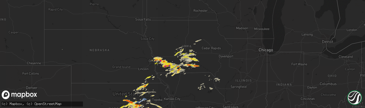
Hail Map on September 17, 2022
The weather event on September 17, 2022 includes Wind and Hail maps. 11 states and 390 cities were impacted and suffered possible damage. The total estimated number of properties impacted is 99,871.
Want more than just the map?
Turn this storm into a full workflow.
- Owner + property data so you know who to knock
- OnDemand branded weather history reports to win the "did we even have hail?" argument
- RoofTrace estimate so reps stop guessing numbers at the door
Bought this map? Upgrade within 7 days and we'll credit the $230. (10-15 min setup call)
Wind
Hail
99,871
Estimated number of impacted properties by a 1.00" hail or larger14,906
Estimated number of impacted properties by a 1.75" hail or larger2,572
Estimated number of impacted properties by a 2.50" hail or largerStates Impacted by Hail Map on September 17, 2022
Storm reports
Nebraska
| Date | Description |
|---|---|
| 09/17/20227:22 AM CDT | At 1221 AM CDT, a severe thunderstorm was located 14 miles southwest of Callaway, or 26 miles southeast of Stapleton, moving east at 30 mph. HAZARD...Golf ball size hail and 60 mph wind gusts. SOURCE...Radar indicated. IMPACT...People and animals outdoors will be injured. Expect hail damage to roofs, siding, windows, and vehicles. Expect wind damage to roofs, siding, and trees. Locations impacted include... Callaway, Oconto, Etna, Lodi and Pressey State Wildlife Management Area. |
| 09/17/20224:00 AM CDT | At 900 PM CDT, a severe thunderstorm was located near Crab Orchard, or 10 miles west of Tecumseh, moving northeast at 35 mph. HAZARD...Quarter size hail. SOURCE...Radar indicated. IMPACT...Damage to vehicles is expected. This severe thunderstorm will be near... Tecumseh around 920 PM CDT. |
| 09/17/20223:15 AM CDT | At 815 PM CDT, severe thunderstorms were located along a line extending from 4 miles west of Neola to Omaha, moving northeast at 35 mph. HAZARD...Half dollar size hail. SOURCE...Radar indicated. IMPACT...Damage to vehicles is expected. Severe thunderstorms will be near... Carter Lake and Minden around 830 PM CDT. Northern Council Bluffs around 835 PM CDT.Other locations in the path of these severe thunderstorms includeShelby, Crescent, Underwood and Neola.This includes the following highways... Interstate 29 between mile markers 54 and 68. Interstate 80 in Iowa between mile markers 11 and 34. |
| 09/16/202210:19 PM CDT | At 318 AM CDT, a severe thunderstorm was centered a few miles north of Naponee, or 23 miles southeast of Holdrege, moving northeast at 25 mph. HAZARD...Quarter size hail. SOURCE...Radar indicated. IMPACT...Damage to vehicles is expected. Locations impacted include... Hildreth, Upland, Naponee and Bloomington. |
| 09/16/20229:20 PM CDT | A local report indicates 1.00 inch wind near TECUMSEH |
| 09/16/20228:16 PM CDT | Report via social media with a picture of 1 hail at 108th and fort. |
| 09/16/20228:00 PM CDT | At 1259 AM CDT, a severe thunderstorm was located 10 miles southwest of Callaway, or 26 miles southwest of Broken Bow, moving east at 30 mph. HAZARD...60 mph wind gusts and half dollar size hail. SOURCE...Radar indicated. IMPACT...Hail damage to vehicles is expected. Expect wind damage to roofs, siding, and trees. Locations impacted include... Oconto, Lodi and Pressey State Wildlife Management Area. |
Missouri
| Date | Description |
|---|---|
| 09/17/20225:10 AM CDT | At 1009 PM CDT, a severe thunderstorm was located near Kellerton, or 11 miles east of Mount Ayr, moving northeast at 45 mph. HAZARD...Quarter size hail. SOURCE...Radar indicated. IMPACT...Damage to vehicles is expected. This severe thunderstorm will be near... Lamoni and Lamoni Municipal Airport around 1015 PM CDT. Davis City and Decatur City around 1025 PM CDT.Other locations in the path of this severe thunderstorm include Leonand Van Wert.This includes Interstate 35 between mile markers 1 and 23. |
| 09/17/20225:00 AM CDT | At 959 PM CDT, a severe thunderstorm was located over Irena, or 14 miles southwest of Mount Ayr, moving northeast at 25 mph. HAZARD...Quarter size hail. SOURCE...Radar indicated. IMPACT...Damage to vehicles is expected. This severe thunderstorm will be near... Redding around 1010 PM CDT. Maloy around 1015 PM CDT.Other locations in the path of this severe thunderstorm includeDelphos, Benton, Mount Ayr and Mt Ayr Municipal Airport. |
| 09/17/20224:53 AM CDT | At 953 PM CDT, a severe thunderstorm was located over Grant City, or 17 miles southwest of Mount Ayr, moving northeast at 25 mph. HAZARD...60 mph wind gusts and quarter size hail. SOURCE...Radar indicated. IMPACT...Hail damage to vehicles is expected. Expect wind damage to roofs, siding, and trees. Locations impacted include... Grant City, Irena and Allendale. |
| 09/17/20222:33 AM CDT | At 733 PM CDT, a severe thunderstorm was located 4 miles south of Johnson, or 8 miles west of Auburn, moving northeast at 50 mph. HAZARD...60 mph wind gusts and quarter size hail. SOURCE...Radar indicated. IMPACT...Hail damage to vehicles is expected. Expect wind damage to roofs, siding, and trees. This severe thunderstorm will be near... Auburn around 745 PM CDT.Other locations in the path of this severe thunderstorm include Peruand Brownville. |
Iowa
| Date | Description |
|---|---|
| 09/17/20226:58 PM CDT | Hail report received by broadcast media from social media report. |
| 09/17/20226:47 PM CDT | A local report indicates 1.75 inch wind near 2 E LUCAS |
| 09/17/20225:53 PM CDT | Penny and nickel sized hail mixed in with some quarter size hail. |
| 09/17/202210:55 AM CDT | Time estimated from radar. |
| 09/17/20226:26 AM CDT | At 1125 PM CDT, a severe thunderstorm was located near Clearfield, or 11 miles west of Mount Ayr, moving northeast at 35 mph. HAZARD...Quarter size hail. SOURCE...Radar indicated. IMPACT...Damage to vehicles is expected. This severe thunderstorm will be near... Delphos around 1130 PM CDT. Benton around 1135 PM CDT. Diagonal around 1140 PM CDT. Mount Ayr and Mt Ayr Municipal Airport around 1145 PM CDT.Other locations in the path of this severe thunderstorm includeShannon City. |
| 09/17/20226:12 AM CDT | At 1112 PM CDT, a severe thunderstorm was located over Grand River, or 12 miles west of Leon, moving northeast at 20 mph. HAZARD...Half dollar size hail. SOURCE...Radar indicated. IMPACT...Damage to vehicles is expected. This severe thunderstorm will be near... Grand River around 1120 PM CDT.Other locations in the path of this severe thunderstorm include VanWert.This includes Interstate 35 between mile markers 17 and 25. |
| 09/17/20225:56 AM CDT | At 1056 PM CDT, a severe thunderstorm was located over Prescott, or 7 miles east of Corning, moving southeast at 30 mph. HAZARD...Ping pong ball size hail and 60 mph wind gusts. SOURCE...Radar indicated. IMPACT...People and animals outdoors will be injured. Expect hail damage to roofs, siding, windows, and vehicles. Expect wind damage to roofs, siding, and trees. This severe thunderstorm will be near... Lenox and Cromwell around 1105 PM CDT. Kent around 1110 PM CDT. Creston Municipal Airport around 1115 PM CDT.Other locations in the path of this severe thunderstorm includeDiagonal, Arispe and Shannon City. |
| 09/17/20225:51 AM CDT | At 1050 PM CDT, a severe thunderstorm was located near Kellerton, or 6 miles northeast of Mount Ayr, moving north at 30 mph. HAZARD...60 mph wind gusts and quarter size hail. SOURCE...Radar indicated. IMPACT...Hail damage to vehicles is expected. Expect wind damage to roofs, siding, and trees. This severe thunderstorm will be near... Ellston and Beaconsfield around 1100 PM CDT. Sun Valley Lake and Grand River around 1105 PM CDT. |
| 09/17/20225:27 AM CDT | At 1027 PM CDT, a severe thunderstorm was located near Arispe, or 12 miles southeast of Creston, moving northeast at 45 mph. HAZARD...Quarter size hail. SOURCE...Radar indicated. IMPACT...Damage to vehicles is expected. This severe thunderstorm will be near... Afton around 1030 PM CDT. Thayer around 1035 PM CDT. Murray Roadside Rest Area around 1040 PM CDT. Murray and Lorimor around 1045 PM CDT. |
| 09/17/20225:19 AM CDT | At 1019 PM CDT, a severe thunderstorm was located near Grant, or 13 miles northwest of Corning, moving east at 30 mph. HAZARD...Quarter size hail. SOURCE...Radar indicated. IMPACT...Damage to vehicles is expected. This severe thunderstorm will be near... Carbon around 1035 PM CDT.Other locations in the path of this severe thunderstorm includeCorning, Corning Municipal Airport, Lake Icaria, Lake Icaria StatePark and Prescott. |
| 09/17/20225:06 AM CDT | At 1005 PM CDT, a severe thunderstorm was located 5 miles north of Lake Icaria, or 10 miles north of Corning, moving east at 20 mph. HAZARD...Ping pong ball size hail and 60 mph wind gusts. SOURCE...Radar indicated. IMPACT...People and animals outdoors will be injured. Expect hail damage to roofs, siding, windows, and vehicles. Expect wind damage to roofs, siding, and trees. This severe thunderstorm will be near... Bridgewater around 1020 PM CDT.Other locations in the path of this severe thunderstorm includeFontanelle and Nodaway Park. |
| 09/17/20225:03 AM CDT | At 1003 PM CDT, a severe thunderstorm was located 4 miles southeast of Elliott, or 9 miles northeast of Red Oak, moving east at 30 mph. HAZARD...Golf ball size hail and 60 mph wind gusts. SOURCE...Radar indicated. IMPACT...People and animals outdoors will be injured. Expect hail damage to roofs, siding, windows, and vehicles. Expect wind damage to roofs, siding, and trees. This severe thunderstorm will be near... Grant around 1015 PM CDT. |
| 09/17/20224:48 AM CDT | At 948 PM CDT, a severe thunderstorm was located 5 miles north of Carbon, or 10 miles northwest of Corning, moving east at 15 mph. HAZARD...Quarter size hail. SOURCE...Radar indicated. IMPACT...Damage to vehicles is expected. This severe thunderstorm will remain over mainly rural areas of northwestern Adams County. |
| 09/17/20224:37 AM CDT | At 937 PM CDT, a severe thunderstorm was located 5 miles southeast of Melbourne, or 11 miles north of Newton, moving east at 40 mph. HAZARD...60 mph wind gusts and quarter size hail. SOURCE...Radar indicated. IMPACT...Hail damage to vehicles is expected. Expect wind damage to roofs, siding, and trees. This severe thunderstorm will be near... Haverhill around 945 PM CDT. Laurel around 950 PM CDT. Ferguson around 955 PM CDT.Other locations in the path of this severe thunderstorm includeGilman. |
| 09/17/20224:31 AM CDT | At 931 PM CDT, a severe thunderstorm was located over Lenox, or 12 miles southeast of Corning, moving northeast at 30 mph. HAZARD...Quarter size hail. SOURCE...Trained weather spotters. At 928pm, nickel to quarter sized hail was reported in Lenox. IMPACT...Damage to vehicles is expected. This severe thunderstorm will be near... Kent around 945 PM CDT. Cromwell around 950 PM CDT. |
| 09/17/20224:28 AM CDT | At 926 PM CDT, a severe thunderstorm was located 5 miles north of Treynor, or 14 miles east of Council Bluffs, moving east at 30 mph. HAZARD...Half dollar size hail. SOURCE...Radar indicated. IMPACT...Damage to vehicles is expected. This severe thunderstorm will be near... Carson around 945 PM CDT.Other locations in the path of this severe thunderstorm include Oakland. This storm is following nearly the same track as another severe storm in Pottawatamie county. |
| 09/17/20224:27 AM CDT | At 927 PM CDT, a severe thunderstorm was located near Cumberland, or 11 miles south of Atlantic, moving east at 20 mph. HAZARD...Quarter size hail. SOURCE...Radar indicated. IMPACT...Damage to vehicles is expected. This severe thunderstorm will be near... Cumberland around 935 PM CDT.Other locations in the path of this severe thunderstorm includeMassena. |
| 09/17/20224:21 AM CDT | At 920 PM CDT, a severe thunderstorm was located over Carson, or 19 miles northwest of Red Oak, moving east at 20 mph. THIS IS A DESTRUCTIVE STORM FOR THE AREA BETWEEN OAKLAND AND CARSON. HAZARD...Baseball size hail and 60 mph wind gusts. SOURCE...Radar indicated. IMPACT...People and animals outdoors will be severely injured. Expect shattered windows, extensive damage to roofs, siding, and vehicles. Locations impacted include... Elliott. |
| 09/17/20224:12 AM CDT | At 911 PM CDT, a severe thunderstorm was located near Beacon, or 5 miles west of Oskaloosa, moving east at 30 mph. HAZARD...60 mph wind gusts and quarter size hail. SOURCE...Radar indicated. IMPACT...Hail damage to vehicles is expected. Expect wind damage to roofs, siding, and trees. This severe thunderstorm will be near... Beacon around 920 PM CDT. Oskaloosa, Eddyville and University Park around 925 PM CDT.Other locations in the path of this severe thunderstorm includeKeomah Village, Lake Keomah State Park, Rose Hill, OskaloosaMunicipal Airport and Fremont. |
| 09/17/20224:07 AM CDT | At 907 PM CDT, a severe thunderstorm was located over Lambs Grove, or near Newton, moving east at 40 mph. HAZARD...60 mph wind gusts and quarter size hail. SOURCE...Radar indicated. IMPACT...Hail damage to vehicles is expected. Expect wind damage to roofs, siding, and trees. This severe thunderstorm will be near... Newton around 910 PM CDT. Iowa Speedway, Reasnor and Newton Municipal Airport around 915 PM CDT. Kellogg around 925 PM CDT.Other locations in the path of this severe thunderstorm include RockCreek Lake, Sully, Oakland Acres, Lynnville, Grinnell RegionalAirport, Grinnell and Searsboro.This includes Interstate 80 between mile markers 151 and 187. |
| 09/17/20224:06 AM CDT | At 905 PM CDT, a severe thunderstorm was located 5 miles south of Grant, or 11 miles east of Red Oak, moving northeast at 35 mph. A second developing severe thunderstorm was located 3 miles northeast of Red Oak, also moving northeast at 35 mph. HAZARD...Half dollar size hail. SOURCE...Radar indicated. IMPACT...Damage to vehicles is expected. This severe thunderstorm will be near... Grant around 915 PM CDT. |
| 09/17/20223:54 AM CDT | At 854 PM CDT, a severe thunderstorm was located just west of Griswold, or 12 miles southwest of Atlantic, moving northeast at 25 mph. HAZARD...Quarter size hail. SOURCE...Radar indicated. IMPACT...Damage to vehicles is expected. This severe thunderstorm will be near... Cold Springs State Park around 905 PM CDT. Lewis around 910 PM CDT.Other locations in the path of this severe thunderstorm includeMarne, Atlantic Municipal Airport, Atlantic and Wiota.This includes Interstate 80 between mile markers 55 and 56. |
| 09/17/20223:45 AM CDT | At 845 PM CDT, a severe thunderstorm was located 4 miles southeast of Underwood, or 15 miles northeast of Council Bluffs, moving east at 30 mph. HAZARD...Golf ball size hail. SOURCE...Radar indicated. IMPACT...People and animals outdoors will be injured. Expect damage to roofs, siding, windows, and vehicles. This severe thunderstorm will be near... Carson around 905 PM CDT.Other locations in the path of this severe thunderstorm includeOakland and Hancock.This includes Interstate 80 in Iowa between mile markers 14 and 20. |
| 09/17/20223:44 AM CDT | At 844 PM CDT, a severe thunderstorm was located near Lenox, or 7 miles southeast of Corning, moving northeast at 30 mph. HAZARD...60 mph wind gusts and quarter size hail. SOURCE...Radar indicated. IMPACT...Hail damage to vehicles is expected. Expect wind damage to roofs, siding, and trees. This severe thunderstorm will be near... Prescott around 850 PM CDT. Kent around 900 PM CDT.Other locations in the path of this severe thunderstorm includeCromwell, Creston Municipal Airport, Creston, Green Valley Lake andGreen Valley Lake State Park. |
| 09/17/20223:42 AM CDT | At 841 PM CDT, a severe thunderstorm was located 5 miles northwest of Elliott, or 12 miles north of Red Oak, moving east at 20 mph. HAZARD...Golf ball size hail. SOURCE...Radar indicated. IMPACT...People and animals outdoors will be injured. Expect damage to roofs, siding, windows, and vehicles. This severe thunderstorm will remain over mainly rural areas of southeastern Pottawattamie County, including the following locations... Farm Creek Public Wildlife Area. |
| 09/17/20223:28 AM CDT | At 828 PM CDT, a severe thunderstorm was located near Elliott, or 12 miles northeast of Red Oak, moving east at 30 mph. HAZARD...60 mph wind gusts and quarter size hail. SOURCE...Radar indicated. IMPACT...Hail damage to vehicles is expected. Expect wind damage to roofs, siding, and trees. Locations impacted include... Cumberland and Massena. |
| 09/17/20223:25 AM CDT | At 825 PM CDT, a severe thunderstorm was located over Lake Red Rock, or near Knoxville, moving east at 40 mph. HAZARD...60 mph wind gusts and quarter size hail. SOURCE...Radar indicated. IMPACT...Hail damage to vehicles is expected. Expect wind damage to roofs, siding, and trees. This severe thunderstorm will be near... Pella and Pella Municipal Airport around 835 PM CDT. Harvey around 840 PM CDT. Bussey around 845 PM CDT.Other locations in the path of this severe thunderstorm includeLeighton, Beacon and Oskaloosa. |
| 09/17/20223:22 AM CDT | At 822 PM CDT, a severe thunderstorm was located over Redfield, or 9 miles west of Adel, moving east at 30 mph. HAZARD...60 mph wind gusts and quarter size hail. SOURCE...Radar indicated. IMPACT...Hail damage to vehicles is expected. Expect wind damage to roofs, siding, and trees. This severe thunderstorm will be near... Dallas Center around 840 PM CDT.Other locations in the path of this severe thunderstorm include Adel,Minburn, Waukee and Urbandale.This includes Interstate 80 near mile marker 120. |
| 09/17/20223:11 AM CDT | At 810 PM CDT, a severe thunderstorm was located over Carbon, or 6 miles west of Corning, moving east at 30 mph. HAZARD...Golf ball size hail and 60 mph wind gusts. SOURCE...Radar indicated. IMPACT...People and animals outdoors will be injured. Expect hail damage to roofs, siding, windows, and vehicles. Expect wind damage to roofs, siding, and trees. This severe thunderstorm will be near... Carbon around 815 PM CDT. Corning and Corning Municipal Airport around 820 PM CDT. Lake Icaria and Lake Icaria State Park around 830 PM CDT.Other locations in the path of this severe thunderstorm includePrescott. |
| 09/17/20223:01 AM CDT | At 800 PM CDT, a severe thunderstorm was located over Johnston, moving east at 40 mph. HAZARD...60 mph wind gusts and quarter size hail. SOURCE...Public. IMPACT...Hail damage to vehicles is expected. Expect wind damage to roofs, siding, and trees. This severe thunderstorm will be near... Saylorville around 805 PM CDT. Des Moines, Ankeny and Margo Frankel Woods State Park around 810 PM CDT. Adventureland Amusement Park, Prairie Meadows, Ankeny Regional Airport and Weh-Weh-Neh-Kee State Park around 815 PM CDT. Altoona, Bondurant and Elkhart around 820 PM CDT.Other locations in the path of this severe thunderstorm includeMitchellville.This includes the following highways... Interstate 35 between mile markers 87 and 98. Interstate 80 between mile markers 128 and 149. Interstate 235 near mile marker 14. |
| 09/17/20222:55 AM CDT | At 754 PM CDT, a severe thunderstorm was located near Albia Municipal Airport, or 6 miles southeast of Albia, moving east at 40 mph. HAZARD...60 mph wind gusts and quarter size hail. SOURCE...Radar indicated. IMPACT...Hail damage to vehicles is expected. Expect wind damage to roofs, siding, and trees. This severe thunderstorm will be near... Blakesburg around 805 PM CDT. |
| 09/17/20222:53 AM CDT | At 753 PM CDT, a severe thunderstorm was located 3 miles west of Henderson, or 16 miles northwest of Red Oak, moving east at 25 mph. HAZARD...Ping pong ball size hail and 60 mph wind gusts. SOURCE...Radar indicated. IMPACT...People and animals outdoors will be injured. Expect hail damage to roofs, siding, windows, and vehicles. Expect wind damage to roofs, siding, and trees. This severe thunderstorm will be near... Henderson around 800 PM CDT. Macedonia around 805 PM CDT.Other locations in the path of this severe thunderstorm includeElliott. |
| 09/17/20222:41 AM CDT | At 741 PM CDT, a severe thunderstorm was located near Swan, or 13 miles northwest of Knoxville, moving east at 30 mph. HAZARD...60 mph wind gusts and quarter size hail. SOURCE...Radar indicated. IMPACT...Hail damage to vehicles is expected. Expect wind damage to roofs, siding, and trees. This severe thunderstorm will be near... Monroe and Lake Red Rock around 755 PM CDT. Elk Rock State Park around 800 PM CDT.Other locations in the path of this severe thunderstorm include PellaMunicipal Airport and Pella. |
| 09/17/20222:36 AM CDT | At 736 PM CDT, a severe thunderstorm was located over Hacklebarney Woods County Park, or 10 miles west of Corning, moving east at 25 mph. HAZARD...60 mph wind gusts and quarter size hail. SOURCE...Radar indicated. IMPACT...Hail damage to vehicles is expected. Expect wind damage to roofs, siding, and trees. This severe thunderstorm will be near... Nodaway around 740 PM CDT. Carbon around 750 PM CDT.Other locations in the path of this severe thunderstorm includeCorning, Corning Municipal Airport, Lake Icaria and Lake Icaria StatePark. |
| 09/17/20222:23 AM CDT | At 722 PM CDT, a severe thunderstorm was located 6 miles south of Red Oak, moving east at 35 mph. HAZARD...Two inch hail and 60 mph wind gusts. SOURCE...Radar indicated. IMPACT...People and animals outdoors will be injured. Expect hail damage to roofs, siding, windows, and vehicles. Expect wind damage to roofs, siding, and trees. This severe thunderstorm will be near... Stanton around 740 PM CDT.Other locations in the path of this severe thunderstorm includeVillisca. |
| 09/17/20222:17 AM CDT | At 716 PM CDT, a severe thunderstorm was located 5 miles northwest of Glenwood, or 5 miles east of Offutt AFB, moving northeast at 30 mph. HAZARD...Half dollar size hail. SOURCE...Radar indicated. IMPACT...Damage to vehicles is expected. This severe thunderstorm will be near... Silver City around 730 PM CDT.Other locations in the path of this severe thunderstorm includeTreynor, Carson and Macedonia.This includes Interstate 29 between mile markers 39 and 42. |
| 09/17/20222:14 AM CDT | At 713 PM CDT, a severe thunderstorm was located 3 miles north of Council Bluffs Airport, or 7 miles northeast of Council Bluffs, moving east at 35 mph. HAZARD...Half dollar size hail. SOURCE...Radar indicated. IMPACT...Damage to vehicles is expected. This severe thunderstorm will be near... Underwood around 725 PM CDT.Other locations in the path of this severe thunderstorm includeMinden, Oakland, Hancock and Avoca.This includes Interstate 80 in Iowa between mile markers 8 and 23,and between mile markers 34 and 40. |
| 09/17/20222:12 AM CDT | At 712 PM CDT, a severe thunderstorm was located near Carlisle, or 7 miles southeast of Des Moines, moving northeast at 35 mph. HAZARD...60 mph wind gusts and quarter size hail. SOURCE...Radar indicated. IMPACT...Hail damage to vehicles is expected. Expect wind damage to roofs, siding, and trees. This severe thunderstorm will be near... Carlisle around 715 PM CDT. Pleasant Hill, Iowa State Fairgrounds and Hartford around 720 PM CDT. Runnells and Swan around 730 PM CDT.This includes the following highways... Interstate 80 near mile marker 144, and between mile markers 146 and147. Interstate 235 between mile markers 10 and 11. |
| 09/17/20222:09 AM CDT | At 709 PM CDT, a severe thunderstorm was located near Russell, or 8 miles east of Chariton, moving east at 45 mph. HAZARD...Ping pong ball size hail and 60 mph wind gusts. SOURCE...Radar indicated. IMPACT...People and animals outdoors will be injured. Expect hail damage to roofs, siding, windows, and vehicles. Expect wind damage to roofs, siding, and trees. This severe thunderstorm will be near... Melrose around 715 PM CDT.Other locations in the path of this severe thunderstorm include Albiaand Albia Municipal Airport. |
| 09/17/20222:07 AM CDT | At 706 PM CDT, a severe thunderstorm was located near Red Oak, moving northeast at 45 mph. HAZARD...60 mph wind gusts and quarter size hail. SOURCE...Radar indicated. IMPACT...Hail damage to vehicles is expected. Expect wind damage to roofs, siding, and trees. Locations impacted include... Cumberland and Massena. |
| 09/17/20222:01 AM CDT | At 701 PM CDT, a severe thunderstorm was located over Elliott, or 9 miles northeast of Red Oak, moving northeast at 30 mph. A second severe thunderstorm was located 3 miles west of Red Oak, also moving northeast at 30 mph. HAZARD...Half dollar size hail. SOURCE...Radar indicated. IMPACT...Damage to vehicles is expected. This severe thunderstorm will be near... Grant around 715 PM CDT. |
| 09/17/20221:47 AM CDT | At 647 PM CDT, a severe thunderstorm was located near Martensdale, or 6 miles southwest of Norwalk, moving east at 45 mph. HAZARD...60 mph wind gusts and quarter size hail. SOURCE...Radar indicated. IMPACT...Hail damage to vehicles is expected. Expect wind damage to roofs, siding, and trees. This severe thunderstorm will be near... Spring Hill around 655 PM CDT. Indianola, Norwalk and Des Moines Int'l Airport around 700 PM CDT. Southridge Mall and Principal Park around 705 PM CDT.Other locations in the path of this severe thunderstorm includePleasant Hill, Carlisle, Iowa State Fairgrounds and Hartford.This includes the following highways... Interstate 35 between mile markers 56 and 67. Interstate 235 between mile markers 9 and 12. |
| 09/17/20221:27 AM CDT | At 627 PM CDT, a severe thunderstorm was located over Lucas, or 6 miles west of Chariton, moving east at 35 mph. HAZARD...60 mph wind gusts and quarter size hail. SOURCE...Radar indicated. IMPACT...Hail damage to vehicles is expected. Expect wind damage to roofs, siding, and trees. This severe thunderstorm will be near... Chariton and Chariton Municipal Airport around 635 PM CDT. Red Haw Lake State Park around 640 PM CDT. Williamson around 645 PM CDT.Other locations in the path of this severe thunderstorm includeRussell and Melrose. |
| 09/16/202210:55 PM CDT | Corrects previous hail report from corning. Time estimated from radar. |
| 09/16/202210:45 PM CDT | Lake acaria. |
| 09/16/202210:22 PM CDT | Quarter to larger-size hail reported. |
| 09/16/20229:51 PM CDT | From spotternetwork. |
| 09/16/20229:31 PM CDT | From spotternetwork. |
| 09/16/20229:22 PM CDT | Report called in from the public. |
| 09/16/20229:19 PM CDT | Report with pictures received via social media. |
| 09/16/20229:10 PM CDT | Estimated 70 mph or stronger wind gust with pea size hail. Time estimated based on radar. |
| 09/16/20229:00 PM CDT | Mixed with dime sized hail. |
| 09/16/20228:58 PM CDT | A local report indicates 1.75 inch wind near GRISWOLD |
| 09/16/20228:50 PM CDT | A local report indicates 1.00 inch wind near 1 WSW MINBURN |
| 09/16/20228:36 PM CDT | A local report indicates 1.00 inch wind near 2 S LAKE RED ROCK |
| 09/16/20228:18 PM CDT | A local report indicates 1.00 inch wind near 3 SSW ALBIA |
| 09/16/20228:12 PM CDT | A local report indicates 1.00 inch wind near 2 ENE URBANDALE |
| 09/16/20228:05 PM CDT | A local report indicates 1.00 inch wind near JOHNSTON |
| 09/16/20227:58 PM CDT | A local report indicates 1.00 inch wind near GRIMES |
| 09/16/20227:45 PM CDT | A local report indicates 2.50 inch wind near STANTON |
| 09/16/20227:43 PM CDT | A local report indicates 1.75 inch wind near 3 S STANTON |
| 09/16/20227:39 PM CDT | Mixed with quarter size hail. |
| 09/16/20227:30 PM CDT | Picture of hail sourced from social media. |
| 09/16/20227:30 PM CDT | Corrects previous hail report from red oak. Should be 3 miles southeast of red oak. Picture of hail sourced from social media. |
| 09/16/20227:17 PM CDT | Time estimated by radar. |
| 09/16/20227:15 PM CDT | Pea to quarter sized hail. |
| 09/16/20227:10 PM CDT | Pictures from social media of hail the size of golf balls just northeast of council bluffs... Time estimated from radar. |
Minnesota
| Date | Description |
|---|---|
| 09/17/20226:40 PM CDT | Public reports half dollar sized hail... And damage to boat gauges caused by the hail. Radar estimated time. |
| 09/17/20226:10 PM CDT | Report of 1-1.25 inch hail within lake bemidji state park. Along with small branches broken. Time estimated based on radar. |
| 09/17/20224:57 AM CDT | At 957 PM CDT, a severe thunderstorm was located near Breezy Point, or 15 miles north of Brainerd, moving east at 20 mph. HAZARD...60 mph wind gusts and quarter size hail. SOURCE...Radar indicated. IMPACT...Hail damage to vehicles is expected. Expect wind damage to roofs, siding, and trees. This severe thunderstorm will be near... Crosby around 1020 PM CDT. Cuyuna around 1025 PM CDT. Aitkin around 1045 PM CDT.Other locations impacted by this severe thunderstorm include EdwardLake, Wolford, Cedar Lake, Pine Knoll, Mission, Upper Mission Lake,Esquagamah Lake, Trommald and Lower Mission Lake. |
| 09/17/20224:14 AM CDT | At 913 PM CDT, a severe thunderstorm was located 8 miles east of Leader, or 19 miles northwest of Brainerd, moving east at 20 mph. HAZARD...60 mph wind gusts and quarter size hail. SOURCE...Radar indicated. IMPACT...Hail damage to vehicles is expected. Expect wind damage to roofs, siding, and trees. This severe thunderstorm will be near... Gull Lake around 930 PM CDT. Pequot Lakes and Nisswa around 945 PM CDT. Breezy Point around 1000 PM CDT.Other locations impacted by this severe thunderstorm include LakeShore, Jenkins, Lower Whitefish Lake, Edward Lake, Lower Hay Lake,Big Trout Lake, Lake Hubert and Lower Mission Lake. |
| 09/17/20223:42 AM CDT | At 842 PM CDT, a severe thunderstorm was located near Nisswa, or 13 miles north of Brainerd, moving east at 30 mph. HAZARD...60 mph wind gusts and quarter size hail. SOURCE...Radar indicated. IMPACT...Hail damage to vehicles is expected. Expect wind damage to roofs, siding, and trees. This severe thunderstorm will be near... Breezy Point around 850 PM CDT. Ironton around 905 PM CDT. Crosby around 910 PM CDT. Cuyuna around 915 PM CDT. Aitkin around 930 PM CDT.Other locations impacted by this severe thunderstorm include EdwardLake, Wolford, Cedar Lake, Pine Knoll, Ripple Lake, Cuyuna CountryState Park, Mission, Upper Mission Lake, Esquagamah Lake and LakeHubert. |
| 09/17/20223:03 AM CDT | At 802 PM CDT, a severe thunderstorm was located near Leader, or 19 miles northwest of Brainerd, moving east at 20 mph. HAZARD...60 mph wind gusts and quarter size hail. SOURCE...Radar indicated. IMPACT...Hail damage to vehicles is expected. Expect wind damage to roofs, siding, and trees. Locations impacted include... Gull Lake, Nisswa and Merrifield. |
| 09/17/20221:54 AM CDT | At 654 PM CDT, a severe thunderstorm was located 10 miles northwest of Lake Winnibigoshish, or 23 miles east of Bemidji, moving east at 20 mph. HAZARD...Ping pong ball size hail and 60 mph wind gusts. SOURCE...Radar indicated. IMPACT...People and animals outdoors will be injured. Expect hail damage to roofs, siding, windows, and vehicles. Expect wind damage to roofs, siding, and trees. This severe thunderstorm will be near... Lake Winnibigoshish around 730 PM CDT. Inger around 745 PM CDT.Other locations impacted by this severe thunderstorm include SandLake, Max, Dixon Lake, Bowstring Lake, Cut Foot Sioux Lake and BallClub Lake. |
| 09/17/20221:28 AM CDT | At 627 PM CDT, a severe thunderstorm was located near Pennington, or 18 miles east of Bemidji, moving east at 35 mph. HAZARD...60 mph wind gusts and quarter size hail. SOURCE...Radar indicated. IMPACT...Hail damage to vehicles is expected. Expect wind damage to roofs, siding, and trees. This severe thunderstorm will remain over mainly rural areas of southeastern Beltrami County. |
| 09/17/20221:16 AM CDT | At 616 PM CDT, a severe thunderstorm was located near Turtle River, or 9 miles northeast of Bemidji, moving east at 30 mph. HAZARD...Ping pong ball size hail and 60 mph wind gusts. SOURCE...Radar indicated. IMPACT...People and animals outdoors will be injured. Expect hail damage to roofs, siding, windows, and vehicles. Expect wind damage to roofs, siding, and trees. This severe thunderstorm will be near... Squaw Lake and Alvwood around 700 PM CDT.Other locations impacted by this severe thunderstorm include DeckerLake, Rosy, Max and Dixon Lake. |
| 09/17/202212:48 AM CDT | At 548 PM CDT, a severe thunderstorm was located near Solway, or 9 miles west of Bemidji, moving east at 30 mph. HAZARD...60 mph wind gusts and quarter size hail. SOURCE...Radar indicated. IMPACT...Hail damage to vehicles is expected. Expect wind damage to roofs, siding, and trees. This severe thunderstorm will be near... Wilton around 555 PM CDT. Bemidji and Plantagenet Lake around 600 PM CDT.Other locations in the path of this severe thunderstorm includeLavinia, Lake Bemidji State Park, Turtle River and Pennington. |
| 09/17/202212:42 AM CDT | At 542 PM CDT, a severe thunderstorm was located near Lake George, or 23 miles south of Bemidji, moving northeast at 25 mph. HAZARD...60 mph wind gusts and quarter size hail. SOURCE...Radar indicated. IMPACT...Hail damage to vehicles is expected. Expect wind damage to roofs, siding, and trees. This severe thunderstorm will be near... Kabekona around 550 PM CDT. Laporte around 600 PM CDT.Other locations in the path of this severe thunderstorm includeBenedict and Guthrie. |
| 09/17/202212:10 AM CDT | Medium sized tree downed across a county road. |
| 09/16/20228:20 PM CDT | Shared via social media. |
Kansas
| Date | Description |
|---|---|
| 09/17/20226:59 PM CDT | A local report indicates 1.00 inch wind near 4 W MARYSVILLE |
| 09/17/20226:30 PM CDT | A local report indicates 1.50 inch wind near LINCOLN |
| 09/17/20224:40 PM CDT | Trees stripped of their leaves. |
| 09/17/20224:40 PM CDT | A local report indicates 1.00 inch wind near 3 N NEOSHO RAPIDS |
| 09/17/20224:30 PM CDT | Estimated wind speed. Tree limbs and power lines are down and blocking roads. |
| 09/17/20224:21 PM CDT | A local report indicates 1.75 inch wind near 4 NW NEOSHO RAPIDS |
| 09/17/20224:07 PM CDT | A local report indicates 1.00 inch wind near 4 NNE EMPORIA |
| 09/17/20224:05 PM CDT | Kemp. |
| 09/17/20224:03 PM CDT | Asos station kemp emporia. |
| 09/17/20224:02 PM CDT | Lot of tree limbs and power lines down. One house had tree fall onto roof. Estimated wind gusts of 65 mph. |
| 09/17/20223:52 PM CDT | Lots of tree limb damage and a few small trees |
| 09/17/20223:30 PM CDT | Delayed report. Reported numerous large hail stones with quarter being the largest observed. Wind was up to 40 mph. |
| 09/17/20223:21 PM CDT | A local report indicates 2.00 inch wind near AMERICUS |
| 09/17/20223:16 PM CDT | Hailed for the past 15 minutes and hail covers the deck. |
| 09/17/20223:10 PM CDT | Spotter had winds of 40 to 60 mph which flattened the bushes and hedges as it was moving across. Pea to dime sized hail occurred as well. Time is estimated from radar. |
| 09/17/20223:00 PM CDT | Delayed report: barn damage... Trees down... Dog house destroyed. |
| 09/17/20221:05 PM CDT | A local report indicates 1.00 inch wind near 3 NNW WILSEY |
| 09/17/20226:55 AM CDT | At 1154 PM CDT, severe thunderstorms were located along a line extending from 3 miles southeast of Talmage to Ramona, moving east at 20 mph. HAZARD...60 mph wind gusts and half dollar size hail. SOURCE...Radar indicated. IMPACT...Hail damage to vehicles is expected. Expect wind damage to roofs, siding, and trees. Locations impacted include... Junction City, Abilene, Herington, Grandview Plaza, Chapman, Enterprise, White City, Hope, Woodbine, Wilsey, Latimer, Talmage, Moonlight and Burdick.This includes Interstate 70 between mile markers 271 and 299.This warning replaces the two warnings currently in effect for Dickinson County. |
| 09/17/20226:37 AM CDT | At 1137 PM CDT, a severe thunderstorm was located 5 miles north of Carlton, moving east at 20 mph. HAZARD...60 mph wind gusts and quarter size hail. SOURCE...Radar indicated. IMPACT...Hail damage to vehicles is expected. Expect wind damage to roofs, siding, and trees. Locations impacted include... Abilene and Enterprise. |
| 09/17/20226:11 AM CDT | At 1111 PM CDT, a severe thunderstorm was located 5 miles south of Carlton, moving east at 20 mph. HAZARD...60 mph wind gusts and half dollar size hail. SOURCE...Radar indicated. IMPACT...Hail damage to vehicles is expected. Expect wind damage to roofs, siding, and trees. Locations impacted include... Hope and Carlton. |
| 09/17/20225:04 AM CDT | At 1004 PM CDT, a severe thunderstorm was located 6 miles southeast of Ogden, moving east at 30 mph. HAZARD...70 mph wind gusts and penny size hail. SOURCE...Trained weather spotters. IMPACT...Expect considerable tree damage. Damage is likely to mobile homes, roofs, and outbuildings. Locations impacted include... Southern Manhattan and Ogden. This includes Interstate 70 between mile markers 306 and 316. |
| 09/17/20224:54 AM CDT | At 954 PM CDT, a severe thunderstorm was located near Marysville, moving east at 30 mph. HAZARD...60 mph wind gusts and quarter size hail. SOURCE...Radar indicated. IMPACT...Hail damage to vehicles is expected. Expect wind damage to roofs, siding, and trees. Locations impacted include... Marysville, Beattie and Summerfield. |
| 09/17/20224:50 AM CDT | At 949 PM CDT, a severe thunderstorm was located 4 miles east of Ogden, moving northeast at 50 mph. HAZARD...70 mph wind gusts. SOURCE...Trained weather spotters. This storm has produced some strong wind gusts in and around Junction City. IMPACT...Expect considerable tree damage. Damage is likely to mobile homes, roofs, and outbuildings. Locations impacted include... Northeastern Manhattan, Wamego, St. Marys, St. George, Belvue and Louisville.This includes Interstate 70 between mile markers 317 and 323. |
| 09/17/20224:35 AM CDT | At 934 PM CDT, a severe thunderstorm was located near Junction City, moving northeast at 45 mph. HAZARD...70 mph wind gusts. SOURCE...Radar indicated. IMPACT...Expect considerable tree damage. Damage is likely to mobile homes, roofs, and outbuildings. Locations impacted include... Manhattan, Junction City, Ogden and Grandview Plaza. This includes Interstate 70 between mile markers 297 and 318. |
| 09/17/20224:32 AM CDT | At 932 PM CDT, a severe thunderstorm was located over Marquette, or 10 miles west of Lindsborg, moving east at 10 mph. HAZARD...Ping pong ball size hail and 60 mph wind gusts. SOURCE...Radar indicated. IMPACT...People and animals outdoors will be injured. Expect hail damage to roofs, siding, windows, and vehicles. Expect wind damage to roofs, siding, and trees. Locations impacted include... Lindsborg, Marquette, Assaria, Gypsum, Falun, Bridgeport and Roxbury.This includes Interstate 135 between Mile Markers 65 and 86. |
| 09/17/20224:13 AM CDT | At 912 PM CDT, severe thunderstorms were located along a line extending from near Abilene to 6 miles northeast of Carlton, moving east at 30 mph. HAZARD...70 mph wind gusts and quarter size hail. SOURCE...Radar indicated. These storms have a history of producing wind gusts between 60 and 80 MPH. IMPACT...Hail damage to vehicles is expected. Expect considerable tree damage. Wind damage is also likely to mobile homes, roofs, and outbuildings. Locations impacted include... Junction City, Abilene, Herington, Chapman, Enterprise, Hope, Woodbine, Latimer and Moonlight.This includes Interstate 70 between mile markers 274 and 297. |
| 09/17/20223:45 AM CDT | At 845 PM CDT, a severe thunderstorm was located over Arlington, or 12 miles northwest of Pretty Prairie, moving east at 20 mph. HAZARD...Golf ball size hail and 70 mph wind gusts. SOURCE...Radar indicated. IMPACT...People and animals outdoors will be injured. Expect hail damage to roofs, siding, windows, and vehicles. Expect considerable tree damage. Wind damage is also likely to mobile homes, roofs, and outbuildings. Locations impacted include... Hutchinson, South Hutchinson, Haven, Pretty Prairie, Arlington, Partridge, Abbyville, Yoder, Cheney Lake and Cheney State Park. |
| 09/17/20223:29 AM CDT | At 828 PM CDT, a severe thunderstorm was located over New Cambria, moving east at 20 mph. HAZARD...Golf ball size hail and 60 mph wind gusts. SOURCE...Trained weather spotters. This storm has produced golf ball sized hail in near New Cambria. IMPACT...People and animals outdoors will be injured. Expect hail damage to roofs, siding, windows, and vehicles. Expect wind damage to roofs, siding, and trees. Locations impacted include... Abilene, Solomon and Carlton. This includes Interstate 70 between mile markers 267 and 277. |
| 09/17/20223:25 AM CDT | At 825 PM CDT, a severe thunderstorm was located near Brookville, or 9 miles west of Salina, moving northeast at 45 mph. HAZARD...60 mph wind gusts and half dollar size hail. SOURCE...Radar indicated. IMPACT...Hail damage to vehicles is expected. Expect wind damage to roofs, siding, and trees. Locations impacted include... Salina, Assaria, Gypsum, Brookville, Smolan, New Cambria, Falun, Bridgeport, Salina Airport and Kipp.This includes the following highways... Interstate 135 between Mile Markers 77 and 95. Interstate 70 between Mile Markers 251 and 253. |
| 09/17/20223:02 AM CDT | At 802 PM CDT, a severe thunderstorm was located near Little River, or 6 miles northeast of Lyons, moving northeast at 35 mph. HAZARD...60 mph wind gusts and quarter size hail. SOURCE...Public. IMPACT...Hail damage to vehicles is expected. Expect wind damage to roofs, siding, and trees. Locations impacted include... Mcpherson, Lindsborg, Marquette, Little River, Windom and Mcpherson Airport.This includes Interstate 135 between Mile Markers 56 and 76. |
| 09/17/20222:47 AM CDT | At 747 PM CDT, a severe thunderstorm was located near Sylvia, or near Zenith, moving east at 35 mph. HAZARD...60 mph wind gusts and half dollar size hail. SOURCE...Radar indicated. IMPACT...Hail damage to vehicles is expected. Expect wind damage to roofs, siding, and trees. Locations impacted include... Hutchinson, South Hutchinson, Inman, Buhler, Haven, Nickerson, Arlington, Partridge, Sylvia, Plevna, Abbyville, Yoder, Willowbrook and Hutchinson Airport. |
| 09/17/20222:43 AM CDT | At 742 PM CDT, a severe thunderstorm was located near Linn, moving northeast at 20 mph. HAZARD...60 mph wind gusts and quarter size hail. SOURCE...Radar indicated. This storms has a history of producing 60 mph winds. IMPACT...Hail damage to vehicles is expected. Expect wind damage to roofs, siding, and trees. Locations impacted include... Greenleaf and Barnes. |
| 09/17/20222:42 AM CDT | At 742 PM CDT, a severe thunderstorm was located over Lorraine, or 10 miles northeast of Claflin, moving northeast at 35 mph. HAZARD...Ping pong ball size hail and 60 mph wind gusts. SOURCE...Radar indicated. IMPACT...People and animals outdoors will be injured. Expect hail damage to roofs, siding, windows, and vehicles. Expect wind damage to roofs, siding, and trees. Locations impacted include... Ellsworth, Kanopolis, Holyrood, Bushton, Geneseo, Lorraine, Frederick, Kanopolis Lake, Kanopolis State Park and Ellsworth Airport.This includes Interstate 70 between Mile Markers 225 and 228. |
| 09/17/20222:38 AM CDT | At 737 PM CDT, a severe thunderstorm was located near Culver, moving east at 15 mph. HAZARD...Golf ball size hail and 70 mph wind gusts. SOURCE...Trained weather spotters. This storm has a history of producing large hail in Tescott. IMPACT...People and animals outdoors will be injured. Expect hail damage to roofs, siding, windows, and vehicles. Expect considerable tree damage. Wind damage is also likely to mobile homes, roofs, and outbuildings. Locations impacted include... Bennington, Tescott, Culver and Niles. |
| 09/17/20222:33 AM CDT | At 733 PM CDT, a severe thunderstorm was located near Tescott, or 15 miles southeast of Lincoln, moving east at 20 mph. HAZARD...60 mph wind gusts and half dollar size hail. SOURCE...Radar indicated. IMPACT...Hail damage to vehicles is expected. Expect wind damage to roofs, siding, and trees. Locations impacted include... Salina, Beverly, New Cambria and Glendale. This includes the following highways... Interstate 135 between Mile Markers 93 and 95. Interstate 70 between Mile Markers 235 and 266. |
| 09/17/20222:28 AM CDT | At 728 PM CDT, a severe thunderstorm was located near Marysville, moving northeast at 30 mph. HAZARD...60 mph wind gusts and quarter size hail. SOURCE...Radar indicated. IMPACT...Hail damage to vehicles is expected. Expect wind damage to roofs, siding, and trees. Locations impacted include... Marysville, Axtell and Beattie. |
| 09/17/20222:27 AM CDT | At 727 PM CDT, a severe thunderstorm was located near Stafford, moving east at 25 mph. HAZARD...Quarter size hail. SOURCE...Radar indicated. IMPACT...Damage to vehicles is expected. This severe thunderstorm will be near... Zenith around 745 PM CDT. |
| 09/17/20222:26 AM CDT | Measured 2.21 inches of rainfall. |
| 09/17/20222:20 AM CDT | At 720 PM CDT, a severe thunderstorm was located over Palmer, moving east at 35 mph. HAZARD...60 mph wind gusts and quarter size hail. SOURCE...Radar indicated. IMPACT...Hail damage to vehicles is expected. Expect wind damage to roofs, siding, and trees. Locations impacted include... Linn, Greenleaf, Barnes and Palmer. |
| 09/17/20222:03 AM CDT | At 703 PM CDT, a severe thunderstorm was located near Great Bend, moving northeast at 25 mph. HAZARD...Ping pong ball size hail and 60 mph wind gusts. SOURCE...Radar indicated. IMPACT...People and animals outdoors will be injured. Expect hail damage to roofs, siding, windows, and vehicles. Expect wind damage to roofs, siding, and trees. Locations impacted include... Great Bend, Ellinwood, Claflin, Chase, Holyrood, Bushton, Cheyenne Bottoms, Silica and Odin. |
| 09/17/20221:56 AM CDT | At 656 PM CDT, a severe thunderstorm was located near Marysville, moving east at 25 mph. HAZARD...60 mph wind gusts and quarter size hail. SOURCE...Radar indicated. IMPACT...Hail damage to vehicles is expected. Expect wind damage to roofs, siding, and trees. Locations impacted include... Marysville and Oketo. |
| 09/17/20221:54 AM CDT | At 654 PM CDT, a severe thunderstorm was located over Beverly, moving east at 15 mph. HAZARD...Ping pong ball size hail and 60 mph wind gusts. SOURCE...Radar indicated. IMPACT...People and animals outdoors will be injured. Expect hail damage to roofs, siding, windows, and vehicles. Expect wind damage to roofs, siding, and trees. Locations impacted include... Minneapolis, Tescott and Culver. |
| 09/17/20221:40 AM CDT | At 639 PM CDT, a severe thunderstorm was located 7 miles southwest of Glasco, or 15 miles northwest of Minneapolis, moving northeast at 30 mph. HAZARD...Half dollar size hail. SOURCE...Radar indicated. IMPACT...Damage to vehicles is expected. Locations impacted include... Rural areas of far southeast Mitchell county. |
| 09/17/20221:32 AM CDT | At 632 PM CDT, a severe thunderstorm was located 4 miles north of Barnes, moving east at 25 mph. HAZARD...60 mph wind gusts and quarter size hail. SOURCE...Radar indicated. IMPACT...Hail damage to vehicles is expected. Expect wind damage to roofs, siding, and trees. Locations impacted include... Marysville, Blue Rapids, Waterville, Barnes and Bremen. |
| 09/17/20221:30 AM CDT | At 630 PM CDT, a severe thunderstorm was located over Lincoln, moving east at 25 mph. Golf ball sized hail has been reported with this storm. HAZARD...Two inch hail and 70 mph wind gusts. SOURCE...Law enforcement. IMPACT...People and animals outdoors will be injured. Expect hail damage to roofs, siding, windows, and vehicles. Expect considerable tree damage. Wind damage is also likely to mobile homes, roofs, and outbuildings. Locations impacted include... Lincoln, Beverly, Barnard and Westfall. |
| 09/17/20221:24 AM CDT | At 624 PM CDT, a severe thunderstorm was located over Lincoln, moving northeast at 20 mph. HAZARD...Golf ball size hail and 70 mph wind gusts. SOURCE...Radar indicated. IMPACT...People and animals outdoors will be injured. Expect hail damage to roofs, siding, windows, and vehicles. Expect considerable tree damage. Wind damage is also likely to mobile homes, roofs, and outbuildings. Locations impacted include... Lincoln, Beverly, Barnard and Westfall. |
| 09/16/202211:38 PM CDT | At 438 PM CDT, a severe thunderstorm was located near Neosho Rapids, moving southeast at 15 mph. HAZARD...Two inch hail and 60 mph wind gusts. SOURCE...Radar indicated. IMPACT...People and animals outdoors will be injured. Expect hail damage to roofs, siding, windows, and vehicles. Expect wind damage to roofs, siding, and trees. Locations impacted include... Lebo, Hartford, Neosho Rapids, Reading and Beto Junction. This includes Interstate 35 between mile markers 137 and 158. |
| 09/16/202211:18 PM CDT | At 417 PM CDT, a severe thunderstorm was located 7 miles southwest of Reading, moving east at 15 mph. HAZARD...Two inch hail and 60 mph wind gusts. SOURCE...Radar indicated. IMPACT...People and animals outdoors will be injured. Expect hail damage to roofs, siding, windows, and vehicles. Expect wind damage to roofs, siding, and trees. Locations impacted include... Lebo, Hartford, Neosho Rapids and Reading. This includes the following highways... Interstate 35 between mile markers 138 and 149. Kansas Turnpike between mile markers 142 and 144. |
| 09/16/202211:13 PM CDT | At 412 PM CDT, a severe thunderstorm was located 4 miles northeast of Emporia, moving east at 10 mph. HAZARD...60 mph wind gusts and quarter size hail. SOURCE...Radar indicated. At 4:05pm, a 59mph wind gusts was measured at the Emporia Airport. IMPACT...Hail damage to vehicles is expected. Expect wind damage to roofs, siding, and trees. This severe thunderstorm will remain over mainly rural areas of southeastern Lyon County. |
| 09/16/202211:05 PM CDT | At 404 AM CDT, a severe thunderstorm was located near Republic, moving northeast at 20 mph. HAZARD...60 mph wind gusts and half dollar size hail. SOURCE...Radar indicated. IMPACT...Hail damage to vehicles is expected. Expect wind damage to roofs, siding, and trees. Locations impacted include... Republic. |
| 09/16/202210:56 PM CDT | At 355 PM CDT, a severe thunderstorm was located 4 miles southeast of Americus, moving east at 10 mph. HAZARD...Two inch hail and 70 mph wind gusts. SOURCE...Radar indicated. IMPACT...People and animals outdoors will be injured. Expect hail damage to roofs, siding, windows, and vehicles. Expect considerable tree damage. Wind damage is also likely to mobile homes, roofs, and outbuildings. Locations impacted include... Emporia and Americus. This includes the following highways... Interstate 35 between mile markers 128 and 138. Kansas Turnpike between mile markers 123 and 142. |
| 09/16/202210:43 PM CDT | At 343 PM CDT, a severe thunderstorm was located near Emporia, moving east at 30 mph. HAZARD...60 mph wind gusts and quarter size hail. SOURCE...Radar indicated. IMPACT...Hail damage to vehicles is expected. Expect wind damage to roofs, siding, and trees. Locations impacted include... Emporia.This includes Kansas Turnpike between mile markers 118 and 124. |
| 09/16/202210:25 PM CDT | At 324 PM CDT, a severe thunderstorm was located 4 miles south of Americus, moving northeast at 25 mph. HAZARD...70 mph wind gusts and ping pong ball size hail. SOURCE...Radar indicated. IMPACT...People and animals outdoors will be injured. Expect hail damage to roofs, siding, windows, and vehicles. Expect considerable tree damage. Wind damage is also likely to mobile homes, roofs, and outbuildings. Locations impacted include... Emporia and Americus. This includes the following highways... Interstate 35 between mile markers 128 and 138. Kansas Turnpike between mile markers 124 and 141. |
| 09/16/202210:03 PM CDT | A local report indicates 1.50 inch wind near 2 E MARYSVILLE |
| 09/16/20229:56 PM CDT | At 255 PM CDT, a severe thunderstorm was located near Americus, moving east at 35 mph. HAZARD...60 mph wind gusts and half dollar size hail. SOURCE...Radar indicated. IMPACT...Hail damage to vehicles is expected. Expect wind damage to roofs, siding, and trees. Locations impacted include... Americus, Allen, Admire and Dunlap. This includes Kansas Turnpike between mile markers 129 and 143. |
| 09/16/20229:55 PM CDT | Asos station kmhk manhattan. |
| 09/16/20229:55 PM CDT | Ksu mesonet. |
| 09/16/20229:40 PM CDT | A local report indicates 70 MPH wind near 2 S GRANDVIEW PLAZA |
| 09/16/20229:39 PM CDT | Sign blown down on us highway 77. |
| 09/16/20229:36 PM CDT | Received through social media. |
| 09/16/20229:36 PM CDT | Corrects previous hail report from marquette. Received through social media. |
| 09/16/20229:35 PM CDT | At 235 PM CDT, a severe thunderstorm was located 6 miles north of Strong City, moving northeast at 20 mph. HAZARD...60 mph wind gusts and quarter size hail. SOURCE...Radar indicated. IMPACT...Hail damage to vehicles is expected. Expect wind damage to roofs, siding, and trees. Locations impacted include... Strong City, Tallgrass Prairie and Tallgrass Prairie Preserve. |
| 09/16/20229:32 PM CDT | At 231 PM CDT, a severe thunderstorm was located near Dunlap, moving northeast at 30 mph. HAZARD...60 mph wind gusts and quarter size hail. SOURCE...Radar indicated. IMPACT...Hail damage to vehicles is expected. Expect wind damage to roofs, siding, and trees. Locations impacted include... Americus, Allen, Bushong and Dunlap. This includes Kansas Turnpike between mile markers 140 and 141. |
| 09/16/20229:25 PM CDT | Delayed report: 4 to 6 inch diameter tree limb snapped. |
| 09/16/20229:25 PM CDT | Three inch tree branch torn off healthy maple tree. |
| 09/16/20229:20 PM CDT | High confidence in 70 mph gusts. No confirmed damage at this time. |
| 09/16/20229:09 PM CDT | A local report indicates 65 MPH wind near 4 SSW ABILENE |
| 09/16/20229:04 PM CDT | Spotter confirmed severe wind gusts. |
| 09/16/20228:55 PM CDT | Hwy 61 covered with hail. |
| 09/16/20228:40 PM CDT | A local report indicates 1.00 inch wind near 2 SSE SALINA |
| 09/16/20228:39 PM CDT | A local report indicates 78 MPH wind near 3 SW SALINA |
| 09/16/20228:39 PM CDT | A local report indicates 78 MPH wind near SALINA MUNICIPAL AIRPOR |
| 09/16/20228:36 PM CDT | Received through social media. |
| 09/16/20228:33 PM CDT | Delayed report from social media. |
| 09/16/20228:25 PM CDT | Estimated 60 mph winds also. |
| 09/16/20228:17 PM CDT | A local report indicates 1.75 inch wind near 1 W NEW CAMBRIA |
| 09/16/20228:13 PM CDT | A local report indicates 1.75 inch wind near 7 WNW NEW CAMBRIA |
| 09/16/20228:07 PM CDT | A local report indicates 1.00 inch wind near KANOPOLIS |
| 09/16/20228:00 PM CDT | At 1259 PM CDT, a severe thunderstorm was located near Wilsey, moving northeast at 30 mph. HAZARD...60 mph wind gusts and quarter size hail. SOURCE...Radar indicated. IMPACT...Hail damage to vehicles is expected. Expect wind damage to roofs, siding, and trees. Locations impacted include... Council Grove, Dwight, Wilsey, Parkerville and Council Grove Lake. |
| 09/16/20227:53 PM CDT | A local report indicates 1.00 inch wind near LYONS |
| 09/16/20227:45 PM CDT | Also 60mph winds. |
| 09/16/20227:32 PM CDT | A local report indicates 60 MPH wind near 2 WNW LINN |
| 09/16/20227:32 PM CDT | A local report indicates 1.25 inch wind near TESCOTT |
| 09/16/20227:27 PM CDT | Hail covering ground. |
| 09/16/20227:23 PM CDT | No damage at the time of observation. |
| 09/16/20227:16 PM CDT | Ground completely covered with dimes and quarters. |
| 09/16/20227:15 PM CDT | Maintenance staff reported a broken pole on a wooden fence and two broke off wooden poles of a highway sign along ks highway 156. There are a couple large cottonwood tr |
| 09/16/20227:14 PM CDT | Trained spotter reported 8 to 10 inch tree branch down in town. Time is estimated from neighboring reports. |
| 09/16/20227:13 PM CDT | Half dollar sized hail also reported. |
| 09/16/20227:09 PM CDT | Delayed report. |
| 09/16/20227:04 PM CDT | A local report indicates 1.00 inch wind near BEVERLY |
Oklahoma
| Date | Description |
|---|---|
| 09/17/20226:30 PM CDT | A local report indicates 1.00 inch wind near 5 E HARMON |
| 09/17/20225:28 PM CDT | A local report indicates 1.00 inch wind near 6 S SHATTUCK |
| 09/17/20221:55 AM CDT | At 655 PM CDT, a severe thunderstorm was located near Vici, moving east at 20 mph. HAZARD...60 mph wind gusts and quarter size hail. SOURCE...Radar indicated. IMPACT...Hail damage to vehicles is expected. Expect wind damage to roofs, siding, and trees. Locations impacted include... Vici, Mutual and Cestos. |
| 09/17/20221:00 AM CDT | At 559 PM CDT, a severe thunderstorm was located 5 miles west of Harmon, moving east at 20 mph. HAZARD...60 to 70 mph wind gusts and quarter size hail. SOURCE...Radar indicated. IMPACT...Hail damage to vehicles is expected. Expect considerable tree damage. Wind damage is also likely to mobile homes, roofs, and outbuildings. Locations impacted include... Vici, Sharon and Harmon. |
| 09/16/202211:47 PM CDT | At 447 PM CDT, a severe thunderstorm was located 4 miles northwest of Higgins, moving east at 20 mph. HAZARD...60 to 70 mph wind gusts and half dollar size hail. SOURCE...Radar indicated. IMPACT...Hail damage to vehicles is expected. Expect considerable tree damage. Wind damage is also likely to mobile homes, roofs, and outbuildings. Locations impacted include... Shattuck, Arnett, Gage and Fargo. |
| 09/16/202211:12 PM CDT | At 412 PM CDT, a severe thunderstorm was located 5 miles southwest of Lipscomb, moving northeast at 25 mph. HAZARD...60 mph wind gusts and quarter size hail. SOURCE...Radar indicated. IMPACT...Minor damage to roofs, siding, and trees is possible. Hail damage to vehicles is expected. Locations impacted include... Lipscomb, Follett and Higgins. |
Cities Impacted by Hail Map on September 17, 2022
- Perry, IA
- Liscomb, IA
- Conrad, IA
- Beaman, IA
- Panora, IA
- Kelley, IA
- Minburn, IA
- Dallas Center, IA
- Waukee, IA
- Madrid, IA
- Stuart, IA
- Adel, IA
- Bouton, IA
- Redfield, IA
- Polk City, IA
- Granger, IA
- Menlo, IA
- Linden, IA
- Woodward, IA
- Earlham, IA
- Ogden, IA
- Boone, IA
- Jamaica, IA
- Rippey, IA
- New Virginia, IA
- Bruce Crossing, MI
- State Center, IA
- Davis City, IA
- Leon, IA
- Ankeny, IA
- Des Moines, IA
- Deer River, MN
- Memphis, MO
- Bondurant, IA
- Altoona, IA
- Hudson, IA
- Dike, IA
- Morrison, IA
- Cedar Falls, IA
- Waterloo, IA
- Grundy Center, IA
- Reinbeck, IA
- Prairie City, IA
- Otley, IA
- Saint Charles, IA
- Sully, IA
- Winterset, IA
- Urbandale, IA
- Patterson, IA
- Melcher Dallas, IA
- Swan, IA
- Windsor Heights, IA
- Tracy, IA
- Pleasantville, IA
- Milo, IA
- Pleasant Hill, IA
- Martensdale, IA
- Colfax, IA
- Clive, IA
- Van Meter, IA
- Knoxville, IA
- Grimes, IA
- Hartford, IA
- Killduff, IA
- Runnells, IA
- Truro, IA
- Lacona, IA
- Norwalk, IA
- Pella, IA
- Harvey, IA
- Mitchellville, IA
- Oskaloosa, IA
- West Des Moines, IA
- Peru, IA
- Leighton, IA
- Ackworth, IA
- Carlisle, IA
- Prole, IA
- Reasnor, IA
- Indianola, IA
- Johnston, IA
- Beacon, IA
- Monroe, IA
- Lynnville, IA
- Newton, IA
- Cumming, IA
- Blue Springs, NE
- Beatrice, NE
- Lake Linden, MI
- Maryville, MO
- Skidmore, MO
- Auburn, NE
- Johnson, NE
- Plano, IA
- Crab Orchard, NE
- Tecumseh, NE
- Virginia, NE
- Lewiston, NE
- Bayfield, WI
- Alta Vista, KS
- Alma, KS
- Liberty, NE
- Kellogg, IA
- Lucas, IA
- Watersmeet, MI
- Burlington Junction, MO
- Clearmont, MO
- Gravity, IA
- Bedford, IA
- Crosslake, MN
- Motley, MN
- Nisswa, MN
- Merrifield, MN
- Staples, MN
- Pequot Lakes, MN
- Crosby, MN
- Ames, IA
- Tarkio, MO
- Palisade, MN
- Grand River, IA
- Murray, IA
- Ellston, IA
- Orient, IA
- Greenfield, IA
- Loraine, IL
- Mendon, IL
- Ursa, IL
- New Market, IA
- Nodaway, IA
- Minneapolis, KS
- Abilene, KS
- Longford, KS
- Higgins, TX
- Golden, IL
- West Point, IL
- Bowen, IL
- Warsaw, IL
- Sutter, IL
- Basco, IL
- Anabel, MO
- Macon, MO
- Cass Lake, MN
- Pennington, MN
- Blackduck, MN
- Bemidji, MN
- Palmer, KS
- Clifton, KS
- Clay Center, KS
- Barnes, KS
- Lyons, KS
- Manhattan, KS
- Onaga, KS
- Green, KS
- Randolph, KS
- Riley, KS
- Westmoreland, KS
- Leonardville, KS
- Olsburg, KS
- Morganville, KS
- Havensville, KS
- Sheridan, MO
- Grant City, MO
- Underwood, IA
- Council Bluffs, IA
- McClelland, IA
- Kellerton, IA
- Hatfield, MO
- Lamoni, IA
- Mount Ayr, IA
- Decatur, IA
- Monroe City, MO
- Palmyra, MO
- Stafford, KS
- Sylvia, KS
- Arlington, KS
- St John, KS
- Haven, KS
- Hutchinson, KS
- Pretty Prairie, KS
- Abbyville, KS
- Plevna, KS
- Partridge, KS
- Clarinda, IA
- Collins, IA
- Rhodes, IA
- Baxter, IA
- Melbourne, IA
- Hannibal, MO
- Greenleaf, KS
- Shannon City, IA
- Thayer, IA
- Afton, IA
- Brookville, KS
- Oakland, IA
- Russell, IA
- Moravia, IA
- Osceola, IA
- Chariton, IA
- Blakesburg, IA
- Derby, IA
- Albia, IA
- Melrose, IA
- Woodburn, IA
- Marquette, KS
- Saint Marys, KS
- Gypsum, KS
- Villisca, IA
- Red Oak, IA
- Stanton, IA
- Creston, IA
- Quenemo, KS
- Pomona, KS
- Vassar, KS
- Lyndon, KS
- Americus, KS
- Council Grove, KS
- Clearfield, IA
- Blockton, IA
- Van Wert, IA
- Benton, IA
- Diagonal, IA
- Tingley, IA
- Redding, IA
- Neosho Rapids, KS
- Emporia, KS
- Reading, KS
- Lebo, KS
- Wilsey, KS
- Hancock, IA
- Avoca, IA
- Minden, IA
- Bremen, KS
- Marysville, KS
- Delia, KS
- Emmett, KS
- Berwick, IA
- Scranton, KS
- Burlingame, KS
- Eskridge, KS
- Harveyville, KS
- Overbrook, KS
- Ottawa, KS
- Washington, KS
- Home, KS
- Waterville, KS
- Beattie, KS
- Frankfort, KS
- Linn, KS
- Hanover, KS
- Ira, IA
- Mingo, IA
- Wymore, NE
- Barneston, NE
- Atlanta, MO
- Worth, MO
- White City, KS
- Tampa, KS
- Herington, KS
- Lindsborg, KS
- Geneseo, KS
- Ramona, KS
- Solomon, KS
- Salina, KS
- New Cambria, KS
- Lincoln, KS
- Assaria, KS
- Tescott, KS
- Durham, KS
- Beverly, KS
- Hope, KS
- Ellsworth, KS
- Lenox, IA
- Princeton, KS
- Griswold, IA
- Lewis, IA
- Elliott, IA
- Crescent, IA
- Honey Creek, IA
- Lorraine, KS
- Holyrood, KS
- Bushton, KS
- Glenwood, IA
- Clarence, MO
- Shelbyville, MO
- Lewistown, MO
- Novelty, MO
- Brandon, MN
- Garfield, MN
- Chapman, KS
- Junction City, KS
- Sharon, OK
- Arnett, OK
- Windom, KS
- Little River, KS
- Leonard, MO
- Lentner, MO
- Pacific Junction, IA
- Holton, KS
- Soldier, KS
- Circleville, KS
- Falun, KS
- Oketo, KS
- Strong City, KS
- Admire, KS
- Corning, IA
- Blue Rapids, KS
- Carson, IA
- Great Bend, KS
- Claflin, KS
- Ellinwood, KS
- Belpre, KS
- Prescott, IA
- Carbon, IA
- Macedonia, IA
- Bridgewater, IA
- Cumberland, IA
- Massena, IA
- Neola, IA
- Emerson, IA
- Grant, IA
- Missouri Valley, IA
- Sharpsburg, IA
- Treynor, IA
- Henderson, IA
- Malvern, IA
- Callao, MO
- Bevier, MO
- Vermillion, KS
- Cottonwood Falls, KS
- Fontana, KS
- La Cygne, KS
- Amsterdam, MO
- Paola, KS
- Williamsburg, KS
- Richmond, KS
- Greeley, KS
- Grinnell, IA
- Williamstown, MO
- Kahoka, MO
- Wyaconda, MO
- Mercer, MO
- Cainsville, MO
- Humboldt, NE
- Camp Point, IL
- Burdick, KS
- Clyde, KS
- Garden Grove, IA
- Hopkins, MO
- Fort Calhoun, NE
- Omaha, NE
- Shelby, IA
- Parnell, MO
- Silver City, IA
- Atlantic, IA
- Solway, MN
- Shevlin, MN
- Excello, MO
- Kanopolis, KS
- Goff, KS
- Parker, KS
- Lane, KS
- Osage City, KS
- Concordia, KS
- Beloit, KS
- Brock, NE
- Louisburg, KS
- Belvue, KS
- Hudson, KS
- Vici, OK
- Glasco, KS
- Barnard, KS
- Ottumwa, IA
- Weldon, IA
- Lovilia, IA
- Chase, KS
- Cotton, MN
- Rosholt, SD
- Raymond, KS
- Macksville, KS
- Carter Lake, IA
- Trimble, MO
- Enterprise, KS
- Ogden, KS
- Fort Riley, KS
- Mineola, IA
- Filley, NE
- Bennington, KS
- Summerfield, KS
- Park Rapids, MN
- Hines, MN