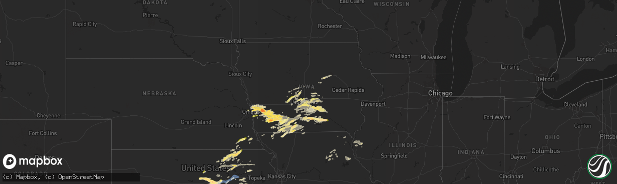
Hail Map in Iowa on September 17, 2022
The weather event in Iowa on September 17, 2022 includes Wind and Hail maps. 11 states and 390 cities were impacted and suffered possible damage. The total estimated number of properties impacted is 58,885.
Want more than just the map?
Turn this storm into a full workflow.
- Owner + property data so you know who to knock
- OnDemand branded weather history reports to win the "did we even have hail?" argument
- RoofTrace estimate so reps stop guessing numbers at the door
Bought this map? Upgrade within 7 days and we'll credit the $230. (10-15 min setup call)
Wind
Hail
58,885
Estimated number of impacted properties by a 1.00" hail or larger7,969
Estimated number of impacted properties by a 1.75" hail or larger1,789
Estimated number of impacted properties by a 2.50" hail or largerStorm reports in Iowa
Iowa
| Date | Description |
|---|---|
| 09/17/20226:58 PM CDT | Hail report received by broadcast media from social media report. |
| 09/17/20226:47 PM CDT | A local report indicates 1.75 inch wind near 2 E LUCAS |
| 09/17/20225:53 PM CDT | Penny and nickel sized hail mixed in with some quarter size hail. |
| 09/17/202210:55 AM CDT | Time estimated from radar. |
| 09/17/20226:26 AM CDT | At 1125 PM CDT, a severe thunderstorm was located near Clearfield, or 11 miles west of Mount Ayr, moving northeast at 35 mph. HAZARD...Quarter size hail. SOURCE...Radar indicated. IMPACT...Damage to vehicles is expected. This severe thunderstorm will be near... Delphos around 1130 PM CDT. Benton around 1135 PM CDT. Diagonal around 1140 PM CDT. Mount Ayr and Mt Ayr Municipal Airport around 1145 PM CDT.Other locations in the path of this severe thunderstorm includeShannon City. |
| 09/17/20226:12 AM CDT | At 1112 PM CDT, a severe thunderstorm was located over Grand River, or 12 miles west of Leon, moving northeast at 20 mph. HAZARD...Half dollar size hail. SOURCE...Radar indicated. IMPACT...Damage to vehicles is expected. This severe thunderstorm will be near... Grand River around 1120 PM CDT.Other locations in the path of this severe thunderstorm include VanWert.This includes Interstate 35 between mile markers 17 and 25. |
| 09/17/20225:56 AM CDT | At 1056 PM CDT, a severe thunderstorm was located over Prescott, or 7 miles east of Corning, moving southeast at 30 mph. HAZARD...Ping pong ball size hail and 60 mph wind gusts. SOURCE...Radar indicated. IMPACT...People and animals outdoors will be injured. Expect hail damage to roofs, siding, windows, and vehicles. Expect wind damage to roofs, siding, and trees. This severe thunderstorm will be near... Lenox and Cromwell around 1105 PM CDT. Kent around 1110 PM CDT. Creston Municipal Airport around 1115 PM CDT.Other locations in the path of this severe thunderstorm includeDiagonal, Arispe and Shannon City. |
| 09/17/20225:51 AM CDT | At 1050 PM CDT, a severe thunderstorm was located near Kellerton, or 6 miles northeast of Mount Ayr, moving north at 30 mph. HAZARD...60 mph wind gusts and quarter size hail. SOURCE...Radar indicated. IMPACT...Hail damage to vehicles is expected. Expect wind damage to roofs, siding, and trees. This severe thunderstorm will be near... Ellston and Beaconsfield around 1100 PM CDT. Sun Valley Lake and Grand River around 1105 PM CDT. |
| 09/17/20225:27 AM CDT | At 1027 PM CDT, a severe thunderstorm was located near Arispe, or 12 miles southeast of Creston, moving northeast at 45 mph. HAZARD...Quarter size hail. SOURCE...Radar indicated. IMPACT...Damage to vehicles is expected. This severe thunderstorm will be near... Afton around 1030 PM CDT. Thayer around 1035 PM CDT. Murray Roadside Rest Area around 1040 PM CDT. Murray and Lorimor around 1045 PM CDT. |
| 09/17/20225:19 AM CDT | At 1019 PM CDT, a severe thunderstorm was located near Grant, or 13 miles northwest of Corning, moving east at 30 mph. HAZARD...Quarter size hail. SOURCE...Radar indicated. IMPACT...Damage to vehicles is expected. This severe thunderstorm will be near... Carbon around 1035 PM CDT.Other locations in the path of this severe thunderstorm includeCorning, Corning Municipal Airport, Lake Icaria, Lake Icaria StatePark and Prescott. |
| 09/17/20225:06 AM CDT | At 1005 PM CDT, a severe thunderstorm was located 5 miles north of Lake Icaria, or 10 miles north of Corning, moving east at 20 mph. HAZARD...Ping pong ball size hail and 60 mph wind gusts. SOURCE...Radar indicated. IMPACT...People and animals outdoors will be injured. Expect hail damage to roofs, siding, windows, and vehicles. Expect wind damage to roofs, siding, and trees. This severe thunderstorm will be near... Bridgewater around 1020 PM CDT.Other locations in the path of this severe thunderstorm includeFontanelle and Nodaway Park. |
| 09/17/20225:03 AM CDT | At 1003 PM CDT, a severe thunderstorm was located 4 miles southeast of Elliott, or 9 miles northeast of Red Oak, moving east at 30 mph. HAZARD...Golf ball size hail and 60 mph wind gusts. SOURCE...Radar indicated. IMPACT...People and animals outdoors will be injured. Expect hail damage to roofs, siding, windows, and vehicles. Expect wind damage to roofs, siding, and trees. This severe thunderstorm will be near... Grant around 1015 PM CDT. |
| 09/17/20224:48 AM CDT | At 948 PM CDT, a severe thunderstorm was located 5 miles north of Carbon, or 10 miles northwest of Corning, moving east at 15 mph. HAZARD...Quarter size hail. SOURCE...Radar indicated. IMPACT...Damage to vehicles is expected. This severe thunderstorm will remain over mainly rural areas of northwestern Adams County. |
| 09/17/20224:37 AM CDT | At 937 PM CDT, a severe thunderstorm was located 5 miles southeast of Melbourne, or 11 miles north of Newton, moving east at 40 mph. HAZARD...60 mph wind gusts and quarter size hail. SOURCE...Radar indicated. IMPACT...Hail damage to vehicles is expected. Expect wind damage to roofs, siding, and trees. This severe thunderstorm will be near... Haverhill around 945 PM CDT. Laurel around 950 PM CDT. Ferguson around 955 PM CDT.Other locations in the path of this severe thunderstorm includeGilman. |
| 09/17/20224:31 AM CDT | At 931 PM CDT, a severe thunderstorm was located over Lenox, or 12 miles southeast of Corning, moving northeast at 30 mph. HAZARD...Quarter size hail. SOURCE...Trained weather spotters. At 928pm, nickel to quarter sized hail was reported in Lenox. IMPACT...Damage to vehicles is expected. This severe thunderstorm will be near... Kent around 945 PM CDT. Cromwell around 950 PM CDT. |
| 09/17/20224:28 AM CDT | At 926 PM CDT, a severe thunderstorm was located 5 miles north of Treynor, or 14 miles east of Council Bluffs, moving east at 30 mph. HAZARD...Half dollar size hail. SOURCE...Radar indicated. IMPACT...Damage to vehicles is expected. This severe thunderstorm will be near... Carson around 945 PM CDT.Other locations in the path of this severe thunderstorm include Oakland. This storm is following nearly the same track as another severe storm in Pottawatamie county. |
| 09/17/20224:27 AM CDT | At 927 PM CDT, a severe thunderstorm was located near Cumberland, or 11 miles south of Atlantic, moving east at 20 mph. HAZARD...Quarter size hail. SOURCE...Radar indicated. IMPACT...Damage to vehicles is expected. This severe thunderstorm will be near... Cumberland around 935 PM CDT.Other locations in the path of this severe thunderstorm includeMassena. |
| 09/17/20224:21 AM CDT | At 920 PM CDT, a severe thunderstorm was located over Carson, or 19 miles northwest of Red Oak, moving east at 20 mph. THIS IS A DESTRUCTIVE STORM FOR THE AREA BETWEEN OAKLAND AND CARSON. HAZARD...Baseball size hail and 60 mph wind gusts. SOURCE...Radar indicated. IMPACT...People and animals outdoors will be severely injured. Expect shattered windows, extensive damage to roofs, siding, and vehicles. Locations impacted include... Elliott. |
| 09/17/20224:12 AM CDT | At 911 PM CDT, a severe thunderstorm was located near Beacon, or 5 miles west of Oskaloosa, moving east at 30 mph. HAZARD...60 mph wind gusts and quarter size hail. SOURCE...Radar indicated. IMPACT...Hail damage to vehicles is expected. Expect wind damage to roofs, siding, and trees. This severe thunderstorm will be near... Beacon around 920 PM CDT. Oskaloosa, Eddyville and University Park around 925 PM CDT.Other locations in the path of this severe thunderstorm includeKeomah Village, Lake Keomah State Park, Rose Hill, OskaloosaMunicipal Airport and Fremont. |
| 09/17/20224:07 AM CDT | At 907 PM CDT, a severe thunderstorm was located over Lambs Grove, or near Newton, moving east at 40 mph. HAZARD...60 mph wind gusts and quarter size hail. SOURCE...Radar indicated. IMPACT...Hail damage to vehicles is expected. Expect wind damage to roofs, siding, and trees. This severe thunderstorm will be near... Newton around 910 PM CDT. Iowa Speedway, Reasnor and Newton Municipal Airport around 915 PM CDT. Kellogg around 925 PM CDT.Other locations in the path of this severe thunderstorm include RockCreek Lake, Sully, Oakland Acres, Lynnville, Grinnell RegionalAirport, Grinnell and Searsboro.This includes Interstate 80 between mile markers 151 and 187. |
| 09/17/20224:06 AM CDT | At 905 PM CDT, a severe thunderstorm was located 5 miles south of Grant, or 11 miles east of Red Oak, moving northeast at 35 mph. A second developing severe thunderstorm was located 3 miles northeast of Red Oak, also moving northeast at 35 mph. HAZARD...Half dollar size hail. SOURCE...Radar indicated. IMPACT...Damage to vehicles is expected. This severe thunderstorm will be near... Grant around 915 PM CDT. |
| 09/17/20223:54 AM CDT | At 854 PM CDT, a severe thunderstorm was located just west of Griswold, or 12 miles southwest of Atlantic, moving northeast at 25 mph. HAZARD...Quarter size hail. SOURCE...Radar indicated. IMPACT...Damage to vehicles is expected. This severe thunderstorm will be near... Cold Springs State Park around 905 PM CDT. Lewis around 910 PM CDT.Other locations in the path of this severe thunderstorm includeMarne, Atlantic Municipal Airport, Atlantic and Wiota.This includes Interstate 80 between mile markers 55 and 56. |
| 09/17/20223:45 AM CDT | At 845 PM CDT, a severe thunderstorm was located 4 miles southeast of Underwood, or 15 miles northeast of Council Bluffs, moving east at 30 mph. HAZARD...Golf ball size hail. SOURCE...Radar indicated. IMPACT...People and animals outdoors will be injured. Expect damage to roofs, siding, windows, and vehicles. This severe thunderstorm will be near... Carson around 905 PM CDT.Other locations in the path of this severe thunderstorm includeOakland and Hancock.This includes Interstate 80 in Iowa between mile markers 14 and 20. |
| 09/17/20223:44 AM CDT | At 844 PM CDT, a severe thunderstorm was located near Lenox, or 7 miles southeast of Corning, moving northeast at 30 mph. HAZARD...60 mph wind gusts and quarter size hail. SOURCE...Radar indicated. IMPACT...Hail damage to vehicles is expected. Expect wind damage to roofs, siding, and trees. This severe thunderstorm will be near... Prescott around 850 PM CDT. Kent around 900 PM CDT.Other locations in the path of this severe thunderstorm includeCromwell, Creston Municipal Airport, Creston, Green Valley Lake andGreen Valley Lake State Park. |
| 09/17/20223:42 AM CDT | At 841 PM CDT, a severe thunderstorm was located 5 miles northwest of Elliott, or 12 miles north of Red Oak, moving east at 20 mph. HAZARD...Golf ball size hail. SOURCE...Radar indicated. IMPACT...People and animals outdoors will be injured. Expect damage to roofs, siding, windows, and vehicles. This severe thunderstorm will remain over mainly rural areas of southeastern Pottawattamie County, including the following locations... Farm Creek Public Wildlife Area. |
| 09/17/20223:28 AM CDT | At 828 PM CDT, a severe thunderstorm was located near Elliott, or 12 miles northeast of Red Oak, moving east at 30 mph. HAZARD...60 mph wind gusts and quarter size hail. SOURCE...Radar indicated. IMPACT...Hail damage to vehicles is expected. Expect wind damage to roofs, siding, and trees. Locations impacted include... Cumberland and Massena. |
| 09/17/20223:25 AM CDT | At 825 PM CDT, a severe thunderstorm was located over Lake Red Rock, or near Knoxville, moving east at 40 mph. HAZARD...60 mph wind gusts and quarter size hail. SOURCE...Radar indicated. IMPACT...Hail damage to vehicles is expected. Expect wind damage to roofs, siding, and trees. This severe thunderstorm will be near... Pella and Pella Municipal Airport around 835 PM CDT. Harvey around 840 PM CDT. Bussey around 845 PM CDT.Other locations in the path of this severe thunderstorm includeLeighton, Beacon and Oskaloosa. |
| 09/17/20223:22 AM CDT | At 822 PM CDT, a severe thunderstorm was located over Redfield, or 9 miles west of Adel, moving east at 30 mph. HAZARD...60 mph wind gusts and quarter size hail. SOURCE...Radar indicated. IMPACT...Hail damage to vehicles is expected. Expect wind damage to roofs, siding, and trees. This severe thunderstorm will be near... Dallas Center around 840 PM CDT.Other locations in the path of this severe thunderstorm include Adel,Minburn, Waukee and Urbandale.This includes Interstate 80 near mile marker 120. |
| 09/17/20223:11 AM CDT | At 810 PM CDT, a severe thunderstorm was located over Carbon, or 6 miles west of Corning, moving east at 30 mph. HAZARD...Golf ball size hail and 60 mph wind gusts. SOURCE...Radar indicated. IMPACT...People and animals outdoors will be injured. Expect hail damage to roofs, siding, windows, and vehicles. Expect wind damage to roofs, siding, and trees. This severe thunderstorm will be near... Carbon around 815 PM CDT. Corning and Corning Municipal Airport around 820 PM CDT. Lake Icaria and Lake Icaria State Park around 830 PM CDT.Other locations in the path of this severe thunderstorm includePrescott. |
| 09/17/20223:01 AM CDT | At 800 PM CDT, a severe thunderstorm was located over Johnston, moving east at 40 mph. HAZARD...60 mph wind gusts and quarter size hail. SOURCE...Public. IMPACT...Hail damage to vehicles is expected. Expect wind damage to roofs, siding, and trees. This severe thunderstorm will be near... Saylorville around 805 PM CDT. Des Moines, Ankeny and Margo Frankel Woods State Park around 810 PM CDT. Adventureland Amusement Park, Prairie Meadows, Ankeny Regional Airport and Weh-Weh-Neh-Kee State Park around 815 PM CDT. Altoona, Bondurant and Elkhart around 820 PM CDT.Other locations in the path of this severe thunderstorm includeMitchellville.This includes the following highways... Interstate 35 between mile markers 87 and 98. Interstate 80 between mile markers 128 and 149. Interstate 235 near mile marker 14. |
| 09/17/20222:55 AM CDT | At 754 PM CDT, a severe thunderstorm was located near Albia Municipal Airport, or 6 miles southeast of Albia, moving east at 40 mph. HAZARD...60 mph wind gusts and quarter size hail. SOURCE...Radar indicated. IMPACT...Hail damage to vehicles is expected. Expect wind damage to roofs, siding, and trees. This severe thunderstorm will be near... Blakesburg around 805 PM CDT. |
| 09/17/20222:53 AM CDT | At 753 PM CDT, a severe thunderstorm was located 3 miles west of Henderson, or 16 miles northwest of Red Oak, moving east at 25 mph. HAZARD...Ping pong ball size hail and 60 mph wind gusts. SOURCE...Radar indicated. IMPACT...People and animals outdoors will be injured. Expect hail damage to roofs, siding, windows, and vehicles. Expect wind damage to roofs, siding, and trees. This severe thunderstorm will be near... Henderson around 800 PM CDT. Macedonia around 805 PM CDT.Other locations in the path of this severe thunderstorm includeElliott. |
| 09/17/20222:41 AM CDT | At 741 PM CDT, a severe thunderstorm was located near Swan, or 13 miles northwest of Knoxville, moving east at 30 mph. HAZARD...60 mph wind gusts and quarter size hail. SOURCE...Radar indicated. IMPACT...Hail damage to vehicles is expected. Expect wind damage to roofs, siding, and trees. This severe thunderstorm will be near... Monroe and Lake Red Rock around 755 PM CDT. Elk Rock State Park around 800 PM CDT.Other locations in the path of this severe thunderstorm include PellaMunicipal Airport and Pella. |
| 09/17/20222:36 AM CDT | At 736 PM CDT, a severe thunderstorm was located over Hacklebarney Woods County Park, or 10 miles west of Corning, moving east at 25 mph. HAZARD...60 mph wind gusts and quarter size hail. SOURCE...Radar indicated. IMPACT...Hail damage to vehicles is expected. Expect wind damage to roofs, siding, and trees. This severe thunderstorm will be near... Nodaway around 740 PM CDT. Carbon around 750 PM CDT.Other locations in the path of this severe thunderstorm includeCorning, Corning Municipal Airport, Lake Icaria and Lake Icaria StatePark. |
| 09/17/20222:23 AM CDT | At 722 PM CDT, a severe thunderstorm was located 6 miles south of Red Oak, moving east at 35 mph. HAZARD...Two inch hail and 60 mph wind gusts. SOURCE...Radar indicated. IMPACT...People and animals outdoors will be injured. Expect hail damage to roofs, siding, windows, and vehicles. Expect wind damage to roofs, siding, and trees. This severe thunderstorm will be near... Stanton around 740 PM CDT.Other locations in the path of this severe thunderstorm includeVillisca. |
| 09/17/20222:17 AM CDT | At 716 PM CDT, a severe thunderstorm was located 5 miles northwest of Glenwood, or 5 miles east of Offutt AFB, moving northeast at 30 mph. HAZARD...Half dollar size hail. SOURCE...Radar indicated. IMPACT...Damage to vehicles is expected. This severe thunderstorm will be near... Silver City around 730 PM CDT.Other locations in the path of this severe thunderstorm includeTreynor, Carson and Macedonia.This includes Interstate 29 between mile markers 39 and 42. |
| 09/17/20222:14 AM CDT | At 713 PM CDT, a severe thunderstorm was located 3 miles north of Council Bluffs Airport, or 7 miles northeast of Council Bluffs, moving east at 35 mph. HAZARD...Half dollar size hail. SOURCE...Radar indicated. IMPACT...Damage to vehicles is expected. This severe thunderstorm will be near... Underwood around 725 PM CDT.Other locations in the path of this severe thunderstorm includeMinden, Oakland, Hancock and Avoca.This includes Interstate 80 in Iowa between mile markers 8 and 23,and between mile markers 34 and 40. |
| 09/17/20222:12 AM CDT | At 712 PM CDT, a severe thunderstorm was located near Carlisle, or 7 miles southeast of Des Moines, moving northeast at 35 mph. HAZARD...60 mph wind gusts and quarter size hail. SOURCE...Radar indicated. IMPACT...Hail damage to vehicles is expected. Expect wind damage to roofs, siding, and trees. This severe thunderstorm will be near... Carlisle around 715 PM CDT. Pleasant Hill, Iowa State Fairgrounds and Hartford around 720 PM CDT. Runnells and Swan around 730 PM CDT.This includes the following highways... Interstate 80 near mile marker 144, and between mile markers 146 and147. Interstate 235 between mile markers 10 and 11. |
| 09/17/20222:09 AM CDT | At 709 PM CDT, a severe thunderstorm was located near Russell, or 8 miles east of Chariton, moving east at 45 mph. HAZARD...Ping pong ball size hail and 60 mph wind gusts. SOURCE...Radar indicated. IMPACT...People and animals outdoors will be injured. Expect hail damage to roofs, siding, windows, and vehicles. Expect wind damage to roofs, siding, and trees. This severe thunderstorm will be near... Melrose around 715 PM CDT.Other locations in the path of this severe thunderstorm include Albiaand Albia Municipal Airport. |
| 09/17/20222:07 AM CDT | At 706 PM CDT, a severe thunderstorm was located near Red Oak, moving northeast at 45 mph. HAZARD...60 mph wind gusts and quarter size hail. SOURCE...Radar indicated. IMPACT...Hail damage to vehicles is expected. Expect wind damage to roofs, siding, and trees. Locations impacted include... Cumberland and Massena. |
| 09/17/20222:01 AM CDT | At 701 PM CDT, a severe thunderstorm was located over Elliott, or 9 miles northeast of Red Oak, moving northeast at 30 mph. A second severe thunderstorm was located 3 miles west of Red Oak, also moving northeast at 30 mph. HAZARD...Half dollar size hail. SOURCE...Radar indicated. IMPACT...Damage to vehicles is expected. This severe thunderstorm will be near... Grant around 715 PM CDT. |
| 09/17/20221:47 AM CDT | At 647 PM CDT, a severe thunderstorm was located near Martensdale, or 6 miles southwest of Norwalk, moving east at 45 mph. HAZARD...60 mph wind gusts and quarter size hail. SOURCE...Radar indicated. IMPACT...Hail damage to vehicles is expected. Expect wind damage to roofs, siding, and trees. This severe thunderstorm will be near... Spring Hill around 655 PM CDT. Indianola, Norwalk and Des Moines Int'l Airport around 700 PM CDT. Southridge Mall and Principal Park around 705 PM CDT.Other locations in the path of this severe thunderstorm includePleasant Hill, Carlisle, Iowa State Fairgrounds and Hartford.This includes the following highways... Interstate 35 between mile markers 56 and 67. Interstate 235 between mile markers 9 and 12. |
| 09/17/20221:27 AM CDT | At 627 PM CDT, a severe thunderstorm was located over Lucas, or 6 miles west of Chariton, moving east at 35 mph. HAZARD...60 mph wind gusts and quarter size hail. SOURCE...Radar indicated. IMPACT...Hail damage to vehicles is expected. Expect wind damage to roofs, siding, and trees. This severe thunderstorm will be near... Chariton and Chariton Municipal Airport around 635 PM CDT. Red Haw Lake State Park around 640 PM CDT. Williamson around 645 PM CDT.Other locations in the path of this severe thunderstorm includeRussell and Melrose. |
| 09/16/202210:55 PM CDT | Corrects previous hail report from corning. Time estimated from radar. |
| 09/16/202210:45 PM CDT | Lake acaria. |
| 09/16/202210:22 PM CDT | Quarter to larger-size hail reported. |
| 09/16/20229:51 PM CDT | From spotternetwork. |
| 09/16/20229:31 PM CDT | From spotternetwork. |
| 09/16/20229:22 PM CDT | Report called in from the public. |
| 09/16/20229:19 PM CDT | Report with pictures received via social media. |
| 09/16/20229:10 PM CDT | Estimated 70 mph or stronger wind gust with pea size hail. Time estimated based on radar. |
| 09/16/20229:00 PM CDT | Mixed with dime sized hail. |
| 09/16/20228:58 PM CDT | A local report indicates 1.75 inch wind near GRISWOLD |
| 09/16/20228:50 PM CDT | A local report indicates 1.00 inch wind near 1 WSW MINBURN |
| 09/16/20228:36 PM CDT | A local report indicates 1.00 inch wind near 2 S LAKE RED ROCK |
| 09/16/20228:18 PM CDT | A local report indicates 1.00 inch wind near 3 SSW ALBIA |
| 09/16/20228:12 PM CDT | A local report indicates 1.00 inch wind near 2 ENE URBANDALE |
| 09/16/20228:05 PM CDT | A local report indicates 1.00 inch wind near JOHNSTON |
| 09/16/20227:58 PM CDT | A local report indicates 1.00 inch wind near GRIMES |
| 09/16/20227:45 PM CDT | A local report indicates 2.50 inch wind near STANTON |
| 09/16/20227:43 PM CDT | A local report indicates 1.75 inch wind near 3 S STANTON |
| 09/16/20227:39 PM CDT | Mixed with quarter size hail. |
| 09/16/20227:30 PM CDT | Corrects previous hail report from red oak. Should be 3 miles southeast of red oak. Picture of hail sourced from social media. |
| 09/16/20227:30 PM CDT | Picture of hail sourced from social media. |
| 09/16/20227:17 PM CDT | Time estimated by radar. |
| 09/16/20227:15 PM CDT | Pea to quarter sized hail. |
| 09/16/20227:10 PM CDT | Pictures from social media of hail the size of golf balls just northeast of council bluffs... Time estimated from radar. |
All States Impacted by Hail Map on September 17, 2022
Cities Impacted by Hail Map on September 17, 2022
- Perry, IA
- Liscomb, IA
- Conrad, IA
- Beaman, IA
- Panora, IA
- Kelley, IA
- Minburn, IA
- Dallas Center, IA
- Waukee, IA
- Madrid, IA
- Stuart, IA
- Adel, IA
- Bouton, IA
- Redfield, IA
- Polk City, IA
- Granger, IA
- Menlo, IA
- Linden, IA
- Woodward, IA
- Earlham, IA
- Ogden, IA
- Boone, IA
- Jamaica, IA
- Rippey, IA
- New Virginia, IA
- Bruce Crossing, MI
- State Center, IA
- Davis City, IA
- Leon, IA
- Ankeny, IA
- Des Moines, IA
- Deer River, MN
- Memphis, MO
- Bondurant, IA
- Altoona, IA
- Hudson, IA
- Dike, IA
- Morrison, IA
- Cedar Falls, IA
- Waterloo, IA
- Grundy Center, IA
- Reinbeck, IA
- Prairie City, IA
- Otley, IA
- Saint Charles, IA
- Sully, IA
- Winterset, IA
- Urbandale, IA
- Patterson, IA
- Melcher Dallas, IA
- Swan, IA
- Windsor Heights, IA
- Tracy, IA
- Pleasantville, IA
- Milo, IA
- Pleasant Hill, IA
- Martensdale, IA
- Colfax, IA
- Clive, IA
- Van Meter, IA
- Knoxville, IA
- Grimes, IA
- Hartford, IA
- Killduff, IA
- Runnells, IA
- Truro, IA
- Lacona, IA
- Norwalk, IA
- Pella, IA
- Harvey, IA
- Mitchellville, IA
- Oskaloosa, IA
- West Des Moines, IA
- Peru, IA
- Leighton, IA
- Ackworth, IA
- Carlisle, IA
- Prole, IA
- Reasnor, IA
- Indianola, IA
- Johnston, IA
- Beacon, IA
- Monroe, IA
- Lynnville, IA
- Newton, IA
- Cumming, IA
- Blue Springs, NE
- Beatrice, NE
- Lake Linden, MI
- Maryville, MO
- Skidmore, MO
- Auburn, NE
- Johnson, NE
- Plano, IA
- Crab Orchard, NE
- Tecumseh, NE
- Virginia, NE
- Lewiston, NE
- Bayfield, WI
- Alta Vista, KS
- Alma, KS
- Liberty, NE
- Kellogg, IA
- Lucas, IA
- Watersmeet, MI
- Burlington Junction, MO
- Clearmont, MO
- Gravity, IA
- Bedford, IA
- Crosslake, MN
- Motley, MN
- Nisswa, MN
- Merrifield, MN
- Staples, MN
- Pequot Lakes, MN
- Crosby, MN
- Ames, IA
- Tarkio, MO
- Palisade, MN
- Grand River, IA
- Murray, IA
- Ellston, IA
- Orient, IA
- Greenfield, IA
- Loraine, IL
- Mendon, IL
- Ursa, IL
- New Market, IA
- Nodaway, IA
- Minneapolis, KS
- Abilene, KS
- Longford, KS
- Higgins, TX
- Golden, IL
- West Point, IL
- Bowen, IL
- Warsaw, IL
- Sutter, IL
- Basco, IL
- Anabel, MO
- Macon, MO
- Cass Lake, MN
- Pennington, MN
- Blackduck, MN
- Bemidji, MN
- Palmer, KS
- Clifton, KS
- Clay Center, KS
- Barnes, KS
- Lyons, KS
- Manhattan, KS
- Onaga, KS
- Green, KS
- Randolph, KS
- Riley, KS
- Westmoreland, KS
- Leonardville, KS
- Olsburg, KS
- Morganville, KS
- Havensville, KS
- Sheridan, MO
- Grant City, MO
- Underwood, IA
- Council Bluffs, IA
- McClelland, IA
- Kellerton, IA
- Hatfield, MO
- Lamoni, IA
- Mount Ayr, IA
- Decatur, IA
- Monroe City, MO
- Palmyra, MO
- Stafford, KS
- Sylvia, KS
- Arlington, KS
- St John, KS
- Haven, KS
- Hutchinson, KS
- Pretty Prairie, KS
- Abbyville, KS
- Plevna, KS
- Partridge, KS
- Clarinda, IA
- Collins, IA
- Rhodes, IA
- Baxter, IA
- Melbourne, IA
- Hannibal, MO
- Greenleaf, KS
- Shannon City, IA
- Thayer, IA
- Afton, IA
- Brookville, KS
- Oakland, IA
- Russell, IA
- Moravia, IA
- Osceola, IA
- Chariton, IA
- Blakesburg, IA
- Derby, IA
- Albia, IA
- Melrose, IA
- Woodburn, IA
- Marquette, KS
- Saint Marys, KS
- Gypsum, KS
- Villisca, IA
- Red Oak, IA
- Stanton, IA
- Creston, IA
- Quenemo, KS
- Pomona, KS
- Vassar, KS
- Lyndon, KS
- Americus, KS
- Council Grove, KS
- Clearfield, IA
- Blockton, IA
- Van Wert, IA
- Benton, IA
- Diagonal, IA
- Tingley, IA
- Redding, IA
- Neosho Rapids, KS
- Emporia, KS
- Reading, KS
- Lebo, KS
- Wilsey, KS
- Hancock, IA
- Avoca, IA
- Minden, IA
- Bremen, KS
- Marysville, KS
- Delia, KS
- Emmett, KS
- Berwick, IA
- Scranton, KS
- Burlingame, KS
- Eskridge, KS
- Harveyville, KS
- Overbrook, KS
- Ottawa, KS
- Washington, KS
- Home, KS
- Waterville, KS
- Beattie, KS
- Frankfort, KS
- Linn, KS
- Hanover, KS
- Ira, IA
- Mingo, IA
- Wymore, NE
- Barneston, NE
- Atlanta, MO
- Worth, MO
- White City, KS
- Tampa, KS
- Herington, KS
- Lindsborg, KS
- Geneseo, KS
- Ramona, KS
- Solomon, KS
- Salina, KS
- New Cambria, KS
- Lincoln, KS
- Assaria, KS
- Tescott, KS
- Durham, KS
- Beverly, KS
- Hope, KS
- Ellsworth, KS
- Lenox, IA
- Princeton, KS
- Griswold, IA
- Lewis, IA
- Elliott, IA
- Crescent, IA
- Honey Creek, IA
- Lorraine, KS
- Holyrood, KS
- Bushton, KS
- Glenwood, IA
- Clarence, MO
- Shelbyville, MO
- Lewistown, MO
- Novelty, MO
- Brandon, MN
- Garfield, MN
- Chapman, KS
- Junction City, KS
- Sharon, OK
- Arnett, OK
- Windom, KS
- Little River, KS
- Leonard, MO
- Lentner, MO
- Pacific Junction, IA
- Holton, KS
- Soldier, KS
- Circleville, KS
- Falun, KS
- Oketo, KS
- Strong City, KS
- Admire, KS
- Corning, IA
- Blue Rapids, KS
- Carson, IA
- Great Bend, KS
- Claflin, KS
- Ellinwood, KS
- Belpre, KS
- Prescott, IA
- Carbon, IA
- Macedonia, IA
- Bridgewater, IA
- Cumberland, IA
- Massena, IA
- Neola, IA
- Emerson, IA
- Grant, IA
- Missouri Valley, IA
- Sharpsburg, IA
- Treynor, IA
- Henderson, IA
- Malvern, IA
- Callao, MO
- Bevier, MO
- Vermillion, KS
- Cottonwood Falls, KS
- Fontana, KS
- La Cygne, KS
- Amsterdam, MO
- Paola, KS
- Williamsburg, KS
- Richmond, KS
- Greeley, KS
- Grinnell, IA
- Williamstown, MO
- Kahoka, MO
- Wyaconda, MO
- Mercer, MO
- Cainsville, MO
- Humboldt, NE
- Camp Point, IL
- Burdick, KS
- Clyde, KS
- Garden Grove, IA
- Hopkins, MO
- Fort Calhoun, NE
- Omaha, NE
- Shelby, IA
- Parnell, MO
- Silver City, IA
- Atlantic, IA
- Solway, MN
- Shevlin, MN
- Excello, MO
- Kanopolis, KS
- Goff, KS
- Parker, KS
- Lane, KS
- Osage City, KS
- Concordia, KS
- Beloit, KS
- Brock, NE
- Louisburg, KS
- Belvue, KS
- Hudson, KS
- Vici, OK
- Glasco, KS
- Barnard, KS
- Ottumwa, IA
- Weldon, IA
- Lovilia, IA
- Chase, KS
- Cotton, MN
- Rosholt, SD
- Raymond, KS
- Macksville, KS
- Carter Lake, IA
- Trimble, MO
- Enterprise, KS
- Ogden, KS
- Fort Riley, KS
- Mineola, IA
- Filley, NE
- Bennington, KS
- Summerfield, KS
- Park Rapids, MN
- Hines, MN


