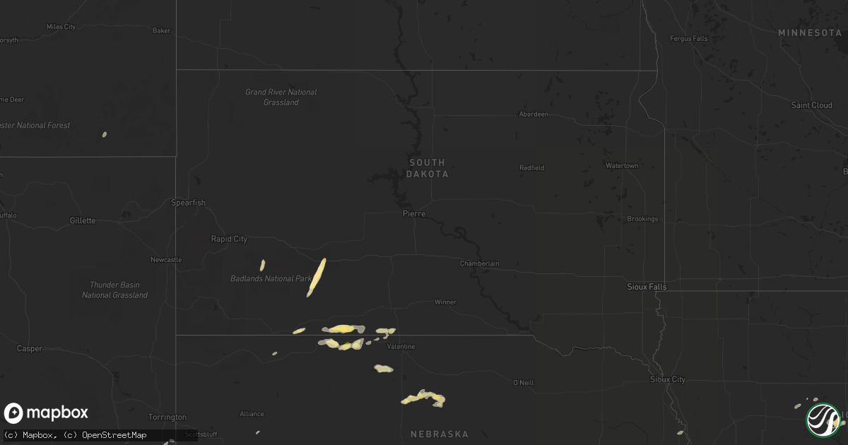
Hail Map in South Dakota on September 16, 2022
Get this storm
September 16 map
$229
one time, instant access
Download today. No call, no setup
Keep the $229
Bought the map and want the full workflow? Apply the entire $229 to a subscription within 7 days. None of it is wasted.
Every map, not just this one
This buys you this map. Subscription and you get every map we run, in the markets you choose from a few cities to whole states to nationwide. Plus real-time alerts the moment a storm fires.
Contact data
Name, contact info, occupancy, even credit band for addresses in the footprint. You go from where it hit to who to call.
Become the source they trust
Unlimited branding weather history reports on demand. You already have the documented answer ready for the property owner, and you are the one who showed up with it.
Property data and RoofTrace estimates
Pull up any address you have got, its value and the exact code rules for that jurisdiction, straight from One Click Code. Then RoofTrace estimates the squares, pitch, and roof value, priced the way you price.
Storm reports in South Dakota
South Dakota
| Date | Description |
|---|---|
| 09/16/20226:41 PM CDT | A local report indicates 60 MPH wind near 8 ESE SAINT FRANCIS |
| 09/16/20226:30 PM CDT | A local report indicates 75 MPH wind near 7 ESE ROSEBUD |
| 09/16/20225:12 PM CDT | A local report indicates 1.00 inch wind near 5 SSW TUTHILL |
| 09/16/20221:35 AM CDT | At 635 PM MDT, a severe thunderstorm was located 6 miles east of Railroad Buttes, or 30 miles southeast of Rapid City, moving north at 30 mph. HAZARD...60 mph wind gusts and penny size hail. SOURCE...Radar indicated. IMPACT...Expect damage to roofs, siding, and trees. Locations impacted include... Owanka and Wicksville. This includes Interstate 90 in South Dakota between Mile Markers 80and 97. |
| 09/16/20221:33 AM CDT | At 633 PM CDT, severe thunderstorms were located along a line extending from 8 miles northeast of Kilgore to 11 miles west of Valentine to 8 miles north of Merritt Reservoir, moving east at 55 mph. HAZARD...60 mph wind gusts and nickel size hail. SOURCE...Radar indicated. IMPACT...Expect damage to roofs, siding, and trees. Locations impacted include... Valentine, Crookston, Highway 97 crossing the Niobrara River, Anderson Bridge State Wildlife Management Area, Sparks and Smith Falls State Park.This includes the following highways... Highway 20 between mile markers 176 and 212. Highway 97 between mile markers 128 and 141. Highway 83 between mile markers 202 and 222. Highway 12 between mile markers 1 and 22. |
| 09/16/20221:28 AM CDT | At 628 PM CDT, a severe thunderstorm was located 3 miles west of Lakeview, or 16 miles southwest of Mission, moving east at 25 mph. HAZARD...60 mph wind gusts and quarter size hail. SOURCE...Radar indicated. IMPACT...Hail damage to vehicles is expected. Expect wind damage to roofs, siding, and trees. This severe thunderstorm will be near... Lakeview around 635 PM CDT.Other locations in the path of this severe thunderstorm includeSicangu Village, Littleburg and Hidden Timber. |
| 09/16/202212:58 AM CDT | At 558 PM CDT, a severe thunderstorm was located near Cody, or 30 miles southeast of Martin, moving east at 30 mph. HAZARD...60 mph wind gusts and quarter size hail. SOURCE...Radar indicated. IMPACT...Hail damage to vehicles is expected. Expect wind damage to roofs, siding, and trees. Locations impacted include... Cody, Kilgore, Nenzel, Cody Lake and Anderson Bridge State Wildlife Management Area.This includes Highway 20 between mile markers 155 and 180. |
| 09/16/202212:13 AM CDT | At 513 PM CDT, a severe thunderstorm was located near Merriman, or 18 miles south of Martin, moving east at 25 mph. HAZARD...60 mph wind gusts and half dollar size hail. SOURCE...Radar indicated. IMPACT...Hail damage to vehicles is expected. Expect wind damage to roofs, siding, and trees. Locations impacted include... Cody, Merriman and Eli. This includes the following highways... Highway 20 between mile markers 135 and 164. Highway 61 between mile markers 219 and 231. |
| 09/15/202211:23 PM CDT | At 423 PM MDT/523 PM CDT/, a severe thunderstorm was located 7 miles southwest of Harrington, or 21 miles east of Martin, moving east at 30 mph. HAZARD...Ping pong ball size hail and 60 mph wind gusts. SOURCE...Radar indicated. IMPACT...People and animals outdoors will be injured. Expect hail damage to roofs, siding, windows, and vehicles. Expect wind damage to roofs, siding, and trees. Locations impacted include... Rosebud, Saint Francis, Spring Creek, Upper Cut Meat, Soldier Creek, Lakeview, Harrington, Two Strike, Ring Thunder, Fairgrounds Housing, Grass Mountain, He Dog and western Rosebud Reservation. |
| 09/15/202211:12 PM CDT | At 412 PM MDT, a severe thunderstorm was located 8 miles northeast of Potato Creek, or 22 miles southwest of Kadoka, moving northeast at 25 mph. HAZARD...60 mph wind gusts and half dollar size hail. SOURCE...Radar indicated. IMPACT...Hail damage to vehicles is expected. Expect wind damage to roofs, siding, and trees. Locations impacted include... Intersection of Highway 73 and White River and Kadoka.This includes Interstate 90 in South Dakota between Mile Markers 136and 156. |
All States Impacted by Hail Map on September 16, 2022
Cities Impacted by Hail Map on September 16, 2022
- Fullerton, NE
- Bridgeport, NE
- Maxwell, NE
- Woodward, IA
- Blue Rapids, KS
- Frankfort, KS
- Eddyville, NE
- Hubbard, IA
- Kilgore, NE
- Belgrade, NE
- Palmer, NE
- Wolbach, NE
- Saint Paul, NE
- Franklin, NE
- Valentine, NE
- Miltonvale, KS
- Formoso, KS
- Minneola, KS
- Thedford, NE
- Cody, NE
- Batesland, SD
- Hershey, NE
- Sutherland, NE
- Grant, NE
- Brady, NE
- Dickens, NE
- Callaway, NE
- Elsie, NE
- Gothenburg, NE
- Oconto, NE
- North Platte, NE
- Wallace, NE
- Madrid, NE
- Venango, NE
- Courtland, KS
- Webber, KS
- Belleville, KS
- Republic, KS
- Ulysses, NE
- Marquette, NE
- Hordville, NE
- Clarks, NE
- Central City, NE
- Hamer, SC
- Rowland, NC
- Elsmere, NE
- Johnstown, NE
- Ainsworth, NE
- Hay Springs, NE
- Rushville, NE
- Hawk Springs, WY
- Yoder, WY
- Agra, KS
- Council Bluffs, IA
- Stapleton, NE
- Scandia, KS
- Naponee, NE
- Alma, NE
- Republican City, NE
- Bloomington, NE
- Ashland, KS
- Broadus, MT
- Tekamah, NE
- Wanblee, SD
- Interior, SD
- Marion, SC
- Kensington, KS
- Smith Center, KS
- Athol, KS
- Churdan, IA
- Paton, IA
- Minneapolis, KS
- Merriman, NE
- Norway, KS
- Mankato, KS
- Jamestown, KS
- Schuyler, NE
- Bellwood, NE
- Columbus, NE
- Howells, NE
- Rogers, NE
- Madrid, IA
- Gaylord, KS
- Westmoreland, KS
- Tuthill, SD
- Martin, SD
- Luther, IA
- Ames, IA
- Boone, IA
- Ogallala, NE
- Crookston, NE
- Mission, SD
- Saint Francis, SD
- Dayton, IA
- Harcourt, IA
- Tryon, NE
- Solomon, KS
- Scenic, SD
- Hermosa, SD
- Concordia, KS
- Glasco, KS
- Delphos, KS
- Barnard, KS
- Lincoln, KS
- Arcadia, NE
- Ord, NE
- Ansley, NE
- Gowrie, IA
- Beaver City, NE
- Norton, KS
- Hendley, NE
- Lagrange, WY
- Paxton, NE
- Burr Oak, KS
- Gretna, NE
- Phillipsburg, KS
- Cozad, NE
- Omaha, NE
- Bellevue, NE
- Lebanon, KS
- Kadoka, SD
- Julesburg, CO
- Portis, KS
- Aurora, KS
- Maxton, NC
- Simpson, KS
- Beloit, KS
- Mullins, SC
- Esbon, KS
- Riverton, NE
- Inavale, NE
- Latta, SC


