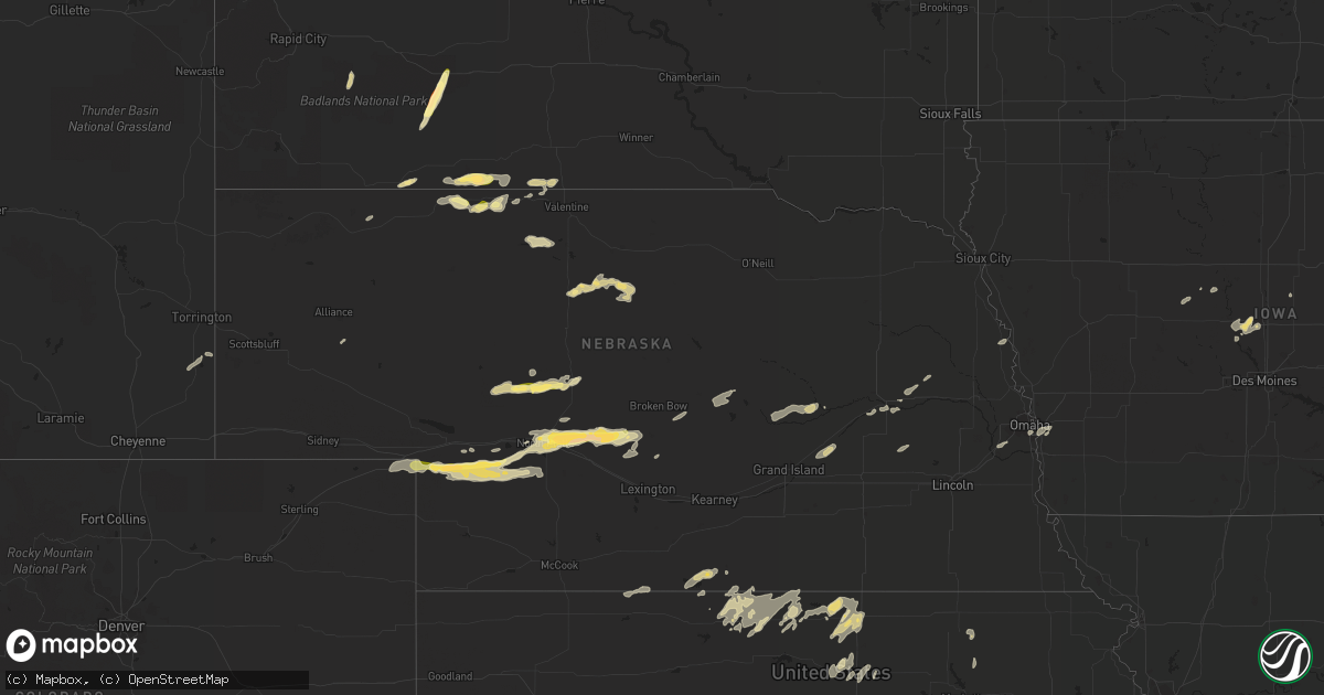
Hail Map in Nebraska on September 16, 2022
Get this storm
September 16 map
$229
one time, instant access
Download today. No call, no setup
Keep the $229
Bought the map and want the full workflow? Apply the entire $229 to a subscription within 7 days. None of it is wasted.
Every map, not just this one
This buys you this map. Subscription and you get every map we run, in the markets you choose from a few cities to whole states to nationwide. Plus real-time alerts the moment a storm fires.
Contact data
Name, contact info, occupancy, even credit band for addresses in the footprint. You go from where it hit to who to call.
Become the source they trust
Unlimited branding weather history reports on demand. You already have the documented answer ready for the property owner, and you are the one who showed up with it.
Property data and RoofTrace estimates
Pull up any address you have got, its value and the exact code rules for that jurisdiction, straight from One Click Code. Then RoofTrace estimates the squares, pitch, and roof value, priced the way you price.
Storm reports in Nebraska
Nebraska
| Date | Description |
|---|---|
| 09/16/20226:53 PM CDT | A local report indicates 1.00 inch wind near 9 N GRANT |
| 09/16/20226:30 PM CDT | Shop destroyed from high winds. Time estimated by radar. |
| 09/16/20225:15 PM CDT | A local report indicates 1.00 inch wind near 4 E MERRIMAN |
| 09/16/20226:51 AM CDT | At 1151 PM CDT, a severe thunderstorm was located near North Platte Airport, or near North Platte, moving east at 30 mph. HAZARD...Quarter size hail. SOURCE...Radar indicated. IMPACT...Damage to vehicles is expected. Locations impacted include... North Platte, Maxwell, North Platte Airport and Keith. This includes the following highways... Highway 97 between mile markers 1 and 2. Interstate 80 in Nebraska between mile markers 175 and 187. Highway 83 between mile markers 80 and 94. |
| 09/16/20224:14 AM CDT | At 914 PM CDT, a severe thunderstorm was located near North Platte Airport, or near North Platte, moving northeast at 35 mph. HAZARD...60 mph wind gusts and quarter size hail. SOURCE...Radar indicated. IMPACT...Hail damage to vehicles is expected. Expect wind damage to roofs, siding, and trees. Locations impacted include... North Platte, Maxwell, North Platte Airport and Keith. This includes the following highways... Highway 92 between mile markers 234 and 239. Highway 97 near mile marker 1. Interstate 80 in Nebraska between mile markers 180 and 186. Highway 83 between mile markers 85 and 107. |
| 09/16/20223:36 AM CDT | At 836 PM CDT/736 PM MDT/, a severe thunderstorm was located near Wallace, or 24 miles east of Grant, moving east at 35 mph. HAZARD...60 mph wind gusts and quarter size hail. SOURCE...Radar indicated. IMPACT...Hail damage to vehicles is expected. Expect wind damage to roofs, siding, and trees. Locations impacted include... Wallace, Elsie, Dickens, Grainton, Marengo and Somerset. |
| 09/16/20223:31 AM CDT | At 831 PM CDT, a severe thunderstorm was located near Sutherland Reservoir State Recreation Area, or 15 miles southwest of North Platte, moving northeast at 40 mph. HAZARD...60 mph wind gusts and quarter size hail. SOURCE...Radar indicated. IMPACT...Hail damage to vehicles is expected. Expect wind damage to roofs, siding, and trees. Locations impacted include... North Platte, Hershey, Maxwell, Sutherland Reservoir State Recreation Area, Lake Maloney State Recreation Area, North Platte Airport, Keith and Birdwood.This includes the following highways... Highway 97 between mile markers 1 and 7. Interstate 80 in Nebraska between mile markers 161 and 192. Highway 83 between mile markers 73 and 94. |
| 09/16/20223:14 AM CDT | At 814 PM CDT, a severe thunderstorm was located 16 miles northeast of Elsmere, or 18 miles south of Ainsworth, moving east at 30 mph. HAZARD...60 mph wind gusts and quarter size hail. SOURCE...Radar indicated. IMPACT...Hail damage to vehicles is expected. Expect wind damage to roofs, siding, and trees. Locations impacted include... Rose, Hofeld Lake, Raven, Duff, Sybrant, Jones Lake, Twin Lakes State Wildlife Management Area, Johnsons Corner and Pony Lake.This includes Highway 183 between mile markers 153 and 171. |
| 09/16/20223:12 AM CDT | At 812 PM CDT/712 PM MDT/, a severe thunderstorm was located near Madrid, or 8 miles northeast of Grant, moving east at 30 mph. HAZARD...60 mph wind gusts and quarter size hail. SOURCE...Radar indicated. IMPACT...Hail damage to vehicles is expected. Expect wind damage to roofs, siding, and trees. Locations impacted include... Grant, Madrid, Elsie and Grainton. This includes Highway 61 between mile markers 62 and 64. |
| 09/16/20222:54 AM CDT | At 754 PM CDT/654 PM MDT/, a severe thunderstorm was located 8 miles north of Elsie, or 21 miles northeast of Grant, moving east at 25 mph. HAZARD...Ping pong ball size hail and 60 mph wind gusts. SOURCE...Radar indicated. IMPACT...People and animals outdoors will be injured. Expect hail damage to roofs, siding, windows, and vehicles. Expect wind damage to roofs, siding, and trees. This severe thunderstorm will remain over mainly rural areas of northeastern Perkins, southeastern Keith and west central Lincoln Counties. |
| 09/16/20222:38 AM CDT | At 738 PM CDT, severe thunderstorms were located along a line extending from 7 miles southwest of Norden to near Johnstown to 19 miles west of Ainsworth, moving east at 30 mph. HAZARD...60 mph wind gusts and penny size hail. SOURCE...Radar indicated. IMPACT...Expect damage to roofs, siding, and trees. Locations impacted include... Ainsworth, Springview, Long Pine, Johnstown, Wood Lake, Keller Park State Recreation Area, Thomas Creek State Wildlife Management Area, Bobcat State Wildlife Management Area, Pine Glen State Wildlife Refuge, Antelope Peak, Meadville and North River Trail.This includes the following highways... Highway 183 between mile markers 194 and 214. Highway 20 between mile markers 212 and 255. Highway 12 between mile markers 40 and 51. |
| 09/16/20222:14 AM CDT | At 714 PM CDT, a severe thunderstorm was located 10 miles northwest of Elsmere, or 25 miles northeast of Thedford, moving east at 35 mph. HAZARD...60 mph wind gusts and quarter size hail. SOURCE...Radar indicated. IMPACT...Hail damage to vehicles is expected. Expect wind damage to roofs, siding, and trees. Locations impacted include... Hofeld Lake, Moon Lake, Raven, Willow Lake State Wildlife Management Area and Long Lake State Wildlife Management Area. |
| 09/16/20221:56 AM CDT | At 655 PM CDT, a severe thunderstorm was located near Tryon, moving east at 25 mph. HAZARD...Golf ball size hail and 60 mph wind gusts. SOURCE...Radar indicated. IMPACT...People and animals outdoors will be injured. Expect hail damage to roofs, siding, windows, and vehicles. Expect wind damage to roofs, siding, and trees. Locations impacted include... Tryon and Ringgold. This includes the following highways... Highway 92 between mile markers 195 and 227. Highway 97 between mile markers 21 and 38. |
| 09/16/20221:31 AM CDT | At 631 PM CDT, a severe thunderstorm was located 11 miles west of Tryon, moving northeast at 30 mph. HAZARD...60 mph wind gusts and quarter size hail. SOURCE...Radar indicated. IMPACT...Hail damage to vehicles is expected. Expect wind damage to roofs, siding, and trees. Locations impacted include... Tryon and Schnick Lake. This includes the following highways... Highway 92 between mile markers 187 and 214. Highway 97 between mile markers 22 and 43. |
| 09/16/20221:07 AM CDT | At 607 PM MDT, a severe thunderstorm was located near Grant, moving east at 25 mph. HAZARD...Golf ball size hail and 60 mph wind gusts. SOURCE...Radar indicated. IMPACT...People and animals outdoors will be injured. Expect hail damage to roofs, siding, windows, and vehicles. Expect wind damage to roofs, siding, and trees. Locations impacted include... Grant, Madrid, Elsie and Wild Horse Spring. This includes Highway 61 between mile markers 68 and 78. |
| 09/16/202212:15 AM CDT | At 515 PM MDT, a severe thunderstorm was located 5 miles south of Barton, or 6 miles east of Julesburg, moving east at 30 mph. HAZARD...60 mph wind gusts and quarter size hail. SOURCE...Radar indicated. IMPACT...Expect damage to roofs, siding, and trees. Hail damage to vehicles is expected. This severe thunderstorm will remain over mainly rural areas of northeastern Sedgwick County. |
| 09/15/202211:56 PM CDT | A local report indicates 1.00 inch wind near 3 ENE NORTH PLATTE |
| 09/15/202211:50 PM CDT | A local report indicates 1.00 inch wind near 1 E NORTH PLATTE |
| 09/15/202210:43 PM CDT | At 342 PM MDT/442 PM CDT/, a severe thunderstorm was located over southeastern Lacreek Wildlife Refuge, or 9 miles southeast of Martin, moving northeast at 30 mph. HAZARD...60 mph wind gusts and quarter size hail. SOURCE...Radar indicated. IMPACT...Hail damage to vehicles is expected. Expect wind damage to roofs, siding, and trees. Locations impacted include... Tuthill, Upper Cut Meat, Harrington, Vetal and Lacreek Wildlife Refuge. |
| 09/15/20229:33 PM CDT | At 233 PM MDT, a severe thunderstorm was located 3 miles southeast of Batesland, or 18 miles west of Martin, moving northeast at 30 mph. HAZARD...60 mph wind gusts and quarter size hail. SOURCE...Radar indicated. IMPACT...Hail damage to vehicles is expected. Expect wind damage to roofs, siding, and trees. Locations impacted include... Martin, Allen, Batesland, Tuthill, LaCreek North Housing, Wakpamni, Swett, Sunrise Housing, Hisle, northeastern Lacreek Wildlife Refuge and southeastern Pine Ridge Reservation. |
| 09/15/20229:25 PM CDT | A local report indicates 60 MPH wind near 7 E NORTH PLATTE |
| 09/15/20229:10 PM CDT | A local report indicates 1.00 inch wind near 4 E NORTH PLATTE |
| 09/15/20228:45 PM CDT | A local report indicates 60 MPH wind near 6 NNW WALLACE |
| 09/15/20228:20 PM CDT | A local report indicates 60 MPH wind near 21 S AINSWORTH |
| 09/15/20228:20 PM CDT | A local report indicates 1.25 inch wind near 4 NE MADRID |
| 09/15/20228:00 PM CDT | A local report indicates 1.00 inch wind near 8 NE ELSIE |
| 09/15/20227:55 PM CDT | A local report indicates 65 MPH wind near 1 N GRANT |
| 09/15/20227:15 PM CDT | A local report indicates 60 MPH wind near 2 N RINGGOLD |
| 09/15/20227:07 PM CDT | Copious amounts of quarter to half dollar size hail |
| 09/15/20227:01 PM CDT | A local report indicates 1.00 inch wind near TRYON |
All States Impacted by Hail Map on September 16, 2022
Cities Impacted by Hail Map on September 16, 2022
- Fullerton, NE
- Bridgeport, NE
- Maxwell, NE
- Woodward, IA
- Blue Rapids, KS
- Frankfort, KS
- Eddyville, NE
- Hubbard, IA
- Kilgore, NE
- Belgrade, NE
- Palmer, NE
- Wolbach, NE
- Saint Paul, NE
- Franklin, NE
- Valentine, NE
- Miltonvale, KS
- Formoso, KS
- Minneola, KS
- Thedford, NE
- Cody, NE
- Batesland, SD
- Hershey, NE
- Sutherland, NE
- Grant, NE
- Brady, NE
- Dickens, NE
- Callaway, NE
- Elsie, NE
- Gothenburg, NE
- Oconto, NE
- North Platte, NE
- Wallace, NE
- Madrid, NE
- Venango, NE
- Courtland, KS
- Webber, KS
- Belleville, KS
- Republic, KS
- Ulysses, NE
- Marquette, NE
- Hordville, NE
- Clarks, NE
- Central City, NE
- Hamer, SC
- Rowland, NC
- Elsmere, NE
- Johnstown, NE
- Ainsworth, NE
- Hay Springs, NE
- Rushville, NE
- Hawk Springs, WY
- Yoder, WY
- Agra, KS
- Council Bluffs, IA
- Stapleton, NE
- Scandia, KS
- Naponee, NE
- Alma, NE
- Republican City, NE
- Bloomington, NE
- Ashland, KS
- Broadus, MT
- Tekamah, NE
- Wanblee, SD
- Interior, SD
- Marion, SC
- Kensington, KS
- Smith Center, KS
- Athol, KS
- Churdan, IA
- Paton, IA
- Minneapolis, KS
- Merriman, NE
- Norway, KS
- Mankato, KS
- Jamestown, KS
- Schuyler, NE
- Bellwood, NE
- Columbus, NE
- Howells, NE
- Rogers, NE
- Madrid, IA
- Gaylord, KS
- Westmoreland, KS
- Tuthill, SD
- Martin, SD
- Luther, IA
- Ames, IA
- Boone, IA
- Ogallala, NE
- Crookston, NE
- Mission, SD
- Saint Francis, SD
- Dayton, IA
- Harcourt, IA
- Tryon, NE
- Solomon, KS
- Scenic, SD
- Hermosa, SD
- Concordia, KS
- Glasco, KS
- Delphos, KS
- Barnard, KS
- Lincoln, KS
- Arcadia, NE
- Ord, NE
- Ansley, NE
- Gowrie, IA
- Beaver City, NE
- Norton, KS
- Hendley, NE
- Lagrange, WY
- Paxton, NE
- Burr Oak, KS
- Gretna, NE
- Phillipsburg, KS
- Cozad, NE
- Omaha, NE
- Bellevue, NE
- Lebanon, KS
- Kadoka, SD
- Julesburg, CO
- Portis, KS
- Aurora, KS
- Maxton, NC
- Simpson, KS
- Beloit, KS
- Mullins, SC
- Esbon, KS
- Riverton, NE
- Inavale, NE
- Latta, SC


