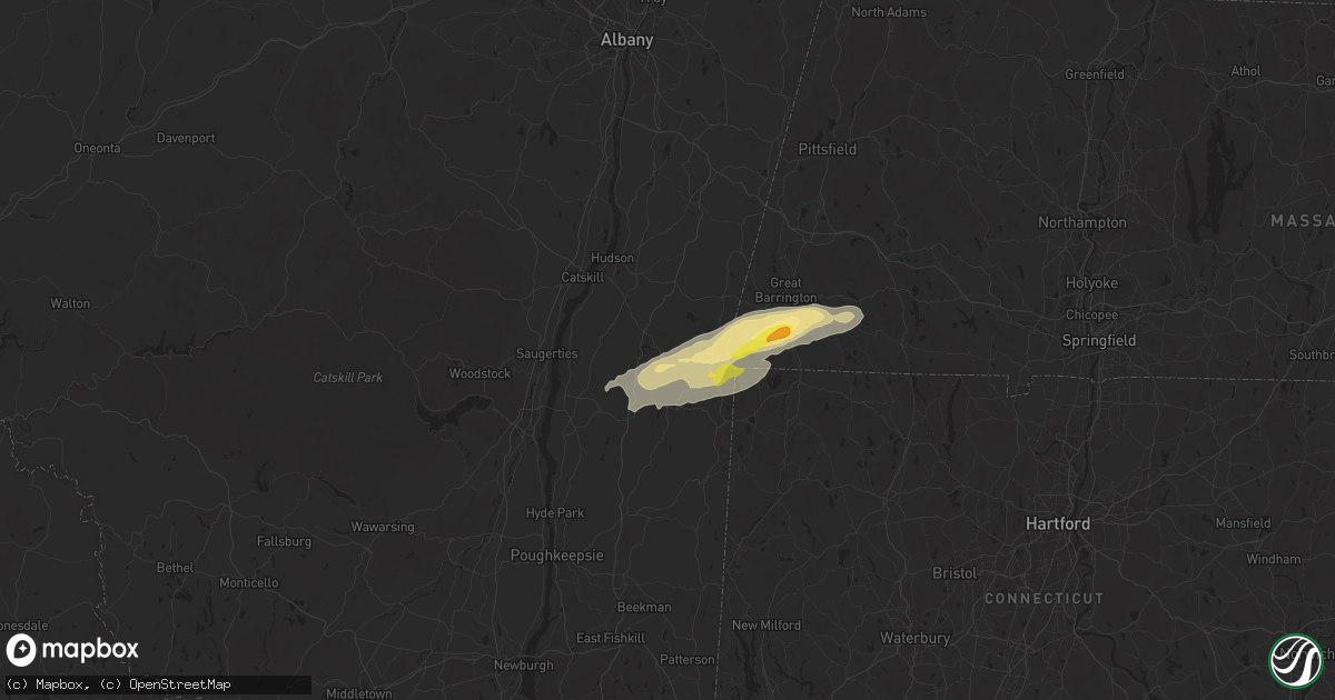
Hail Map in Ancram, NY on September 6, 2025
Get this storm
September 6 map
$229
one time, instant access
Download today. No call, no setup
Keep the $229
Bought the map and want the full workflow? Apply the entire $229 to a subscription within 7 days. None of it is wasted.
Every map, not just this one
This buys you this map. Subscription and you get every map we run, in the markets you choose from a few cities to whole states to nationwide. Plus real-time alerts the moment a storm fires.
Contact data
Name, contact info, occupancy, even credit band for addresses in the footprint. You go from where it hit to who to call.
Become the source they trust
Unlimited branding weather history reports on demand. You already have the documented answer ready for the property owner, and you are the one who showed up with it.
Property data and RoofTrace estimates
Pull up any address you have got, its value and the exact code rules for that jurisdiction, straight from One Click Code. Then RoofTrace estimates the squares, pitch, and roof value, priced the way you price.
Storm reports in Ancram, NY
Ancram, NY
| Date | Description |
|---|---|
| 09/06/20251:06 PM CDT | Tree down over the roadway near intersection of county road 7 and hall hill rd. |
| 09/06/202512:54 PM CDT | Multiple trees down per 911 dispatch near state route 82 and wiltsie bridge rd in town on ancram. |
| 09/06/202512:39 PM CDT | Tree down over the roadway near intersection of county road 7 and hall hill rd. |
| 09/06/202512:38 PM CDT | Social media report and photo of a few trees down on county route 7 just west of elsohn road near gallatin. |
All States Impacted by Hail Map on September 6, 2025
All Cities Impacted by Hail Map on September 6, 2025
- Grant, OK
- Hugo, OK
- South Hutchinson, KS
- Rhinebeck, NY
- Red Hook, NY
- Stanfordville, NY
- Pine Plains, NY
- Ancramdale, NY
- Ancram, NY
- Millerton, NY
- Copake, NY
- Copake Falls, NY
- Marion, AL
- Lakeville, CT
- Salisbury, CT
- South Egremont, MA
- Sheffield, MA
- Great Barrington, MA
- Canaan, CT
- Ashley Falls, MA
- East Canaan, CT
- Southfield, MA
- Mill River, MA
- Norfolk, CT
- Falls Village, CT
- Sandisfield, MA
- Monterey, MA
- Kennesaw, GA
- Acworth, GA
- New Hope, PA
- Lambertville, NJ
- Stockton, NJ
- Ringoes, NJ
- Otis, MA
- Colebrook, CT
- East Otis, MA
- Granville, MA
- Blandford, MA
- Greensboro, NC
- Riverton, CT
- West Hartland, CT
- East Hartland, CT
- Comstock, TX
- Pawling, NY
- Poughquag, NY
- Wingdale, NY
- Dover Plains, NY
- Hopewell, NJ
- Flemington, NJ
- Hillsborough, NJ
- Woodstock, GA
- North Granby, CT
- Russell, MA
- Westfield, MA
- Southwick, MA
- Somerset, NJ
- South Kent, CT
- Belle Mead, NJ
- Skillman, NJ
- New Milford, CT
- Gaylordsville, CT
- Kent, CT
- Marietta, GA
- New Preston Marble Dale, CT
- Sherman, CT
- Feeding Hills, MA
- West Springfield, MA
- Southampton, MA
- Holyoke, MA
- Easthampton, MA
- Huntington, MA
- Agawam, MA
- Springfield, MA
- Chicopee, MA
- Scotch Plains, NJ
- Cornwall Bridge, CT
- Bernardston, MA
- Gill, MA
- Northfield, MA
- King William, VA
- Aylett, VA
- Blanch, NC
- Milton, NC
- Upper Falls, MD
- Joppa, MD
- Kingsville, MD
- Plainfield, NJ
- Bantam, CT
- Washington Depot, CT
- Piscataway, NJ
- Dunellen, NJ
- White Marsh, MD
- Abingdon, MD
- Bel Air, MD
- Edgewood, MD
- Middle River, MD
- New Brunswick, NJ
- Yanceyville, NC
- Brookfield, CT
- Bridgewater, CT
- Warwick, MA
- Edison, NJ
- Del Rio, TX
- Manquin, VA
- Semora, NC
- Alton, VA
- Litchfield, CT
- Morris, CT
- Fords, NJ
- Metuchen, NJ
- Iselin, NJ
- Woodbridge, NJ
- Perth Amboy, NJ
- Avenel, NJ
- Sewaren, NJ
- Highland Park, NJ
- Port Reading, NJ
- Fallston, MD
- Churchville, MD
- Aberdeen, MD
- Darlington, MD
- Havre De Grace, MD
- Street, MD
- South Hadley, MA
- Wilbraham, MA
- Indian Orchard, MA
- Monson, MA
- Ludlow, MA
- Longmeadow, MA
- Palmer, MA
- Three Rivers, MA
- Belchertown, MA
- Bondsville, MA
- Granby, MA
- Thorndike, MA
- Hogansville, GA
- Roxbury, CT
- Jemison, AL
- Thorsby, AL
- Winchendon, MA
- Colora, MD
- Conowingo, MD
- Carteret, NJ
- Winchester, NH
- Hinsdale, NH
- Fitzwilliam, NH
- Troy, NH
- Fiskdale, MA
- West Warren, MA
- Ware, MA
- Warren, MA
- Brimfield, MA
- West Brookfield, MA
- Brookfield, MA
- Sturbridge, MA
- East Brookfield, MA
- Gilbertville, MA
- North Brookfield, MA
- New Braintree, MA
- Rising Sun, MD
- Peach Bottom, PA
- Nottingham, PA
- Athol, MA
- Baldwinville, MA
- Templeton, MA
- Gardner, MA
- Ashburnham, MA
- Rindge, NH
- New Ipswich, NH
- Ashby, MA
- Gilmanton Iron Works, NH
- Center Barnstead, NH
- Alton, NH
- Gilmanton, NH
- Hooksett, NH
- Candia, NH
- Suncook, NH
- Epsom, NH
- Deerfield, NH
- Northwood, NH
- Nottingham, NH
- Royalston, MA
- Greenfield, MA
- Westfield, NJ
- Millers Falls, MA
- Wendell, MA
- Montague, MA
- Shelby, NC
- Chatsworth, NJ
- Turners Falls, MA
- Orange, MA
- Clanton, AL
- Merrimack, NH
- Bedford, NH
- Skipwith, VA
- Red Oak, VA
- Westminster, SC
- Manchester, NH
- Londonderry, NH
- Auburn, NH
- Charlton, MA
- Spencer, MA
- Rochdale, MA
- Leicester, MA
- Oakham, MA
- Paxton, MA
- Alton Bay, NH
- Strafford, NH
- Barrington, NH
- Rochester, NH
- Raymond, NH
- Chester, NH
- Holden, MA
- Cornish, ME
- West Baldwin, ME
- Walhalla, SC
- Chase City, VA
- Woodville, VA
- Washington, VA
- Litchfield, NH
- Wylliesburg, VA
- Sperryville, VA
- Parsonsfield, ME
- Limington, ME
- Seneca, SC
- West Union, SC
- East Baldwin, ME
- Castleton, VA
- Amissville, VA
- Oxford, PA
- Cherry Valley, MA
- Worcester, MA
- Boylston, MA
- Shrewsbury, MA
- West Boylston, MA
- Northborough, MA
- Marlborough, MA
- Stow, MA
- Hudson, MA
- Berlin, MA
- Bolton, MA
- Jefferson, MA
- Clinton, MA
- Pecos, NM
- Chestertown, MD
- Worton, MD
- Warrenton, VA
- Marshall, VA
- Jeffersonton, VA
- Brackettville, TX
- Goffstown, NH
- Millington, MD
- Kennedyville, MD
- Juliette, GA
- Barnesville, GA
- Arlington, VA
- Alexandria, VA
- Washington, DC
- Naval Anacost Annex, DC
- Oxon Hill, MD
- Suitland, MD
- Temple Hills, MD
- Fort Washington, MD
- Clinton, MD
- Sudbury, MA
- Maynard, MA
- Shorter, AL
- Cecil, AL
- Pike Road, AL
- Derry, NH
- Windham, NH
- Amherst, NH
- Forsyth, GA
- Church Hill, MD
- Centreville, MD
- Charles City, VA
- Sudlersville, MD
- Lanexa, VA
- Eatonton, GA
- Townsend, DE
- Massey, MD
- Galena, MD
- Clayton, DE
- Mayer, AZ
- Barclay, MD
- Estancia, NM
- Henderson, NV
- Pylesville, MD
- Marydel, MD
- Hartly, DE
- Smyrna, DE
- Ingleside, MD
- Perry Hall, MD
- Moore, SC
- Woodruff, SC
- Nogales, AZ
- Vaughn, NM
- Murphy, ID
- Grand View, ID
- Bend, OR
- Sisters, OR
- Thoreau, NM
- Green Valley, AZ
- Amado, AZ
- Maupin, OR
- Grants, NM
- Casa Blanca, NM
- Cubero, NM
- Tucson, AZ
- Roma, TX
- Veguita, NM
- Belen, NM
- Socorro, NM
- Peralta, NM
- Bosque Farms, NM
- Los Lunas, NM
- Lincoln, MA
- Concord, MA
- Hanscom Afb, MA
- Bedford, MA
- Acton, MA
- Lexington, MA
- Burlington, MA
- Woburn, MA
- Winchester, MA
- Reading, MA
- Wilmington, MA
- Billerica, MA
- Southbury, CT


