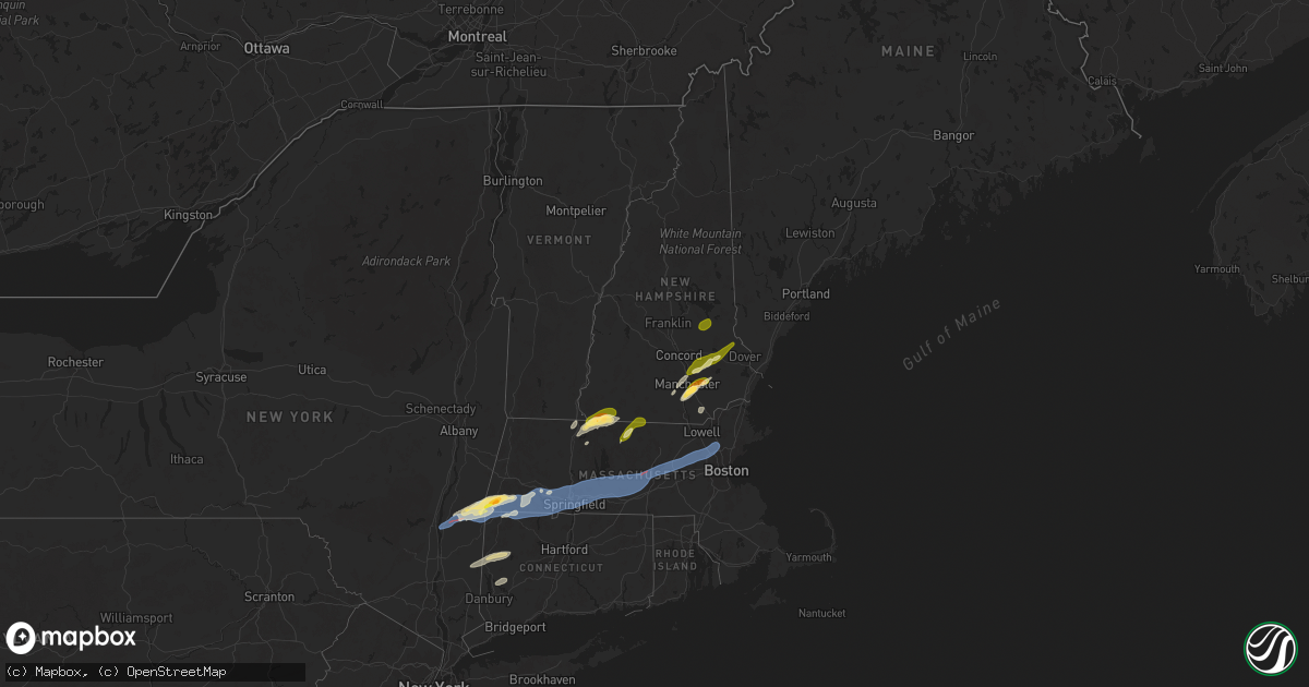
Hail Map in New Hampshire on September 6, 2025
Get this storm
September 6 map
$229
one time, instant access
Download today. No call, no setup
Keep the $229
Bought the map and want the full workflow? Apply the entire $229 to a subscription within 7 days. None of it is wasted.
Every map, not just this one
This buys you this map. Subscription and you get every map we run, in the markets you choose from a few cities to whole states to nationwide. Plus real-time alerts the moment a storm fires.
Contact data
Name, contact info, occupancy, even credit band for addresses in the footprint. You go from where it hit to who to call.
Become the source they trust
Unlimited branding weather history reports on demand. You already have the documented answer ready for the property owner, and you are the one who showed up with it.
Property data and RoofTrace estimates
Pull up any address you have got, its value and the exact code rules for that jurisdiction, straight from One Click Code. Then RoofTrace estimates the squares, pitch, and roof value, priced the way you price.
Storm reports in New Hampshire
New Hampshire
| Date | Description |
|---|---|
| 09/06/20253:55 PM CDT | Social media photo of a toppled large tree partially blocking vespa lane. |
| 09/06/20253:20 PM CDT | Quarter-sized hail |
| 09/06/20253:20 PM CDT | Quarter-sized hail fell for 5-6 min. Time estimated by radar. |
| 09/06/20253:17 PM CDT | Two mature trees down. Time estimated from radar. |
| 09/06/20253:15 PM CDT | Tree down on nh-3 in litchfield. Time estimated by radar. |
| 09/06/20253:12 PM CDT | Large oak tree down on a house. Several other large trees are also down in the area. Time estimated from radar. |
| 09/06/20253:10 PM CDT | Off-duty firefighter reports a large tree downed partially blocking epping st. Time estimated by radar. |
| 09/06/20253:09 PM CDT | Corrects previous tstm wnd dmg report from 3 n nashua. Social media photo of a toppled large tree partially blocking vespa lane. Time estimated from radar. |
| 09/06/20253:05 PM CDT | Delayed report...large trees down on eastern shore of ayers lake. Time estimated by radar. |
| 09/06/20253:05 PM CDT | Corrects previous tstm wnd dmg report from 2 n barrington. Trees down in the area including barrington fire reporting a tree down on a house on small rd. Time estimated |
| 09/06/20253:05 PM CDT | Barrington fire reporting a tree down on a house on small rd. Time estimated by radar. |
| 09/06/20253:05 PM CDT | Trees and large branches downed across the south side of milford. Time estimated by radar. |
| 09/06/20252:52 PM CDT | Corrects previous hail report from 4 se manchester. Hail as big as 1.5 inches fell southeast of manchester. Hail began at 3:52pm and lasted for up to 10 mins. Cracked a |
| 09/06/20252:42 PM CDT | Hail as big as 1.5 inches fell southeast of manchester. Hail began at 3:42pm and lasted for up to 10 mins. Cracked a windshield. Observed shredded leaves and branches a |
| 09/06/20252:40 PM CDT | Measured quarter-sized hail which lasted for 8 minutes. Hail accumulated in areas of lawn. Leaves and a few branches knocked down. Time estimated by radar. |
| 09/06/20252:40 PM CDT | Merrimack fire reported a tree down on a house on kinsman ln. No injuries. Time estimated by radar. |
| 09/06/20252:40 PM CDT | Allenstown fire reports a tree down onto wires and house on deerfield rd. No injuries. Time estimated by radar. |
| 09/06/20252:35 PM CDT | Reports of downed trees and wires on west side of henniker. Time estimated by radar. |
| 09/06/20252:25 PM CDT | Hail observed in a food store parking lot. Most stones were quarter-sized. Time estimated by radar. |
| 09/06/20252:25 PM CDT | Large tree down on a car in hooksett. Time estimated by radar. |
| 09/06/20252:20 PM CDT | Observed numerous trees downed in the town of fitzwilliam. Time estimated by radar. |
| 09/06/20252:15 PM CDT | Numerous trees down in richmond--observed at least 10. Largest trees were about 16 inches in diameter. Time estimated by radar. |
| 09/06/20252:05 PM CDT | Hail as large as ping pong balls fell for almost 10 mins. Time estimated by radar. |
| 09/06/20251:40 PM CDT | Three trees down on north ashland road in plymouth. Largest was about 10 inches. Time estimated by radar. |
| 09/06/20251:40 PM CDT | Off-duty firefighter reported a tree down on wires along nh-175. Time estimated by radar. |
All States Impacted by Hail Map on September 6, 2025
Cities Impacted by Hail Map on September 6, 2025
- Grant, OK
- Hugo, OK
- South Hutchinson, KS
- Rhinebeck, NY
- Red Hook, NY
- Stanfordville, NY
- Pine Plains, NY
- Ancramdale, NY
- Ancram, NY
- Millerton, NY
- Copake, NY
- Copake Falls, NY
- Marion, AL
- Lakeville, CT
- Salisbury, CT
- South Egremont, MA
- Sheffield, MA
- Great Barrington, MA
- Canaan, CT
- Ashley Falls, MA
- East Canaan, CT
- Southfield, MA
- Mill River, MA
- Norfolk, CT
- Falls Village, CT
- Sandisfield, MA
- Monterey, MA
- Kennesaw, GA
- Acworth, GA
- New Hope, PA
- Lambertville, NJ
- Stockton, NJ
- Ringoes, NJ
- Otis, MA
- Colebrook, CT
- East Otis, MA
- Granville, MA
- Blandford, MA
- Greensboro, NC
- Riverton, CT
- West Hartland, CT
- East Hartland, CT
- Comstock, TX
- Pawling, NY
- Poughquag, NY
- Wingdale, NY
- Dover Plains, NY
- Hopewell, NJ
- Flemington, NJ
- Hillsborough, NJ
- Woodstock, GA
- North Granby, CT
- Russell, MA
- Westfield, MA
- Southwick, MA
- Somerset, NJ
- South Kent, CT
- Belle Mead, NJ
- Skillman, NJ
- New Milford, CT
- Gaylordsville, CT
- Kent, CT
- Marietta, GA
- New Preston Marble Dale, CT
- Sherman, CT
- Feeding Hills, MA
- West Springfield, MA
- Southampton, MA
- Holyoke, MA
- Easthampton, MA
- Huntington, MA
- Agawam, MA
- Springfield, MA
- Chicopee, MA
- Scotch Plains, NJ
- Cornwall Bridge, CT
- Bernardston, MA
- Gill, MA
- Northfield, MA
- King William, VA
- Aylett, VA
- Blanch, NC
- Milton, NC
- Upper Falls, MD
- Joppa, MD
- Kingsville, MD
- Plainfield, NJ
- Bantam, CT
- Washington Depot, CT
- Piscataway, NJ
- Dunellen, NJ
- White Marsh, MD
- Abingdon, MD
- Bel Air, MD
- Edgewood, MD
- Middle River, MD
- New Brunswick, NJ
- Yanceyville, NC
- Brookfield, CT
- Bridgewater, CT
- Warwick, MA
- Edison, NJ
- Del Rio, TX
- Manquin, VA
- Semora, NC
- Alton, VA
- Litchfield, CT
- Morris, CT
- Fords, NJ
- Metuchen, NJ
- Iselin, NJ
- Woodbridge, NJ
- Perth Amboy, NJ
- Avenel, NJ
- Sewaren, NJ
- Highland Park, NJ
- Port Reading, NJ
- Fallston, MD
- Churchville, MD
- Aberdeen, MD
- Darlington, MD
- Havre De Grace, MD
- Street, MD
- South Hadley, MA
- Wilbraham, MA
- Indian Orchard, MA
- Monson, MA
- Ludlow, MA
- Longmeadow, MA
- Palmer, MA
- Three Rivers, MA
- Belchertown, MA
- Bondsville, MA
- Granby, MA
- Thorndike, MA
- Hogansville, GA
- Roxbury, CT
- Jemison, AL
- Thorsby, AL
- Winchendon, MA
- Colora, MD
- Conowingo, MD
- Carteret, NJ
- Winchester, NH
- Hinsdale, NH
- Fitzwilliam, NH
- Troy, NH
- Fiskdale, MA
- West Warren, MA
- Ware, MA
- Warren, MA
- Brimfield, MA
- West Brookfield, MA
- Brookfield, MA
- Sturbridge, MA
- East Brookfield, MA
- Gilbertville, MA
- North Brookfield, MA
- New Braintree, MA
- Rising Sun, MD
- Peach Bottom, PA
- Nottingham, PA
- Athol, MA
- Baldwinville, MA
- Templeton, MA
- Gardner, MA
- Ashburnham, MA
- Rindge, NH
- New Ipswich, NH
- Ashby, MA
- Gilmanton Iron Works, NH
- Center Barnstead, NH
- Alton, NH
- Gilmanton, NH
- Hooksett, NH
- Candia, NH
- Suncook, NH
- Epsom, NH
- Deerfield, NH
- Northwood, NH
- Nottingham, NH
- Royalston, MA
- Greenfield, MA
- Westfield, NJ
- Millers Falls, MA
- Wendell, MA
- Montague, MA
- Shelby, NC
- Chatsworth, NJ
- Turners Falls, MA
- Orange, MA
- Clanton, AL
- Merrimack, NH
- Bedford, NH
- Skipwith, VA
- Red Oak, VA
- Westminster, SC
- Manchester, NH
- Londonderry, NH
- Auburn, NH
- Charlton, MA
- Spencer, MA
- Rochdale, MA
- Leicester, MA
- Oakham, MA
- Paxton, MA
- Alton Bay, NH
- Strafford, NH
- Barrington, NH
- Rochester, NH
- Raymond, NH
- Chester, NH
- Holden, MA
- Cornish, ME
- West Baldwin, ME
- Walhalla, SC
- Chase City, VA
- Woodville, VA
- Washington, VA
- Litchfield, NH
- Wylliesburg, VA
- Sperryville, VA
- Parsonsfield, ME
- Limington, ME
- Seneca, SC
- West Union, SC
- East Baldwin, ME
- Castleton, VA
- Amissville, VA
- Oxford, PA
- Cherry Valley, MA
- Worcester, MA
- Boylston, MA
- Shrewsbury, MA
- West Boylston, MA
- Northborough, MA
- Marlborough, MA
- Stow, MA
- Hudson, MA
- Berlin, MA
- Bolton, MA
- Jefferson, MA
- Clinton, MA
- Pecos, NM
- Chestertown, MD
- Worton, MD
- Warrenton, VA
- Marshall, VA
- Jeffersonton, VA
- Brackettville, TX
- Goffstown, NH
- Millington, MD
- Kennedyville, MD
- Juliette, GA
- Barnesville, GA
- Arlington, VA
- Alexandria, VA
- Washington, DC
- Naval Anacost Annex, DC
- Oxon Hill, MD
- Suitland, MD
- Temple Hills, MD
- Fort Washington, MD
- Clinton, MD
- Sudbury, MA
- Maynard, MA
- Shorter, AL
- Cecil, AL
- Pike Road, AL
- Derry, NH
- Windham, NH
- Amherst, NH
- Forsyth, GA
- Church Hill, MD
- Centreville, MD
- Charles City, VA
- Sudlersville, MD
- Lanexa, VA
- Eatonton, GA
- Townsend, DE
- Massey, MD
- Galena, MD
- Clayton, DE
- Mayer, AZ
- Barclay, MD
- Estancia, NM
- Henderson, NV
- Pylesville, MD
- Marydel, MD
- Hartly, DE
- Smyrna, DE
- Ingleside, MD
- Perry Hall, MD
- Moore, SC
- Woodruff, SC
- Nogales, AZ
- Vaughn, NM
- Murphy, ID
- Grand View, ID
- Bend, OR
- Sisters, OR
- Thoreau, NM
- Green Valley, AZ
- Amado, AZ
- Maupin, OR
- Grants, NM
- Casa Blanca, NM
- Cubero, NM
- Tucson, AZ
- Roma, TX
- Veguita, NM
- Belen, NM
- Socorro, NM
- Peralta, NM
- Bosque Farms, NM
- Los Lunas, NM
- Lincoln, MA
- Concord, MA
- Hanscom Afb, MA
- Bedford, MA
- Acton, MA
- Lexington, MA
- Burlington, MA
- Woburn, MA
- Winchester, MA
- Reading, MA
- Wilmington, MA
- Billerica, MA
- Southbury, CT


