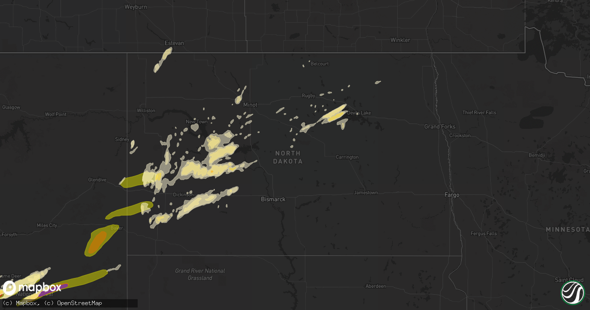
Hail Map in North Dakota on September 5, 2015
Get this storm
September 5 map
$229
one time, instant access
Download today. No call, no setup
Keep the $229
Bought the map and want the full workflow? Apply the entire $229 to a subscription within 7 days. None of it is wasted.
Every map, not just this one
This buys you this map. Subscription and you get every map we run, in the markets you choose from a few cities to whole states to nationwide. Plus real-time alerts the moment a storm fires.
Contact data
Name, contact info, occupancy, even credit band for addresses in the footprint. You go from where it hit to who to call.
Become the source they trust
Unlimited branding weather history reports on demand. You already have the documented answer ready for the property owner, and you are the one who showed up with it.
Property data and RoofTrace estimates
Pull up any address you have got, its value and the exact code rules for that jurisdiction, straight from One Click Code. Then RoofTrace estimates the squares, pitch, and roof value, priced the way you price.
Storm reports in North Dakota
North Dakota
| Date | Description |
|---|---|
| 09/05/20152:26 AM CDT | Partially built garage was damaged by the strong winds. |
| 09/05/20151:55 AM CDT | Measured wind gust from mafb observation site. |
| 09/05/20151:42 AM CDT | Measured wind gust from mafb observation site. |
| 09/05/201512:03 AM CDT | A pole barn with a shed attached was blown over onto a vehicle...smashing the roof. Another shed attached to a building was destroyed |
| 09/05/201512:03 AM CDT | A pole barn with a shed attached was blown over onto a vehicle...smashing the roof. Another shed attached to a building was destroyed |
| 09/05/201512:00 AM CDT | A local report indicates 60 MPH wind near GRASSY BUTTE |
| 09/04/201511:45 PM CDT | Hail to the size of quarters lasted 5 minutes. |
| 09/04/201511:10 PM CDT | Approximately two dozen telephone poles were snapped. An empty grain bin was displaced 80 to 100 yards and destroyed. Winds estimated at 80 mph. |
| 09/04/201510:49 PM CDT | Hail lasted about 3 minutes until 1052 pm cdt. Wind gusts 30 to 40 mph. |
All States Impacted by Hail Map on September 5, 2015
Cities Impacted by Hail Map on September 5, 2015
- Dodge, ND
- Hazen, ND
- Garrison, ND
- Golden Valley, ND
- Zap, ND
- Beulah, ND
- Halliday, ND
- Skipperville, AL
- Ariton, AL
- Ozark, AL
- Sentinel Butte, ND
- Rhame, ND
- New England, ND
- Amidon, ND
- Medora, ND
- Birney, MT
- Taylor, ND
- Killdeer, ND
- Manning, ND
- Dunn Center, ND
- Gladstone, ND
- Otter, MT
- Lodge Grass, MT
- Churchs Ferry, ND
- Devils Lake, ND
- Esmond, ND
- Maddock, ND
- Minnewaukan, ND
- Penn, ND
- Saucier, MS
- Busby, MT
- Decker, MT
- Wyola, MT
- Keysville, GA
- Hephzibah, GA
- Pensacola, FL
- Brainerd, MN
- Picayune, MS
- Kiln, MS
- Panama City, FL
- Plaza, ND
- Parshall, ND
- Grant Park, IL
- Cartwright, ND
- Douglas, ND
- Minot, ND
- Alsen, ND
- Edmore, ND
- Osnabrock, ND
- Nekoma, ND
- Bay Minette, AL
- Monterey, TN
- Keene, ND
- Fairfield, ND
- Belfield, ND
- Scottsburg, IN
- Austin, IN
- Goshen, KY
- Seymour, IN
- Brownstown, IN
- Hammond, MT
- Ekalaka, MT
- Stanton, ND
- York, ND
- Fairland, IN
- Franklin, IN
- Boggstown, IN
- Needham, IN
- Gulfport, MS
- Sylacauga, AL
- Childersburg, AL
- Cicero, IL
- Valparaiso, IN
- Westville, IN
- East Chicago, IN
- Portage, IN
- Hobart, IN
- Lake Station, IN
- Chesterton, IN
- Gary, IN
- Hammond, IN
- Michigan City, IN
- Chicago, IL
- Beverly Shores, IN
- Miami, FL
- Quincy, FL
- Freetown, IN
- Anderson, IN
- Pendleton, IN
- Markleville, IN
- Crosby, ND
- Noonan, ND
- Monrovia, IN
- Baton Rouge, LA
- New Salem, ND
- Glen Ullin, ND
- Clayton, IN
- Augusta, GA
- Milroy, IN
- Greensburg, IN
- Lefor, ND
- Dickinson, ND
- Henryville, IN
- Borden, IN
- Lame Deer, MT
- Ashland, MT
- Des Lacs, ND
- Ellijay, GA
- Bowman, ND
- Sneedville, TN
- Thorn Hill, TN
- Attica, IN
- Otterbein, IN
- Floyds Knobs, IN
- Memphis, IN
- Sellersburg, IN
- Ohatchee, AL
- Beach, ND
- Jamestown, TN
- Ryder, ND
- Richardton, ND
- Ochlocknee, GA
- Rugby, ND
- Lovell, WY
- Campbellsburg, IN
- Vallonia, IN
- Otisco, IN
- Charlestown, IN
- Shelbyville, IN
- Volborg, MT
- Durango, CO
- Covington, LA
- Abita Springs, LA
- Summersville, WV
- Live Oak, FL
- Donovan, IL
- Morocco, IN
- South Heart, ND
- Max, ND
- Oberon, ND
- Carriere, MS
- Roseglen, ND
- Glenburn, ND
- Tignall, GA
- Stilesville, IN
- Burlington, ND
- Berthold, ND
- Statesboro, GA
- Weaver, AL
- Anniston, AL
- Jacksonville, AL
- Alexandria, AL
- New Palestine, IN
- Fountaintown, IN
- Indianapolis, IN
- Greenfield, IN
- Wellington, IL
- Hoopeston, IL
- Franklinton, LA
- Folsom, LA
- Mooresburg, TN
- Rogersville, TN
- Milford, IL
- Starkweather, ND
- Garryowen, MT
- Aurora, IN
- Silverhill, AL
- Robertsdale, AL
- Karlsruhe, ND
- Balfour, ND
- Pine Village, IN
- Dunseith, ND
- Wewahitchka, FL
- Calera, AL
- Alabaster, AL
- Talladega, AL
- Grassy Butte, ND
- Alamo, ND
- Motley, MN
- Cushing, MN
- Harvey, ND
- Martin, ND
- Hamilton, OH
- Havana, FL
- Browerville, MN
- Long Prairie, MN
- Pass Christian, MS
- Biloxi, MS
- Mccordsville, IN
- Fortville, IN
- Commiskey, IN
- Watford City, ND
- Poplarville, MS
- Ironton, MN
- Frankfort, KY
- New Town, ND
- Mandaree, ND
- Drake, ND
- Cairo, GA
- Thomasville, GA
- Wilmington, IL
- Wibaux, MT
- Leeds, ND
- Hebron, ND
- Regent, ND
- Crothersville, IN
- Anamoose, ND
- Bessemer, AL
- Perkinston, MS
- Watseka, IL
- Sheldon, IL
- Cass Lake, MN
- Walker, MN
- Laporte, MN
- Lake City, FL
- Mcclusky, ND
- Denhoff, ND
- Homestead, FL
- Waynesboro, GA
- Greybull, WY
- Wolford, ND
- Knox, ND
- Bush, LA
- Bogalusa, LA
- Underwood, ND
- Washburn, ND
- Bryson City, NC
- Roseboro, NC
- Fowler, IN
- Oxford, IN
- Medora, IN
- Stockton, AL
- Stanley, ND
- Cando, ND
- Hollywood, FL
- Saint Gabriel, LA
- Cookeville, TN
- Lillian, AL
- Benedict, ND
- Granville, ND
- Saint Paul, IN
- Rocky Ford, GA
- Sylvania, GA
- Crow Agency, MT
- Columbiana, AL
- Crossville, TN
- Franklin, NC
- Greenville, AL
- Connersville, IN
- Fairfield, OH
- Eastanollee, GA
- Orleans, IN
- Grand Bay, AL
- Crawford, TN
- McHenry, MS
- Broadus, MT
- Olive, MT
- Biddle, MT
- Boyes, MT
- Plevna, MT
- Ismay, MT
- Baker, MT
- Willard, MT
- Golva, ND


