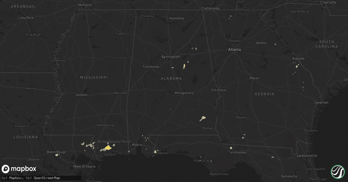
Hail Map in Alabama on September 5, 2015
Get this storm
September 5 map
$229
one time, instant access
Download today. No call, no setup
Keep the $229
Bought the map and want the full workflow? Apply the entire $229 to a subscription within 7 days. None of it is wasted.
Every map, not just this one
This buys you this map. Subscription and you get every map we run, in the markets you choose from a few cities to whole states to nationwide. Plus real-time alerts the moment a storm fires.
Contact data
Name, contact info, occupancy, even credit band for addresses in the footprint. You go from where it hit to who to call.
Become the source they trust
Unlimited branding weather history reports on demand. You already have the documented answer ready for the property owner, and you are the one who showed up with it.
Property data and RoofTrace estimates
Pull up any address you have got, its value and the exact code rules for that jurisdiction, straight from One Click Code. Then RoofTrace estimates the squares, pitch, and roof value, priced the way you price.
Storm reports in Alabama
Alabama
| Date | Description |
|---|---|
| 09/05/20152:00 PM CDT | One tree down on a house. Winds off radar 40 to 50 mph. |
| 09/05/20151:45 PM CDT | Trees and powerlines down on homes in hueytown along brooklane dr near davey allison blvd and commerce ave. Also roof damage to a business and one garage door blown out |
| 09/04/20158:40 PM CDT | Trees blown down in the ozark area. Some accidents reported due to the fallen trees. |
| 09/04/20158:40 PM CDT | Trees blown down in the skipperville area. |
All States Impacted by Hail Map on September 5, 2015
Cities Impacted by Hail Map on September 5, 2015
- Dodge, ND
- Hazen, ND
- Garrison, ND
- Golden Valley, ND
- Zap, ND
- Beulah, ND
- Halliday, ND
- Skipperville, AL
- Ariton, AL
- Ozark, AL
- Sentinel Butte, ND
- Rhame, ND
- New England, ND
- Amidon, ND
- Medora, ND
- Birney, MT
- Taylor, ND
- Killdeer, ND
- Manning, ND
- Dunn Center, ND
- Gladstone, ND
- Otter, MT
- Lodge Grass, MT
- Churchs Ferry, ND
- Devils Lake, ND
- Esmond, ND
- Maddock, ND
- Minnewaukan, ND
- Penn, ND
- Saucier, MS
- Busby, MT
- Decker, MT
- Wyola, MT
- Keysville, GA
- Hephzibah, GA
- Pensacola, FL
- Brainerd, MN
- Picayune, MS
- Kiln, MS
- Panama City, FL
- Plaza, ND
- Parshall, ND
- Grant Park, IL
- Cartwright, ND
- Douglas, ND
- Minot, ND
- Alsen, ND
- Edmore, ND
- Osnabrock, ND
- Nekoma, ND
- Bay Minette, AL
- Monterey, TN
- Keene, ND
- Fairfield, ND
- Belfield, ND
- Scottsburg, IN
- Austin, IN
- Goshen, KY
- Seymour, IN
- Brownstown, IN
- Hammond, MT
- Ekalaka, MT
- Stanton, ND
- York, ND
- Fairland, IN
- Franklin, IN
- Boggstown, IN
- Needham, IN
- Gulfport, MS
- Sylacauga, AL
- Childersburg, AL
- Cicero, IL
- Valparaiso, IN
- Westville, IN
- East Chicago, IN
- Portage, IN
- Hobart, IN
- Lake Station, IN
- Chesterton, IN
- Gary, IN
- Hammond, IN
- Michigan City, IN
- Chicago, IL
- Beverly Shores, IN
- Miami, FL
- Quincy, FL
- Freetown, IN
- Anderson, IN
- Pendleton, IN
- Markleville, IN
- Crosby, ND
- Noonan, ND
- Monrovia, IN
- Baton Rouge, LA
- New Salem, ND
- Glen Ullin, ND
- Clayton, IN
- Augusta, GA
- Milroy, IN
- Greensburg, IN
- Lefor, ND
- Dickinson, ND
- Henryville, IN
- Borden, IN
- Lame Deer, MT
- Ashland, MT
- Des Lacs, ND
- Ellijay, GA
- Bowman, ND
- Sneedville, TN
- Thorn Hill, TN
- Attica, IN
- Otterbein, IN
- Floyds Knobs, IN
- Memphis, IN
- Sellersburg, IN
- Ohatchee, AL
- Beach, ND
- Jamestown, TN
- Ryder, ND
- Richardton, ND
- Ochlocknee, GA
- Rugby, ND
- Lovell, WY
- Campbellsburg, IN
- Vallonia, IN
- Otisco, IN
- Charlestown, IN
- Shelbyville, IN
- Volborg, MT
- Durango, CO
- Covington, LA
- Abita Springs, LA
- Summersville, WV
- Live Oak, FL
- Donovan, IL
- Morocco, IN
- South Heart, ND
- Max, ND
- Oberon, ND
- Carriere, MS
- Roseglen, ND
- Glenburn, ND
- Tignall, GA
- Stilesville, IN
- Burlington, ND
- Berthold, ND
- Statesboro, GA
- Weaver, AL
- Anniston, AL
- Jacksonville, AL
- Alexandria, AL
- New Palestine, IN
- Fountaintown, IN
- Indianapolis, IN
- Greenfield, IN
- Wellington, IL
- Hoopeston, IL
- Franklinton, LA
- Folsom, LA
- Mooresburg, TN
- Rogersville, TN
- Milford, IL
- Starkweather, ND
- Garryowen, MT
- Aurora, IN
- Silverhill, AL
- Robertsdale, AL
- Karlsruhe, ND
- Balfour, ND
- Pine Village, IN
- Dunseith, ND
- Wewahitchka, FL
- Calera, AL
- Alabaster, AL
- Talladega, AL
- Grassy Butte, ND
- Alamo, ND
- Motley, MN
- Cushing, MN
- Harvey, ND
- Martin, ND
- Hamilton, OH
- Havana, FL
- Browerville, MN
- Long Prairie, MN
- Pass Christian, MS
- Biloxi, MS
- Mccordsville, IN
- Fortville, IN
- Commiskey, IN
- Watford City, ND
- Poplarville, MS
- Ironton, MN
- Frankfort, KY
- New Town, ND
- Mandaree, ND
- Drake, ND
- Cairo, GA
- Thomasville, GA
- Wilmington, IL
- Wibaux, MT
- Leeds, ND
- Hebron, ND
- Regent, ND
- Crothersville, IN
- Anamoose, ND
- Bessemer, AL
- Perkinston, MS
- Watseka, IL
- Sheldon, IL
- Cass Lake, MN
- Walker, MN
- Laporte, MN
- Lake City, FL
- Mcclusky, ND
- Denhoff, ND
- Homestead, FL
- Waynesboro, GA
- Greybull, WY
- Wolford, ND
- Knox, ND
- Bush, LA
- Bogalusa, LA
- Underwood, ND
- Washburn, ND
- Bryson City, NC
- Roseboro, NC
- Fowler, IN
- Oxford, IN
- Medora, IN
- Stockton, AL
- Stanley, ND
- Cando, ND
- Hollywood, FL
- Saint Gabriel, LA
- Cookeville, TN
- Lillian, AL
- Benedict, ND
- Granville, ND
- Saint Paul, IN
- Rocky Ford, GA
- Sylvania, GA
- Crow Agency, MT
- Columbiana, AL
- Crossville, TN
- Franklin, NC
- Greenville, AL
- Connersville, IN
- Fairfield, OH
- Eastanollee, GA
- Orleans, IN
- Grand Bay, AL
- Crawford, TN
- McHenry, MS
- Broadus, MT
- Olive, MT
- Biddle, MT
- Boyes, MT
- Plevna, MT
- Ismay, MT
- Baker, MT
- Willard, MT
- Golva, ND


