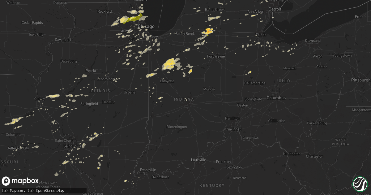
Hail Map in Indiana on September 5, 2014
Get this storm
September 5 map
$229
one time, instant access
Download today. No call, no setup
Keep the $229
Bought the map and want the full workflow? Apply the entire $229 to a subscription within 7 days. None of it is wasted.
Every map, not just this one
This buys you this map. Subscription and you get every map we run, in the markets you choose from a few cities to whole states to nationwide. Plus real-time alerts the moment a storm fires.
Contact data
Name, contact info, occupancy, even credit band for addresses in the footprint. You go from where it hit to who to call.
Become the source they trust
Unlimited branding weather history reports on demand. You already have the documented answer ready for the property owner, and you are the one who showed up with it.
Property data and RoofTrace estimates
Pull up any address you have got, its value and the exact code rules for that jurisdiction, straight from One Click Code. Then RoofTrace estimates the squares, pitch, and roof value, priced the way you price.
Storm reports in Indiana
Indiana
| Date | Description |
|---|---|
| 09/05/20146:24 PM CDT | Reported at angola high school. Hail lasted for 3 minutes. |
| 09/05/20146:24 PM CDT | Reported at angola high school. Hail lasted for 3 minutes. |
| 09/05/20146:15 PM CDT | 2 ft diameter tree down. Took powerlines down with it. |
| 09/05/20145:26 PM CDT | Trees and tree limbs down. No structural damage reported so far. |
| 09/05/20145:20 PM CDT | Public sent picture of measured hail. |
| 09/05/20145:10 PM CDT | Several reports of trees downed in the area. |
| 09/05/20145:08 PM CDT | Trees reported down between 750 and 800 w on old us 30 |
| 09/05/20145:08 PM CDT | Large tree limbs down. |
| 09/05/20145:08 PM CDT | Trees down at 1050 north and 350 east. |
| 09/05/20144:50 PM CDT | A local report indicates 1.00 inch wind near ETNA GREEN |
| 09/05/20144:42 PM CDT | Hail ranged from pea to 1 diameter before rapid change to 1.5 diameter. |
| 09/05/20144:42 PM CDT | Hail ranged from pea to 1 diameter before rapid change to 1.5 diameter. |
| 09/05/20144:40 PM CDT | A local report indicates 1.00 inch wind near BOURBON |
| 09/04/20148:45 PM CDT | Fifteen utility poles down with wires across mobile homes. Winds recorded at 33 mph just south of scene. Time estimated. |
| 09/04/20147:12 PM CDT | 50 to 60 mph wind gusts and several 4 to 5 inch diameter tree limbs down |
All States Impacted by Hail Map on September 5, 2014
Cities Impacted by Hail Map on September 5, 2014
- Wapakoneta, OH
- Beardstown, IL
- Frederick, IL
- Chandlerville, IL
- Virginia, IL
- Fenton, MI
- Linden, MI
- Lake Bluff, IL
- Lake Forest, IL
- Commerce Township, MI
- Fife Lake, MI
- Dixon, MO
- Newellton, LA
- Highland, IL
- Alhambra, IL
- Troy, IL
- Saint Jacob, IL
- Hermann, MO
- Delta, OH
- Hickory, KY
- Boaz, KY
- Herod, IL
- Equality, IL
- Waldo, KS
- Pearl, IL
- Winchester, IL
- Hillview, IL
- Roodhouse, IL
- Holly, MI
- Schell City, MO
- Ypsilanti, MI
- Belleville, MI
- Bad Axe, MI
- Dyer, IN
- Saint John, IN
- Demotte, IN
- Lima, OH
- Harrod, OH
- Waynesfield, OH
- Richards, MO
- Arnold, MO
- Memphis, MI
- Smithboro, IL
- Greenville, IL
- Donnellson, IL
- Pocahontas, IL
- Mulberry Grove, IL
- Timewell, IL
- Howe, IN
- Lagrange, IN
- Elkton, MI
- Rhineland, MO
- Santa Fe, MO
- Perry, MO
- Stoutsville, MO
- Washington, KS
- Linn, KS
- Morrowville, KS
- Quincy, IL
- Blackwell, MO
- De Soto, MO
- Cadet, MO
- Ashley, IL
- Richview, IL
- Grand Rapids, MI
- Monticello, IN
- Buffalo, IN
- Star City, IN
- Winamac, IN
- Hallsville, MO
- Cromwell, IN
- Syracuse, IN
- Ligonier, IN
- Beecher, IL
- Burnettsville, IN
- Wolcott, IN
- Monon, IN
- Reynolds, IN
- Idaville, IN
- Royal Center, IN
- Francesville, IN
- Centralia, MO
- Clark, MO
- Rushville, IL
- Camden, IL
- Waterloo, IL
- Valmeyer, IL
- Arlington Heights, IL
- Palatine, IL
- Bloomingdale, MI
- Gobles, MI
- Snover, MI
- Decker, MI
- New London, MO
- Shipshewana, IN
- Saline, MI
- Le Roy, IL
- Ellsworth, IL
- Downs, IL
- Port Saint Lucie, FL
- Du Quoin, IL
- Hamler, OH
- Holgate, OH
- Crown Point, IN
- Omaha, IL
- Collinsville, IL
- Imperial, MO
- Saint Louis, MO
- Quitman, LA
- Chatham, LA
- Cabery, IL
- Emington, IL
- Kempton, IL
- La Porte, IN
- West Unity, OH
- Osborne, KS
- North Branch, MI
- Western Springs, IL
- Brookfield, IL
- La Grange Park, IL
- Oak Brook, IL
- Lyons, IL
- Hinsdale, IL
- La Grange, IL
- Westchester, IL
- Cullom, IL
- Homer Glen, IL
- Lemont, IL
- Stover, MO
- Fremont, OH
- Helena, OH
- Swartz Creek, MI
- Davison, MI
- Deckerville, MI
- Sandusky, MI
- Nashville, IL
- Malinta, OH
- McClure, OH
- Napoleon, OH
- Grelton, OH
- Augusta, MI
- Sorento, IL
- Union Hill, IL
- Reddick, IL
- Herscher, IL
- Buckingham, IL
- Armstrong, MO
- Higbee, MO
- Fayette, MO
- Red Bud, IL
- Wawaka, IN
- Albion, IN
- Malta, IL
- Dekalb, IL
- Cortland, IL
- Hampshire, IL
- Sycamore, IL
- Maple Park, IL
- Wauconda, IL
- Mundelein, IL
- Grayslake, IL
- Barrington, IL
- Lake Zurich, IL
- Naperville, IL
- Caledonia, MI
- Festus, MO
- Morrison, MO
- Sturgis, KY
- Lake City, MI
- Manton, MI
- Peru, IN
- Bunker Hill, IN
- Miami, IN
- Pleasant Plains, AR
- Hebron, IN
- Wheatfield, IN
- Bonne Terre, MO
- Mineral Point, MO
- Yorkville, IL
- Foley, MO
- Winfield, MO
- Brown City, MI
- Harbor Beach, MI
- Sturgeon, MO
- Paris, MO
- Marine, IL
- Edwardsville, IL
- Port Sanilac, MI
- Carsonville, MI
- South Lyon, MI
- Northville, MI
- Alto, MI
- Lowell, MI
- Fowler, IN
- Medinah, IL
- Roselle, IL
- Itasca, IL
- Elk Grove Village, IL
- Crystal City, MO
- Hillsboro, MO
- Bridgeview, IL
- Justice, IL
- Chicago, IL
- Summit Argo, IL
- Kingston, MI
- Marlette, MI
- Clifford, MI
- Channahon, IL
- Elwood, IL
- Flint, MI
- Bowling Green, OH
- Waterville, OH
- Wewahitchka, FL
- Blountstown, FL
- Mattawan, MI
- Paw Paw, MI
- Kalamazoo, MI
- Clyde, OH
- Glen Ellyn, IL
- Momence, IL
- Grant Park, IL
- Fort Wayne, IN
- Milan, MI
- Norwalk, OH
- Kewanna, IN
- Lenzburg, IL
- Akron, MI
- Burr Oak, MI
- Cuba, IL
- White Pigeon, MI
- Crescent City, IL
- Rankin, IL
- Hoopeston, IL
- Calliham, TX
- Palos Park, IL
- Lombard, IL
- Villa Park, IL
- Elmhurst, IL
- Addison, IL
- Braidwood, IL
- Gardner, IL
- Essex, IL
- Braceville, IL
- Wilmington, IL
- Bunkie, LA
- Washington, LA
- Jay, FL
- Covington, IN
- White Hall, IL
- Lindsey, OH
- Oak Harbor, OH
- Colfax, IL
- Chenoa, IL
- Roscommon, MI
- Orland, IN
- Bronson, MI
- Peck, MI
- Melvin, MI
- Sturgis, MI
- Hobart, IN
- Merrillville, IN
- Madison, MO
- Moberly, MO
- Colon, MI
- Marshall, MI
- Burlington, MI
- Union City, MI
- Sherwood, MI
- Fulton, MI
- Athens, MI
- Vicksburg, MI
- Leonidas, MI
- Mendon, MI
- Tekonsha, MI
- Scotts, MI
- Milford, IL
- Ambia, IN
- Wellington, IL
- Yale, MI
- Imlay City, MI
- Croswell, MI
- Columbiaville, MI
- Lapeer, MI
- Fostoria, OH
- Fair Haven, MI
- Millersburg, IN
- Topeka, IN
- Mangham, LA
- Minden City, MI
- Palms, MI
- Walton, IN
- Burlington, IL
- Saint Charles, IL
- Elgin, IL
- Valparaiso, IN
- Delphi, IN
- Port Huron, MI
- New London, OH
- Brewton, AL
- Wilmette, IL
- Skokie, IL
- Evanston, IL
- Gilberts, IL
- South Elgin, IL
- Algonquin, IL
- Carpentersville, IL
- Huntley, IL
- Dundee, IL
- Sheboygan Falls, WI
- Otterville, MO
- Unionville, MI
- Vermilion, OH
- Logansport, IN
- Mexico, IN
- Denver, IN
- Monterey, IN
- Algonac, MI
- New Bloomfield, MO
- Tebbetts, MO
- Du Bois, IL
- Prairie Du Rocher, IL
- Fults, IL
- Deford, MI
- Clinton, KY
- Holland, MI
- Round Lake, IL
- Bettsville, OH
- Burgoon, OH
- Tiffin, OH
- Kansas, OH
- Osceola, MO
- Tipton, MO
- Fortuna, MO
- East Saint Louis, IL
- Bourbonnais, IL
- Bradley, IL
- Cedar Lake, IN
- Lowell, IN
- Manteno, IL
- Kankakee, IL
- Immokalee, FL
- Marshall, IN
- Crawfordsville, IN
- Keenes, IL
- Reese, MI
- Fairgrove, MI
- Clyde, KS
- Peoria, IL
- Farmington, MI
- West Bloomfield, MI
- Franklin, MI
- Bloomfield Hills, MI
- Alvada, OH
- Clinton, MO
- Monroe City, MO
- Cole Camp, MO
- Rolling Prairie, IN
- Lexington, MI
- Hicksville, OH
- Potosi, MO
- Irondale, MO
- Tippecanoe, IN
- Argos, IN
- Clewiston, FL
- Millstadt, IL
- Greenwell Springs, LA
- Baton Rouge, LA
- Baker, LA
- Port Hope, MI
- Port Austin, MI
- Attica, IN
- Williamsport, IN
- Lebanon, IL
- O'Fallon, IL
- Trenton, IL
- Lake Orion, MI
- Oxford, MI
- Litchfield, MI
- Spencerville, IN
- Saint Joe, IN
- Butler, IN
- Manistee, MI
- Woodville, OH
- Elmore, OH
- Gibsonburg, OH
- Fostoria, MI
- Otter Lake, MI
- Bonfield, IL
- Windsor, MO
- Leesburg, IN
- Warsaw, IN
- Center, MO
- Barnhart, MO
- Bourbon, IN
- Rockville, MO
- Genoa, IL
- Columbus, MI
- Saint Clair, MI
- Ransom, IL
- Kinsman, IL
- Burbank, OK
- Wyoming, MI
- Byron Center, MI
- Grandville, MI
- Mokena, IL
- New Lenox, IL
- Ubly, MI
- Amboy, IN
- Morris, IL
- Manhattan, IL
- Coal City, IL
- Deepwater, MO
- Northbrook, IL
- Deerfield, IL
- Paducah, KY
- Columbus, KS
- Bay Port, MI
- Sebewaing, MI
- Pigeon, MI
- Streamwood, IL
- Mayville, MI
- Ruth, MI
- Arrowsmith, IL
- Clifton, IL
- Lockport, IL
- Romeoville, IL
- Berlin Heights, OH
- Collins, OH
- Wakeman, OH
- Pinckneyville, IL
- Tamaroa, IL
- Agenda, KS
- Concordia, KS
- Meredosia, IL
- Chapin, IL
- Addieville, IL
- Abbeville, LA
- Erath, LA
- Kokomo, IN
- Galveston, IN
- South Whitley, IN
- Huntington, IN
- Steedman, MO
- Mokane, MO
- Fulton, MO
- Riverdale, IL
- Harvey, IL
- Dolton, IL
- Jefferson City, MO
- Sterling Heights, MI
- Clinton Township, MI
- Edwardsburg, MI
- Goshen, IN
- New Paris, IN
- Chicago Heights, IL
- Lansing, IL
- Vermont, IL
- Ipava, IL
- Zion, IL
- Greenville, FL
- Mount Sterling, IL
- Clayton, IL
- Camp Point, IL
- Lewistown, IL
- Labelle, FL
- Winnetka, IL
- New Canton, IL
- Peotone, IL
- Hartsburg, IL
- Toledo, OH
- Holland, OH
- Metamora, MI
- Ponca City, OK
- Potomac, IL
- Petersburg, IL
- Saunemin, IL
- Gaines, MI
- Waukegan, IL
- Hudson, IL
- Normal, IL
- Carlock, IL
- Bloomington, IL
- Monroeville, OH
- Cass City, MI
- Mound Valley, KS
- Altamont, KS
- Amherst, OH
- Eros, LA
- East Chicago, IN
- Hammond, IN
- Saint Marks, FL
- Crawfordville, FL
- Thornton, IL
- Calumet City, IL
- South Holland, IL
- Glenwood, IL
- Junction, IL
- Ramsey, IL
- South Fulton, TN
- Montrose, MO
- Warrenville, IL
- Lisle, IL
- Aurora, IL
- Oswego, IL
- Plainfield, IL
- Sandwich, IL
- Plano, IL
- Somonauk, IL
- Gagetown, MI
- Owendale, MI
- Applegate, MI
- Fort Gratiot, MI
- Angola, IN
- Lowry City, MO
- Seneca, IL
- Verona, IL
- Grand Rapids, OH
- Asbury, MO
- Arenzville, IL
- Indianapolis, IN
- Milton, FL
- Auburn Hills, MI
- Clarkston, MI
- Waterford, MI
- Webberville, MI
- Williamston, MI
- Fowlerville, MI
- Caro, MI
- Silverwood, MI
- Galena, KS
- Joliet, IL
- Crest Hill, IL
- Warsaw, MO
- Troy, MO
- Quincy, MI
- Smithton, MO
- Sedalia, MO
- Mora, MO
- Manchester, MI
- Johnsonville, IL
- Franklin, IL
- Jacksonville, IL
- Ashland, IL
- Tallula, IL
- Grand Blanc, MI
- Pemberville, OH
- Wayne, OH
- Portage, OH
- Eaton Rapids, MI
- Charlotte, MI
- Middlebury, IN
- White Lake, MI
- Davisburg, MI
- Iuka, IL
- Green Valley, IL
- Dwight, IL
- Lucerne, IN
- Wabash, IN
- Converse, IN
- Uniontown, KY
- Waverly, KY
- Frankfort, IL
- Tinley Park, IL
- Henley, MO
- Climax, MI
- Pittsford, MI
- Osseo, MI
- Charleston, MO
- Oswego, KS
- Grand Ridge, IL
- Litchfield, IL
- Beulah, MI
- Plymouth, WI
- Watseka, IL
- Martinton, IL
- Donovan, IL
- South Bend, IN
- Belgrade, MO
- Crestwood, IL
- Alsip, IL
- Hazel Crest, IL
- Markham, IL
- Palos Heights, IL
- Oak Forest, IL
- Midlothian, IL
- Evergreen Park, IL
- Oak Lawn, IL
- Country Club Hills, IL
- Robbins, IL
- Blue Island, IL
- Greenview, IL
- Athens, IL
- Bloomingdale, IN
- Richmond, MI
- Hudsonville, MI
- Clifton, KS
- Greenleaf, KS
- Carleton, MI
- Maybee, MI
- Monroe, MI
- Romeo, MI
- Griffith, IN
- Gary, IN
- Schererville, IN
- Brethren, MI
- Smiths Creek, MI
- Baldwin, IL
- Capac, MI
- Mazon, IL
- Lincoln, MO
- Indiantown, FL
- Chebanse, IL
- Waveland, IN
- Hannibal, MO
- Hillsboro, IN
- Kingman, IN
- Waynetown, IN
- Clarksville, MO
- Eolia, MO
- Ada, MI
- Bardwell, KY
- Wellston, MI
- Canton, IL
- Kenilworth, IL
- Des Plaines, IL
- Niles, IL
- Glenview, IL
- Park Ridge, IL
- Morton Grove, IL
- Golf, IL
- Glencoe, IL
- Annada, MO
- Elsberry, MO
- Winfield, IL
- West Chicago, IL
- Wheaton, IL
- Brookston, IN
- Chalmers, IN
- Mason City, IL
- Laddonia, MO
- Calhoun, MO
- Mayfield, KY
- Marion, KY
- Milford, IN
- Easton, IL
- Griggsville, IL
- Bluffs, IL
- Saybrook, IL
- Anchor, IL
- Hull, IL
- West Lebanon, IN
- Grass Lake, MI
- Springboro, PA
- Albion, PA
- McBain, MI
- Cadillac, MI
- Fairview Heights, IL
- Belleville, IL
- Ochopee, FL
- Hoagland, IN
- Port Gibson, MS
- New Athens, IL
- Bradner, OH
- Remington, IN
- Goodland, IN
- Goodrich, MI
- Pittsburg, KS
- Weir, KS
- Wingo, KY
- Manitou Beach, MI
- Rutland, IL
- Onarga, IL
- Littleton, IL
- Lyons, MI
- Ionia, MI
- Chamois, MO
- Newark, IL
- Sheridan, IL
- Millbrook, IL
- Essexville, MI
- Munger, MI
- Bay City, MI
- Etna Green, IN
- Hoffman Estates, IL
- Murrayville, IL
- Walled Lake, MI
- Holts Summit, MO
- Saint Anne, IL
- Aroma Park, IL
- Paulding, OH
- Oakwood, OH
- Ionia, MO
- Zionsville, IN
- Carmel, IN
- East Carondelet, IL
- Cedar Vale, KS
- Saint Mary, MO
- Sainte Genevieve, MO
- Coatsburg, IL
- Island Lake, IL
- Libertyville, IL
- Vernon Hills, IL
- Cary, IL
- Crystal Lake, IL
- Mchenry, IL
- Willis, MI
- Glasford, IL
- Manito, IL
- Mapleton, IL
- Kingston Mines, IL
- Weston, OH
- Elm Grove, LA
- New Holland, IL
- Minier, IL
- South Boardman, MI
- Houghton Lake, MI
- Cicero, IL
- Berwyn, IL
- Jonesboro, LA
- Payson, IL
- Crocker, MO
- Kilbourne, IL
- Odell, IL
- Cayuga, IN
- Portland, MI
- Eugene, MO
- West Lafayette, IN
- Shawneetown, IL
- Ortonville, MI
- Olivet, MI
- Bellevue, MI
- Ogden, IL
- Saint Joseph, IL
- Wixom, MI
- Novi, MI
- Howell, MI
- Swanton, OH
- Lohman, MO
- Russellville, MO
- Bartlett, IL
- Mount Prospect, IL
- Hanover Park, IL
- Highland Park, IL
- Rolling Meadows, IL
- Schaumburg, IL
- Highwood, IL
- Wheeling, IL
- Prospect Heights, IL


