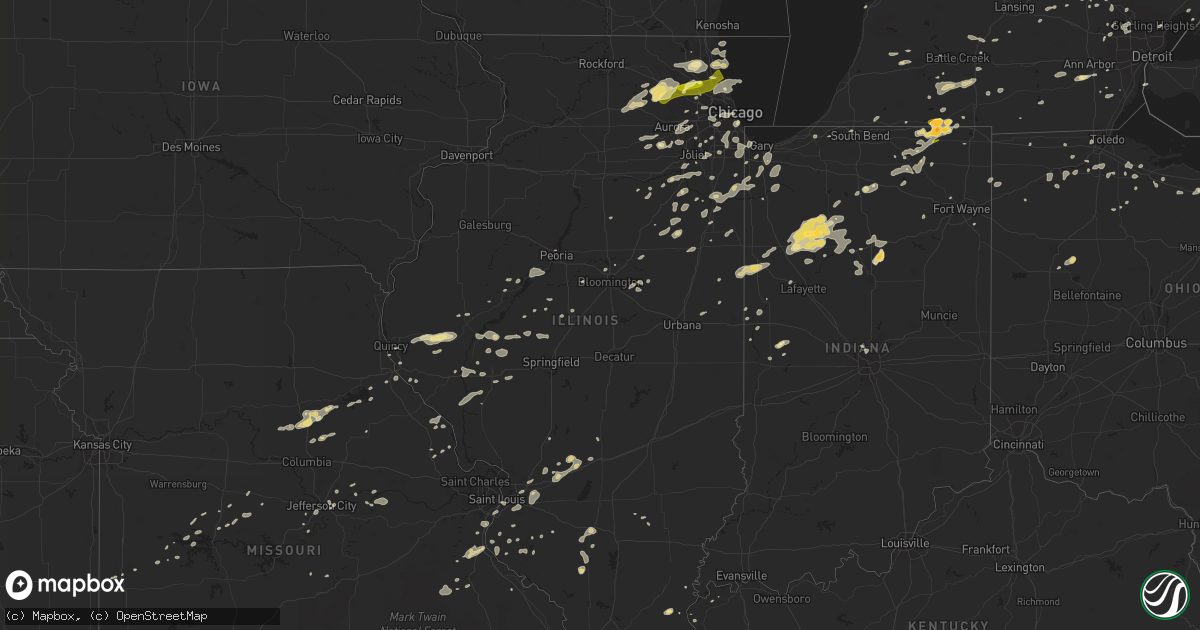
Hail Map in Illinois on September 5, 2014
Get this storm
September 5 map
$229
one time, instant access
Download today. No call, no setup
Keep the $229
Bought the map and want the full workflow? Apply the entire $229 to a subscription within 7 days. None of it is wasted.
Every map, not just this one
This buys you this map. Subscription and you get every map we run, in the markets you choose from a few cities to whole states to nationwide. Plus real-time alerts the moment a storm fires.
Contact data
Name, contact info, occupancy, even credit band for addresses in the footprint. You go from where it hit to who to call.
Become the source they trust
Unlimited branding weather history reports on demand. You already have the documented answer ready for the property owner, and you are the one who showed up with it.
Property data and RoofTrace estimates
Pull up any address you have got, its value and the exact code rules for that jurisdiction, straight from One Click Code. Then RoofTrace estimates the squares, pitch, and roof value, priced the way you price.
Storm reports in Illinois
Illinois
| Date | Description |
|---|---|
| 09/05/20145:50 PM CDT | Elkart fire dept estimated winds. |
| 09/05/20145:33 PM CDT | Power lines down on a house in town. |
| 09/05/20145:30 PM CDT | Tree blown across the winchester/glasgow blacktop. |
| 09/05/20145:25 PM CDT | Large tree limb down south of ill route 123 and 97 junction |
| 09/05/20145:15 PM CDT | Near the cass/menard county line |
| 09/05/20145:10 PM CDT | A local report indicates 70 MPH wind near ASHLAND |
| 09/05/20144:55 PM CDT | Machine shed destroyed |
| 09/05/20144:55 PM CDT | Roof damaged at school. |
| 09/05/20144:45 PM CDT | Large tree limbs blown down. |
| 09/05/20144:44 PM CDT | Large tree limbs down greater than 2 inch diameter. |
| 09/05/20144:42 PM CDT | Trees and powerlines blown down |
| 09/05/20143:00 PM CDT | Light pole and multiple trees and branches down. Received via twitter. |
| 09/05/20142:55 PM CDT | A local report indicates 70 MPH wind near NILES |
| 09/05/20142:55 PM CDT | *** 1 fatal *** media reports a large tree was blown down and according to media reports struck and killed a bicyclist on bike trail. |
| 09/05/20142:55 PM CDT | A local report indicates 63 MPH wind near WHEELING |
| 09/05/20142:55 PM CDT | Near harlem and devon |
| 09/05/20142:55 PM CDT | Tree limbs down 15 to 20 ft in length. Numerous fences down. Est wind gusts to 58 mph. Delayed report. |
| 09/05/20142:55 PM CDT | *** 4 inj *** building under renovation collapsed by winds...4 workers inside trapped had to be rescued and had minor injuries. |
| 09/05/20142:55 PM CDT | Wind gust at oakton community college. |
| 09/05/20142:50 PM CDT | A local report indicates 80 MPH wind near NORTHBROOK |
| 09/05/20142:50 PM CDT | Trees and large branches down blocking street. Near uclid st and camp mcdonald rd. |
| 09/05/20142:50 PM CDT | Corner of palatine rd and webster. Large tree limbs and branches down. Several branches down throughout neighborhood. |
| 09/05/20142:48 PM CDT | Large tree down blocking butterfield road north of il route 176 |
| 09/05/20142:45 PM CDT | Large trees downed. Estimated winds of at least 70 mph. |
| 09/05/20142:45 PM CDT | A wooden frame building under construction was collapsed by thunderstorm winds near the intersection of barrington rd and schaumburg rd. |
| 09/05/20142:45 PM CDT | A local report indicates 71 MPH wind near 3 SE HOFFMAN ESTATES |
| 09/05/20142:44 PM CDT | Est wind gusts 50 to 65 mph along with pea size hail. |
| 09/05/20142:42 PM CDT | Estimated gusts 50 to 60 mph with small tree branches down. |
| 09/05/20142:40 PM CDT | Several periods with gusts of 60+ mph. Large tree branches down. Power outages. |
| 09/05/20142:30 PM CDT | 4 to 6 inch tree limbs down 1 mile west of randall rd south of bogues rd. Also lightning struck house at bowes creek country club. |
| 09/05/20142:30 PM CDT | Medium to large branches down. Near intersection of state st. And s. Elgin blvd. |
| 09/05/20142:25 PM CDT | Numerous trees down. |
| 09/05/20142:00 PM CDT | Est wind gusts 55-60 mph. Also pea size hail. Minor flooding on lincoln hwy. |
| 09/04/20148:30 PM CDT | 5 inch diameter branch blown down. Estimated 60 mph wind gusts. |
| 09/04/20147:44 PM CDT | Tree fell across road block and power went out from thunderstorms. Crews took 3 hours to clean up the tree. |
| 09/04/20147:05 PM CDT | Multiple tree limbs around 3 to 9 inches in diameter downed in the middle of town. One tree limb took a power line down in town. One tree 10 inches in diameter was down |
| 09/04/20147:00 PM CDT | 12 to 15 inch diameter tree branches were blown down on the southeast side of hoopeston. |
All States Impacted by Hail Map on September 5, 2014
Cities Impacted by Hail Map on September 5, 2014
- Wapakoneta, OH
- Beardstown, IL
- Frederick, IL
- Chandlerville, IL
- Virginia, IL
- Fenton, MI
- Linden, MI
- Lake Bluff, IL
- Lake Forest, IL
- Commerce Township, MI
- Fife Lake, MI
- Dixon, MO
- Newellton, LA
- Highland, IL
- Alhambra, IL
- Troy, IL
- Saint Jacob, IL
- Hermann, MO
- Delta, OH
- Hickory, KY
- Boaz, KY
- Herod, IL
- Equality, IL
- Waldo, KS
- Pearl, IL
- Winchester, IL
- Hillview, IL
- Roodhouse, IL
- Holly, MI
- Schell City, MO
- Ypsilanti, MI
- Belleville, MI
- Bad Axe, MI
- Dyer, IN
- Saint John, IN
- Demotte, IN
- Lima, OH
- Harrod, OH
- Waynesfield, OH
- Richards, MO
- Arnold, MO
- Memphis, MI
- Smithboro, IL
- Greenville, IL
- Donnellson, IL
- Pocahontas, IL
- Mulberry Grove, IL
- Timewell, IL
- Howe, IN
- Lagrange, IN
- Elkton, MI
- Rhineland, MO
- Santa Fe, MO
- Perry, MO
- Stoutsville, MO
- Washington, KS
- Linn, KS
- Morrowville, KS
- Quincy, IL
- Blackwell, MO
- De Soto, MO
- Cadet, MO
- Ashley, IL
- Richview, IL
- Grand Rapids, MI
- Monticello, IN
- Buffalo, IN
- Star City, IN
- Winamac, IN
- Hallsville, MO
- Cromwell, IN
- Syracuse, IN
- Ligonier, IN
- Beecher, IL
- Burnettsville, IN
- Wolcott, IN
- Monon, IN
- Reynolds, IN
- Idaville, IN
- Royal Center, IN
- Francesville, IN
- Centralia, MO
- Clark, MO
- Rushville, IL
- Camden, IL
- Waterloo, IL
- Valmeyer, IL
- Arlington Heights, IL
- Palatine, IL
- Bloomingdale, MI
- Gobles, MI
- Snover, MI
- Decker, MI
- New London, MO
- Shipshewana, IN
- Saline, MI
- Le Roy, IL
- Ellsworth, IL
- Downs, IL
- Port Saint Lucie, FL
- Du Quoin, IL
- Hamler, OH
- Holgate, OH
- Crown Point, IN
- Omaha, IL
- Collinsville, IL
- Imperial, MO
- Saint Louis, MO
- Quitman, LA
- Chatham, LA
- Cabery, IL
- Emington, IL
- Kempton, IL
- La Porte, IN
- West Unity, OH
- Osborne, KS
- North Branch, MI
- Western Springs, IL
- Brookfield, IL
- La Grange Park, IL
- Oak Brook, IL
- Lyons, IL
- Hinsdale, IL
- La Grange, IL
- Westchester, IL
- Cullom, IL
- Homer Glen, IL
- Lemont, IL
- Stover, MO
- Fremont, OH
- Helena, OH
- Swartz Creek, MI
- Davison, MI
- Deckerville, MI
- Sandusky, MI
- Nashville, IL
- Malinta, OH
- McClure, OH
- Napoleon, OH
- Grelton, OH
- Augusta, MI
- Sorento, IL
- Union Hill, IL
- Reddick, IL
- Herscher, IL
- Buckingham, IL
- Armstrong, MO
- Higbee, MO
- Fayette, MO
- Red Bud, IL
- Wawaka, IN
- Albion, IN
- Malta, IL
- Dekalb, IL
- Cortland, IL
- Hampshire, IL
- Sycamore, IL
- Maple Park, IL
- Wauconda, IL
- Mundelein, IL
- Grayslake, IL
- Barrington, IL
- Lake Zurich, IL
- Naperville, IL
- Caledonia, MI
- Festus, MO
- Morrison, MO
- Sturgis, KY
- Lake City, MI
- Manton, MI
- Peru, IN
- Bunker Hill, IN
- Miami, IN
- Pleasant Plains, AR
- Hebron, IN
- Wheatfield, IN
- Bonne Terre, MO
- Mineral Point, MO
- Yorkville, IL
- Foley, MO
- Winfield, MO
- Brown City, MI
- Harbor Beach, MI
- Sturgeon, MO
- Paris, MO
- Marine, IL
- Edwardsville, IL
- Port Sanilac, MI
- Carsonville, MI
- South Lyon, MI
- Northville, MI
- Alto, MI
- Lowell, MI
- Fowler, IN
- Medinah, IL
- Roselle, IL
- Itasca, IL
- Elk Grove Village, IL
- Crystal City, MO
- Hillsboro, MO
- Bridgeview, IL
- Justice, IL
- Chicago, IL
- Summit Argo, IL
- Kingston, MI
- Marlette, MI
- Clifford, MI
- Channahon, IL
- Elwood, IL
- Flint, MI
- Bowling Green, OH
- Waterville, OH
- Wewahitchka, FL
- Blountstown, FL
- Mattawan, MI
- Paw Paw, MI
- Kalamazoo, MI
- Clyde, OH
- Glen Ellyn, IL
- Momence, IL
- Grant Park, IL
- Fort Wayne, IN
- Milan, MI
- Norwalk, OH
- Kewanna, IN
- Lenzburg, IL
- Akron, MI
- Burr Oak, MI
- Cuba, IL
- White Pigeon, MI
- Crescent City, IL
- Rankin, IL
- Hoopeston, IL
- Calliham, TX
- Palos Park, IL
- Lombard, IL
- Villa Park, IL
- Elmhurst, IL
- Addison, IL
- Braidwood, IL
- Gardner, IL
- Essex, IL
- Braceville, IL
- Wilmington, IL
- Bunkie, LA
- Washington, LA
- Jay, FL
- Covington, IN
- White Hall, IL
- Lindsey, OH
- Oak Harbor, OH
- Colfax, IL
- Chenoa, IL
- Roscommon, MI
- Orland, IN
- Bronson, MI
- Peck, MI
- Melvin, MI
- Sturgis, MI
- Hobart, IN
- Merrillville, IN
- Madison, MO
- Moberly, MO
- Colon, MI
- Marshall, MI
- Burlington, MI
- Union City, MI
- Sherwood, MI
- Fulton, MI
- Athens, MI
- Vicksburg, MI
- Leonidas, MI
- Mendon, MI
- Tekonsha, MI
- Scotts, MI
- Milford, IL
- Ambia, IN
- Wellington, IL
- Yale, MI
- Imlay City, MI
- Croswell, MI
- Columbiaville, MI
- Lapeer, MI
- Fostoria, OH
- Fair Haven, MI
- Millersburg, IN
- Topeka, IN
- Mangham, LA
- Minden City, MI
- Palms, MI
- Walton, IN
- Burlington, IL
- Saint Charles, IL
- Elgin, IL
- Valparaiso, IN
- Delphi, IN
- Port Huron, MI
- New London, OH
- Brewton, AL
- Wilmette, IL
- Skokie, IL
- Evanston, IL
- Gilberts, IL
- South Elgin, IL
- Algonquin, IL
- Carpentersville, IL
- Huntley, IL
- Dundee, IL
- Sheboygan Falls, WI
- Otterville, MO
- Unionville, MI
- Vermilion, OH
- Logansport, IN
- Mexico, IN
- Denver, IN
- Monterey, IN
- Algonac, MI
- New Bloomfield, MO
- Tebbetts, MO
- Du Bois, IL
- Prairie Du Rocher, IL
- Fults, IL
- Deford, MI
- Clinton, KY
- Holland, MI
- Round Lake, IL
- Bettsville, OH
- Burgoon, OH
- Tiffin, OH
- Kansas, OH
- Osceola, MO
- Tipton, MO
- Fortuna, MO
- East Saint Louis, IL
- Bourbonnais, IL
- Bradley, IL
- Cedar Lake, IN
- Lowell, IN
- Manteno, IL
- Kankakee, IL
- Immokalee, FL
- Marshall, IN
- Crawfordsville, IN
- Keenes, IL
- Reese, MI
- Fairgrove, MI
- Clyde, KS
- Peoria, IL
- Farmington, MI
- West Bloomfield, MI
- Franklin, MI
- Bloomfield Hills, MI
- Alvada, OH
- Clinton, MO
- Monroe City, MO
- Cole Camp, MO
- Rolling Prairie, IN
- Lexington, MI
- Hicksville, OH
- Potosi, MO
- Irondale, MO
- Tippecanoe, IN
- Argos, IN
- Clewiston, FL
- Millstadt, IL
- Greenwell Springs, LA
- Baton Rouge, LA
- Baker, LA
- Port Hope, MI
- Port Austin, MI
- Attica, IN
- Williamsport, IN
- Lebanon, IL
- O'Fallon, IL
- Trenton, IL
- Lake Orion, MI
- Oxford, MI
- Litchfield, MI
- Spencerville, IN
- Saint Joe, IN
- Butler, IN
- Manistee, MI
- Woodville, OH
- Elmore, OH
- Gibsonburg, OH
- Fostoria, MI
- Otter Lake, MI
- Bonfield, IL
- Windsor, MO
- Leesburg, IN
- Warsaw, IN
- Center, MO
- Barnhart, MO
- Bourbon, IN
- Rockville, MO
- Genoa, IL
- Columbus, MI
- Saint Clair, MI
- Ransom, IL
- Kinsman, IL
- Burbank, OK
- Wyoming, MI
- Byron Center, MI
- Grandville, MI
- Mokena, IL
- New Lenox, IL
- Ubly, MI
- Amboy, IN
- Morris, IL
- Manhattan, IL
- Coal City, IL
- Deepwater, MO
- Northbrook, IL
- Deerfield, IL
- Paducah, KY
- Columbus, KS
- Bay Port, MI
- Sebewaing, MI
- Pigeon, MI
- Streamwood, IL
- Mayville, MI
- Ruth, MI
- Arrowsmith, IL
- Clifton, IL
- Lockport, IL
- Romeoville, IL
- Berlin Heights, OH
- Collins, OH
- Wakeman, OH
- Pinckneyville, IL
- Tamaroa, IL
- Agenda, KS
- Concordia, KS
- Meredosia, IL
- Chapin, IL
- Addieville, IL
- Abbeville, LA
- Erath, LA
- Kokomo, IN
- Galveston, IN
- South Whitley, IN
- Huntington, IN
- Steedman, MO
- Mokane, MO
- Fulton, MO
- Riverdale, IL
- Harvey, IL
- Dolton, IL
- Jefferson City, MO
- Sterling Heights, MI
- Clinton Township, MI
- Edwardsburg, MI
- Goshen, IN
- New Paris, IN
- Chicago Heights, IL
- Lansing, IL
- Vermont, IL
- Ipava, IL
- Zion, IL
- Greenville, FL
- Mount Sterling, IL
- Clayton, IL
- Camp Point, IL
- Lewistown, IL
- Labelle, FL
- Winnetka, IL
- New Canton, IL
- Peotone, IL
- Hartsburg, IL
- Toledo, OH
- Holland, OH
- Metamora, MI
- Ponca City, OK
- Potomac, IL
- Petersburg, IL
- Saunemin, IL
- Gaines, MI
- Waukegan, IL
- Hudson, IL
- Normal, IL
- Carlock, IL
- Bloomington, IL
- Monroeville, OH
- Cass City, MI
- Mound Valley, KS
- Altamont, KS
- Amherst, OH
- Eros, LA
- East Chicago, IN
- Hammond, IN
- Saint Marks, FL
- Crawfordville, FL
- Thornton, IL
- Calumet City, IL
- South Holland, IL
- Glenwood, IL
- Junction, IL
- Ramsey, IL
- South Fulton, TN
- Montrose, MO
- Warrenville, IL
- Lisle, IL
- Aurora, IL
- Oswego, IL
- Plainfield, IL
- Sandwich, IL
- Plano, IL
- Somonauk, IL
- Gagetown, MI
- Owendale, MI
- Applegate, MI
- Fort Gratiot, MI
- Angola, IN
- Lowry City, MO
- Seneca, IL
- Verona, IL
- Grand Rapids, OH
- Asbury, MO
- Arenzville, IL
- Indianapolis, IN
- Milton, FL
- Auburn Hills, MI
- Clarkston, MI
- Waterford, MI
- Webberville, MI
- Williamston, MI
- Fowlerville, MI
- Caro, MI
- Silverwood, MI
- Galena, KS
- Joliet, IL
- Crest Hill, IL
- Warsaw, MO
- Troy, MO
- Quincy, MI
- Smithton, MO
- Sedalia, MO
- Mora, MO
- Manchester, MI
- Johnsonville, IL
- Franklin, IL
- Jacksonville, IL
- Ashland, IL
- Tallula, IL
- Grand Blanc, MI
- Pemberville, OH
- Wayne, OH
- Portage, OH
- Eaton Rapids, MI
- Charlotte, MI
- Middlebury, IN
- White Lake, MI
- Davisburg, MI
- Iuka, IL
- Green Valley, IL
- Dwight, IL
- Lucerne, IN
- Wabash, IN
- Converse, IN
- Uniontown, KY
- Waverly, KY
- Frankfort, IL
- Tinley Park, IL
- Henley, MO
- Climax, MI
- Pittsford, MI
- Osseo, MI
- Charleston, MO
- Oswego, KS
- Grand Ridge, IL
- Litchfield, IL
- Beulah, MI
- Plymouth, WI
- Watseka, IL
- Martinton, IL
- Donovan, IL
- South Bend, IN
- Belgrade, MO
- Crestwood, IL
- Alsip, IL
- Hazel Crest, IL
- Markham, IL
- Palos Heights, IL
- Oak Forest, IL
- Midlothian, IL
- Evergreen Park, IL
- Oak Lawn, IL
- Country Club Hills, IL
- Robbins, IL
- Blue Island, IL
- Greenview, IL
- Athens, IL
- Bloomingdale, IN
- Richmond, MI
- Hudsonville, MI
- Clifton, KS
- Greenleaf, KS
- Carleton, MI
- Maybee, MI
- Monroe, MI
- Romeo, MI
- Griffith, IN
- Gary, IN
- Schererville, IN
- Brethren, MI
- Smiths Creek, MI
- Baldwin, IL
- Capac, MI
- Mazon, IL
- Lincoln, MO
- Indiantown, FL
- Chebanse, IL
- Waveland, IN
- Hannibal, MO
- Hillsboro, IN
- Kingman, IN
- Waynetown, IN
- Clarksville, MO
- Eolia, MO
- Ada, MI
- Bardwell, KY
- Wellston, MI
- Canton, IL
- Kenilworth, IL
- Des Plaines, IL
- Niles, IL
- Glenview, IL
- Park Ridge, IL
- Morton Grove, IL
- Golf, IL
- Glencoe, IL
- Annada, MO
- Elsberry, MO
- Winfield, IL
- West Chicago, IL
- Wheaton, IL
- Brookston, IN
- Chalmers, IN
- Mason City, IL
- Laddonia, MO
- Calhoun, MO
- Mayfield, KY
- Marion, KY
- Milford, IN
- Easton, IL
- Griggsville, IL
- Bluffs, IL
- Saybrook, IL
- Anchor, IL
- Hull, IL
- West Lebanon, IN
- Grass Lake, MI
- Springboro, PA
- Albion, PA
- McBain, MI
- Cadillac, MI
- Fairview Heights, IL
- Belleville, IL
- Ochopee, FL
- Hoagland, IN
- Port Gibson, MS
- New Athens, IL
- Bradner, OH
- Remington, IN
- Goodland, IN
- Goodrich, MI
- Pittsburg, KS
- Weir, KS
- Wingo, KY
- Manitou Beach, MI
- Rutland, IL
- Onarga, IL
- Littleton, IL
- Lyons, MI
- Ionia, MI
- Chamois, MO
- Newark, IL
- Sheridan, IL
- Millbrook, IL
- Essexville, MI
- Munger, MI
- Bay City, MI
- Etna Green, IN
- Hoffman Estates, IL
- Murrayville, IL
- Walled Lake, MI
- Holts Summit, MO
- Saint Anne, IL
- Aroma Park, IL
- Paulding, OH
- Oakwood, OH
- Ionia, MO
- Zionsville, IN
- Carmel, IN
- East Carondelet, IL
- Cedar Vale, KS
- Saint Mary, MO
- Sainte Genevieve, MO
- Coatsburg, IL
- Island Lake, IL
- Libertyville, IL
- Vernon Hills, IL
- Cary, IL
- Crystal Lake, IL
- Mchenry, IL
- Willis, MI
- Glasford, IL
- Manito, IL
- Mapleton, IL
- Kingston Mines, IL
- Weston, OH
- Elm Grove, LA
- New Holland, IL
- Minier, IL
- South Boardman, MI
- Houghton Lake, MI
- Cicero, IL
- Berwyn, IL
- Jonesboro, LA
- Payson, IL
- Crocker, MO
- Kilbourne, IL
- Odell, IL
- Cayuga, IN
- Portland, MI
- Eugene, MO
- West Lafayette, IN
- Shawneetown, IL
- Ortonville, MI
- Olivet, MI
- Bellevue, MI
- Ogden, IL
- Saint Joseph, IL
- Wixom, MI
- Novi, MI
- Howell, MI
- Swanton, OH
- Lohman, MO
- Russellville, MO
- Bartlett, IL
- Mount Prospect, IL
- Hanover Park, IL
- Highland Park, IL
- Rolling Meadows, IL
- Schaumburg, IL
- Highwood, IL
- Wheeling, IL
- Prospect Heights, IL


