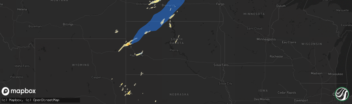
Hail Map in South Dakota on September 4, 2023
The weather event in South Dakota on September 4, 2023 includes Hail and Wind maps. 13 states and 309 cities were impacted and suffered possible damage. The total estimated number of properties impacted is 8,587.
Want more than just the map?
Turn this storm into a full workflow.
- Owner + property data so you know who to knock
- OnDemand branded weather history reports to win the "did we even have hail?" argument
- RoofTrace estimate so reps stop guessing numbers at the door
Bought this map? Upgrade within 7 days and we'll credit the $230. (10-15 min setup call)
Hail
Wind
8,587
Estimated number of impacted properties by a 1.00" hail or larger1,521
Estimated number of impacted properties by a 1.75" hail or larger0
Estimated number of impacted properties by a 2.50" hail or largerStorm reports in South Dakota
South Dakota
| Date | Description |
|---|---|
| 09/04/20236:45 PM CDT | Trees downed... Lost power and resident remains without power an hour after the storm has passed. |
| 09/04/20236:43 PM CDT | A local report indicates 60 MPH wind near 3 W Lemmon |
| 09/04/20236:40 PM CDT | Personal weather station. |
| 09/04/20236:20 PM CDT | Time estimated via radar |
| 09/04/20235:59 PM CDT | A local report indicates 72 MPH wind near 7 SSE Meadow |
| 09/04/20235:55 PM CDT | A local report indicates 69 MPH wind near Bison |
| 09/04/20235:30 PM CDT | A local report indicates 60 MPH wind near 7 SSE Bison |
| 09/04/20235:27 PM CDT | A local report indicates 71 MPH wind near 1 N Buffalo |
| 09/04/20235:08 PM CDT | A local report indicates 63 MPH wind near 1 ENE Mud Butte |
| 09/04/20234:46 PM CDT | A local report indicates 70 MPH wind near 13 NE Newell |
| 09/04/20234:36 PM CDT | A local report indicates 66 MPH wind near 7 WSW Hoover |
| 09/04/20234:32 PM CDT | A local report indicates 70 MPH wind near 14 SSE Hereford |
| 09/04/20234:15 PM CDT | Photo shows several stones of quarter to half dollar size |
| 09/04/20234:15 PM CDT | Winds estimated 60 or higher |
| 09/04/20234:15 PM CDT | Winds estimated 60 or higher |
| 09/04/20234:12 PM CDT | Mping report |
| 09/04/20234:12 PM CDT | Lasted about 10 minutes |
| 09/04/20234:07 PM CDT | A local report indicates 69 MPH wind near Ellsworth AFB |
| 09/04/20233:59 PM CDT | Mping report |
| 09/04/20233:54 PM CDT | Mping report |
| 09/04/20233:52 PM CDT | A local report indicates 1.25 inch wind near Belle Fourche |
| 09/04/20233:52 PM CDT | Time estimated from radar |
| 09/04/20232:54 PM CDT | A local report indicates 59 MPH wind near 8 W Jewel Cave |
| 09/04/20232:44 PM CDT | A local report indicates 63 MPH wind near 8 W Jewel Cave |
| 09/03/20239:28 PM CDT | Several tree branches down. Siding removed from house just over the border in north dakota. |
| 09/03/20239:06 PM CDT | A local report indicates 58 MPH wind near 4 SSE Witten |
| 09/03/20238:55 PM CDT | Mesonet station 13 vivian |
| 09/03/20238:41 PM CDT | A local report indicates 60 MPH wind near 2 E Okreek |
| 09/03/20238:25 PM CDT | A local report indicates 58 MPH wind near 7 ESE Rosebud |
| 09/03/20237:36 PM CDT | A local report indicates 58 MPH wind near 7 E Wanblee |
All States Impacted by Hail Map on September 4, 2023
Cities Impacted by Hail Map on September 4, 2023
- Bluffton, AR
- Clarksville, AR
- Lamar, AR
- Belleville, AR
- Dardanelle, AR
- Havana, AR
- Hagarville, AR
- Delaware, AR
- New Blaine, AR
- Scranton, AR
- London, AR
- Belle Fourche, SD
- Aladdin, WY
- Beulah, WY
- Saint Onge, SD
- Rapid City, SD
- Box Elder, SD
- Ellsworth Afb, SD
- Mitchell, NE
- Newell, SD
- Nisland, SD
- Mud Butte, SD
- Reva, SD
- Buffalo, SD
- Prairie City, SD
- Bison, SD
- New Underwood, SD
- Dover, AR
- Calico Rock, AR
- Morrill, NE
- Whitewood, SD
- Doniphan, MO
- Paris, AR
- Knobel, AR
- Fort Laramie, WY
- Hazen, AR
- Willow Springs, MO
- West Plains, MO
- Verona, MO
- Cassville, MO
- Purdy, MO
- Corning, AR
- Success, AR
- Lesterville, MO
- Quitman, AR
- Livingston, TX
- Quitman, LA
- Stuttgart, AR
- Annapolis, MO
- Ironton, MO
- Lingle, WY
- Torrington, WY
- Shirley, AR
- Ruston, LA
- Fox, AR
- Clinton, AR
- Mountain Home, AR
- Ozone, AR
- Mount Judea, AR
- Pelsor, AR
- Jay Em, WY
- Eminence, MO
- Sundance, WY
- Coushatta, LA
- Ringgold, LA
- McGee, MO
- Black Hawk, SD
- Humphrey, AR
- Gainesville, MO
- Clarkridge, AR
- Batesville, AR
- Douglas, WY
- Elizabeth, AR
- Viola, AR
- Chadron, NE
- Pine Ridge, SD
- Russellville, AR
- Grandin, MO
- Ellsinore, MO
- Campbell, MO
- Qulin, MO
- Moorcroft, WY
- Imboden, AR
- Cherokee Village, AR
- Mammoth Spring, AR
- Hardy, AR
- Aurora, MO
- Van Buren, MO
- Williamsville, MO
- Branson, MO
- Fairfield Bay, AR
- Atkins, AR
- Magazine, AR
- Ellington, MO
- Gassville, AR
- Bixby, MO
- Yoder, WY
- Cave City, AR
- Lyman, NE
- Hawk Springs, WY
- Elk Creek, MO
- Cabool, MO
- Solo, MO
- Houston, MO
- Yellville, AR
- Marvell, AR
- Shawnee, WY
- Flippin, AR
- Broseley, MO
- Meadow, SD
- Jerusalem, AR
- Scotland, AR
- Livermore, CO
- Peach Orchard, AR
- Cloutierville, LA
- Cotter, AR
- Upton, WY
- Salem, AR
- Leslie, AR
- Lodgepole, SD
- Lemmon, SD
- Dupree, SD
- Keldron, SD
- Hettinger, ND
- McIntosh, SD
- Selfridge, ND
- Morristown, SD
- Watauga, SD
- New Leipzig, ND
- McLaughlin, SD
- Hebron, ND
- Richardton, ND
- Glen Ullin, ND
- Beulah, ND
- New Salem, ND
- Hazen, ND
- Stanton, ND
- Elgin, ND
- Carson, ND
- Shields, ND
- Raleigh, ND
- Flasher, ND
- Walker, SD
- Solen, ND
- Fort Yates, ND
- Center, ND
- Saint Anthony, ND
- Mandan, ND
- Bismarck, ND
- Cannon Ball, ND
- Baldwin, ND
- Hazelton, ND
- Linton, ND
- Sterling, ND
- Braddock, ND
- Dawson, ND
- Steele, ND
- Menoken, ND
- Driscoll, ND
- Moffit, ND
- Wilton, ND
- Washburn, ND
- Tappen, ND
- Regan, ND
- Tuttle, ND
- Robinson, ND
- Wing, ND
- Pettibone, ND
- Hurdsfield, ND
- Goodrich, ND
- Chaseley, ND
- Bowdon, ND
- Harvey, ND
- Woodworth, ND
- Fessenden, ND
- Sykeston, ND
- Cathay, ND
- Carrington, ND
- New Rockford, ND
- Oberon, ND
- Sheyenne, ND
- Warwick, ND
- Mchenry, ND
- Leachville, AR
- Arbyrd, MO
- Chappell, NE
- Big Springs, NE
- Bridgeport, NE
- Searcy, AR
- Griffithville, AR
- Etowah, AR
- Osceola, AR
- Hammond, MT
- Boyes, MT
- Lefor, ND
- Lemoyne, NE
- Arthur, NE
- Scottsbluff, NE
- Gering, NE
- Marsland, NE
- Hemingford, NE
- Harrison, NE
- Delhi, LA
- Rockaway Beach, MO
- Broadus, MT
- Carlisle, AR
- Alzada, MT
- Cleveland, AR
- Augusta, AR
- Mott, ND
- Paragould, AR
- Faith, SD
- Dell, AR
- Manila, AR
- Rolla, MO
- Vichy, MO
- Mount Vernon, AR
- Idaho Falls, ID
- Weiner, AR
- Fisher, AR
- Glenwood, AR
- Gipsy, MO
- Zalma, MO
- McCrory, AR
- Camp Crook, SD
- Ward, AR
- Saint Michael, ND
- Fort Totten, ND
- Devils Lake, ND
- Tolna, ND
- Crary, ND
- Lakota, ND
- Pekin, ND
- Lawton, ND
- Webster, ND
- Sharon, ND
- Aneta, ND
- Northwood, ND
- Reynolds, ND
- East Grand Forks, MN
- Grand Forks, ND
- Thompson, ND
- Hatton, ND
- Emerado, ND
- Fisher, MN
- Larimore, ND
- Arvilla, ND
- Grand Forks Afb, ND
- Crookston, MN
- Euclid, MN
- Warren, MN
- Petersburg, ND
- Michigan, ND
- Fordville, ND
- Brocket, ND
- Lankin, ND
- Edinburg, ND
- Park River, ND
- Edmore, ND
- Crystal, ND
- Mountain, ND
- Osnabrock, ND
- Adams, ND
- Fairdale, ND
- Cavalier, ND
- Hensel, ND
- Milton, ND
- Glasston, ND
- Hoople, ND
- Pisek, ND
- Hamilton, ND
- Saint Thomas, ND
- Bathgate, ND
- Pembina, ND
- Drayton, ND
- Mekinock, ND
- Manvel, ND
- Alvarado, MN
- Argyle, MN
- Viking, MN
- Stephen, MN
- Newfolden, MN
- Strandquist, MN
- Karlstad, MN
- Greenbush, MN
- Strathcona, MN
- Middle River, MN
- Roseau, MN
- Agar, SD
- Onida, SD
- Gettysburg, SD
- Badger, MN
- Mcville, ND
- Kensal, ND
- Atwood, KS
- Wakpala, SD
- Salol, MN
- Wannaska, MN
- Ovid, CO
- Julesburg, CO
- Hannaford, ND
- McCook, NE
- Luverne, ND
- Warroad, MN
- Roosevelt, MN
- Hanover, KS
- Valley City, ND
- Hope, ND
- Clifford, ND


