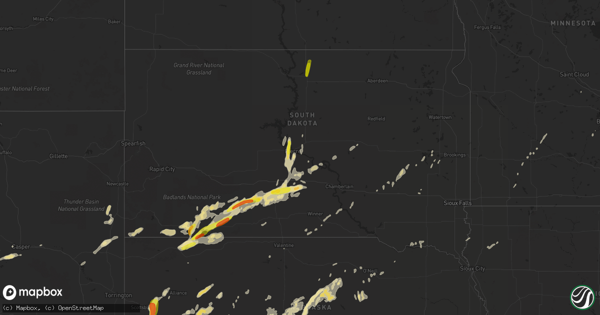
Hail Map in South Dakota on September 4, 2016
Get this storm
September 4 map
$229
one time, instant access
Download today. No call, no setup
Keep the $229
Bought the map and want the full workflow? Apply the entire $229 to a subscription within 7 days. None of it is wasted.
Every map, not just this one
This buys you this map. Subscription and you get every map we run, in the markets you choose from a few cities to whole states to nationwide. Plus real-time alerts the moment a storm fires.
Contact data
Name, contact info, occupancy, even credit band for addresses in the footprint. You go from where it hit to who to call.
Become the source they trust
Unlimited branding weather history reports on demand. You already have the documented answer ready for the property owner, and you are the one who showed up with it.
Property data and RoofTrace estimates
Pull up any address you have got, its value and the exact code rules for that jurisdiction, straight from One Click Code. Then RoofTrace estimates the squares, pitch, and roof value, priced the way you price.
Storm reports in South Dakota
South Dakota
| Date | Description |
|---|---|
| 09/04/20166:55 PM CDT | . |
| 09/04/20166:31 PM CDT | . |
| 09/04/20166:10 PM CDT | A local report indicates 60 MPH wind near 4 WNW SLIM BUTTE |
| 09/04/20166:01 PM CDT | Hail of various sizes including quarter sized. |
| 09/04/20165:55 PM CDT | A local report indicates 60 MPH wind near 10 NNW WHITE RIVER |
| 09/04/20165:28 PM CDT | A local report indicates 60 MPH wind near 2 NNE CEDAR BUTTE |
| 09/04/20164:45 PM CDT | A local report indicates 60 MPH wind near 3 SSE ALLEN |
| 09/04/20164:24 PM CDT | A local report indicates 1.00 inch wind near 4 SSW WANBLEE |
| 09/04/20163:45 PM CDT | Lasted 10 to 15 minutes |
| 09/04/201612:51 AM CDT | Widespread tree damage. Time estimated based on radar. |
| 09/04/201612:45 AM CDT | . |
| 09/04/201612:15 AM CDT | Trees down and some property damage. Extent of damage unknown at this time. Report time based on radar. |
| 09/04/201612:11 AM CDT | Couple of 6 inch diameter tree limbs down. |
| 09/03/20169:43 PM CDT | 2 inch diameter tree branches snapped from thunderstorm winds |
| 09/03/20168:50 PM CDT | A local report indicates 58 MPH wind near 1 NE MIDLAND |
| 09/03/20168:15 PM CDT | Mesonet station saint lawrence 1 wnw /kmka/. |
| 09/03/20167:58 PM CDT | A local report indicates 58 MPH wind near 11 SW PARMELEE |
| 09/03/20167:58 PM CDT | A local report indicates 67 MPH wind near 7 E WANBLEE |
| 09/03/20167:56 PM CDT | . |
| 09/03/20167:40 PM CDT | A local report indicates 60 MPH wind near 5 ENE MARTIN |
| 09/03/20167:01 PM CDT | A local report indicates 60 MPH wind near 7 SSW BATESLAND |
All States Impacted by Hail Map on September 4, 2016
Cities Impacted by Hail Map on September 4, 2016
- Alcova, WY
- Jeffrey City, WY
- Remsen, IA
- Le Mars, IA
- Sterling, CO
- Snyder, CO
- Atwood, CO
- Merino, CO
- Purdum, NE
- Halsey, NE
- Stapleton, NE
- Tryon, NE
- Casper, WY
- Baldwin, ND
- Fort Morgan, CO
- Log Lane Village, CO
- Ashby, NE
- Whitman, NE
- Bayard, NE
- Mcclusky, ND
- Denhoff, ND
- Anamoose, ND
- Arlington, SD
- Wanblee, SD
- Long Valley, SD
- Holly, CO
- Sheridan Lake, CO
- Texico, NM
- Friona, TX
- Cavalier, ND
- Dubois, ID
- Pine Ridge, SD
- Rushville, NE
- Oakley, KS
- Winona, KS
- Scott City, KS
- Chambers, NE
- Lusk, WY
- Dunning, NE
- Presho, SD
- White River, SD
- Murdo, SD
- Vivian, SD
- Draper, SD
- Wood, SD
- Rock Springs, WY
- Bairoil, WY
- Hay Springs, NE
- Batesland, SD
- Dalhart, TX
- Julesburg, CO
- Arthur, NE
- Amherst, CO
- Lemoyne, NE
- Champion, NE
- Big Springs, NE
- Idalia, CO
- Venango, NE
- Haigler, NE
- Holyoke, CO
- Wray, CO
- Burlington, CO
- Brule, NE
- Lewellen, NE
- Sharon Springs, KS
- Monument, KS
- Wallace, KS
- Tribune, KS
- Leoti, KS
- Grinnell, KS
- Lamar, CO
- Tabor, SD
- Atkinson, NE
- Buchanan, ND
- Cleveland, ND
- Martin, SD
- Bridgeport, NE
- Harrold, SD
- Kimball, NE
- Dix, NE
- Chadron, NE
- Wounded Knee, SD
- Harrisburg, NE
- Pingree, ND
- Jamestown, ND
- Lakeside, NE
- Ellsworth, NE
- Brewster, NE
- Arnold, NE
- Fort Pierre, SD
- Oelrichs, SD
- Broadwater, NE
- Mcgrew, NE
- Alliance, NE
- Gering, NE
- Minatare, NE
- Picacho, NM
- Artesian, SD
- Letcher, SD
- Lance Creek, WY
- Center, ND
- Wilton, ND
- Kyle, SD
- Manderson, SD
- Porcupine, SD
- Devils Lake, ND
- Crary, ND
- Pierre, SD
- Bingham, NE
- Norris, SD
- Allen, SD
- Akron, CO
- Hillrose, CO
- Otis, CO
- Brush, CO
- Bassett, NE
- Stephan, SD
- Highmore, SD
- Long Pine, NE
- Morgan, MN
- Clements, MN
- Cheyenne Wells, CO
- Sutherland, NE
- Paxton, NE
- Platteville, CO
- Mead, CO
- Longmont, CO
- Taylor, NE
- Edmore, ND
- Lawton, ND
- Lisco, NE
- Colby, KS
- Fedora, SD
- Carthage, SD
- Glendo, WY
- Forest Lake, MN
- Lake Placid, FL
- Mountain City, NV
- Maple Lake, MN
- Herndon, KS
- Oberlin, KS
- Oglala, SD
- Amelia, NE
- Burwell, NE
- Crofton, NE
- Yankton, SD
- Iowa, LA
- Valentine, NE
- Miller, SD
- Platte, SD
- Stuart, NE
- Weldona, CO
- Mandan, ND
- New Salem, ND
- Fleming, CO
- Norton, KS
- Hyannis, NE
- Colome, SD
- Dallas, SD
- Spencer, SD
- Glenfield, ND
- Carrington, ND
- Kensal, ND
- Oldham, SD
- De Smet, SD
- Martin, ND
- Lower Brule, SD
- Seneca, NE
- Manville, WY
- Mchenry, ND
- New Rockford, ND
- Shawnee, WY
- Lamberton, MN
- Zolfo Springs, FL
- Arcadia, FL
- Haxtun, CO
- Goodland, KS
- Edson, KS
- Daniel, WY
- Oshkosh, NE
- Sebring, FL
- Fairdale, ND
- Hawarden, IA
- Alcester, SD
- Atwood, KS
- Page, NE
- Oral, SD
- Kennebec, SD
- Lake Preston, SD
- Fulda, MN
- Saint Lawrence, SD
- Carver, MN
- Bushnell, NE
- Bismarck, ND
- Plankinton, SD
- Sanborn, MN
- Greeley, CO
- Evans, CO
- Glenrock, WY
- Gordon, NE
- Edgemont, SD
- Thedford, NE
- Inman, NE
- Oneill, NE
- Ainsworth, NE
- Saint Francis, KS
- Paoli, CO
- Milton, ND
- Lodgepole, NE
- Belle Plaine, MN
- Kimball, SD
- Buna, TX
- Springfield, MN
- Merriman, NE
- Onida, SD
- Ramona, SD
- Mullen, NE
- Rawlins, WY
- Springfield, SD
- Saint Francis, SD
- Wabasso, MN
- Langdon, ND
- Osnabrock, ND
- Mountain, ND
- Walhalla, ND
- Wiggins, CO
- Harvey, ND
- Winner, SD
- Verdigre, NE
- Lakota, ND
- Marcus, IA
- Granville, IA
- Westbrook, MN
- Keystone, NE
- Webster, ND
- Shakopee, MN
- Burke, SD
- Mitchell, SD
- Fairfax, MN
- Franklin, MN
- Kit Carson, CO
- Gove, KS
- Grainfield, KS
- Java, SD
- Herreid, SD
- Selby, SD
- Mound City, SD
- Potter, NE


