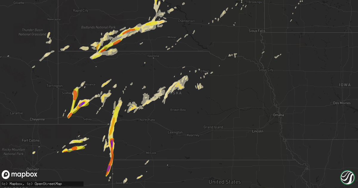
Hail Map in Nebraska on September 4, 2016
Get this storm
September 4 map
$229
one time, instant access
Download today. No call, no setup
Keep the $229
Bought the map and want the full workflow? Apply the entire $229 to a subscription within 7 days. None of it is wasted.
Every map, not just this one
This buys you this map. Subscription and you get every map we run, in the markets you choose from a few cities to whole states to nationwide. Plus real-time alerts the moment a storm fires.
Contact data
Name, contact info, occupancy, even credit band for addresses in the footprint. You go from where it hit to who to call.
Become the source they trust
Unlimited branding weather history reports on demand. You already have the documented answer ready for the property owner, and you are the one who showed up with it.
Property data and RoofTrace estimates
Pull up any address you have got, its value and the exact code rules for that jurisdiction, straight from One Click Code. Then RoofTrace estimates the squares, pitch, and roof value, priced the way you price.
Storm reports in Nebraska
Nebraska
| Date | Description |
|---|---|
| 09/04/20166:31 PM CDT | A local report indicates 1.00 inch wind near 14 N RUSHVILLE |
| 09/04/20166:25 PM CDT | In addition to hail...winds were estimated at 30-40 mph |
| 09/04/20166:25 PM CDT | Est 60 mph winds with large hail possibly to quarter size. Over one inch of rain with water covering the road |
| 09/04/20166:22 PM CDT | King canyon raws |
| 09/04/20166:16 PM CDT | In addition to hail...winds were estimated at 30-40 mph |
| 09/04/20166:15 PM CDT | A local report indicates 1.00 inch wind near 13 ENE TRYON |
| 09/04/20166:15 PM CDT | Mesonet observation from near big springs...up938 at 515 pm mdt. |
| 09/04/20166:15 PM CDT | Hail to quarter size with an occasional golf ball. Wind speed est 60 mph |
| 09/04/20166:00 PM CDT | A local report indicates 3.00 inch wind near 6 SW BRIDGEPORT |
| 09/04/20166:00 PM CDT | A local report indicates 3.00 inch wind near 6 SE BRIDGEPORT |
| 09/04/20165:57 PM CDT | A local report indicates 1.00 inch wind near 3 SSW BROADWATER |
| 09/04/20165:57 PM CDT | A local report indicates 1.00 inch wind near 3 SSW BRIDGEPORT |
| 09/04/20164:55 PM CDT | A local report indicates 2.50 inch wind near 6 SSW BRIDGEPORT |
| 09/04/20164:52 PM CDT | 2 to 3 inch diameter hail reported. |
| 09/04/20164:50 PM CDT | A local report indicates 1.00 inch wind near 3 SW MCGREW |
| 09/04/20164:45 PM CDT | Golfball hail reported at intersection of hwy 44 and hwy 49. |
| 09/04/20164:45 PM CDT | Report relayed by kneb radio. |
| 09/04/20164:41 PM CDT | A local report indicates 1.75 inch wind near KIMBALL |
| 09/04/20164:28 PM CDT | Ef0 landspout tornado touched down in open country and was in contact with the ground for less than five minutes before dissipating. |
| 09/03/20169:20 PM CDT | 50 mph winds also reported |
| 09/03/20169:13 PM CDT | A local report indicates 1.25 inch wind near 7 NW STAPLETON |
| 09/03/20169:12 PM CDT | Brief tornado 10 miles north northwest of stapleton. Reported by storm chasers located approximately 2 miles north of stapleton on highway 83 looking west. |
| 09/03/20168:45 PM CDT | Trees bending over from the wind. Pea size hail also reported |
| 09/03/20167:35 PM CDT | Trees bending over with small limbs broken off |
| 09/03/20167:00 PM CDT | A local report indicates 60 MPH wind near 6 NNW ARTHUR |
All States Impacted by Hail Map on September 4, 2016
Cities Impacted by Hail Map on September 4, 2016
- Alcova, WY
- Jeffrey City, WY
- Remsen, IA
- Le Mars, IA
- Sterling, CO
- Snyder, CO
- Atwood, CO
- Merino, CO
- Purdum, NE
- Halsey, NE
- Stapleton, NE
- Tryon, NE
- Casper, WY
- Baldwin, ND
- Fort Morgan, CO
- Log Lane Village, CO
- Ashby, NE
- Whitman, NE
- Bayard, NE
- Mcclusky, ND
- Denhoff, ND
- Anamoose, ND
- Arlington, SD
- Wanblee, SD
- Long Valley, SD
- Holly, CO
- Sheridan Lake, CO
- Texico, NM
- Friona, TX
- Cavalier, ND
- Dubois, ID
- Pine Ridge, SD
- Rushville, NE
- Oakley, KS
- Winona, KS
- Scott City, KS
- Chambers, NE
- Lusk, WY
- Dunning, NE
- Presho, SD
- White River, SD
- Murdo, SD
- Vivian, SD
- Draper, SD
- Wood, SD
- Rock Springs, WY
- Bairoil, WY
- Hay Springs, NE
- Batesland, SD
- Dalhart, TX
- Julesburg, CO
- Arthur, NE
- Amherst, CO
- Lemoyne, NE
- Champion, NE
- Big Springs, NE
- Idalia, CO
- Venango, NE
- Haigler, NE
- Holyoke, CO
- Wray, CO
- Burlington, CO
- Brule, NE
- Lewellen, NE
- Sharon Springs, KS
- Monument, KS
- Wallace, KS
- Tribune, KS
- Leoti, KS
- Grinnell, KS
- Lamar, CO
- Tabor, SD
- Atkinson, NE
- Buchanan, ND
- Cleveland, ND
- Martin, SD
- Bridgeport, NE
- Harrold, SD
- Kimball, NE
- Dix, NE
- Chadron, NE
- Wounded Knee, SD
- Harrisburg, NE
- Pingree, ND
- Jamestown, ND
- Lakeside, NE
- Ellsworth, NE
- Brewster, NE
- Arnold, NE
- Fort Pierre, SD
- Oelrichs, SD
- Broadwater, NE
- Mcgrew, NE
- Alliance, NE
- Gering, NE
- Minatare, NE
- Picacho, NM
- Artesian, SD
- Letcher, SD
- Lance Creek, WY
- Center, ND
- Wilton, ND
- Kyle, SD
- Manderson, SD
- Porcupine, SD
- Devils Lake, ND
- Crary, ND
- Pierre, SD
- Bingham, NE
- Norris, SD
- Allen, SD
- Akron, CO
- Hillrose, CO
- Otis, CO
- Brush, CO
- Bassett, NE
- Stephan, SD
- Highmore, SD
- Long Pine, NE
- Morgan, MN
- Clements, MN
- Cheyenne Wells, CO
- Sutherland, NE
- Paxton, NE
- Platteville, CO
- Mead, CO
- Longmont, CO
- Taylor, NE
- Edmore, ND
- Lawton, ND
- Lisco, NE
- Colby, KS
- Fedora, SD
- Carthage, SD
- Glendo, WY
- Forest Lake, MN
- Lake Placid, FL
- Mountain City, NV
- Maple Lake, MN
- Herndon, KS
- Oberlin, KS
- Oglala, SD
- Amelia, NE
- Burwell, NE
- Crofton, NE
- Yankton, SD
- Iowa, LA
- Valentine, NE
- Miller, SD
- Platte, SD
- Stuart, NE
- Weldona, CO
- Mandan, ND
- New Salem, ND
- Fleming, CO
- Norton, KS
- Hyannis, NE
- Colome, SD
- Dallas, SD
- Spencer, SD
- Glenfield, ND
- Carrington, ND
- Kensal, ND
- Oldham, SD
- De Smet, SD
- Martin, ND
- Lower Brule, SD
- Seneca, NE
- Manville, WY
- Mchenry, ND
- New Rockford, ND
- Shawnee, WY
- Lamberton, MN
- Zolfo Springs, FL
- Arcadia, FL
- Haxtun, CO
- Goodland, KS
- Edson, KS
- Daniel, WY
- Oshkosh, NE
- Sebring, FL
- Fairdale, ND
- Hawarden, IA
- Alcester, SD
- Atwood, KS
- Page, NE
- Oral, SD
- Kennebec, SD
- Lake Preston, SD
- Fulda, MN
- Saint Lawrence, SD
- Carver, MN
- Bushnell, NE
- Bismarck, ND
- Plankinton, SD
- Sanborn, MN
- Greeley, CO
- Evans, CO
- Glenrock, WY
- Gordon, NE
- Edgemont, SD
- Thedford, NE
- Inman, NE
- Oneill, NE
- Ainsworth, NE
- Saint Francis, KS
- Paoli, CO
- Milton, ND
- Lodgepole, NE
- Belle Plaine, MN
- Kimball, SD
- Buna, TX
- Springfield, MN
- Merriman, NE
- Onida, SD
- Ramona, SD
- Mullen, NE
- Rawlins, WY
- Springfield, SD
- Saint Francis, SD
- Wabasso, MN
- Langdon, ND
- Osnabrock, ND
- Mountain, ND
- Walhalla, ND
- Wiggins, CO
- Harvey, ND
- Winner, SD
- Verdigre, NE
- Lakota, ND
- Marcus, IA
- Granville, IA
- Westbrook, MN
- Keystone, NE
- Webster, ND
- Shakopee, MN
- Burke, SD
- Mitchell, SD
- Fairfax, MN
- Franklin, MN
- Kit Carson, CO
- Gove, KS
- Grainfield, KS
- Java, SD
- Herreid, SD
- Selby, SD
- Mound City, SD
- Potter, NE


