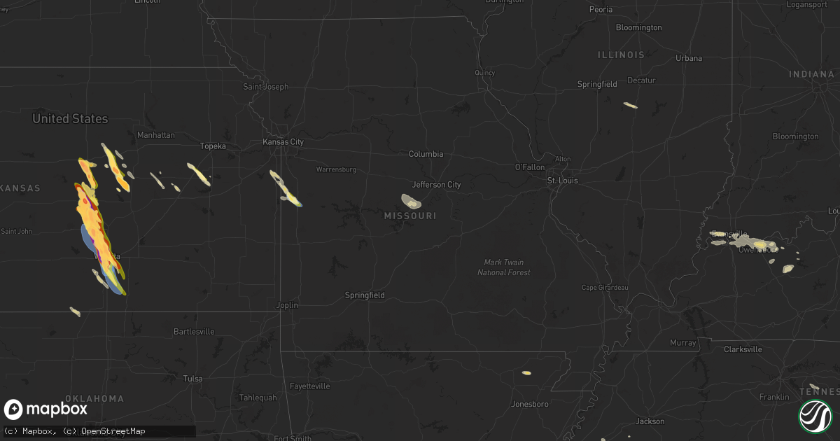
Hail Map in Missouri on September 3, 2025
Get this storm
September 3 map
$229
one time, instant access
Download today. No call, no setup
Keep the $229
Bought the map and want the full workflow? Apply the entire $229 to a subscription within 7 days. None of it is wasted.
Every map, not just this one
This buys you this map. Subscription and you get every map we run, in the markets you choose from a few cities to whole states to nationwide. Plus real-time alerts the moment a storm fires.
Contact data
Name, contact info, occupancy, even credit band for addresses in the footprint. You go from where it hit to who to call.
Become the source they trust
Unlimited branding weather history reports on demand. You already have the documented answer ready for the property owner, and you are the one who showed up with it.
Property data and RoofTrace estimates
Pull up any address you have got, its value and the exact code rules for that jurisdiction, straight from One Click Code. Then RoofTrace estimates the squares, pitch, and roof value, priced the way you price.
Storm reports in Missouri
Missouri
| Date | Description |
|---|---|
| 09/02/202510:26 PM CDT | Several reports of downed tree limbs and wires between passaic and ballard. Time estimated from radar. |
| 09/02/202510:18 PM CDT | A local report indicates 1.00 inch wind near 2 S Adrian |
| 09/02/202510:18 PM CDT | A local report indicates 70 MPH wind near 2 N Passaic |
| 09/02/202510:15 PM CDT | Several downed trees reported near skyline drive. Time estimated from radar. |
| 09/02/202510:10 PM CDT | At least 15 broken power poles near the crescent hill substation in bates county in northern bates county. Time estimated from radar. |
| 09/02/202510:08 PM CDT | Downed trees at a residence near route 18 and route ff. Hail also stripped paint from a house and damaged shingles. Time estimated from radar. |
| 09/02/202510:06 PM CDT | Windows broken out of a home by 1 inch plus hail. |
| 09/02/202510:05 PM CDT | Campers overturned... Trees and powerlines down... And property damage northwest of adrian. Time estimated from radar. Reported via social media. |
| 09/02/202510:03 PM CDT | Trees and powerlines down making road impassible. |
| 09/02/202510:02 PM CDT | Flagpole snapped... Several trees and limbs downed... And minor property damage at a residence on cr 15272. Time estimated from radar. |
| 09/02/202510:00 PM CDT | Trees and powerlines down. |
| 09/02/20259:57 PM CDT | Multiple trees and powerlines down north of route aa. Time estimated from radar. |
| 09/02/20258:21 PM CDT | Emergency manager reports power outages due to strong wind gusts. |
| 09/02/20258:17 PM CDT | Several trees down and property damage at a business near cr 11004. Time estimated from radar. |
| 09/02/20258:15 PM CDT | Structures damaged from thunderstorm. Delayed report. |
| 09/02/20258:12 PM CDT | Several downed trees and limbs near harlequin drive. Time estimated from radar. |
| 09/02/20258:10 PM CDT | Social media report of quarter size hail and tree and vehicle damage from strong winds on 7th street. Time estimated from radar. |
| 09/02/20258:09 PM CDT | Downed trees and limbs along 8th street. Time estimated from radar. |
All States Impacted by Hail Map on September 3, 2025
Cities Impacted by Hail Map on September 3, 2025
- Linden, IA
- Jamaica, IA
- Yale, IA
- Chalmers, IN
- Wolcott, IN
- Minneola, KS
- Whiteville, TN
- Burkesville, KY
- Macon, MS
- Shuqualak, MS
- Red Boiling Springs, TN
- Moss, TN
- Whitleyville, TN
- Scooba, MS
- Ethelsville, AL
- Millport, AL
- Epes, AL
- Walnut, MS
- Emelle, AL
- Salina, KS
- Cruger, MS
- Lindsborg, KS
- Abilene, KS
- Solomon, KS
- Lexington, MS
- Harveyville, KS
- Eskridge, KS
- Plains, KS
- Hope, KS
- Assaria, KS
- Mason, TN
- Enterprise, KS
- Burlingame, KS
- Delaplaine, AR
- Peach Orchard, AR
- Marquette, KS
- Biggers, AR
- Reading, KS
- New Cambria, KS
- Gypsum, KS
- Ramona, KS
- Lost Springs, KS
- Tampa, KS
- Mcpherson, KS
- Osage City, KS
- Chapman, KS
- Meade, KS
- Galva, KS
- Falun, KS
- Lincolnville, KS
- Herington, KS
- Lyndon, KS
- Lebanon, TN
- Durham, KS
- Moundridge, KS
- Lebo, KS
- Canton, KS
- Inman, KS
- Ackerman, MS
- Watertown, TN
- Wilsey, KS
- Council Grove, KS
- Burrton, KS
- Halstead, KS
- Hesston, KS
- Mullinville, KS
- Sedgwick, KS
- Coldwater, KS
- Newton, KS
- Buhler, KS
- Valley Center, KS
- Colwich, KS
- Bentley, KS
- Maize, KS
- Wichita, KS
- Dora, AL
- Empire, AL
- Americus, KS
- Kechi, KS
- Louise, MS
- Yazoo City, MS
- Silver City, MS
- Emporia, KS
- Benton, MS
- Pickens, MS
- Warrior, AL
- Amsterdam, MO
- Mcconnell Afb, KS
- Derby, KS
- Clearwater, KS
- Adrian, MO
- Butler, MO
- Taylorville, IL
- Assumption, IL
- Hayden, AL
- Haysville, KS
- Wellington, KS
- Bremen, AL
- Peck, KS
- Goodman, MS
- Douglass, KS
- Mulvane, KS
- Rose Hill, KS
- Udall, KS
- Durant, MS
- Belle Plaine, KS
- Indianola, MS
- Oxford, KS
- Winfield, KS
- Vaughan, MS
- Inverness, MS
- Isola, MS
- Anguilla, MS
- Belzoni, MS
- Bluff City, KS
- Bucyrus, KS
- Spring Hill, KS
- Bentonia, MS
- Mount Hope, KS
- Andale, KS
- Goddard, KS
- Rolling Fork, MS
- Medford, OK
- Paola, KS
- Louisburg, KS
- Cleveland, MO
- Canton, MS
- Drexel, MO
- Freeman, MO
- Bapchule, AZ
- Ponca City, OK
- Maricopa, AZ
- Mesa, AZ
- Tempe, AZ
- Barnett, MO
- Eldon, MO
- Olean, MO
- Russellville, MO
- Eugene, MO
- Tuscumbia, MO
- Corydon, KY
- Tompkinsville, KY
- Evansville, IN
- Mount Vernon, IN
- Uniontown, KY
- Henderson, KY
- Reed, KY
- Newburgh, IN
- Boonville, IN
- Rockport, IN
- Richland, IN
- Spottsville, KY
- Owensboro, KY
- Philpot, KY
- Maceo, KY
- Lewisport, KY
- Utica, KY
- Hartford, KY
- Whitesville, KY
- Hawesville, KY
- Horse Branch, KY
- Olaton, KY
- Fordsville, KY
- Reynolds Station, KY
- Caneyville, KY
- Falls Of Rough, KY
- Hardinsburg, KY
- Archie, MO
- Allen, KS
- Allerton, IA
- Maplesville, AL
- Lawley, AL
- Randolph, AL


