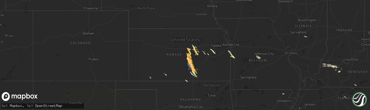
Hail Map in Kansas on September 3, 2025
The weather event in Kansas on September 3, 2025 includes Hail and Wind maps. 12 states and 173 cities were impacted and suffered possible damage. The total estimated number of properties impacted is 218,687.
Want more than just the map?
Turn this storm into a full workflow.
- Owner + property data so you know who to knock
- OnDemand branded weather history reports to win the "did we even have hail?" argument
- RoofTrace estimate so reps stop guessing numbers at the door
Bought this map? Upgrade within 7 days and we'll credit the $230. (10-15 min setup call)
Hail
Wind
218,687
Estimated number of impacted properties by a 1.00" hail or larger158,228
Estimated number of impacted properties by a 1.75" hail or larger81,060
Estimated number of impacted properties by a 2.50" hail or largerStorm reports in Kansas
Kansas
| Date | Description |
|---|---|
| 09/03/20256:58 PM CDT | Golf ball to tennis ball size hail. |
| 09/03/20256:51 PM CDT | Reported half dollar size hail as well. |
| 09/03/20256:44 PM CDT | Relayed via phone. |
| 09/03/20256:42 PM CDT | A local report indicates 1.75 inch wind near 1 N Moundridge |
| 09/03/20256:38 PM CDT | Measured from personal weather station. |
| 09/03/20256:21 PM CDT | A local report indicates 2.75 inch wind near Mcpherson |
| 09/03/20256:16 PM CDT | A local report indicates 2.00 inch wind near 1 N Mcpherson |
| 09/03/20256:14 PM CDT | A local report indicates 1.75 inch wind near 1 N Mcpherson |
| 09/03/20256:10 PM CDT | A local report indicates 1.50 inch wind near 1 N Mcpherson |
| 09/03/20256:09 PM CDT | Report from ramona. |
| 09/03/20256:04 PM CDT | Report from mping: ping pong ball |
| 09/03/20256:02 PM CDT | Two inch size hail in ramona. |
| 09/03/20256:00 PM CDT | Report from mping: quarter |
| 09/03/20255:56 PM CDT | Report from mping: quarter |
| 09/03/20255:54 PM CDT | A local report indicates 2.00 inch wind near 7 NE Carlton |
| 09/03/20255:48 PM CDT | A local report indicates 1.75 inch wind near 8 S Abilene |
| 09/03/20255:47 PM CDT | A local report indicates 1.00 inch wind near 8 S Abilene |
| 09/03/20255:45 PM CDT | A local report indicates 1.75 inch wind near 2 SSW Assaria |
| 09/03/20255:45 PM CDT | A local report indicates 2.00 inch wind near 7 S Abilene |
| 09/03/20255:40 PM CDT | Size estimated from picture sent with quarter for scale. |
| 09/03/20255:36 PM CDT | A local report indicates 1.50 inch wind near Assaria |
| 09/03/20255:33 PM CDT | A local report indicates 1.50 inch wind near Assaria |
| 09/03/20255:30 PM CDT | Delayed report. |
| 09/03/20255:26 PM CDT | Hail was covering the ground south of salina airport. |
| 09/03/20255:25 PM CDT | A local report indicates 1.00 inch wind near 3 WNW Abilene |
| 09/03/20255:25 PM CDT | Delayed report... Time estimated via radar. |
| 09/03/20255:20 PM CDT | A local report indicates 1.25 inch wind near 1 NW Salina |
| 09/03/20255:16 PM CDT | A local report indicates 1.50 inch wind near 4 W Salina |
| 09/03/20255:16 PM CDT | A local report indicates 2.75 inch wind near 5 NW Smolan |
| 09/03/20255:08 PM CDT | A local report indicates 1.00 inch wind near 4 W Salina |
| 09/02/20258:38 PM CDT | Relayed via emergency manager. |
| 09/02/20258:24 PM CDT | A local report indicates 1.75 inch wind near 3 SSW Downtown Wichita |
| 09/02/20258:22 PM CDT | Many ping pong ball size hailstones along with a couple of 2 inch hailstones. |
| 09/02/20258:22 PM CDT | A local report indicates 58 MPH wind near Wichita Eisenhower Airp |
| 09/02/20258:17 PM CDT | A local report indicates 1.25 inch wind near 2 SE Maize |
| 09/02/20258:17 PM CDT | A local report indicates 60 MPH wind near 2 SE Maize |
| 09/02/20258:15 PM CDT | A local report indicates 2.50 inch wind near 3 NW Downtown Wichita |
| 09/02/20258:00 PM CDT | A local report indicates 71 MPH wind near Mcconnell Air Force Bas |
| 09/02/20257:50 PM CDT | Golfball size hail covering most of the ground. |
| 09/02/20257:50 PM CDT | A local report indicates 1.75 inch wind near Halstead |
| 09/02/20257:44 PM CDT | Personal weather station recorded wind gust of 65 mph. |
| 09/02/20257:43 PM CDT | Reported a portion of paneling blown off roof of gas station. |
| 09/02/20257:42 PM CDT | Reported 70-75 mph estimated... With a small bit of paneling blown off roof of gas station. |
| 09/02/20257:42 PM CDT | Ksn news media reported golf ball size hail in park city. |
| 09/02/20257:40 PM CDT | A local report indicates 2.75 inch wind near 2 SSE Wichita |
| 09/02/20257:39 PM CDT | Relayed via emergency manager. |
| 09/02/20257:31 PM CDT | A local report indicates 1.75 inch wind near Valley Center |
| 09/02/20257:22 PM CDT | Delayed report. Time estimated from radar. |
| 09/02/20257:16 PM CDT | A local report indicates 1.75 inch wind near Sedgwick |
| 09/02/20257:10 PM CDT | A local report indicates 1.75 inch wind near 3 NE Inman |
| 09/02/20257:06 PM CDT | Reported with tennis ball size hail. |
| 09/02/20257:06 PM CDT | Reported with 60 mph winds. |
| 09/02/20257:04 PM CDT | Railroad crossing arms were ripped off from thunderstorm winds estimated around 75mph in halstead. |
| 09/02/20257:02 PM CDT | A local report indicates 1.50 inch wind near 7 WSW Mcpherson |
All States Impacted by Hail Map on September 3, 2025
Cities Impacted by Hail Map on September 3, 2025
- Linden, IA
- Jamaica, IA
- Yale, IA
- Chalmers, IN
- Wolcott, IN
- Minneola, KS
- Whiteville, TN
- Burkesville, KY
- Macon, MS
- Shuqualak, MS
- Red Boiling Springs, TN
- Moss, TN
- Whitleyville, TN
- Scooba, MS
- Ethelsville, AL
- Millport, AL
- Epes, AL
- Walnut, MS
- Emelle, AL
- Salina, KS
- Cruger, MS
- Lindsborg, KS
- Abilene, KS
- Solomon, KS
- Lexington, MS
- Harveyville, KS
- Eskridge, KS
- Plains, KS
- Hope, KS
- Assaria, KS
- Mason, TN
- Enterprise, KS
- Burlingame, KS
- Delaplaine, AR
- Peach Orchard, AR
- Marquette, KS
- Biggers, AR
- Reading, KS
- New Cambria, KS
- Gypsum, KS
- Ramona, KS
- Lost Springs, KS
- Tampa, KS
- Mcpherson, KS
- Osage City, KS
- Chapman, KS
- Meade, KS
- Galva, KS
- Falun, KS
- Lincolnville, KS
- Herington, KS
- Lyndon, KS
- Lebanon, TN
- Durham, KS
- Moundridge, KS
- Lebo, KS
- Canton, KS
- Inman, KS
- Ackerman, MS
- Watertown, TN
- Wilsey, KS
- Council Grove, KS
- Burrton, KS
- Halstead, KS
- Hesston, KS
- Mullinville, KS
- Sedgwick, KS
- Coldwater, KS
- Newton, KS
- Buhler, KS
- Valley Center, KS
- Colwich, KS
- Bentley, KS
- Maize, KS
- Wichita, KS
- Dora, AL
- Empire, AL
- Americus, KS
- Kechi, KS
- Louise, MS
- Yazoo City, MS
- Silver City, MS
- Emporia, KS
- Benton, MS
- Pickens, MS
- Warrior, AL
- Amsterdam, MO
- Mcconnell Afb, KS
- Derby, KS
- Clearwater, KS
- Adrian, MO
- Butler, MO
- Taylorville, IL
- Assumption, IL
- Hayden, AL
- Haysville, KS
- Wellington, KS
- Bremen, AL
- Peck, KS
- Goodman, MS
- Douglass, KS
- Mulvane, KS
- Rose Hill, KS
- Udall, KS
- Durant, MS
- Belle Plaine, KS
- Indianola, MS
- Oxford, KS
- Winfield, KS
- Vaughan, MS
- Inverness, MS
- Isola, MS
- Anguilla, MS
- Belzoni, MS
- Bluff City, KS
- Bucyrus, KS
- Spring Hill, KS
- Bentonia, MS
- Mount Hope, KS
- Andale, KS
- Goddard, KS
- Rolling Fork, MS
- Medford, OK
- Paola, KS
- Louisburg, KS
- Cleveland, MO
- Canton, MS
- Drexel, MO
- Freeman, MO
- Bapchule, AZ
- Ponca City, OK
- Maricopa, AZ
- Mesa, AZ
- Tempe, AZ
- Barnett, MO
- Eldon, MO
- Olean, MO
- Russellville, MO
- Eugene, MO
- Tuscumbia, MO
- Corydon, KY
- Tompkinsville, KY
- Evansville, IN
- Mount Vernon, IN
- Uniontown, KY
- Henderson, KY
- Reed, KY
- Newburgh, IN
- Boonville, IN
- Rockport, IN
- Richland, IN
- Spottsville, KY
- Owensboro, KY
- Philpot, KY
- Maceo, KY
- Lewisport, KY
- Utica, KY
- Hartford, KY
- Whitesville, KY
- Hawesville, KY
- Horse Branch, KY
- Olaton, KY
- Fordsville, KY
- Reynolds Station, KY
- Caneyville, KY
- Falls Of Rough, KY
- Hardinsburg, KY
- Archie, MO
- Allen, KS
- Allerton, IA
- Maplesville, AL
- Lawley, AL
- Randolph, AL


