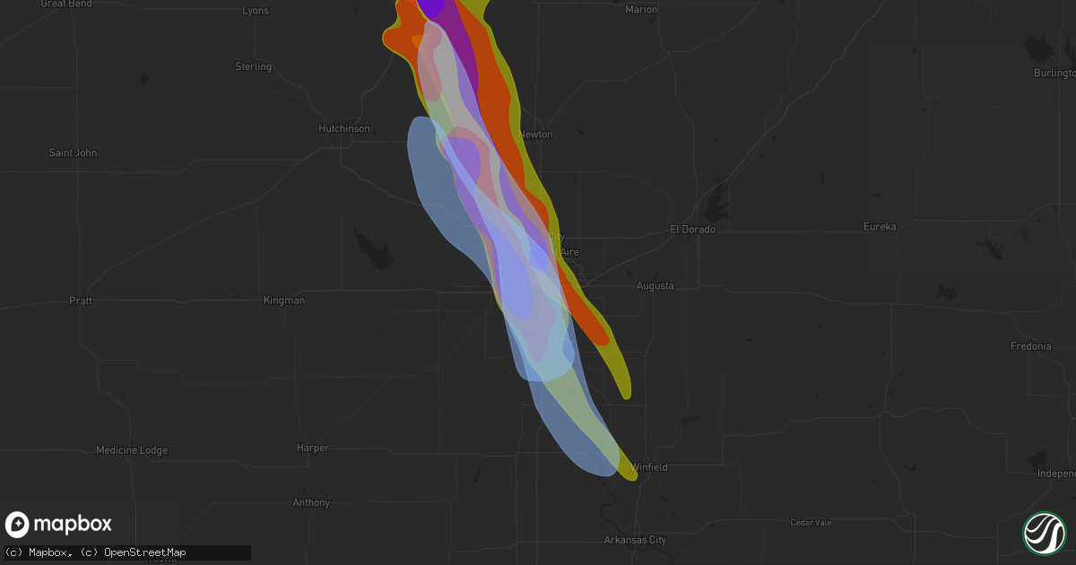
Hail Map in Wichita, KS on September 3, 2025
Get this storm
September 3 map
$229
one time, instant access
Download today. No call, no setup
Keep the $229
Bought the map and want the full workflow? Apply the entire $229 to a subscription within 7 days. None of it is wasted.
Every map, not just this one
This buys you this map. Subscription and you get every map we run, in the markets you choose from a few cities to whole states to nationwide. Plus real-time alerts the moment a storm fires.
Contact data
Name, contact info, occupancy, even credit band for addresses in the footprint. You go from where it hit to who to call.
Become the source they trust
Unlimited branding weather history reports on demand. You already have the documented answer ready for the property owner, and you are the one who showed up with it.
Property data and RoofTrace estimates
Pull up any address you have got, its value and the exact code rules for that jurisdiction, straight from One Click Code. Then RoofTrace estimates the squares, pitch, and roof value, priced the way you price.
Storm reports in Wichita, KS
Wichita, KS
| Date | Description |
|---|---|
| 09/02/20258:24 PM CDT | A local report indicates 1.75 inch wind near 3 SSW Downtown Wichita |
| 09/02/20258:22 PM CDT | Many ping pong ball size hailstones along with a couple of 2 inch hailstones. |
| 09/02/20258:22 PM CDT | A local report indicates 58 MPH wind near Wichita Eisenhower Airp |
| 09/02/20258:17 PM CDT | A local report indicates 60 MPH wind near 2 SE Maize |
| 09/02/20258:17 PM CDT | A local report indicates 1.25 inch wind near 2 SE Maize |
| 09/02/20258:15 PM CDT | A local report indicates 2.50 inch wind near 3 NW Downtown Wichita |
| 09/02/20257:43 PM CDT | Reported a portion of paneling blown off roof of gas station. |
| 09/02/20257:42 PM CDT | Reported 70-75 mph estimated... With a small bit of paneling blown off roof of gas station. |
| 09/02/20257:42 PM CDT | Ksn news media reported golf ball size hail in park city. |
| 09/02/20257:40 PM CDT | A local report indicates 2.75 inch wind near 2 SSE Wichita |
| 09/02/20257:39 PM CDT | Relayed via emergency manager. |
All States Impacted by Hail Map on September 3, 2025
All Cities Impacted by Hail Map on September 3, 2025
- Linden, IA
- Jamaica, IA
- Yale, IA
- Chalmers, IN
- Wolcott, IN
- Minneola, KS
- Whiteville, TN
- Burkesville, KY
- Macon, MS
- Shuqualak, MS
- Red Boiling Springs, TN
- Moss, TN
- Whitleyville, TN
- Scooba, MS
- Ethelsville, AL
- Millport, AL
- Epes, AL
- Walnut, MS
- Emelle, AL
- Salina, KS
- Cruger, MS
- Lindsborg, KS
- Abilene, KS
- Solomon, KS
- Lexington, MS
- Harveyville, KS
- Eskridge, KS
- Plains, KS
- Hope, KS
- Assaria, KS
- Mason, TN
- Enterprise, KS
- Burlingame, KS
- Delaplaine, AR
- Peach Orchard, AR
- Marquette, KS
- Biggers, AR
- Reading, KS
- New Cambria, KS
- Gypsum, KS
- Ramona, KS
- Lost Springs, KS
- Tampa, KS
- Mcpherson, KS
- Osage City, KS
- Chapman, KS
- Meade, KS
- Galva, KS
- Falun, KS
- Lincolnville, KS
- Herington, KS
- Lyndon, KS
- Lebanon, TN
- Durham, KS
- Moundridge, KS
- Lebo, KS
- Canton, KS
- Inman, KS
- Ackerman, MS
- Watertown, TN
- Wilsey, KS
- Council Grove, KS
- Burrton, KS
- Halstead, KS
- Hesston, KS
- Mullinville, KS
- Sedgwick, KS
- Coldwater, KS
- Newton, KS
- Buhler, KS
- Valley Center, KS
- Colwich, KS
- Bentley, KS
- Maize, KS
- Wichita, KS
- Dora, AL
- Empire, AL
- Americus, KS
- Kechi, KS
- Louise, MS
- Yazoo City, MS
- Silver City, MS
- Emporia, KS
- Benton, MS
- Pickens, MS
- Warrior, AL
- Amsterdam, MO
- Mcconnell Afb, KS
- Derby, KS
- Clearwater, KS
- Adrian, MO
- Butler, MO
- Taylorville, IL
- Assumption, IL
- Hayden, AL
- Haysville, KS
- Wellington, KS
- Bremen, AL
- Peck, KS
- Goodman, MS
- Douglass, KS
- Mulvane, KS
- Rose Hill, KS
- Udall, KS
- Durant, MS
- Belle Plaine, KS
- Indianola, MS
- Oxford, KS
- Winfield, KS
- Vaughan, MS
- Inverness, MS
- Isola, MS
- Anguilla, MS
- Belzoni, MS
- Bluff City, KS
- Bucyrus, KS
- Spring Hill, KS
- Bentonia, MS
- Mount Hope, KS
- Andale, KS
- Goddard, KS
- Rolling Fork, MS
- Medford, OK
- Paola, KS
- Louisburg, KS
- Cleveland, MO
- Canton, MS
- Drexel, MO
- Freeman, MO
- Bapchule, AZ
- Ponca City, OK
- Maricopa, AZ
- Mesa, AZ
- Tempe, AZ
- Barnett, MO
- Eldon, MO
- Olean, MO
- Russellville, MO
- Eugene, MO
- Tuscumbia, MO
- Corydon, KY
- Tompkinsville, KY
- Evansville, IN
- Mount Vernon, IN
- Uniontown, KY
- Henderson, KY
- Reed, KY
- Newburgh, IN
- Boonville, IN
- Rockport, IN
- Richland, IN
- Spottsville, KY
- Owensboro, KY
- Philpot, KY
- Maceo, KY
- Lewisport, KY
- Utica, KY
- Hartford, KY
- Whitesville, KY
- Hawesville, KY
- Horse Branch, KY
- Olaton, KY
- Fordsville, KY
- Reynolds Station, KY
- Caneyville, KY
- Falls Of Rough, KY
- Hardinsburg, KY
- Archie, MO
- Allen, KS
- Allerton, IA
- Maplesville, AL
- Lawley, AL
- Randolph, AL


