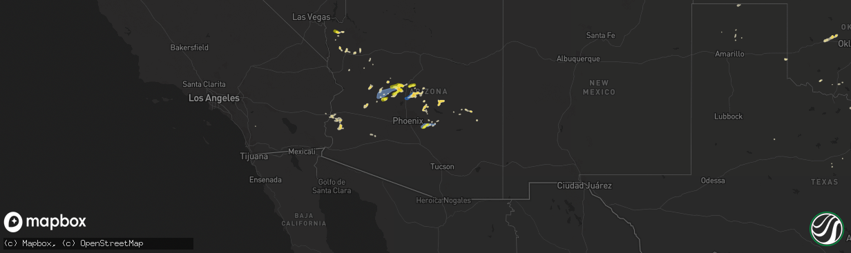
Hail Map on September 2, 2022
The weather event on September 2, 2022 includes Wind and Hail maps. 16 states and 226 cities were impacted and suffered possible damage. The total estimated number of properties impacted is 15,888.
Want more than just the map?
Turn this storm into a full workflow.
- Owner + property data so you know who to knock
- OnDemand branded weather history reports to win the "did we even have hail?" argument
- RoofTrace estimate so reps stop guessing numbers at the door
Bought this map? Upgrade within 7 days and we'll credit the $230. (10-15 min setup call)
Wind
Hail
15,888
Estimated number of impacted properties by a 1.00" hail or larger0
Estimated number of impacted properties by a 1.75" hail or larger0
Estimated number of impacted properties by a 2.50" hail or largerStates Impacted by Hail Map on September 2, 2022
Storm reports
Nebraska
| Date | Description |
|---|---|
| 09/02/20224:58 PM CDT | Trained spotter report of quarter size hail. |
| 09/01/202211:55 PM CDT | At 455 PM CDT, a severe thunderstorm was located near Wilsonville, or 23 miles east of McCook, moving south at 20 mph. HAZARD...60 mph wind gusts and quarter size hail. SOURCE...Radar indicated. IMPACT...Hail damage to vehicles is expected. Expect wind damage to roofs, siding, and trees. This severe thunderstorm will be near... Wilsonville around 510 PM CDT. |
| 09/01/202211:08 PM CDT | At 408 PM CDT, a severe thunderstorm was located 7 miles northwest of Holbrook, or 27 miles southeast of Curtis, moving south at 15 mph. HAZARD...60 mph wind gusts and quarter size hail. SOURCE...Radar indicated. IMPACT...Hail damage to vehicles is expected. Expect wind damage to roofs, siding, and trees. Locations impacted include... Cambridge and Holbrook. |
Florida
| Date | Description |
|---|---|
| 09/02/20221:18 PM CDT | Manatee co emergency management relayed that damage in a mobile home community occurred this afternoon during a thunderstorm. While a downburst did occur with this stor |
| 09/02/20221:17 PM CDT | Broadcast media reported wind damage to mobile homes in the vicinity of 53rd and chateau lane west. This damage appears to have been caused by a downburst. Time estimat |
California
| Date | Description |
|---|---|
| 09/02/20221:54 AM CDT | At 653 PM PDT, severe thunderstorms were located along a line extending from 8 miles west of Cima to 14 miles south of Mitchell Caverns, moving southwest at 20 mph. HAZARD...70 mph wind gusts and quarter size hail. SOURCE...Radar indicated. IMPACT...Hail damage to vehicles is expected. Expect considerable tree damage. Wind damage is also likely to mobile homes, roofs, and outbuildings. Locations impacted include... Kelso, Mitchell Caverns and Amboy. This includes Interstate 40 in California between mile markers 65 and91. |
Minnesota
| Date | Description |
|---|---|
| 09/02/20224:58 AM CDT | At 957 PM CDT, a severe thunderstorm was located over Rollingstone, or near Winona, moving east at 30 mph. HAZARD...60 mph wind gusts and quarter size hail. SOURCE...Radar indicated. IMPACT...Hail damage to vehicles is expected. Expect wind damage to roofs, siding, and trees. This severe thunderstorm will be near... Winona, Goodview and Fountain City around 1005 PM CDT. Arcadia around 1035 PM CDT. Galesville around 1040 PM CDT. |
Wisconsin
| Date | Description |
|---|---|
| 09/02/20226:05 PM CDT | A local report indicates 1.50 inch wind near 6 ESE DEER PARK |
| 09/02/20225:35 PM CDT | Estimated up to 1 inch size hail. Trained spotter report sent via mping. |
| 09/02/20226:44 AM CDT | At 1143 PM CDT, a severe thunderstorm was located 7 miles northwest of Waukon, moving east at 20 mph. HAZARD...60 mph wind gusts and penny size hail. SOURCE...Radar indicated. IMPACT...Expect damage to roofs, siding, and trees. This severe thunderstorm will be near... Waukon around 1205 AM CDT. Lansing around 1235 AM CDT.Other locations impacted by this severe thunderstorm include Hanover,Volney, County Roads A 52 And W 60, State Road 9 And County X 20,Waterville, County Roads X 16 And B 38 and State Road 76 And County X16. |
| 09/02/20222:47 AM CDT | At 747 PM CDT, a severe thunderstorm was located 7 miles north of Cadott, or 23 miles northeast of Eau Claire, moving east at 35 mph. HAZARD...60 mph wind gusts and quarter size hail. SOURCE...Radar indicated. IMPACT...Hail damage to vehicles is expected. Expect wind damage to roofs, siding, and trees. This severe thunderstorm will be near... Boyd around 800 PM CDT.Other locations in the path of this severe thunderstorm includeStanley. |
| 09/02/20221:15 AM CDT | At 614 PM CDT, a severe thunderstorm was located near Glenwood City, or 19 miles northwest of Menomonie, moving east at 20 mph. HAZARD...Half dollar size hail. SOURCE...Radar indicated. IMPACT...Damage to vehicles is expected. This severe thunderstorm will be near... Boyceville around 630 PM CDT. |
| 09/02/202212:58 AM CDT | At 557 PM CDT, a severe thunderstorm was located 13 miles west of Park Falls, moving southeast at 15 mph. HAZARD...Quarter size hail. SOURCE...Radar indicated. IMPACT...Damage to vehicles is expected. Locations impacted include... Fifield. |
| 09/02/202212:48 AM CDT | At 548 PM CDT, a severe thunderstorm was located near Marenisco, or 24 miles east of Ironwood, moving east at 30 mph. HAZARD...60 mph wind gusts and quarter size hail. SOURCE...Radar indicated. IMPACT...Hail damage to vehicles is expected. Expect wind damage to roofs, siding, and trees. Locations impacted include... Marenisco, Thousand Island Lake, Presque Isle Reservoir and Pomeroy Lake. |
Arkansas
| Date | Description |
|---|---|
| 09/02/20226:30 PM CDT | **delayed report** trees and limbs were down south of nimrod lake. |
Oklahoma
| Date | Description |
|---|---|
| 09/02/20221:46 AM CDT | At 646 PM CDT, a severe thunderstorm was located 4 miles south of Faxon, moving west at 10 mph. HAZARD...60 mph wind gusts and penny size hail. SOURCE...Radar indicated. IMPACT...Expect damage to roofs, siding, and trees. Locations impacted include... Chattanooga, Faxon and Loveland. |
| 09/02/202212:30 AM CDT | At 530 PM CDT, a severe thunderstorm was located 4 miles east of Hickory, moving west at 10 mph. HAZARD...60 mph wind gusts and quarter size hail. SOURCE...Radar indicated. IMPACT...Hail damage to vehicles is expected. Expect wind damage to roofs, siding, and trees. Locations impacted include... Roff, Fitzhugh, Hickory and Scullin. |
| 09/02/202212:15 AM CDT | At 515 PM CDT, a severe thunderstorm was located near Weatherford, moving southwest at 20 mph. HAZARD...60 mph wind gusts and quarter size hail. SOURCE...Radar indicated. IMPACT...Hail damage to vehicles is expected. Expect wind damage to roofs, siding, and trees. Locations impacted include... Weatherford, Clinton, Hydro, Corn and Colony. |
| 09/01/202211:41 PM CDT | At 441 PM CDT, a severe thunderstorm was located 5 miles north of Hydro, moving south at 5 mph. HAZARD...60 mph wind gusts and half dollar size hail. SOURCE...Radar indicated. IMPACT...Hail damage to vehicles is expected. Expect wind damage to roofs, siding, and trees. Locations impacted include... Weatherford and Hydro. |
| 09/01/202211:10 PM CDT | At 410 PM CDT, a severe thunderstorm was located 6 miles west of Geary, moving southwest at 15 mph. HAZARD...60 mph wind gusts and nickel size hail. SOURCE...Radar indicated. IMPACT...Expect damage to roofs, siding, and trees. Locations impacted include... Geary, Hydro, Bridgeport and Greenfield. |
Nevada
| Date | Description |
|---|---|
| 09/02/202212:23 AM CDT | At 522 PM MST, a severe thunderstorm was located 11 miles west of Pierce Ferry And Antares Roads, or 31 miles southeast of Boulder City, moving west at 20 mph. HAZARD...60 mph wind gusts and quarter size hail. SOURCE...Radar indicated. IMPACT...Hail damage to vehicles is expected. Expect wind damage to roofs and trees. Locations impacted include... White Hills and Lake Mead National Recreation Area. |
| 09/01/202211:23 PM CDT | At 422 PM MST, a severe thunderstorm was located over Golden Valley, or 12 miles west of Kingman, moving southwest at 20 mph. HAZARD...60 mph wind gusts. SOURCE...Radar indicated. IMPACT...Expect damage to roofs and trees. Locations impacted include... Bullhead City, Oatman and Golden Valley. |
Texas
| Date | Description |
|---|---|
| 09/01/202211:31 PM CDT | At 430 PM CDT, a severe thunderstorm was located 9 miles southwest of Terral, moving southwest at 10 mph. HAZARD...60 mph wind gusts and quarter size hail. SOURCE...Radar indicated. IMPACT...Hail damage to vehicles is expected. Expect wind damage to roofs, siding, and trees. Locations impacted include... Bellevue. |
Michigan
| Date | Description |
|---|---|
| 09/02/20221:58 AM CDT | At 656 PM EDT, severe thunderstorms were located along a line extending from near Keweenaw Bay to near L'anse, moving east at 35 mph. HAZARD...60 mph wind gusts. SOURCE...Radar indicated. IMPACT...Expect damage to roofs, siding, and trees. Severe thunderstorms will be near... Skanee around 710 PM EDT.Other locations in the path of these severe thunderstorms include TheHuron Islands. |
| 09/02/20221:33 AM CDT | At 632 PM EDT, a severe thunderstorm was located over Nisula, or 11 miles west of Baraga, moving east at 40 mph. HAZARD...60 mph wind gusts. SOURCE...Radar indicated. IMPACT...Expect damage to roofs, siding, and trees. This severe thunderstorm will be near... Baraga around 650 PM EDT.Other locations in the path of this severe thunderstorm includeL'anse and Keweenaw Bay. |
| 09/02/20221:13 AM CDT | At 612 PM EDT, a severe thunderstorm was located near Rockland, or 13 miles south of Ontonagon, moving east at 30 mph. HAZARD...60 mph wind gusts and quarter size hail. SOURCE...Radar indicated. IMPACT...Hail damage to vehicles is expected. Expect wind damage to roofs, siding, and trees. This severe thunderstorm will be near... Mass City around 630 PM EDT. |
| 09/02/202212:38 AM CDT | At 538 PM EDT, a severe thunderstorm was located near Keweenaw Bay, or 9 miles north of Baraga, moving east at 40 mph. HAZARD...60 mph wind gusts and quarter size hail. SOURCE...Radar indicated. IMPACT...Hail damage to vehicles is expected. Expect wind damage to roofs, siding, and trees. Locations impacted include... Baraga, Keweenaw Bay, The Lower Entrance of Portage Canal, Skanee, Arnheim, Jacobsville, Pequaming, Assinins and Point Abbaye. |
| 09/02/202212:21 AM CDT | At 521 PM CDT, a severe thunderstorm was located near Marenisco, or 18 miles east of Ironwood, moving east at 25 mph. HAZARD...60 mph wind gusts and quarter size hail. SOURCE...Radar indicated. IMPACT...Hail damage to vehicles is expected. Expect wind damage to roofs, siding, and trees. This severe thunderstorm will be near... Marenisco around 530 PM CDT. |
Arizona
| Date | Description |
|---|---|
| 09/02/20226:55 PM CDT | Called spotter and had 55 mph sustained on the hill east of the 17 with at least a 62 mph gust via weather station she has access to. Damage to smaller billboard sign a |
| 09/02/20226:20 PM CDT | Report of power outages and power poles down due to thunderstorm related wind gusts in new kingman-butler. |
| 09/02/20226:05 PM CDT | Delayed report...communications tower knocked down by the wind and over roadway shared via social media. |
| 09/02/20224:19 AM CDT | At 919 PM MST, a severe thunderstorm was located 17 miles southwest of Kofa Wildlife Refuge, or 27 miles northeast of Martinez Lake, moving southwest at 15 mph. HAZARD...60 mph wind gusts and quarter size hail. SOURCE...Radar indicated. IMPACT...Hail damage to vehicles is expected. Expect wind damage to roofs, siding, and trees. Locations impacted include... Yuma Proving Ground.This includes AZ Route 95 between mile markers 58 and 74. |
| 09/02/20223:55 AM CDT | At 855 PM MST/855 PM PDT/, severe thunderstorms were located along a line extending from near Blythe to 14 miles southwest of Kofa Wildlife Refuge, moving west at 25 mph. HAZARD...60 mph wind gusts and quarter size hail. SOURCE...Radar indicated. IMPACT...Hail damage to vehicles is expected. Expect wind damage to roofs, siding, and trees. Locations impacted include... Blythe, Quartzsite, Cibola, Palo Verde, Ripley, Blythe Airport, East Blythe and Ehrenberg.This includes the following highways...AZ Interstate 10 between mile markers 1 and 16.CA Interstate 10 between mile markers 146 and 156.AZ Route 95 between mile markers 74 and 102. |
| 09/02/20223:16 AM CDT | At 815 PM MST, a severe thunderstorm was located 16 miles west of Kofa Wildlife Refuge, or 33 miles north of Martinez Lake, moving southwest at 20 mph. HAZARD...60 mph wind gusts and quarter size hail. SOURCE...Radar indicated. IMPACT...Hail damage to vehicles is expected. Expect wind damage to roofs, siding, and trees. This severe thunderstorm will remain over mainly rural areas of southwestern La Paz and north central Yuma Counties.This includes AZ Route 95 between mile markers 81 and 100. |
| 09/02/20222:01 AM CDT | At 701 PM MST, a severe thunderstorm was located near Gladden, or 29 miles southeast of Alamo Lake, moving west at 10 mph. HAZARD...60 mph wind gusts and quarter size hail. SOURCE...Radar indicated. IMPACT...Hail damage to vehicles is expected. Expect wind damage to roofs, siding, and trees. Locations impacted include... Wenden and Gladden. This includes US Highway 60 between mile markers 60 and 79. |
| 09/02/202212:56 AM CDT | At 556 PM MST, a severe thunderstorm was located 7 miles northeast of Wickenburg, moving west at 20 mph. HAZARD...60 mph wind gusts and nickel size hail. SOURCE...Radar indicated. IMPACT...Expect damage to roofs, siding, and trees. Locations impacted include... Wickenburg.This includes the following highways...US Highway 60 between mile markers 90 and 121.AZ Route 74 between mile markers 1 and 2. |
| 09/02/202212:49 AM CDT | At 548 PM MST, severe thunderstorms were located along a line extending from near Walker to 8 miles northwest of Castle Hot Springs, moving west at 25 mph. HAZARD...60 mph wind gusts and quarter size hail. SOURCE...Radar indicated. IMPACT...Hail damage to vehicles is expected. Expect wind damage to roofs, siding, and trees. Locations impacted include... Congress, Wilhoit, Walnut Grove, Kirkland, Wagoner, Yarnell, Peeples Valley and Glen Ilah.This includes the following highways... State Route 89 between mile markers 258 and 301. State Route 71 near mile marker 109. Highway 93 between mile markers 189 and 194. |
| 09/02/202212:46 AM CDT | At 546 PM MST, a severe thunderstorm was located 14 miles east of Alamo State Park, or 15 miles east of Alamo Lake, moving southwest at 25 mph. HAZARD...60 mph wind gusts and nickel size hail. SOURCE...Radar indicated. IMPACT...Expect damage to roofs, siding, and trees. Locations impacted include... Alamo State Park. |
| 09/02/202212:39 AM CDT | At 538 PM MST, a severe thunderstorm was located near Gold Canyon, moving west at 35 mph. HAZARD...60 mph wind gusts. SOURCE...Radar indicated. IMPACT...Expect damage to roofs, siding, and trees. Locations impacted include... Mesa, Chandler, Gilbert, Tempe, Apache Junction, Gold Canyon, Sun Lakes, Queen Creek, Gold Camp, San Tan Village Mall, San Tan Valley, Seville, Freestone Park, Florence Junction and Queen Valley.This includes the following highways...AZ Interstate 10 between mile markers 156 and 160, and between milemarkers 165 and 181.US Highway 60 between mile markers 174 and 221.AZ Route 87 between mile markers 148 and 172. |
| 09/02/202212:17 AM CDT | At 517 PM MST, severe thunderstorms were located along a line extending from Mayer to near Crown King, moving west at 30 mph. HAZARD...60 mph wind gusts and quarter size hail. SOURCE...Radar indicated. IMPACT...Hail damage to vehicles is expected. Expect wind damage to roofs, siding, and trees. Locations impacted include... Cordes Junction, Bumble Bee, Cordes Lakes, Groom Creek Subdivision, Walker, Poland Junction, Cordes, Spring Valley, Ponderosa Park, Crown King, Mayer, Lower Wolf Creek Campground, Hazlett Hollow Campground, Turney Gulch Group Campground and Upper Wolf Creek Group Campground.This includes the following highways... Interstate 17 between mile markers 250 and 269. State Route 89 between mile markers 302 and 305. State Route 69 between mile markers 263 and 277. |
| 09/02/202212:07 AM CDT | At 506 PM MST, a severe thunderstorm was located 9 miles north of Superior, moving west at 15 mph. HAZARD...60 mph wind gusts and nickel size hail. SOURCE...Radar indicated. IMPACT...Expect damage to roofs, siding, and trees. Locations impacted include... Florence Junction, Queen Valley, Superstition Mountains and Gold Camp.This includes the following highways...US Highway 60 between mile markers 208 and 220.AZ Route 79 between mile markers 146 and 150. |
| 09/02/202212:03 AM CDT | At 502 PM MST, a severe thunderstorm was located 7 miles northwest of Congress, or 21 miles northwest of Wickenburg, moving southwest at 15 mph. HAZARD...60 mph wind gusts and quarter size hail. SOURCE...Radar indicated. IMPACT...Hail damage to vehicles is expected. Expect wind damage to roofs, siding, and trees. This severe thunderstorm will remain over mainly rural areas of Yavapai County.This includes the following highways... State Route 71 between mile markers 96 and 107. Highway 93 between mile markers 163 and 184. |
| 09/01/202211:47 PM CDT | At 447 PM MST, a severe thunderstorm was located 9 miles east of Black Canyon City, or 14 miles northeast of New River, moving southwest at 20 mph. HAZARD...60 mph wind gusts and nickel size hail. SOURCE...Radar indicated. IMPACT...Expect damage to roofs, siding, and trees. Locations impacted include... New River.This includes AZ Interstate 17 between mile markers 229 and 241. |
| 09/01/202211:28 PM CDT | At 427 PM MST, severe thunderstorms were located along a line extending from 12 miles northeast of Cordes Junction to near Horseshoe Reservoir, moving west at 25 mph. HAZARD...60 mph wind gusts and quarter size hail. SOURCE...Radar indicated. IMPACT...Hail damage to vehicles is expected. Expect wind damage to roofs, siding, and trees. Locations impacted include... Cordes Junction, Bumble Bee, Cordes Lakes, Black Canyon City, Rock Springs, Cordes, Horseshoe Reservoir and Spring Valley.This includes the following highways... Interstate 17 between mile markers 242 and 271. State Route 69 between mile markers 263 and 269. |
| 09/01/202210:52 PM CDT | At 351 PM MST, a severe thunderstorm was located over Skull Valley, or 10 miles west of Prescott, moving southwest at 15 mph. HAZARD...60 mph wind gusts and quarter size hail. SOURCE...Radar indicated. IMPACT...Hail damage to vehicles is expected. Expect wind damage to roofs, siding, and trees. Locations impacted include... Wilhoit, Yava, Skull Valley and Kirkland. This includes State Route 89 between mile markers 283 and 294. |
| 09/01/202210:44 PM CDT | Yuma proving ground station measured a 66 mph wind gust. |
| 09/01/202210:41 PM CDT | At 341 PM MST, a severe thunderstorm was located over New Kingman-Butler, or near Kingman, moving southwest at 15 mph. HAZARD...60 mph wind gusts and quarter size hail. SOURCE...Radar indicated. IMPACT...Hail damage to vehicles is expected. Expect wind damage to roofs and trees. Locations impacted include... Kingman, New Kingman-Butler and Golden Valley. This includes Interstate 40 in Arizona between mile markers 39 and59. |
| 09/01/202210:37 PM CDT | At 337 PM MST, a severe thunderstorm was located near Chloride, or 16 miles northwest of Kingman, moving southwest at 15 mph. HAZARD...60 mph wind gusts and quarter size hail. SOURCE...Radar indicated. IMPACT...Hail damage to vehicles is expected. Expect wind damage to roofs and trees. Locations impacted include... Golden Valley and Chloride. |
| 09/01/202210:25 PM CDT | At 325 PM MST, severe thunderstorms were located along a line extending from 6 miles northwest of Sycamore Creek to near Sunflower to near Canyon Lake, moving west at 10 mph. HAZARD...60 mph wind gusts and quarter size hail. SOURCE...Radar indicated. IMPACT...Hail damage to vehicles is expected. Expect wind damage to roofs, siding, and trees. Locations impacted include... Round Valley, Ballantine Trailhead, Sugarloaf Mountain, Sycamore Creek, Sunflower, Saguaro Lake, Canyon Lake, Goldfield Ranch, Salt River Tubing Recreation Area, Rio Verde, Horseshoe Reservoir and Fort McDowell.This includes AZ Route 87 between mile markers 193 and 223. |
| 09/01/20229:17 PM CDT | At 217 PM MST, a severe thunderstorm was located 12 miles west of Hilltop, or 19 miles northeast of Globe, moving south at 10 mph. HAZARD...60 mph wind gusts and quarter size hail. SOURCE...Radar indicated. IMPACT...Hail damage to vehicles is expected. Expect wind damage to roofs, siding, and trees. This severe thunderstorm will remain over mainly rural areas of Gila County.This includes US Highway 60 between mile markers 262 and 281. |
| 09/01/20229:17 PM CDT | At 217 PM MST, a severe thunderstorm was located 11 miles south of Young, or 21 miles northeast of Roosevelt, moving southwest at 15 mph. HAZARD...60 mph wind gusts and quarter size hail. SOURCE...Radar indicated. IMPACT...Hail damage to vehicles is expected. Expect wind damage to roofs, siding, and trees. Locations impacted include... Reynolds Creek Group Campground and Rose Creek Campground. This includes State Route 288 between mile markers 273 and 300. |
| 09/01/20228:59 PM CDT | Jeremy perez tweeted there was a couple miles... Maybe more... Of downed power lines starting about 3.5 miles northwest of wickenburg. |
| 09/01/20228:59 PM CDT | Corrects previous tstm wnd dmg report from 12 sse congress. Spotter c190 tweeted there was a couple miles... Maybe more... Of downed power lines starting about 3.5 mile |
| 09/01/20228:25 PM CDT | Lsr from phoenix spotter maa010 showing 1 1/8 inch hail with a picture included. Big hail spike on radar was at 6:09 p.m. |
| 09/01/20228:15 PM CDT | 68 mph gust measured at the stanton raws. Time estimated from radar. |
| 09/01/20228:12 PM CDT | A local report indicates 1.00 inch wind near 2 E QUEEN CREEK |
| 09/01/20228:10 PM CDT | Social media picture of a large uprooted tree. |
| 09/01/20227:55 PM CDT | Trained spotter estimated around 60 mph winds with minor tree damage. |
| 09/01/20227:53 PM CDT | Sunset point raws showed 12g72 mph at 5:53 p.m. Went back to radar and highest reflectivity at the surface was around 5:16 p.m. |
| 09/01/20227:45 PM CDT | A local report indicates 65 MPH wind near 8 SE APACHE JUNCTION |
| 09/01/20227:11 PM CDT | Time of report updated based on time of tractor trailer incident on i-17. Sunset point raws showed 12g72 mph at 5:53 p.m. Went back to radar and highest reflectivity at |
Colorado
| Date | Description |
|---|---|
| 09/02/20226:08 PM CDT | Asos station kals alamosa airport. |
| 09/02/20224:11 AM CDT | At 910 PM MDT, a severe thunderstorm was located over southwestern Denver International Airport, or 14 miles northeast of Denver, moving southeast at 30 mph. HAZARD...60 mph wind gusts. SOURCE...Radar indicated. IMPACT...Expect damage to roofs, siding, and trees. This severe thunderstorm will remain over mainly rural areas of northeastern Denver and southwestern Adams Counties. |
Kansas
| Date | Description |
|---|---|
| 09/02/20226:44 PM CDT | A local report indicates 61 MPH wind near PENOKEE |
| 09/02/20226:36 PM CDT | Approximately a foot in diameter tree limb was blown down from a cottonwood. In addition two small tents were damage. |
| 09/02/20226:00 PM CDT | 66mph wind gust measured at k-383 |
| 09/02/20225:58 PM CDT | Estimated wind gusts of 50-70 mph. |
| 09/02/20222:56 AM CDT | At 755 PM CDT, a severe thunderstorm was located near Modoc, moving south at 25 mph. HAZARD...60 mph wind gusts and quarter size hail. SOURCE...Radar indicated. IMPACT...Hail damage to vehicles is expected. Expect wind damage to roofs, siding, and trees. This severe thunderstorm will remain over mainly rural areas of northeastern Kearny, northwestern Finney and southwestern Scott Counties.This new warning for replaces the previous warning for northern Finney and Scott County. |
| 09/02/20222:43 AM CDT | At 743 PM CDT, a severe thunderstorm was located 5 miles northwest of Modoc, moving south at 20 mph. HAZARD...60 mph wind gusts and quarter size hail. SOURCE...Radar indicated. IMPACT...Hail damage to vehicles is expected. Expect wind damage to roofs, siding, and trees. This severe thunderstorm will remain over mainly rural areas of eastern Wichita County, including the following locations... Lydia and Marienthal. |
| 09/02/20222:23 AM CDT | At 722 PM CDT, the wind shift gust front ahead of severe thunderstorms was located along a line extending from near Shields to near Modoc, moving south at 50 mph. HAZARD...60 mph wind gusts and penny size hail. SOURCE...Radar indicated. IMPACT...Expect damage to roofs, siding, and trees. Severe thunderstorms will be near... Shields around 725 PM CDT. Scott City and Dighton around 730 PM CDT. Shallow Water around 740 PM CDT.Other locations in the path of these severe thunderstorms includeFriend. |
| 09/02/20222:02 AM CDT | At 701 PM CDT, severe thunderstorms were located along a line extending from 7 miles south of Hill City to near Quinter, moving south at 30 mph. HAZARD...60 mph wind gusts and penny size hail. SOURCE...Radar indicated. IMPACT...Expect damage to roofs, siding, and trees. Severe thunderstorms will be near... Collyer around 710 PM CDT.Other locations in the path of these severe thunderstorms includeWakeeney, Voda and Trego Center. |
| 09/02/20221:56 AM CDT | At 655 PM CDT, severe thunderstorms were located along a line extending from 10 miles southwest of Gove to 8 miles east of Russell Springs, moving south at 25 mph. HAZARD...60 mph wind gusts and penny size hail. SOURCE...Radar indicated. IMPACT...Expect damage to roofs, siding, and trees. Locations impacted include... Scott State Lake and Healy. |
| 09/02/20221:42 AM CDT | At 642 PM CDT, severe thunderstorms were located along a line extending from near Monument to 5 miles east of Oakley to 3 miles east of Grinnell, moving southwest at 20 mph. HAZARD...60 mph wind gusts and nickel size hail. SOURCE...Radar indicated. IMPACT...Expect damage to roofs, siding, and trees. Severe thunderstorms will be near... Monument around 650 PM CDT.Other locations in the path of these severe thunderstorms includeRussell Springs.This includes Interstate 70 in Kansas between mile markers 69 and 96. |
| 09/02/20221:33 AM CDT | At 632 PM CDT, severe thunderstorms were located along a line extending from 7 miles south of Edmond to 4 miles northeast of Morland to near Hoxie, moving southeast at 30 mph. HAZARD...60 mph wind gusts and quarter size hail. SOURCE...Radar indicated. IMPACT...Hail damage to vehicles is expected. Expect wind damage to roofs, siding, and trees. Severe thunderstorms will be near... Morland around 640 PM CDT. Hill City around 650 PM CDT.Other locations in the path of these severe thunderstorms includeBogue and Nicodemus. |
| 09/02/20221:29 AM CDT | At 629 PM CDT, a severe thunderstorm was located 7 miles north of Grinnell, moving south at 10 mph. HAZARD...60 mph wind gusts and quarter size hail. SOURCE...Radar indicated. IMPACT...Hail damage to vehicles is expected. Expect wind damage to roofs, siding, and trees. Locations impacted include... Grainfield and Grinnell.This includes Interstate 70 in Kansas between mile markers 76 and 93. |
| 09/02/20221:04 AM CDT | At 603 PM CDT, a severe thunderstorm was located near Jennings, or 17 miles southeast of Oberlin, moving south at 30 mph. HAZARD...70 mph wind gusts and nickel size hail. SOURCE...Trained weather spotters. Estimated 70 mph winds were reported in Jennings. IMPACT...Expect considerable tree damage. Damage is likely to mobile homes, roofs, and outbuildings. This severe thunderstorm will remain over mainly rural areas of northeastern Sheridan and southeastern Decatur Counties. |
| 09/02/202212:57 AM CDT | At 557 PM CDT, a severe thunderstorm was located 7 miles east of Menlo, or 7 miles west of Hoxie, moving south at 15 mph. HAZARD...60 mph wind gusts and quarter size hail. SOURCE...Radar indicated. IMPACT...Hail damage to vehicles is expected. Expect wind damage to roofs, siding, and trees. This severe thunderstorm will remain over mainly rural areas of southwestern Sheridan County, including the following locations... Seguin. |
| 09/02/202212:27 AM CDT | At 526 PM CDT, a severe thunderstorm was located 8 miles southeast of Danbury, or 12 miles northeast of Oberlin, moving south at 15 mph. HAZARD...60 mph wind gusts and quarter size hail. SOURCE...Radar indicated. IMPACT...Hail damage to vehicles is expected. Expect wind damage to roofs, siding, and trees. Locations impacted include... Norcatur. |
| 09/01/202211:54 PM CDT | At 454 PM CDT, a severe thunderstorm was located 6 miles northwest of Wilsonville, or 22 miles east of McCook, moving south at 20 mph. HAZARD...60 mph wind gusts and quarter size hail. SOURCE...Radar indicated. IMPACT...Hail damage to vehicles is expected. Expect wind damage to roofs, siding, and trees. Locations impacted include... Lebanon. |
| 09/01/202210:33 PM CDT | Mesonet station ur350 4.4 ne hayne |
| 09/01/20228:46 PM CDT | Report from mping: trees uprooted or snapped; roof blown off. |
| 09/01/20228:38 PM CDT | A local report indicates 59 MPH wind near 8 ENE GARDEN CITY |
Iowa
| Date | Description |
|---|---|
| 09/02/20226:16 AM CDT | At 1115 PM CDT, a severe thunderstorm was located near Decorah, moving east at 20 mph. HAZARD...60 mph wind gusts and quarter size hail. SOURCE...Radar indicated. IMPACT...Hail damage to vehicles is expected. Expect wind damage to roofs, siding, and trees. This severe thunderstorm will be near... Decorah around 1125 PM CDT.Other locations impacted by this severe thunderstorm include StateRoad 9 And 245th Street, County Roads W 14 And A 34, Highway 52 AndCounty W 34, Frankville, State Road 9 And Frankville Road, Nordnessand County Roads W 20 And A 34. |
Cities Impacted by Hail Map on September 2, 2022
- Winter, WI
- Marion, WI
- Clintonville, WI
- Ridgeland, WI
- Vesper, WI
- Shawano, WI
- Mosinee, WI
- Weatherford, OK
- Geary, OK
- Green Bay, WI
- Egg Harbor, WI
- Sturgeon Bay, WI
- Cornell, WI
- Pittsville, WI
- Arpin, WI
- Prairie Farm, WI
- Clayton, WI
- Dallas, WI
- Barron, WI
- Wausau, WI
- Rothschild, WI
- La Farge, WI
- Ontario, WI
- Holmen, WI
- Bruce Crossing, MI
- Ewen, MI
- Shiocton, WI
- Selden, KS
- Kingman, AZ
- Golden Valley, AZ
- Land O'Lakes, WI
- Marenisco, MI
- Clear Lake, WI
- Glenwood City, WI
- Deer Park, WI
- Stewartville, MN
- Holly, CO
- Nekoosa, WI
- Jim Falls, WI
- Melrose, IA
- Mystic, IA
- Plano, IA
- Moravia, IA
- Westby, WI
- Cashton, WI
- Coon Valley, WI
- Norwalk, WI
- Kirkland, AZ
- Skull Valley, AZ
- Pencil Bluff, AR
- Oden, AR
- Harvey, AR
- Mount Ida, AR
- Ranger, TX
- Desdemona, TX
- Yucca, AZ
- Wickenburg, AZ
- Gruver, TX
- Arcadia, WI
- Ettrick, WI
- Stratford, WI
- Antigo, WI
- Eyota, MN
- Dover, MN
- Mass City, MI
- Hackberry, AZ
- Congress, AZ
- Muenster, TX
- Baldwin, WI
- Fountain City, WI
- Channing, TX
- Hoxie, KS
- Hollandale, WI
- Bird City, KS
- Racine, MN
- Grand Meadow, MN
- Rollingstone, MN
- Minnesota City, MN
- Dodge, WI
- Altura, MN
- Winona, MN
- Saint Charles, MN
- Utica, MN
- Lebanon, NE
- Waldron, AR
- Hill City, KS
- Jennings, KS
- Dresden, KS
- Clayton, KS
- Penokee, KS
- Norcatur, KS
- Morland, KS
- Oberlin, KS
- Albia, IA
- Wakefield, MI
- Exeland, WI
- Hartsville, TN
- Dixon Springs, TN
- La Crosse, WI
- Oakley, KS
- Kit Carson, CO
- Bartley, NE
- Gamaliel, KY
- Lafayette, TN
- Red Boiling Springs, TN
- Cresco, IA
- Manitowish Waters, WI
- Grinnell, KS
- Plainview, AR
- Rose Creek, MN
- Dexter, MN
- Elkton, MN
- Adams, MN
- Taopi, MN
- Ogema, WI
- Prentice, WI
- Brantwood, WI
- Appleton, WI
- Greenville, WI
- Hortonville, WI
- Kensett, IA
- Hanlontown, IA
- Manly, IA
- Grand Marsh, WI
- Adams, WI
- Wisconsin Dells, WI
- New Auburn, WI
- Rhinelander, WI
- West Salem, WI
- Bangor, WI
- Sparta, WI
- Rockland, WI
- Roff, OK
- Wellington, TX
- Menomonie, WI
- Elk Mound, WI
- Sunray, TX
- Presque Isle, WI
- New Franken, WI
- Mcalester, OK
- Stuart, OK
- Aniwa, WI
- Ringle, WI
- Coalgate, OK
- Meadview, AZ
- Frederick, OK
- Cambridge, NE
- Leoti, KS
- Atwood, KS
- Mayer, AZ
- Crown King, AZ
- Ontonagon, MI
- Stephenville, TX
- Fort Mcdowell, AZ
- Scottsdale, AZ
- Marienthal, KS
- Lovilia, IA
- Cope, CO
- De Leon, TX
- Dolan Springs, AZ
- Buckeye, AZ
- Promise City, IA
- Scott City, KS
- Waukon, IA
- Bellevue, TX
- Bowie, TX
- Willow Beach, AZ
- San Tan Valley, AZ
- Saint Jo, TX
- San Carlos, AZ
- Waterloo, IA
- Cedar Falls, IA
- Decorah, IA
- Brownsville, MN
- Hokah, MN
- Pelkie, MI
- Queen Creek, AZ
- Gold Canyon, AZ
- Wellton, AZ
- Dry Creek, LA
- Kinder, LA
- Salome, AZ
- Eustis, NE
- Wilsonville, NE
- Oskaloosa, IA
- Tracy, IA
- Curtis, NE
- Walters, OK
- Peridot, AZ
- Ringgold, TX
- Ridgeway, IA
- Pauma Valley, CA
- Yarnell, AZ
- Chaseburg, WI
- Seymour, IA
- Bussey, IA
- Black Canyon City, AZ
- Eagle River, WI
- Wilson, WI
- Woodville, WI
- Spring Valley, WI
- Lenora, KS
- Baraga, MI
- Wardville, OK
- Holton, IN
- Montgomery, TX
- Stoddard, WI
- Herndon, KS
- Rotan, TX
- McDonald, KS
- La Crescent, MN
- McCook, NE
- Saint Ignace, MI
- Hudson, IA
- Grant, LA
- Pitkin, LA
- Plover, WI
- Bancroft, WI
- Blythe, CA
- Forestburg, TX
- Mesa, AZ
- Park Falls, WI
- Ojibwa, WI
- Downing, WI
- Boyceville, WI
- Prescott, AZ