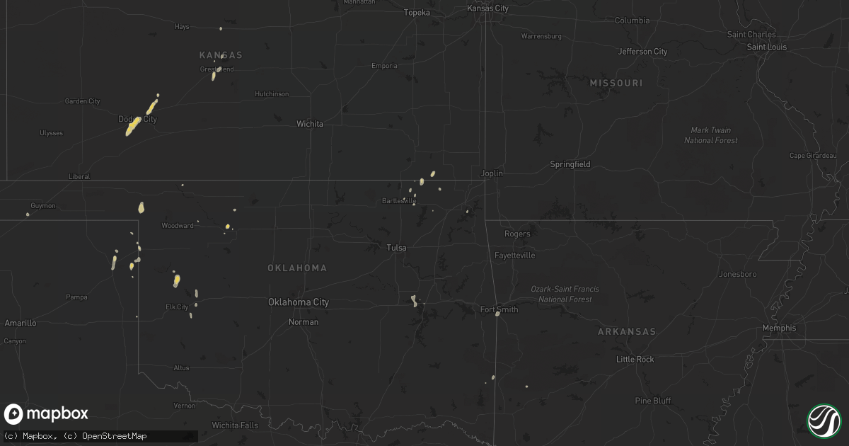
Hail Map on September 1, 2022
Get this storm
September 1 map
$229
one time, instant access
Download today. No call, no setup
Keep the $229
Bought the map and want the full workflow? Apply the entire $229 to a subscription within 7 days. None of it is wasted.
Every map, not just this one
This buys you this map. Subscription and you get every map we run, in the markets you choose from a few cities to whole states to nationwide. Plus real-time alerts the moment a storm fires.
Contact data
Name, contact info, occupancy, even credit band for addresses in the footprint. You go from where it hit to who to call.
Become the source they trust
Unlimited branding weather history reports on demand. You already have the documented answer ready for the property owner, and you are the one who showed up with it.
Property data and RoofTrace estimates
Pull up any address you have got, its value and the exact code rules for that jurisdiction, straight from One Click Code. Then RoofTrace estimates the squares, pitch, and roof value, priced the way you price.
States Impacted by Hail Map on September 1, 2022
Storm reports
Kansas
| Date | Description |
|---|---|
| 09/01/20223:16 PM CDT | Tree reported blown down by thunderstorm wind. |
| 09/01/20223:04 PM CDT | Numerous tree limbs downed. Pea size hail too. |
| 09/01/20223:34 AM CDT | At 834 PM CDT, a severe thunderstorm was located 8 miles southeast of Ensign, moving southwest at 25 mph. HAZARD...60 mph wind gusts and penny size hail. SOURCE...Radar indicated. IMPACT...Expect damage to roofs, siding, and trees. Locations impacted include... Fowler and Meade. |
| 09/01/20222:44 AM CDT | At 743 PM CDT, a severe thunderstorm was located near Dodge City, moving southwest at 20 mph. HAZARD...60 mph wind gusts and penny size hail. SOURCE...Radar indicated. IMPACT...Expect damage to roofs, siding, and trees. This severe thunderstorm will remain over mainly rural areas of southwestern Ford County. |
| 09/01/20222:32 AM CDT | At 732 PM CDT, a severe thunderstorm was located over Great Bend, moving south at 10 mph. HAZARD...60 mph wind gusts and quarter size hail. SOURCE...Radar indicated. IMPACT...Hail damage to vehicles is expected. Expect wind damage to roofs, siding, and trees. Locations impacted include... Great Bend and Great Bend Airport. |
| 08/31/202210:06 PM CDT | At 306 PM CDT, a severe thunderstorm was located near Edna, or 10 miles east of Coffeyville, moving north at 15 mph. HAZARD...60 mph wind gusts and nickel size hail. SOURCE...Radar indicated. IMPACT...Expect damage to roofs, siding, and trees. Locations impacted include... Coffeyville, Altamont, Edna, Dearing, Mound Valley, Liberty, Angola, Coffeyville Airport and Big Hill Lake. |
| 08/31/20227:45 PM CDT | A couple of large 12 inch diameter tree branches broke. |
| 08/31/20227:44 PM CDT | Power lines down. |
| 08/31/20227:40 PM CDT | Report of a roof being blown off a building. |
| 08/31/20227:35 PM CDT | Ksn tv reports... Rv campers were rolled over by damaging winds. Delayed report. |
| 08/31/20227:35 PM CDT | Several large tree limbs down in town. |
Texas
| Date | Description |
|---|---|
| 09/01/20221:40 PM CDT | A member of the public reported a downed tree which damaged a fence and truck as downburst winds from a nearby thunderstorm moved through the area. |
| 09/01/20221:52 AM CDT | At 651 PM CDT, a severe thunderstorm was located 5 miles west of Glazier, or 7 miles north of Canadian, moving southwest at 10 mph. HAZARD...60 mph wind gusts and quarter size hail. SOURCE...Radar indicated. IMPACT...Minor damage to roofs, siding, and trees is possible. Hail damage to vehicles is expected. Locations impacted include... Canadian, Glazier and Lake Marvin. |
| 09/01/20221:41 AM CDT | At 641 PM CDT, a severe thunderstorm was located near Goodwell, or 14 miles southwest of Guymon, moving south at 5 mph. HAZARD...60 mph wind gusts and quarter size hail. SOURCE...Radar indicated. IMPACT...Minor damage to roofs, siding, and trees is possible. Hail damage to vehicles is expected. Locations impacted include... Goodwell and Texhoma. |
| 09/01/202212:40 AM CDT | At 540 PM CDT, a severe thunderstorm was located near Slapout, or 17 miles southwest of Laverne, and is nearly stationary. HAZARD...60 mph wind gusts and penny size hail. SOURCE...Radar indicated. IMPACT...Minor damage to roofs, siding, and trees is possible. Locations impacted include... Slapout. |
| 08/31/202210:58 PM CDT | At 358 PM CDT, a severe thunderstorm was located 6 miles south of Follett, or 12 miles northeast of Lipscomb, moving east at 10 mph. HAZARD...60 mph wind gusts and quarter size hail. SOURCE...Radar indicated. IMPACT...Minor damage to roofs, siding, and trees is possible. Hail damage to vehicles is expected. Locations impacted include... Follett. |
| 08/31/20227:11 PM CDT | Sheriff office reported a few trees down in canadian. Time estimated by radar. |
Georgia
| Date | Description |
|---|---|
| 09/01/20224:45 PM CDT | Trees down near trumpington ln and w alberson dr. |
| 09/01/20224:40 PM CDT | Wires down near old dawson rd and n doublegate dr. |
| 09/01/20224:35 PM CDT | Tree limbs were blown into the roadway at ga-520 and wingate lane... Temporarily closing all travel lanes. |
| 09/01/20224:03 PM CDT | A tree down from an outflow boundary that went through the area. Time estimated based on radar. |
| 09/01/20223:39 PM CDT | Two trees down from an outflow boundary that went through the area. Time estimated based on radar. |
| 09/01/202212:30 AM CDT | At 530 PM EDT, a severe thunderstorm was located near Albany, moving south at 30 mph. HAZARD...60 mph wind gusts. SOURCE...Radar indicated. IMPACT...Expect damage to roofs, siding, and trees. Locations impacted include... Putney, Albany, East Albany, Marine Corps Logistics Base, Turner City, Walker, Stocks, Radium Springs, Forrester, Lockett Crossing, South Albany, Southwest Ga Regional A/P, Palmyra, Century, Pecan City, Herod, Ducker, Armena, Williamsburg and Chickasawhatchee. |
| 08/31/202211:42 PM CDT | At 441 PM EDT, a severe thunderstorm was located near Lake Park, moving northeast at 20 mph. HAZARD...60 mph wind gusts. SOURCE...Radar indicated. IMPACT...Expect damage to roofs, siding, and trees. Locations impacted include... Lake Park. |
| 08/31/202211:41 PM CDT | At 441 PM EDT, a severe thunderstorm was located near Yulee, or 8 miles southwest of St. Marys, moving northwest at 10 mph. HAZARD...60 mph wind gusts and penny size hail. SOURCE...Radar indicated. IMPACT...Expect damage to roofs, siding, and trees. Locations impacted include... St. Marys and Yulee. |
| 08/31/202210:29 PM CDT | At 329 PM EDT, a severe thunderstorm was located near Gough, or 8 miles east of Louisville, moving northwest at 10 mph. HAZARD...60 mph wind gusts and quarter size hail. SOURCE...Radar indicated. IMPACT...Hail damage to vehicles is expected. Expect wind damage to trees and powerlines. Locations impacted include... Waynesboro, Midville, Alexander, Gough, Burke County Airport, Blythe, Keysville, Vidette, Di- Lane Wildlife Management Area, Magruder and Rosier. |
| 08/31/20229:40 PM CDT | At 239 PM EDT, a severe thunderstorm was located over Oconee, or 10 miles southwest of Sandersville, and is nearly stationary. HAZARD...60 mph wind gusts and penny size hail. SOURCE...Radar indicated. IMPACT...Expect damage to roofs, siding, and trees. Locations impacted include... Tennille, Oconee and Hebron. |
Florida
| Date | Description |
|---|---|
| 09/01/20223:55 PM CDT | Orlando executive airport measured a wind gust from the southeast at 54kt/62mph. |
| 09/01/20223:55 PM CDT | *** 1 fatal... 1 inj *** severe wind gusts... Measured up to 62 mph at the orlando executive airport... Overturned two small private aircraft. One plane was unoccupied. |
| 09/01/20222:40 PM CDT | Tree reported down at altama rd and grove park blvd. Wires reported down. |
| 09/01/20222:00 PM CDT | Large tree uprooted from wind gust. Ground was saturated making it easier for the tree to fall. Located between orange park and middleburg. Time was estimated by radar. |
| 09/01/20221:45 PM CDT | Corrects previous tstm wnd dmg report from 4 nw guana river state park. Large tree snapped near the base in twenty mile village. Stop sign blown over along eagle rock d |
| 09/01/20221:45 PM CDT | Tree reported down within twenty mile... Nocatee. |
| 08/31/202211:46 PM CDT | At 446 PM EDT, a severe thunderstorm was located over Azalea Park, moving northwest at 15 mph. HAZARD...60 mph wind gusts. SOURCE...Radar indicated. IMPACT...Expect damage to roofs, siding, and trees. Locations impacted include... Orlando, Altamonte Springs, Oviedo, Winter Springs and Winter Park. |
| 08/31/202210:07 PM CDT | At 306 PM EDT, a severe thunderstorm was located near Ocala, moving northeast at 15 mph. HAZARD...60 mph wind gusts and penny size hail. SOURCE...Radar indicated. IMPACT...Expect damage to roofs, siding, and trees. Locations impacted include... Ocala, Anthony, Reddick and Lowell. |
Oklahoma
| Date | Description |
|---|---|
| 09/01/20224:59 AM CDT | At 958 PM CDT, a severe thunderstorm was located 5 miles southeast of Quail, or 6 miles west of Wellington, moving south at 25 mph. HAZARD...60 mph wind gusts. SOURCE...Radar indicated. IMPACT...Expect damage to roofs, siding, and trees. Locations impacted include... Childress, Memphis and Estelline. |
| 09/01/20224:35 AM CDT | At 935 PM CDT, a severe thunderstorm was located 4 miles southwest of Samnorwood, or 13 miles northwest of Wellington, moving south at 55 mph. HAZARD...60 mph wind gusts. SOURCE...Radar indicated. IMPACT...Minor damage to roofs, siding, and trees is possible. Locations impacted include... Wellington, Dodson, Dozier, Lutie, Samnorwood and Quail. |
| 09/01/20223:06 AM CDT | At 805 PM CDT, a severe thunderstorm was located near Rocky, moving southeast at 15 mph. HAZARD...60 mph wind gusts. SOURCE...Radar indicated. IMPACT...Expect damage to roofs, siding, and trees. Locations impacted include... Hobart, Sentinel, Lone Wolf, Gotebo and Rocky. |
| 09/01/20222:24 AM CDT | At 723 PM CDT, a severe thunderstorm was located near Burns Flat, moving southeast at 20 mph. HAZARD...60 mph wind gusts and nickel size hail. SOURCE...Radar indicated. IMPACT...Expect damage to roofs, siding, and trees. Locations impacted include... Cordell, Burns Flat, Sentinel, Dill City, Canute, Bessie and Rocky. |
| 09/01/202212:44 AM CDT | At 544 PM CDT, a severe thunderstorm was located near Moorewood, moving south at 5 mph. HAZARD...60 mph wind gusts and quarter size hail. SOURCE...Radar indicated. IMPACT...Hail damage to vehicles is expected. Expect wind damage to roofs, siding, and trees. Locations impacted include... Moorewood. |
| 09/01/202212:29 AM CDT | At 529 PM CDT, a severe thunderstorm was located 7 miles southeast of Slapout, moving south at 10 mph. HAZARD...60 mph wind gusts and quarter size hail. SOURCE...Radar indicated. IMPACT...Hail damage to vehicles is expected. Expect wind damage to roofs, siding, and trees. Locations impacted include... Catesby. |
| 09/01/202212:05 AM CDT | At 505 PM CDT, a severe thunderstorm was located near Higgins, moving southeast at 5 mph. HAZARD...60 mph wind gusts and quarter size hail. SOURCE...Radar indicated. IMPACT...Hail damage to vehicles is expected. Expect wind damage to roofs, siding, and trees. This severe thunderstorm will remain over mainly rural areas of west central Ellis County. |
| 08/31/202211:49 PM CDT | At 449 PM CDT, a severe thunderstorm was located near Laverne, moving southeast at 5 mph. HAZARD...60 mph wind gusts and quarter size hail. SOURCE...Radar indicated. IMPACT...Hail damage to vehicles is expected. Expect wind damage to roofs, siding, and trees. Locations impacted include... Laverne, May and Catesby. |
| 08/31/20229:53 PM CDT | At 252 PM CDT, a severe thunderstorm was located 8 miles northwest of Orienta, and is nearly stationary. HAZARD...60 mph wind gusts and quarter size hail. SOURCE...Radar indicated. IMPACT...Hail damage to vehicles is expected. Expect wind damage to roofs, siding, and trees. This severe thunderstorm will remain over mainly rural areas of southeastern Woods, southwestern Alfalfa and central Major Counties. |
| 08/31/20229:35 PM CDT | Mesonet station mang mangum. |
| 08/31/20227:32 PM CDT | Asos station kcsm clinton. |
Arizona
| Date | Description |
|---|---|
| 09/01/20225:41 AM CDT | At 1041 PM MST, a severe thunderstorm was located over Bapchule, or near Sun Lakes, moving southwest at 25 mph. HAZARD...60 mph wind gusts. SOURCE...Radar indicated. IMPACT...Expect damage to roofs, siding, and trees. Locations impacted include... Chandler, Sun Lakes, Maricopa, Bapchule, Estrella Sailport, Olberg, Ak-Chin Village, Santan and Sacaton.This includes the following highways...AZ Interstate 10 between mile markers 165 and 179.AZ Route 87 between mile markers 151 and 162.AZ Route 238 between mile markers 37 and 44. |
| 09/01/20224:43 AM CDT | At 943 PM MST, severe thunderstorms were located along a line extending from Gold Camp to 10 miles south of Superior, moving southwest at 25 mph. HAZARD...60 mph wind gusts. SOURCE...Radar indicated. IMPACT...Expect damage to roofs, siding, and trees. Locations impacted include... Mesa, Chandler, Gilbert, Apache Junction, Florence, Coolidge, Superior, Gold Canyon, Queen Creek, Gold Camp, Lost Dutchman State Park, Goldfield, San Tan Village Mall, San Tan Valley and Seville.This includes the following highways...US Highway 60 between mile markers 186 and 230.AZ Route 87 between mile markers 133 and 136, and between milemarkers 161 and 168.AZ Route 202 between mile markers 28 and 52. |
| 08/31/202210:35 PM CDT | Delayed report. 5-6 trees 20 to 30 ft tall downed on johnson ranch blvd. Time estimated from radar. |
| 08/31/202210:34 PM CDT | Delayed report. 30x70ft roof peeled off bus barn at poston butte hs. Stacked wooden pallets tossed 150 ft. Damage to equipment and supplies. Time estimated from radar. |
Cities Impacted by Hail Map on September 1, 2022
- Walterboro, SC
- Green Pond, SC
- Pittsburg, TX
- Ruffin, SC
- Jacksonville, GA
- Milan, GA
- Great Bend, KS
- Waynesboro, GA
- Higgins, TX
- Round O, SC
- Cordele, GA
- Leedey, OK
- Mooreland, OK
- Italy, TX
- Forreston, TX
- Estill, SC
- Leesburg, GA
- Lumpkin, GA
- Richland, GA
- Ideal, GA
- Oglethorpe, GA
- Spearville, KS
- Laverne, OK
- Canadian, TX
- Ensign, KS
- Dodge City, KS
- Louisville, GA
- Bogata, TX
- Deport, TX
- Fort Valley, GA
- Roberta, GA
- Fitzgerald, GA
- Rhine, GA
- Hammon, OK
- Tyler, TX
- Rupert, GA
- Saint Charles, IA
- Guyton, GA
- Vienna, GA
- Byromville, GA
- Lyons, GA
- Texhoma, OK
- Girard, GA
- Milledgeville, GA
- Follett, TX
- Texarkana, AR
- Bonaire, GA
- Kathleen, GA
- Perry, GA
- Delaware, OK
- Oakfield, GA
- Fairview, OK
- Pembroke, GA
- Buena Vista, GA
- Swainsboro, GA
- Nowata, OK
- Crescent City, FL
- Pomona Park, FL
- Arnett, OK
- Clinton, OK
- Mauk, GA
- Marshall, TX
- Brooklet, GA
- Wadmalaw Island, SC
- St John, KS
- Jacksonboro, SC
- Waynoka, OK
- Edna, KS
- Coffeyville, KS
- Wadley, GA
- Clarksville, TX
- S Coffeyville, OK
- Shattuck, OK
- Sparta, GA
- Gray, GA
- Brownsboro, TX
- Prole, IA
- Winterset, IA
- Hanston, KS
- Dacoma, OK
- Ocala, FL
- Smithville, OK
- Varnville, SC
- Early Branch, SC
- Johns Island, SC
- Council Hill, OK
- Eufaula, OK
- Checotah, OK
- Bunker Hill, KS
- Wright, KS
- Afton, OK
- Plantersville, TX
- Reynolds, GA
- Hollywood, SC
- Sardis, GA
- Bartlesville, OK
- Smoaks, SC
- Ailey, GA
- Mount Vernon, GA
- Green Cove Springs, FL
- Rochelle, GA
- Pineview, GA
- Dunnellon, FL
- Tennille, GA
- Sandersville, GA
- Collins, GA
- Millen, GA
- Foss, OK
- Dill City, OK
- Bartow, GA
- Ravenel, SC
- Yemassee, SC
- Hope, AR
- Orlando, FL
- Moore Haven, FL
- Montgomery, TX
- Albany, GA
- Lenapah, OK
- Montezuma, GA
- Conroe, TX
- Wann, OK
- Claflin, KS
- Hoisington, KS
- Sylvania, GA
- Arkoma, OK
- Fort Smith, AR
- Pocola, OK
- Linden, TX
- Welch, OK
- Ambrose, GA