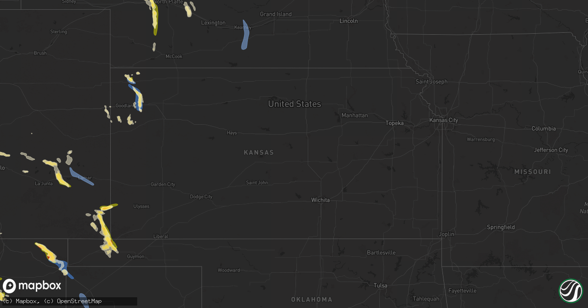
Hail Map in Kansas on August 29, 2025
Get this storm
August 29 map
$229
one time, instant access
Download today. No call, no setup
Keep the $229
Bought the map and want the full workflow? Apply the entire $229 to a subscription within 7 days. None of it is wasted.
Every map, not just this one
This buys you this map. Subscription and you get every map we run, in the markets you choose from a few cities to whole states to nationwide. Plus real-time alerts the moment a storm fires.
Contact data
Name, contact info, occupancy, even credit band for addresses in the footprint. You go from where it hit to who to call.
Become the source they trust
Unlimited branding weather history reports on demand. You already have the documented answer ready for the property owner, and you are the one who showed up with it.
Property data and RoofTrace estimates
Pull up any address you have got, its value and the exact code rules for that jurisdiction, straight from One Click Code. Then RoofTrace estimates the squares, pitch, and roof value, priced the way you price.
Storm reports in Kansas
Kansas
| Date | Description |
|---|---|
| 08/29/20256:59 PM CDT | A semi truck was blown over on westbound i-70 southwest of brewster in sherman county per an em report. |
| 08/29/20256:58 PM CDT | A powerline was reported down in brewster per em. |
| 08/29/20256:57 PM CDT | Em reports ping pong ball hail in brewster. |
| 08/29/20255:33 PM CDT | Ambient weather site hendricks_1420_road_25. |
| 08/28/20257:12 PM CDT | Report of a semi truck blown over on i-70 at mile marker 7. |
| 08/28/20257:00 PM CDT | A chicken coop was blown away in brewster. |
All States Impacted by Hail Map on August 29, 2025
Cities Impacted by Hail Map on August 29, 2025
- Espanola, NM
- Capitan, NM
- Lincoln, NM
- Chiefland, FL
- Embudo, NM
- Ohkay Owingeh, NM
- Chimayo, NM
- Weed, NM
- Hope, NM
- Pinon, NM
- Truchas, NM
- Cordova, NM
- Santa Fe, NM
- Corona, NM
- Miami, NM
- Mora, NM
- Cimarron, NM
- Weston, CO
- Hamilton, TX
- Trinidad, CO
- Bellevue, ID
- Springer, NM
- Rainsville, NM
- Buena Vista, NM
- Grenville, NM
- Mullin, TX
- Round Mountain, TX
- Garnavillo, IA
- Walsh, CO
- Taylor, NE
- Wagon Mound, NM
- Burwell, NE
- Two Buttes, CO
- Clayton, NM
- Nordman, ID
- Fountain, CO
- Hagerman, NM
- Elida, NM
- Manter, KS
- Priest River, ID
- Saint Francis, KS
- Valentine, NE
- Roy, NM
- Boone, CO
- Bliss, ID
- Bird City, KS
- Coolin, ID
- Lovington, NM
- Johnstown, NE
- Midland, TX
- Campo, CO
- Olney Springs, CO
- McDonald, KS
- Artesia, NM
- Springfield, CO
- Ramah, CO
- Solano, NM
- Sargent, NE
- Conchas Dam, NM
- Edson, KS
- Sandpoint, ID
- Rosanky, TX
- Ainsworth, NE
- Portales, NM
- Texline, TX
- Comstock, NE
- Colby, KS
- Elyria, NE
- Ord, NE
- Sagle, ID
- Harwood, TX
- Dale, TX
- Keyes, OK
- Brewster, KS
- Milnesand, NM
- Ordway, CO
- Odessa, TX
- Melrose, NM
- Thedford, NE
- Arcadia, NE
- Rogers, NM
- Goodwell, OK
- Tucumcari, NM
- Mosquero, NM
- Sutherland, NE
- Clark Fork, ID
- Hobbs, NM
- Clovis, NM
- Roswell, NM
- Loup City, NE
- Tryon, NE
- Stapleton, NE
- Eads, CO
- Sugar City, CO
- Arlington, CO
- Hershey, NE
- Okeechobee, FL
- Pep, NM
- Wallace, NE
- Haswell, CO
- Dickens, NE
- Paxton, NE
- Texhoma, OK
- Burlington, CO
- Las Animas, CO
- Texico, NM
- Ansley, NE
- Bovina, TX
- Goodland, KS
- Causey, NM
- Logan, NM
- Sharon Springs, KS
- Wallace, KS
- Brady, NE
- Arnold, NE
- Rockville, NE
- Ravenna, NE
- Tatum, NM
- Hartley, TX
- Maxwell, NE
- Bard, NM
- Hayes Center, NE
- Weskan, KS
- McClave, CO
- Plains, TX
- Gothenburg, NE
- Hasty, CO
- Lamar, CO
- Wiley, CO
- Kearney, NE
- Minden, NE
- Palisade, NE
- Mcdonald, NM
- Axtell, NE
- Hildreth, NE
- Wilcox, NE
- Lubbock, TX
- Sudan, TX


