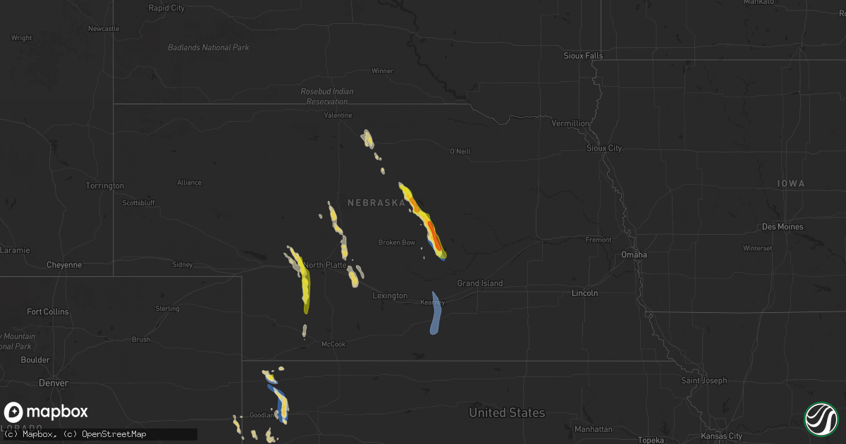
Hail Map on August 29, 2025
Get this storm
August 29 map
$229
one time, instant access
Download today. No call, no setup
Keep the $229
Bought the map and want the full workflow? Apply the entire $229 to a subscription within 7 days. None of it is wasted.
Every map, not just this one
This buys you this map. Subscription and you get every map we run, in the markets you choose from a few cities to whole states to nationwide. Plus real-time alerts the moment a storm fires.
Contact data
Name, contact info, occupancy, even credit band for addresses in the footprint. You go from where it hit to who to call.
Become the source they trust
Unlimited branding weather history reports on demand. You already have the documented answer ready for the property owner, and you are the one who showed up with it.
Property data and RoofTrace estimates
Pull up any address you have got, its value and the exact code rules for that jurisdiction, straight from One Click Code. Then RoofTrace estimates the squares, pitch, and roof value, priced the way you price.
States Impacted by Hail Map on August 29, 2025
Storm reports
New Mexico
| Date | Description |
|---|---|
| 08/29/20255:46 PM CDT | Asos station kcao clayton muni airpark. |
| 08/29/20255:06 PM CDT | A local report indicates 60 MPH wind near Clayton Lake State Park |
| 08/29/20255:05 PM CDT | Mesonet station mlcn5 mills 4 wsw |
| 08/28/20257:45 PM CDT | Mesonet station fw0979 hobbs. |
| 08/28/20257:37 PM CDT | Corrects previous non-tstm wnd gst report from 3 nw hobbs. Mesonet station 66 hobbs... Nm/ lea county. |
Colorado
| Date | Description |
|---|---|
| 08/29/20255:32 PM CDT | Tree down 400 block of maplewood in walsh. Power also out in walsh. |
| 08/29/20255:30 PM CDT | Metal roof blown off a building on county road 43. Time estimated. |
| 08/28/20258:57 PM CDT | Asos station klaa lamar airport. |
Oklahoma
| Date | Description |
|---|---|
| 08/28/20257:14 PM CDT | A local report indicates 1.50 inch wind near 3 NNW Sturgis |
Kansas
| Date | Description |
|---|---|
| 08/29/20256:59 PM CDT | A semi truck was blown over on westbound i-70 southwest of brewster in sherman county per an em report. |
| 08/29/20256:58 PM CDT | A powerline was reported down in brewster per em. |
| 08/29/20256:57 PM CDT | Em reports ping pong ball hail in brewster. |
| 08/29/20255:33 PM CDT | Ambient weather site hendricks_1420_road_25. |
| 08/28/20257:12 PM CDT | Report of a semi truck blown over on i-70 at mile marker 7. |
| 08/28/20257:00 PM CDT | A chicken coop was blown away in brewster. |
Idaho
| Date | Description |
|---|---|
| 08/29/20256:40 PM CDT | A local report indicates 1.00 inch wind near 4 SSE Dover |
| 08/29/20256:36 PM CDT | Wind gust 43 mph... 0.45 of rain 20 minutes. |
| 08/29/20256:31 PM CDT | Report from mping: quarter |
Nebraska
| Date | Description |
|---|---|
| 08/28/202510:44 PM CDT | A local report indicates 62 MPH wind near 4 WSW Minden |
| 08/28/20259:44 PM CDT | A local report indicates 61 MPH wind near Kearney Airport |
| 08/28/20257:30 PM CDT | Some small branches were downed onto highway 58 just northwest of town. Time |
| 08/28/20257:30 PM CDT | Some small branches were downed onto highway 58 just northwest of town. Time est from radar. |
| 08/28/20257:17 PM CDT | Report via spotter network. |
| 08/28/20257:17 PM CDT | Relayed via emergency manager. |
| 08/28/20257:15 PM CDT | A local report indicates 1.25 inch wind near Sutherland |
Texas
| Date | Description |
|---|---|
| 08/29/20256:14 PM CDT | First severe wind gust occurred at 6:13 pm and last severe wind gust occurred at 6:15 pm. |
| 08/28/20258:12 PM CDT | The first severe wind gust occurred at 8:07 pm. |
| 08/28/20257:15 PM CDT | Broken power pole at hwy 385 |
| 08/28/20257:02 PM CDT | Corrects previous non-tstm wnd gst report from 1 nw midland international. Asos station kmaf midland. |
Rhode Island
| Date | Description |
|---|---|
| 08/29/202511:50 AM CDT | Tree and wires down. |
Cities Impacted by Hail Map on August 29, 2025
- Espanola, NM
- Capitan, NM
- Lincoln, NM
- Chiefland, FL
- Embudo, NM
- Ohkay Owingeh, NM
- Chimayo, NM
- Weed, NM
- Hope, NM
- Pinon, NM
- Truchas, NM
- Cordova, NM
- Santa Fe, NM
- Corona, NM
- Miami, NM
- Mora, NM
- Cimarron, NM
- Weston, CO
- Hamilton, TX
- Trinidad, CO
- Bellevue, ID
- Springer, NM
- Rainsville, NM
- Buena Vista, NM
- Grenville, NM
- Mullin, TX
- Round Mountain, TX
- Garnavillo, IA
- Walsh, CO
- Taylor, NE
- Wagon Mound, NM
- Burwell, NE
- Two Buttes, CO
- Clayton, NM
- Nordman, ID
- Fountain, CO
- Hagerman, NM
- Elida, NM
- Manter, KS
- Priest River, ID
- Saint Francis, KS
- Valentine, NE
- Roy, NM
- Boone, CO
- Bliss, ID
- Bird City, KS
- Coolin, ID
- Lovington, NM
- Johnstown, NE
- Midland, TX
- Campo, CO
- Olney Springs, CO
- McDonald, KS
- Artesia, NM
- Springfield, CO
- Ramah, CO
- Solano, NM
- Sargent, NE
- Conchas Dam, NM
- Edson, KS
- Sandpoint, ID
- Rosanky, TX
- Ainsworth, NE
- Portales, NM
- Texline, TX
- Comstock, NE
- Colby, KS
- Elyria, NE
- Ord, NE
- Sagle, ID
- Harwood, TX
- Dale, TX
- Keyes, OK
- Brewster, KS
- Milnesand, NM
- Ordway, CO
- Odessa, TX
- Melrose, NM
- Thedford, NE
- Arcadia, NE
- Rogers, NM
- Goodwell, OK
- Tucumcari, NM
- Mosquero, NM
- Sutherland, NE
- Clark Fork, ID
- Hobbs, NM
- Clovis, NM
- Roswell, NM
- Loup City, NE
- Tryon, NE
- Stapleton, NE
- Eads, CO
- Sugar City, CO
- Arlington, CO
- Hershey, NE
- Okeechobee, FL
- Pep, NM
- Wallace, NE
- Haswell, CO
- Dickens, NE
- Paxton, NE
- Texhoma, OK
- Burlington, CO
- Las Animas, CO
- Texico, NM
- Ansley, NE
- Bovina, TX
- Goodland, KS
- Causey, NM
- Logan, NM
- Sharon Springs, KS
- Wallace, KS
- Brady, NE
- Arnold, NE
- Rockville, NE
- Ravenna, NE
- Tatum, NM
- Hartley, TX
- Maxwell, NE
- Bard, NM
- Hayes Center, NE
- Weskan, KS
- McClave, CO
- Plains, TX
- Gothenburg, NE
- Hasty, CO
- Lamar, CO
- Wiley, CO
- Kearney, NE
- Minden, NE
- Palisade, NE
- Mcdonald, NM
- Axtell, NE
- Hildreth, NE
- Wilcox, NE
- Lubbock, TX
- Sudan, TX