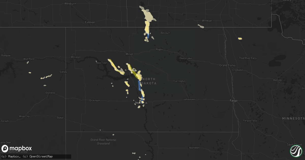
Hail Map in North Dakota on August 23, 2022
Get this storm
August 23 map
$229
one time, instant access
Download today. No call, no setup
Keep the $229
Bought the map and want the full workflow? Apply the entire $229 to a subscription within 7 days. None of it is wasted.
Every map, not just this one
This buys you this map. Subscription and you get every map we run, in the markets you choose from a few cities to whole states to nationwide. Plus real-time alerts the moment a storm fires.
Contact data
Name, contact info, occupancy, even credit band for addresses in the footprint. You go from where it hit to who to call.
Become the source they trust
Unlimited branding weather history reports on demand. You already have the documented answer ready for the property owner, and you are the one who showed up with it.
Property data and RoofTrace estimates
Pull up any address you have got, its value and the exact code rules for that jurisdiction, straight from One Click Code. Then RoofTrace estimates the squares, pitch, and roof value, priced the way you price.
Storm reports in North Dakota
North Dakota
| Date | Description |
|---|---|
| 08/23/20226:25 PM CDT | Pea sized hail and 1.60 inches of rain. |
| 08/23/20226:10 PM CDT | Pea size hail and 0.68 inch of rain. |
| 08/23/20226:10 PM CDT | Pea s |
| 08/23/20226:00 PM CDT | Hail lasted from 600 pm until 605 pm. |
| 08/23/20225:55 PM CDT | Hail lasted from 555 pm until 605 pm. Largest hail lasted only a few minutes with around 1.00 inch of rain. |
| 08/23/20225:33 PM CDT | Hail ongoing at the time of the call. |
| 08/23/20225:20 PM CDT | Minimal crop damage... Dime size hail... And 1.80 inches of rain. Arb observer. |
| 08/23/20225:18 PM CDT | Time estimated from radar. |
| 08/23/20224:40 PM CDT | Time estimated based on radar. Crop damage. |
| 08/23/20224:25 PM CDT | Corrects previous hail report from max. Various sizes of hail with the biggest at quarter size. Heavy rain. Did not measure it yet. |
| 08/23/20224:16 PM CDT | Ndawn station 10 s plaza. |
| 08/23/20224:15 PM CDT | Various sizes of hail with the biggest at quarter size. Heavy rain. Did not measure it yet. |
| 08/23/20224:05 PM CDT | Extensive crop damage from just east of parshall... Mountrail county... To the southeast to near roseglen... Mclean county. This is about an 18 mile long swath. Damage |
| 08/23/20222:34 AM CDT | At 733 PM CDT, a severe thunderstorm was located over Lincoln, or 7 miles southeast of Bismarck, moving south at 45 mph. HAZARD...60 mph wind gusts and quarter size hail. SOURCE...Radar indicated. IMPACT...Hail damage to vehicles is expected. Expect wind damage to roofs, siding, and trees. This severe thunderstorm will impact the following locations... Hazelton Recreation Area, Fort Rice, Temvik, Beaver Bay Recreation Area and Huff. |
| 08/23/202212:58 AM CDT | At 558 PM CDT, a severe thunderstorm was located near Stanton, or 13 miles west of Washburn, moving southeast at 25 mph. HAZARD...Ping pong ball size hail and 60 mph wind gusts. SOURCE...Radar indicated. IMPACT...People and animals outdoors will be injured. Expect hail damage to roofs, siding, windows, and vehicles. Expect wind damage to roofs, siding, and trees. This severe thunderstorm will remain over mainly rural areas of south central McLean and east central Mercer Counties. |
| 08/23/202212:54 AM CDT | At 553 PM CDT, a severe thunderstorm was located near Wilton, or 10 miles southeast of Washburn, moving southeast at 25 mph. HAZARD...70 mph wind gusts and quarter size hail. SOURCE...Radar indicated. IMPACT...Hail damage to vehicles is expected. Expect considerable tree damage. Wind damage is also likely to mobile homes, roofs, and outbuildings. This severe thunderstorm will be near... Wilton around 605 PM CDT.Other locations impacted by this severe thunderstorm include DoubleDitch Indian Village, Price, Baldwin, Sanger, Hensler, Fort Clark andNelson Lake. |
| 08/23/202212:36 AM CDT | At 535 PM CDT, a severe thunderstorm was located 8 miles northeast of Souris, or 9 miles north of Bottineau, moving southeast at 30 mph. HAZARD...60 mph wind gusts and half dollar size hail. SOURCE...Radar indicated. IMPACT...Hail damage to vehicles is expected. Expect wind damage to roofs, siding, and trees. This severe thunderstorm will be near... Bottineau around 555 PM CDT. Willow City around 625 PM CDT.Other locations impacted by this severe thunderstorm include Omemee,Gardena, Carbury and Overly. |
| 08/23/202212:15 AM CDT | At 513 PM CDT, a cluster of severe thunderstorms was centered 5 miles north of Turtle Lake, or 22 miles north of Washburn, moving southeast at 15 mph. HAZARD...Quarter size hail. SOURCE...Radar indicated. IMPACT...Damage to vehicles is expected. This severe thunderstorm will be near... Turtle Lake around 530 PM CDT. Mercer around 600 PM CDT. |
| 08/22/202211:22 PM CDT | At 422 PM CDT, a severe thunderstorm was located over Max, or 12 miles northeast of Garrison, moving southeast at 25 mph. HAZARD...60 mph wind gusts and quarter size hail. SOURCE...Radar indicated. IMPACT...Hail damage to vehicles is expected. Expect wind damage to roofs, siding, and trees. This severe thunderstorm will remain over mainly rural areas of south central Ward and northeastern McLean Counties. |
| 08/22/202211:21 PM CDT | At 421 PM CDT, a severe thunderstorm was located 7 miles northwest of Roseglen, or 26 miles northwest of Garrison, moving southeast at 25 mph. HAZARD...Ping pong ball size hail and 60 mph wind gusts. SOURCE...Radar indicated. IMPACT...People and animals outdoors will be injured. Expect hail damage to roofs, siding, windows, and vehicles. Expect wind damage to roofs, siding, and trees. This severe thunderstorm will be near... Roseglen around 440 PM CDT.Other locations impacted by this severe thunderstorm include WhiteShield and Emmet. |
| 08/22/202210:54 PM CDT | At 354 PM CDT, a severe thunderstorm was located 6 miles north of Max, or 17 miles north of Garrison, moving southeast at 30 mph. HAZARD...Quarter size hail. SOURCE...Radar indicated. IMPACT...Damage to vehicles is expected. This severe thunderstorm will be near... Max around 405 PM CDT. Benedict around 420 PM CDT.Other locations impacted by this severe thunderstorm include Ruso. |
| 08/22/202210:50 PM CDT | At 349 PM CDT, a severe thunderstorm was located near Plaza, or 27 miles southeast of Stanley, moving southeast at 30 mph. HAZARD...Quarter size hail. SOURCE...Radar indicated. IMPACT...Damage to vehicles is expected. This severe thunderstorm will be near... Plaza around 355 PM CDT. Makoti around 410 PM CDT. Ryder around 425 PM CDT. |
| 08/22/20227:40 PM CDT | A local report indicates 60 MPH wind near LINCOLN |
All States Impacted by Hail Map on August 23, 2022
Cities Impacted by Hail Map on August 23, 2022
- Eagle Butte, SD
- Murdo, SD
- Draper, SD
- Hamill, SD
- Winner, SD
- Gregory, SD
- Ideal, SD
- Chamberlain, SD
- Lemmon, SD
- New Salem, ND
- Karlstad, MN
- Halma, MN
- Bismarck, ND
- Mandan, ND
- Ballston Spa, NY
- Freeman, SD
- Hettinger, ND
- Richey, MT
- Kingman, AZ
- Browning, MT
- Lance Creek, WY
- Skull Valley, AZ
- Atkinson, NE
- Naper, NE
- New Town, ND
- Roll, AZ
- Prescott, AZ
- Congress, AZ
- Payson, AZ
- Walhalla, ND
- Langdon, ND
- Bagdad, AZ
- Garrison, MT
- Avon, MT
- Willow City, ND
- Bouse, AZ
- Salome, AZ
- Scottsdale, AZ
- Stanton, ND
- Center, ND
- Bloomfield, MT
- Glendive, MT
- Circle, MT
- Cottonwood, AZ
- Phoenix, AZ
- Glendale, AZ
- Bottineau, ND
- Souris, ND
- Turtle Lake, ND
- Ruso, ND
- Mercer, ND
- Vail, AZ
- Washburn, ND
- Underwood, ND
- Hazen, ND
- Golden Valley, ND
- Timber Lake, SD
- Wilton, ND
- Wolf Point, MT
- Kirkland, AZ
- Baldwin, ND
- Tucson, AZ
- Yucca, AZ
- Max, ND
- Douglas, ND
- Minot, ND
- Gordon, NE
- Rushville, NE
- Buckeye, AZ
- Marana, AZ
- Kilgore, NE
- Mayer, AZ
- Middlebury, CT
- Woodbury, CT
- Southbury, CT
- Naugatuck, CT
- Sahuarita, AZ
- Saint Anthony, ND
- Red Rock, AZ
- Benedict, ND
- Kramer, ND
- Bantry, ND
- Plaza, ND
- Ryder, ND
- Roseglen, ND
- Parshall, ND
- Towner, ND
- Riverdale, ND
- Oxford, CT
- Beacon Falls, CT
- Seymour, CT
- Seligman, AZ
- Valentine, NE
- Garrison, ND
- Makoti, ND
- Crookston, NE
- Valier, MT
- Crown King, AZ
- Apache Junction, AZ
- Superior, AZ
- Bethany, CT
- Butte, NE
- Stickney, SD
- White Lake, SD
- Punta Gorda, FL
- Wittmann, AZ
- Benson, AZ
- Coleharbor, ND
- Olivet, SD
- Grassy Butte, ND


