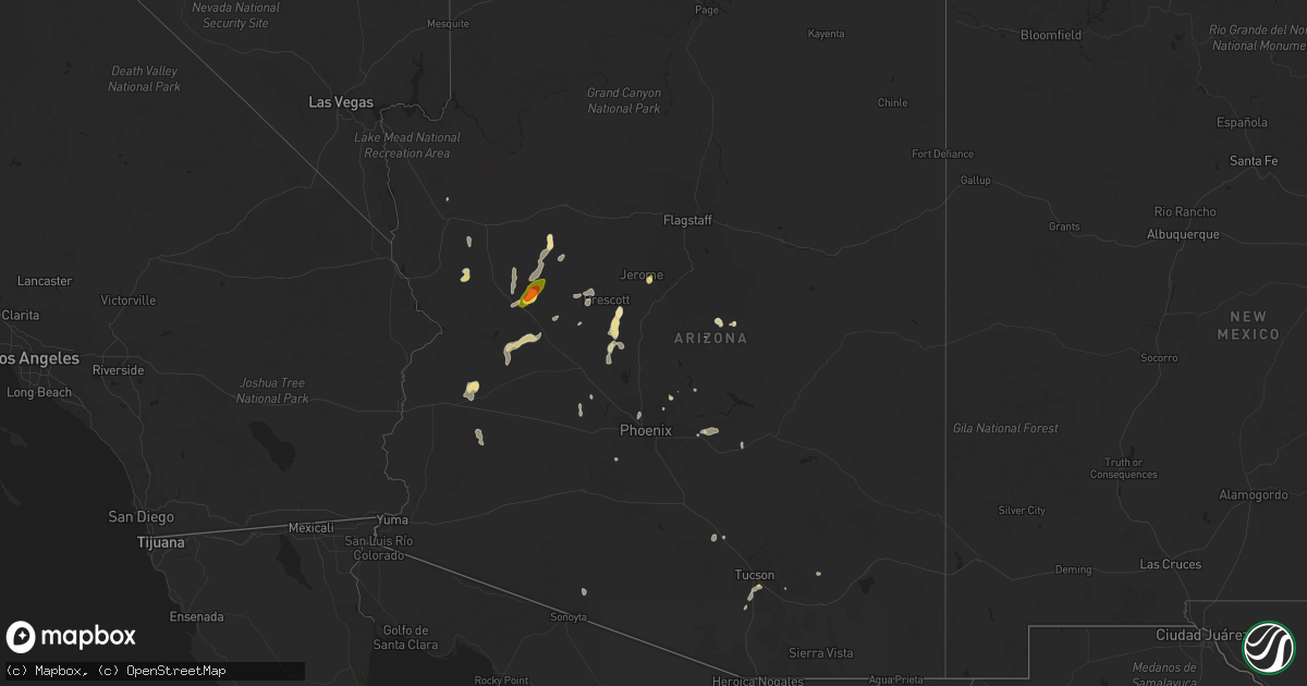
Hail Map in Arizona on August 23, 2022
Get this storm
August 23 map
$229
one time, instant access
Download today. No call, no setup
Keep the $229
Bought the map and want the full workflow? Apply the entire $229 to a subscription within 7 days. None of it is wasted.
Every map, not just this one
This buys you this map. Subscription and you get every map we run, in the markets you choose from a few cities to whole states to nationwide. Plus real-time alerts the moment a storm fires.
Contact data
Name, contact info, occupancy, even credit band for addresses in the footprint. You go from where it hit to who to call.
Become the source they trust
Unlimited branding weather history reports on demand. You already have the documented answer ready for the property owner, and you are the one who showed up with it.
Property data and RoofTrace estimates
Pull up any address you have got, its value and the exact code rules for that jurisdiction, straight from One Click Code. Then RoofTrace estimates the squares, pitch, and roof value, priced the way you price.
Storm reports in Arizona
Arizona
| Date | Description |
|---|---|
| 08/23/20226:54 PM CDT | Public reports quarter size hail. Size ranged from quarter to penny. |
| 08/23/20226:16 PM CDT | Downed power poles and debris in road. |
| 08/23/20225:55 PM CDT | Debris and downed power poles in road. |
| 08/23/20225:40 PM CDT | Corrects previous hail report from 1 nne cottonwood. Public reports quarter size hail. Size ranged from quarter to penny. |
| 08/23/20225:30 PM CDT | Trained weather spotter reported a 61 mph thunderstorm wind gust measured using his davis weather station as well as pea size hail and torrential rainfall. |
| 08/23/20225:30 PM CDT | Public report of 1.00 inch... Quarter size hail. |
| 08/23/20227:53 AM CDT | At 1253 PM MST, a severe thunderstorm was located over Freedom Acres, or near Payson, moving southwest at 10 mph. HAZARD...60 mph wind gusts and quarter size hail. SOURCE...Radar indicated. IMPACT...Hail damage to vehicles is expected. Expect wind damage to roofs, siding, and trees. Locations impacted include... Payson, Star Valley, Oxbow Estates, Round Valley, Flowing Springs, Mesa Del Caballo, Geronimo Estates, Freedom Acres, Pine, East Verde Estates, Whispering Pines, Geronimo Boy Scout Camp, Houston Mesa Campground, Water Wheel Burn At Houston Mesa Rd- S, Tonto Natural Bridge State Park, Beaver Valley, Water Wheel Burn At Houston Mesa Rd-N and Kehl Springs Campground. |
| 08/23/20223:33 AM CDT | At 833 PM MST, severe thunderstorms were located along a line extending from 12 miles southwest of Quartzsite to 11 miles southwest of Kofa Wildlife Refuge to 23 miles west of Sundad, moving southwest at 20 mph. HAZARD...60 mph wind gusts. SOURCE...Radar indicated. IMPACT...Expect damage to roofs, siding, and trees. Locations impacted include... Yuma Proving Ground, Cibola and Palm Canyon. This includes the following highways...AZ Interstate 10 between mile markers 8 and 9.AZ Route 95 between mile markers 59 and 92. |
| 08/23/20223:14 AM CDT | At 814 PM MST, a severe thunderstorm was located 15 miles east of Kofa Wildlife Refuge, or 48 miles west of Tonopah, moving west at 10 mph. HAZARD...60 mph wind gusts and quarter size hail. SOURCE...Radar indicated. IMPACT...Hail damage to vehicles is expected. Expect wind damage to roofs, siding, and trees. This severe thunderstorm will remain over mainly rural areas of east central La Paz and northern Yuma Counties. |
| 08/23/20222:37 AM CDT | At 737 PM MST, a severe thunderstorm was located 7 miles south of Saguaro National Park East, or 16 miles east of Davis-Monthan Air Force Base, moving southeast at 10 mph. HAZARD...60 mph wind gusts and penny size hail. SOURCE...Radar indicated. IMPACT...Expect damage to roofs, siding, and trees. Locations impacted include... Tucson, Vail and Saguaro National Park East. |
| 08/23/20222:25 AM CDT | At 725 PM MST, a severe thunderstorm was located near Brenda, or 39 miles southeast of Parker, moving west at 5 mph. HAZARD...70 mph wind gusts and ping pong ball size hail. SOURCE...Radar indicated. IMPACT...People and animals outdoors will be injured. Expect hail damage to roofs, siding, windows, and vehicles. Expect considerable tree damage. Wind damage is also likely to mobile homes, roofs, and outbuildings. Locations impacted include... Quartzsite, Kofa Wildlife Refuge and Brenda. This includes the following highways...AZ Interstate 10 between mile markers 14 and 46.US Highway 60 between mile markers 31 and 41.AZ Route 95 between mile markers 99 and 111. |
| 08/23/20222:12 AM CDT | At 712 PM MST, a severe thunderstorm was located near Summit, or near Sahuarita, moving south at 10 mph. HAZARD...60 mph wind gusts and penny size hail. SOURCE...Radar indicated. IMPACT...Expect damage to roofs, siding, and trees. Locations impacted include... Sahuarita, Green Valley, Drexel Heights, Pascua Pueblo Yaqui Reservation, East Sahuarita, Tucson International Airport, Summit, Valencia West and San Xavier Mission. |
| 08/23/20222:07 AM CDT | At 706 PM MST, a cluster of severe thunderstorms was located 16 miles south of Gila Bend Auxiliary Field, or 20 miles south of Gila Bend, and is nearly stationary. HAZARD...60 mph wind gusts and quarter size hail. SOURCE...Radar indicated. IMPACT...Hail damage to vehicles is expected. Expect wind damage to roofs, siding, and trees. This severe thunderstorm will remain over mainly rural areas of Maricopa County.This includes AZ Route 85 between mile markers 14 and 31. |
| 08/23/20221:57 AM CDT | At 656 PM MST, a severe thunderstorm was located 9 miles east of Bouse, or 30 miles southwest of Alamo Lake, moving southwest at 5 mph. HAZARD...60 mph wind gusts and quarter size hail. SOURCE...Radar indicated. IMPACT...Hail damage to vehicles is expected. Expect wind damage to roofs, siding, and trees. Locations impacted include... Bouse, Vicksburg and Vicksburg Junction. This includes the following highways...US Highway 60 between mile markers 39 and 49.AZ Route 72 between mile markers 26 and 49. |
| 08/23/20221:32 AM CDT | At 632 PM MST, a severe thunderstorm was located over Tucson International Airport, or 7 miles southwest of Tucson, moving southwest at 15 mph. HAZARD...60 mph wind gusts. SOURCE...Radar indicated. IMPACT...Expect damage to roofs, siding, and trees. Locations impacted include... Tucson, Drexel Heights, South Tucson, Pascua Pueblo Yaqui Reservation, Tucson International Airport, Summit, Valencia West and San Xavier Mission. |
| 08/23/20221:29 AM CDT | At 629 PM MST, a severe thunderstorm was located 12 miles north of Wenden, or 19 miles south of Alamo Lake, moving southwest at 30 mph. HAZARD...60 mph wind gusts and quarter size hail. SOURCE...Radar indicated. IMPACT...Hail damage to vehicles is expected. Expect wind damage to roofs, siding, and trees. Locations impacted include... Wenden, Salome and Harcuvar. This includes US Highway 60 between mile markers 54 and 69. |
| 08/23/20221:10 AM CDT | At 610 PM MST, a severe thunderstorm was located 8 miles south of Estrella Mountain Park, or 14 miles south of Avondale, moving south at 5 mph. HAZARD...60 mph wind gusts and quarter size hail. SOURCE...Radar indicated. IMPACT...Hail damage to vehicles is expected. Expect wind damage to roofs, siding, and trees. Locations impacted include... Avondale, Goodyear and Rainbow Valley. |
| 08/23/20221:06 AM CDT | At 605 PM MST, a severe thunderstorm was located 9 miles northwest of Santa Rosa, or 37 miles northwest of Sells, and is nearly stationary. HAZARD...60 mph wind gusts and nickel size hail. SOURCE...Radar indicated. IMPACT...Expect damage to roofs, siding, and trees. Locations impacted include... Ventana and Santa Rosa School. |
| 08/23/202212:58 AM CDT | At 558 PM MST, severe thunderstorms were located along a line extending from 9 miles east of Aguila to 10 miles southwest of Morristown to 10 miles west of White Tank Mountain Park, moving southwest at 10 mph. HAZARD...60 mph wind gusts and quarter size hail. SOURCE...Radar indicated. IMPACT...Hail damage to vehicles is expected. Expect wind damage to roofs, siding, and trees. Locations impacted include... Surprise, Buckeye, Wittmann, Circle City and Morristown. This includes the following highways...AZ Interstate 10 between mile markers 96 and 109.US Highway 60 between mile markers 85 and 103, and between milemarkers 117 and 132.AZ Route 74 between mile markers 1 and 9. |
| 08/23/202212:54 AM CDT | At 554 PM MST, a severe thunderstorm was located near Bosque, or 9 miles northeast of Gila Bend, and is nearly stationary. HAZARD...60 mph wind gusts. SOURCE...Radar indicated. IMPACT...Expect damage to roofs, siding, and trees. Locations impacted include... Gila Bend, Estrella, Bosque, Cotton Center and Sonoran National Monument.This includes the following highways...AZ Interstate 8 between mile markers 115 and 121.AZ Route 238 between mile markers 1 and 19.AZ Route 85 between mile markers 1 and 2, and between mile markers119 and 136. |
| 08/23/202212:47 AM CDT | At 547 PM MST, a severe thunderstorm was located over Davis-Monthan Air Force Base, moving west at 10 mph. HAZARD...60 mph wind gusts and penny size hail. SOURCE...Radar indicated. IMPACT...Expect damage to roofs, siding, and trees. Locations impacted include... Tucson, Davis-Monthan Air Force Base, Tanque Verde, Tucson International Airport, Catalina Foothills and Saguaro National Park East. |
| 08/23/202212:47 AM CDT | At 547 PM MST, a severe thunderstorm was located 15 miles east of Alamo State Park, or 16 miles east of Alamo Lake, moving southwest at 15 mph. HAZARD...60 mph wind gusts and quarter size hail. SOURCE...Radar indicated. IMPACT...Hail damage to vehicles is expected. Expect wind damage to roofs, siding, and trees. This severe thunderstorm will remain over mainly rural areas of northeastern La Paz County. |
| 08/23/202212:36 AM CDT | At 535 PM MST, a severe thunderstorm was located 16 miles east of Alamo State Park, or 17 miles east of Alamo Lake, and is moving to the southwest at 10 mph. stationary. HAZARD...60 mph wind gusts and quarter size hail. SOURCE...Radar indicated. IMPACT...Hail damage to vehicles is expected. Expect wind damage to roofs, siding, and trees. This severe thunderstorm will remain over mainly rural areas of Yavapai County. |
| 08/23/202212:26 AM CDT | At 525 PM MST, a severe thunderstorm was located near Red Rock, or 16 miles northwest of Marana, moving southwest at 10 mph. HAZARD...60 mph wind gusts and quarter size hail. SOURCE...Radar indicated. IMPACT...Hail damage to vehicles is expected. Expect wind damage to roofs, siding, and trees. Locations impacted include... Avra Valley and Red Rock. |
| 08/23/202212:16 AM CDT | At 516 PM MST, severe thunderstorms were located along a line extending from 8 miles northwest of Congress to 7 miles south of Yarnell to 8 miles west of Castle Hot Springs, moving southwest at 25 mph. HAZARD...60 mph wind gusts. SOURCE...Radar indicated. IMPACT...Expect damage to roofs, siding, and trees. Locations impacted include... Surprise, Buckeye, Wickenburg, Wittmann, Circle City, White Tank Mountain Park and Morristown.This includes the following highways...US Highway 60 between mile markers 86 and 135.AZ Route 74 between mile markers 1 and 17. |
| 08/23/202212:10 AM CDT | At 510 PM MST, a severe thunderstorm was located over San Manuel, or 8 miles east of Oracle, moving southwest at 5 mph. HAZARD...60 mph wind gusts and quarter size hail. SOURCE...Radar indicated. IMPACT...Hail damage to vehicles is expected. Expect wind damage to roofs, siding, and trees. Locations impacted include... Oracle, San Manuel and Campo Bonito. |
| 08/23/202212:07 AM CDT | At 506 PM MST, a severe thunderstorm was located near Bagdad, moving southwest at 10 mph. HAZARD...60 mph wind gusts and quarter size hail. SOURCE...Radar indicated. IMPACT...Hail damage to vehicles is expected. Expect wind damage to roofs, siding, and trees. Locations impacted include... Bagdad. |
| 08/22/202211:58 PM CDT | At 457 PM MST, a severe thunderstorm was located over Metro Center, or near Glendale, moving southwest at 10 mph. HAZARD...60 mph wind gusts. SOURCE...Radar indicated. IMPACT...Expect damage to roofs, siding, and trees. Locations impacted include... Phoenix, Glendale, Surprise, Avondale, El Mirage, Tolleson, Youngtown, Sun City, Waddell, Cashion, Litchfield Park, Glendale Sports Complex, Piestewa Peak Park, Luke AFB and North Mountain Park.This includes the following highways...AZ Interstate 10 between mile markers 130 and 141.AZ Interstate 17 between mile markers 202 and 217.AZ Route 51 between mile markers 5 and 8. |
| 08/22/202211:56 PM CDT | At 455 PM MST, a severe thunderstorm was located near Castle Hot Springs, or 13 miles northeast of Circle City, moving south at 25 mph. HAZARD...60 mph wind gusts and quarter size hail. SOURCE...Radar indicated. IMPACT...Hail damage to vehicles is expected. Expect wind damage to roofs, siding, and trees. Locations impacted include... Castle Hot Springs. |
| 08/22/202211:25 PM CDT | At 425 PM MST, a severe thunderstorm was located over Crown King, or 24 miles south of Prescott, moving southwest at 10 mph. HAZARD...60 mph wind gusts and quarter size hail. SOURCE...Radar indicated. IMPACT...Hail damage to vehicles is expected. Expect wind damage to roofs, siding, and trees. Locations impacted include... Wagoner, Crown King, Turney Gulch Group Campground and Hazlett Hollow Campground. |
| 08/22/202211:12 PM CDT | At 412 PM MST, a severe thunderstorm was located near Aravaipa Canyon Wilderness, or 10 miles east of Winkelman, moving southwest at 15 mph. HAZARD...60 mph wind gusts and quarter size hail. SOURCE...Radar indicated. IMPACT...Hail damage to vehicles is expected. Expect wind damage to roofs, siding, and trees. Locations impacted include... Dudleyville, Aravaipa Canyon Wilderness and San Carlos Reservoir. |
| 08/22/202211:09 PM CDT | At 409 PM MST, a severe thunderstorm was located near Scottsdale, moving southwest at 20 mph. HAZARD...60 mph wind gusts and penny size hail. SOURCE...Radar indicated. IMPACT...Expect damage to roofs, siding, and trees. Locations impacted include... Phoenix, Scottsdale, Fountain Hills, Paradise Valley, Carefree, Downtown Scottsdale, McDowell Mountain Park, Scottsdale Airport, Desert Ridge Marketplace and Rio Verde.This includes the following highways...AZ Route 51 between mile markers 11 and 15.AZ Route 101 between mile markers 28 and 47. |
| 08/22/202211:06 PM CDT | At 406 PM MST, a severe thunderstorm was located over Walker, or 10 miles southeast of Prescott, moving southwest at 10 mph. HAZARD...60 mph wind gusts and quarter size hail. SOURCE...Radar indicated. IMPACT...Hail damage to vehicles is expected. Expect wind damage to roofs, siding, and trees. Locations impacted include... Walker, Groom Creek Subdivision, Poland Junction, Lower Wolf Creek Campground and Upper Wolf Creek Group Campground. |
| 08/22/202211:05 PM CDT | At 405 PM MST, a severe thunderstorm was located 26 miles north of Bagdad, or 36 miles west of Chino Valley, moving southwest at 10 mph. HAZARD...60 mph wind gusts and quarter size hail. SOURCE...Radar indicated. IMPACT...Hail damage to vehicles is expected. Expect wind damage to roofs, siding, and trees. Locations impacted include... Mount Hope. |
| 08/22/202210:56 PM CDT | At 356 PM MST, a severe thunderstorm was located over Lost Dutchman State Park, or near Apache Junction, moving west at 10 mph. HAZARD...60 mph wind gusts and quarter size hail. SOURCE...Radar indicated. IMPACT...Hail damage to vehicles is expected. Expect wind damage to roofs, siding, and trees. Locations impacted include... Mesa, Gilbert, Apache Junction, East Mesa, Gold Canyon, Queen Creek, Granite Reef Dam, Gold Camp, Falcon Field Airport, Lost Dutchman State Park, Goldfield, Usery Mountain Park, Superstition Springs Mall, Canyon Lake and Superstition Mountains.This includes the following highways...US Highway 60 between mile markers 186 and 204.AZ Route 87 between mile markers 185 and 187.AZ Route 202 between mile markers 20 and 38. |
| 08/22/202210:52 PM CDT | At 352 PM MST, a severe thunderstorm was located over Walker, or 9 miles south of Prescott Valley, moving southwest at 10 mph. HAZARD...60 mph wind gusts and quarter size hail. SOURCE...Radar indicated. IMPACT...Hail damage to vehicles is expected. Expect wind damage to roofs, siding, and trees. Locations impacted include... Ponderosa Park, Groom Creek Subdivision, Mayer, Walker, Poland Junction, Lower Wolf Creek Campground, Upper Wolf Creek Group Campground and Lynx Lake Dam. |
| 08/22/202210:50 PM CDT | At 350 PM MST, a severe thunderstorm was located 26 miles south of Seligman, or 34 miles northwest of Chino Valley, moving southwest at 10 mph. HAZARD...60 mph wind gusts and quarter size hail. SOURCE...Radar indicated. IMPACT...Hail damage to vehicles is expected. Expect wind damage to roofs, siding, and trees. Locations impacted include... Mount Hope. |
| 08/22/202210:36 PM CDT | At 336 PM MST, a severe thunderstorm was located near Verde Village, or 11 miles northwest of Camp Verde, moving southwest at 10 mph. HAZARD...60 mph wind gusts and half dollar size hail. SOURCE...Radar indicated. IMPACT...Hail damage to vehicles is expected. Expect wind damage to roofs, siding, and trees. Locations impacted include... Clarkdale, Verde Village, Bridgeport, Cherry, Cottonwood, Jerome, Dead Horse Ranch State Park, Powell Springs Campground, Mingus Mountain Campground, Playground Group Campground, Potato Patch Campground and Tuzigoot National Monument. |
| 08/22/202210:32 PM CDT | At 330 PM MST, a severe thunderstorm was located 7 miles east of Blake Ranch Road, or 19 miles east of Kingman, moving south at 10 mph. HAZARD...60 mph wind gusts and quarter size hail. SOURCE...Radar indicated. IMPACT...Hail damage to vehicles is expected. Expect wind damage to roofs and trees. Locations impacted include... The intersection of Interstate 40 and US 93 and the southeast portion of Hualapai Mountain. |
| 08/22/202210:28 PM CDT | At 328 PM MST, severe thunderstorms were located along a line extending from near Superstition Mountains to 7 miles north of Queen Valley to near Superior, moving southwest at 5 mph. HAZARD...60 mph wind gusts and quarter size hail. SOURCE...Radar indicated. IMPACT...Hail damage to vehicles is expected. Expect wind damage to roofs, siding, and trees. Locations impacted include... Mesa, Apache Junction, Superior, Gold Canyon, Top Of The World, Gold Camp, Lost Dutchman State Park, Goldfield, Usery Mountain Park, Top-Of-The-World, Florence Junction, Queen Valley, Canyon Lake, Superstition Mountains and Kings Ranch.This includes the following highways...US Highway 60 between mile markers 194 and 235.AZ Route 202 between mile markers 24 and 28.AZ Route 79 between mile markers 147 and 150. |
| 08/22/202210:21 PM CDT | At 321 PM MST, severe thunderstorms were located along a line extending from near Round Valley to Sugarloaf Mountain to near Saguaro Lake, moving west at 15 mph. HAZARD...60 mph wind gusts and quarter size hail. SOURCE...Radar indicated. IMPACT...Hail damage to vehicles is expected. Expect wind damage to roofs, siding, and trees. Locations impacted include... Mesa, Scottsdale, Fountain Hills, Sugarloaf Mountain, Ballantine Trailhead, Granite Reef Dam, McDowell Mountain Park, Usery Mountain Park, Saguaro Lake, Canyon Lake, Goldfield Ranch, Desert Mountain, Camp Creek, Salt River Tubing Recreation Area and Rio Verde.This includes the following highways...AZ Route 87 between mile markers 186 and 211.AZ Route 202 between mile markers 23 and 25. |
| 08/22/202210:17 PM CDT | At 317 PM MST, a severe thunderstorm was located over Verde Village, or 10 miles northwest of Camp Verde, moving southwest at 10 mph. HAZARD...60 mph wind gusts and half dollar size hail. SOURCE...Radar indicated. IMPACT...Hail damage to vehicles is expected. Expect wind damage to roofs, siding, and trees. Locations impacted include... Clarkdale, Verde Village, Bridgeport, Cherry, Cottonwood, Jerome, Dead Horse Ranch State Park, Powell Springs Campground, Mingus Mountain Campground, Playground Group Campground, Potato Patch Campground and Tuzigoot National Monument. |
| 08/22/202210:15 PM CDT | At 314 PM MST, a severe thunderstorm was located near Iron Springs, or 9 miles northwest of Prescott, moving southwest at 10 mph. HAZARD...60 mph wind gusts and quarter size hail. SOURCE...Radar indicated. IMPACT...Hail damage to vehicles is expected. Expect wind damage to roofs, siding, and trees. Locations impacted include... Prescott, Yavapai Campground and Iron Springs. |
| 08/22/202210:12 PM CDT | At 312 PM MST, a severe thunderstorm was located near Camp Creek, or 14 miles east of New River, moving southwest at 10 mph. HAZARD...60 mph wind gusts. SOURCE...Radar indicated. IMPACT...Expect damage to roofs, siding, and trees. Locations impacted include... New River, Cave Creek, Camp Creek, Seven Springs and Anthem. This includes AZ Interstate 17 between mile markers 227 and 241. |
| 08/22/202210:09 PM CDT | At 309 PM MST, a severe thunderstorm was located 11 miles northwest of Horseshoe Reservoir, or 17 miles northeast of New River, moving southwest at 10 mph. HAZARD...60 mph wind gusts and half dollar size hail. SOURCE...Radar indicated. IMPACT...Hail damage to vehicles is expected. Expect wind damage to roofs, siding, and trees. Locations impacted include... Rock Springs and Black Canyon City. |
| 08/22/20229:48 PM CDT | Rta pima county website reports that multiple powerlines are down due to wind damage yesterday and causing road closure. Also reported on social media. |
| 08/22/20229:36 PM CDT | At 235 PM MST, a severe thunderstorm was located over Sycamore Creek, moving southwest at 10 mph. HAZARD...60 mph wind gusts and quarter size hail. SOURCE...Radar indicated. IMPACT...Hail damage to vehicles is expected. Expect wind damage to roofs, siding, and trees. Locations impacted include... Round Valley, Sycamore Creek, Sunflower and Ballantine Trailhead. This includes AZ Route 87 between mile markers 210 and 229. |
| 08/22/20228:34 PM CDT | Wind gust was measured at the tucson international airport. |
| 08/22/20228:24 PM CDT | At 124 PM MST, a severe thunderstorm was located over East Verde Estates, or over Payson, moving southwest at 15 mph. HAZARD...60 mph wind gusts and quarter size hail. SOURCE...Radar indicated. IMPACT...Hail damage to vehicles is expected. Expect wind damage to roofs, siding, and trees. Locations impacted include... Payson, Star Valley, Oxbow Estates, Round Valley, Flowing Springs, East Verde Estates, Mesa Del Caballo and Houston Mesa Campground. |
| 08/22/20228:15 PM CDT | Social media report of multiple power poles down on kolb between golf links and escalante. |
| 08/22/20227:10 PM CDT | Social media picture showed a very large tree uprooted that fell in between two residential complexes and destroyed a fence. |
| 08/22/20227:10 PM CDT | Social media report of golf ball size hail near bagdad. |
All States Impacted by Hail Map on August 23, 2022
Cities Impacted by Hail Map on August 23, 2022
- Eagle Butte, SD
- Murdo, SD
- Draper, SD
- Hamill, SD
- Winner, SD
- Gregory, SD
- Ideal, SD
- Chamberlain, SD
- Lemmon, SD
- New Salem, ND
- Karlstad, MN
- Halma, MN
- Bismarck, ND
- Mandan, ND
- Ballston Spa, NY
- Freeman, SD
- Hettinger, ND
- Richey, MT
- Kingman, AZ
- Browning, MT
- Lance Creek, WY
- Skull Valley, AZ
- Atkinson, NE
- Naper, NE
- New Town, ND
- Roll, AZ
- Prescott, AZ
- Congress, AZ
- Payson, AZ
- Walhalla, ND
- Langdon, ND
- Bagdad, AZ
- Garrison, MT
- Avon, MT
- Willow City, ND
- Bouse, AZ
- Salome, AZ
- Scottsdale, AZ
- Stanton, ND
- Center, ND
- Bloomfield, MT
- Glendive, MT
- Circle, MT
- Cottonwood, AZ
- Phoenix, AZ
- Glendale, AZ
- Bottineau, ND
- Souris, ND
- Turtle Lake, ND
- Ruso, ND
- Mercer, ND
- Vail, AZ
- Washburn, ND
- Underwood, ND
- Hazen, ND
- Golden Valley, ND
- Timber Lake, SD
- Wilton, ND
- Wolf Point, MT
- Kirkland, AZ
- Baldwin, ND
- Tucson, AZ
- Yucca, AZ
- Max, ND
- Douglas, ND
- Minot, ND
- Gordon, NE
- Rushville, NE
- Buckeye, AZ
- Marana, AZ
- Kilgore, NE
- Mayer, AZ
- Middlebury, CT
- Woodbury, CT
- Southbury, CT
- Naugatuck, CT
- Sahuarita, AZ
- Saint Anthony, ND
- Red Rock, AZ
- Benedict, ND
- Kramer, ND
- Bantry, ND
- Plaza, ND
- Ryder, ND
- Roseglen, ND
- Parshall, ND
- Towner, ND
- Riverdale, ND
- Oxford, CT
- Beacon Falls, CT
- Seymour, CT
- Seligman, AZ
- Valentine, NE
- Garrison, ND
- Makoti, ND
- Crookston, NE
- Valier, MT
- Crown King, AZ
- Apache Junction, AZ
- Superior, AZ
- Bethany, CT
- Butte, NE
- Stickney, SD
- White Lake, SD
- Punta Gorda, FL
- Wittmann, AZ
- Benson, AZ
- Coleharbor, ND
- Olivet, SD
- Grassy Butte, ND


