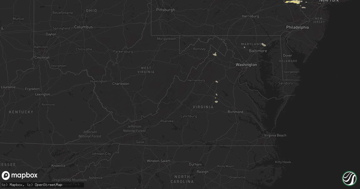
Hail Map in Virginia on August 22, 2022
Get this storm
August 22 map
$229
one time, instant access
Download today. No call, no setup
Keep the $229
Bought the map and want the full workflow? Apply the entire $229 to a subscription within 7 days. None of it is wasted.
Every map, not just this one
This buys you this map. Subscription and you get every map we run, in the markets you choose from a few cities to whole states to nationwide. Plus real-time alerts the moment a storm fires.
Contact data
Name, contact info, occupancy, even credit band for addresses in the footprint. You go from where it hit to who to call.
Become the source they trust
Unlimited branding weather history reports on demand. You already have the documented answer ready for the property owner, and you are the one who showed up with it.
Property data and RoofTrace estimates
Pull up any address you have got, its value and the exact code rules for that jurisdiction, straight from One Click Code. Then RoofTrace estimates the squares, pitch, and roof value, priced the way you price.
Storm reports in Virginia
Virginia
| Date | Description |
|---|---|
| 08/22/20226:55 PM CDT | The right lane and right shoulder are closed on i-64 near mm 166 in goochland county due to weather. Time estimated from radar data. |
| 08/22/20226:45 PM CDT | Tree down on route 250 in the vicinity of old fredericksburg road. Time estimated from radar data. |
| 08/22/20226:30 PM CDT | Power lines down. Time estimated from radar data. |
| 08/22/20224:39 PM CDT | Tree down blocking roadway near the intersection of waterford road and korea road. |
| 08/22/20224:28 PM CDT | Trees blew down in the 9400 block of us-15 james madison highway... Including a large pine tree that blocked all travel lanes. |
| 08/22/20223:49 PM CDT | Tree down on front royal pike near bufflick road. |
| 08/22/20222:11 AM CDT | At 710 PM EDT, severe thunderstorms were located along a line extending from Louisa to near Ferncliff to near Palmyra, moving southeast at 20 mph. HAZARD...60 mph wind gusts. SOURCE...Radar indicated. IMPACT...Expect damage to trees and powerlines. Severe thunderstorms will be near... Mineral around 725 PM EDT. Hadensville and Columbia around 730 PM EDT. Fife around 745 PM EDT. Gum Spring around 750 PM EDT. Goochland around 800 PM EDT.Other locations impacted by these severe thunderstorms includeOrchid, Dixie, Pendleton, Sandy Hook, Louisa Airport, Rock Castle,Stage Junction, Three Square, Irwin and Cuckoo. |
| 08/22/202212:21 AM CDT | At 521 PM EDT, a severe thunderstorm was located 7 miles west of Culpeper, moving southeast at 15 mph. HAZARD...60 mph wind gusts and quarter size hail. SOURCE...Radar indicated. IMPACT...Damaging winds will cause some trees and large branches to fall. This could injure those outdoors, as well as damage homes and vehicles. Roadways may become blocked by downed trees. Localized power outages are possible. Unsecured light objects may become projectiles. Locations impacted include... Culpeper, Madison, Brightwood, Raccoon Ford, Catalpa, Stevensburg, Rhoadesville, Rapidan, Oakpark, Everona, Verdiersville, Burr Hill, Pratts, Winston, Lignum, Mitchells, Reva, Fordsville, Twymans Mill and Leon. |
All States Impacted by Hail Map on August 22, 2022
Cities Impacted by Hail Map on August 22, 2022
- Annandale, NJ
- Lebanon, NJ
- Selfridge, ND
- Peridot, AZ
- Benson, AZ
- Coplay, PA
- Allentown, PA
- Whitehall, PA
- Ketchum, ID
- Saint George, UT
- Washington, UT
- Columbia, VA
- Palmyra, VA
- Kents Store, VA
- Catasauqua, PA
- Northampton, PA
- Milford, NJ
- Bloomsbury, NJ
- Bath, PA
- Hellertown, PA
- Phillipsburg, NJ
- Orefield, PA
- Easton, PA
- Stewartsville, NJ
- Bethlehem, PA
- Schnecksville, PA
- Asbury, NJ
- Nazareth, PA
- Naples, FL
- Winchester, VA
- Immokalee, FL
- Germansville, PA
- Culpeper, VA
- Rapidan, VA
- Brightwood, VA
- Kingsville, MD
- Upper Falls, MD
- Joppa, MD
- Augusta, MT
- Hilton Head Island, SC
- Fork, MD
- Baldwin, MD
- Glen Arm, MD
- Edgewood, MD
- Hydes, MD
- Fallston, MD
- Woodbine, MD
- Mount Airy, MD
- Snowville, UT
- Bluffton, SC
- Scotch Plains, NJ
- Plainfield, NJ
- Clark, NJ
- Comstock, TX
- Clear Brook, VA
- Mason, TX
- Heart Butte, MT
- Gordonsville, VA
- Louisa, VA
- Flemington, NJ
- Frenchtown, NJ
- Pittstown, NJ
- Troy, VA
- Hampton, NJ
- Winona, TX


