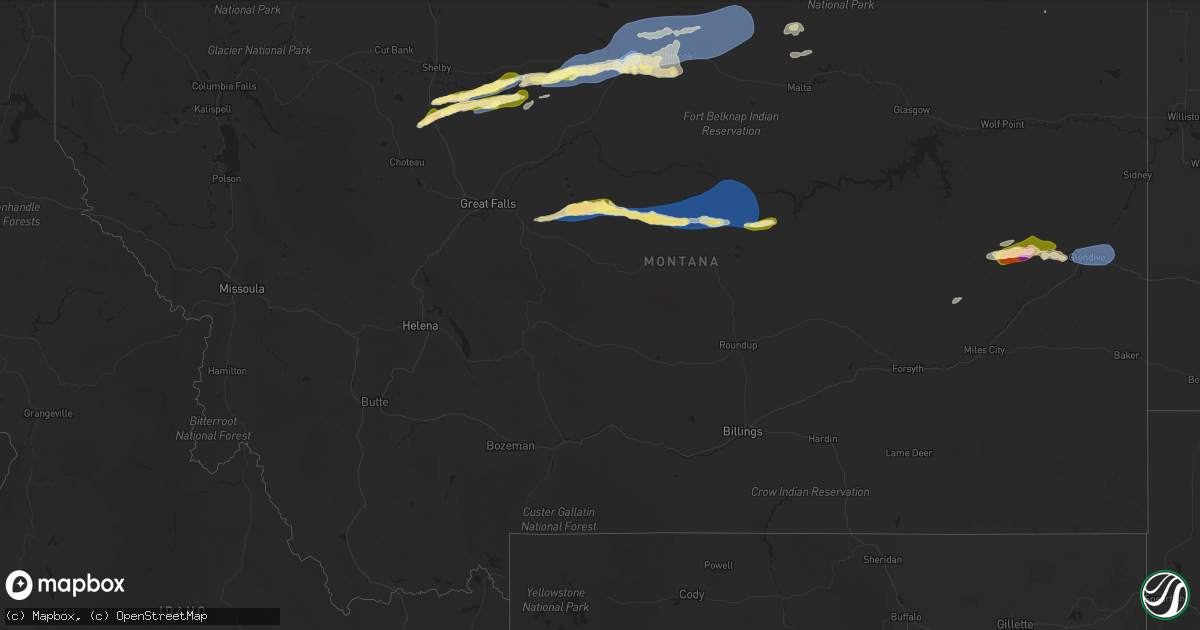
Hail Map in Montana on August 20, 2025
Get this storm
August 20 map
$229
one time, instant access
Download today. No call, no setup
Keep the $229
Bought the map and want the full workflow? Apply the entire $229 to a subscription within 7 days. None of it is wasted.
Every map, not just this one
This buys you this map. Subscription and you get every map we run, in the markets you choose from a few cities to whole states to nationwide. Plus real-time alerts the moment a storm fires.
Contact data
Name, contact info, occupancy, even credit band for addresses in the footprint. You go from where it hit to who to call.
Become the source they trust
Unlimited branding weather history reports on demand. You already have the documented answer ready for the property owner, and you are the one who showed up with it.
Property data and RoofTrace estimates
Pull up any address you have got, its value and the exact code rules for that jurisdiction, straight from One Click Code. Then RoofTrace estimates the squares, pitch, and roof value, priced the way you price.
Storm reports in Montana
Montana
| Date | Description |
|---|---|
| 08/20/20256:55 PM CDT | Corrects previous non-tstm wnd gst report from 8 ene denton. Awos station k1dm 7 ene denton. |
| 08/20/20256:54 PM CDT | Peak wind gust measured by ambient station pg ranch. |
| 08/20/20256:38 PM CDT | Social media picture of hail approximated to be 1.25 inches or a bit larger 1 mile south of havre. Time estimated using radar. |
| 08/20/20256:35 PM CDT | A local report indicates 75 MPH wind near 4 W Havre |
| 08/20/20256:30 PM CDT | A local report indicates 63 MPH wind near 7 SW Havre |
| 08/20/20256:29 PM CDT | A local report indicates 58 MPH wind near 4 W Havre |
| 08/20/20255:30 PM CDT | Mesonet station gw4079 inverness ten south southeas. |
| 08/20/20254:25 PM CDT | Bootlegger s cg sw mesonet. |
| 08/20/20255:32 AM CDT | Awos station kgdv glendive airport. |
| 08/20/20254:53 AM CDT | Winds knocked down tree limbs. It is estimated that gusts of 50 to 60 mph occurred. |
| 08/20/20254:53 AM CDT | Wind also accompanied the storm... Knocking tree limbs down. |
| 08/19/20258:20 PM CDT | Montana mesonet station roy e. Sustained winds of 44 mph at time of report. |
| 08/19/20258:20 PM CDT | Montana mesonet station |
All States Impacted by Hail Map on August 20, 2025
Cities Impacted by Hail Map on August 20, 2025
- Camden, MS
- Kosciusko, MS
- Canton, MS
- Dayton, TN
- Carthage, TX
- Crossville, TN
- Altha, FL
- Marianna, FL
- Grandview, TN
- Ethel, MS
- Huntsville, AL
- Mertzon, TX
- Harriman, TN
- Garrison, TX
- Nacogdoches, TX
- Morrison, TN
- Mcminnville, TN
- Georgetown, TN
- Birchwood, TN
- Harrison, TN
- Old Fort, NC
- Ringgold, LA
- West Point, MS
- Cleveland, TN
- Signal Mountain, TN
- Hamilton, MS
- Prairie, MS
- Utica, MS
- Raymond, MS
- Fort Rucker, AL
- Ozark, AL
- Duck Hill, MS
- Grenada, MS
- Berry, AL
- Northport, AL
- Aberdeen, MS
- Belvidere, TN
- Winchester, TN
- Pickens, SC
- Conrad, MT
- Detroit, AL
- Sulligent, AL
- Greenwood Springs, MS
- Ledger, MT
- Quincy, FL
- Attapulgus, GA
- Greenwood, MS
- Havana, FL
- Elm Grove, LA
- Sherwood, TN
- Choteau, MT
- El Dorado, AR
- Gattman, MS
- Caledonia, MS
- Galata, MT
- Chester, MT
- Vaiden, MS
- Hazlehurst, MS
- Grand Cane, LA
- Frierson, LA
- Imperial, TX
- Gloster, LA
- Union Church, MS
- Eldorado, TX
- Livingston, TX
- Cleveland, TX
- Hermitage, AR
- Highland Home, AL
- Luverne, AL
- Honoraville, AL
- Leesburg, AL
- Warren, AR
- Joplin, MT
- Jamestown, TN
- Allardt, TN
- Spring Hill, TN
- Columbia, TN
- Inverness, MT
- Cedar Bluff, AL
- Rudyard, MT
- Hingham, MT
- Paoli, OK
- Muscle Shoals, AL
- Gildford, MT
- Rayville, LA
- Tuscumbia, AL
- Maysville, OK
- Belt, MT
- Pauls Valley, OK
- Geyser, MT
- Hayneville, AL
- Lowndesboro, AL
- Kremlin, MT
- Box Elder, MT
- Baskin, LA
- Highwood, MT
- Raynesford, MT
- Rattan, OK
- Havre, MT
- Geraldine, MT
- Coffee Creek, MT
- Georgetown, LA
- Hugo, OK
- Jacksonville, AL
- Wellington, AL
- Alexandria, AL
- Denton, MT
- Winnsboro, LA
- Monticello, AR
- Anniston, AL
- Lineville, AL
- Chinook, MT
- Soper, OK
- Jones, LA
- Lewistown, MT
- Hilger, MT
- Marion, AL
- Bonita, LA
- Atlanta, GA
- Mer Rouge, LA
- Harlem, MT
- Zurich, MT
- Hogeland, MT
- Roy, MT
- Winifred, MT
- Turner, MT
- Hampton, GA
- Fayetteville, GA
- Malta, MT
- Winnett, MT
- Marana, AZ
- Tucson, AZ
- Loring, MT
- Terry, MT
- Lindsay, MT
- Circle, MT
- Brockway, MT
- Angela, MT
- Glendive, MT
- Whitetail, MT


