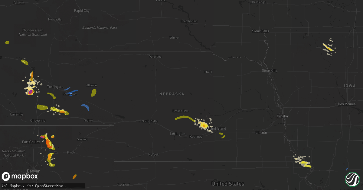
Hail Map in Nebraska on August 20, 2019
Get this storm
August 20 map
$229
one time, instant access
Download today. No call, no setup
Keep the $229
Bought the map and want the full workflow? Apply the entire $229 to a subscription within 7 days. None of it is wasted.
Every map, not just this one
This buys you this map. Subscription and you get every map we run, in the markets you choose from a few cities to whole states to nationwide. Plus real-time alerts the moment a storm fires.
Contact data
Name, contact info, occupancy, even credit band for addresses in the footprint. You go from where it hit to who to call.
Become the source they trust
Unlimited branding weather history reports on demand. You already have the documented answer ready for the property owner, and you are the one who showed up with it.
Property data and RoofTrace estimates
Pull up any address you have got, its value and the exact code rules for that jurisdiction, straight from One Click Code. Then RoofTrace estimates the squares, pitch, and roof value, priced the way you price.
Storm reports in Nebraska
Nebraska
| Date | Description |
|---|---|
| 08/20/20196:57 AM CDT | At 1157 PM MDT, severe thunderstorms were located along a line extending from Alliance Airport to 9 miles northwest of Lisco to near Brownson, moving east at 35 mph. HAZARD...70 mph wind gusts and quarter size hail. SOURCE...Radar indicated. IMPACT...Hail damage to vehicles is expected. Expect considerable tree damage. Wind damage is also likely to mobile homes, roofs, and outbuildings. Locations impacted include... Chappell, Oshkosh, Ellsworth, Lewellen, Lisco, Ashby, Antioch, Crescent Lake National Wildlife Refuge, Dogtown Flats, Swede Lake, Deer Lake, Britton Lake, Richardson Lake, Miles Lake, Mumper, Mount Vernon, Bourquim Hill, Herman Lake, Adams Flats and Sugar Loaf Hill.This includes the following highways... Highway 250 between mile markers 1 and 4. Highway 2 between mile markers 96 and 138. Highway 92 between mile markers 115 and 116. Interstate 80 in Nebraska between mile markers 78 and 89. |
| 08/20/20196:39 AM CDT | At 1138 PM MDT, severe thunderstorms were located along a line extending from 8 miles east of Wild Horse Butte to 12 miles east of Panorama Point, moving east at 35 mph. These are very dangerous storms. HAZARD...80 mph wind gusts and quarter size hail. SOURCE...Radar indicated. IMPACT...Flying debris will be dangerous to those caught without shelter. Mobile homes will be heavily damaged. Expect considerable damage to roofs, windows, and vehicles. Extensive tree damage and power outages are likely. Locations impacted include... Alliance, Sidney, Kimball, Bridgeport, Bayard, Hemingford, Potter, Lodgepole, Dalton, Dix, Gurley, Sunol, Oliver Campground, Brownson, Alliance Airport, Northport, Angora, Colton, Oliver Reservoir and Court House And Jail Rocks.This includes Interstate 80 in Nebraska between mile markers 5 and76. |
| 08/20/20194:35 AM CDT | A local report indicates 69 MPH wind near 1 S THEDFORD |
| 08/20/20193:35 AM CDT | A local report indicates 62 MPH wind near 1 ENE FRIEND |
| 08/20/20192:15 AM CDT | A local report indicates 58 MPH wind near BEATRICE |
| 08/20/201912:48 AM CDT | Hail ranging in size from peas up to golf balls fell for approximately 45 mins. This hail destroyed a melon and pumpkin patch... And this business located 7 miles east |
| 08/20/201912:47 AM CDT | Kneb automated weather station. |
| 08/20/201912:44 AM CDT | Kneb automated weather station. |
| 08/20/201912:41 AM CDT | Kneb automated weather station. |
| 08/20/201912:28 AM CDT | Storm chaser reports multiple trees down blocking county roads around melbeta. |
| 08/20/201912:26 AM CDT | Kneb weather station reported a 91 mph wind gust with extensive tree damage nearby. |
| 08/20/201912:11 AM CDT | Report from mping: trees uprooted or snapped; roof blown off. |
| 08/19/201911:48 PM CDT | Automated station report of 63kts. Reported at western nebraska regional airport. |
| 08/19/201911:46 PM CDT | Reports of several large tree branches down in gering. |
| 08/19/201911:41 PM CDT | Report from mping: 3-inch tree limbs broken; power poles broken. |
| 08/19/201911:39 PM CDT | Report from mping: 3-inch tree limbs broken; power poles broken. |
| 08/19/201911:34 PM CDT | Storm chaser reported 70 mph winds south of gering along highway 71. |
| 08/19/201911:34 PM CDT | Spotter reported estimated wind gusts of 55 to 60 mph. |
| 08/19/201911:34 PM CDT | Report from mping: 1-inch tree limbs broken; shingles blown off. |
| 08/19/201911:33 PM CDT | Corrects previous tstm wnd gst report from 1 e scottsbluff. Kneb weather station reported a 91 mph wind gust with extensive tree damage nearby. |
| 08/19/201911:27 PM CDT | Large rv trailer blown over in roddoux rv park in gering nebraska. Photos relayed from social media. Time is estimated based on nearby reports. |
All States Impacted by Hail Map on August 20, 2019
Cities Impacted by Hail Map on August 20, 2019
- Wheatland, WY
- Robinson, KS
- Hiawatha, KS
- Cairo, NE
- Hazard, NE
- Litchfield, NE
- Boelus, NE
- Loup City, NE
- Ravenna, NE
- Shelton, NE
- Rockville, NE
- Brainerd, MN
- Fort Ripley, MN
- Pierz, MN
- Wood River, NE
- Quinter, KS
- Fairborn, OH
- Rolla, MO
- Hoxie, KS
- Nunn, CO
- Ault, CO
- Pierce, CO
- Edgar Springs, MO
- Bushnell, NE
- Harrisburg, NE
- Douglas, WY
- Dannebrog, NE
- Saint Paul, NE
- Worthington, MO
- Queen City, MO
- Livonia, MO
- Grinnell, KS
- Gove, KS
- Bancroft, IA
- Denver, CO
- Herndon, VA
- Roggen, CO
- Park, KS
- La Salle, CO
- Evans, CO
- Greeley, CO
- Galeton, CO
- Gill, CO
- Eaton, CO
- Chase, KS
- Raymond, KS
- Briggsdale, CO
- Mason City, NE
- Oregon, MO
- Forest City, MO
- Titonka, IA
- Edina, MO
- Ellinwood, KS
- Fort Leonard Wood, MO
- Highland, KS
- Kimball, NE
- Burt, IA
- Albin, WY
- Rulo, NE
- White Cloud, KS
- Dublin, VA
- Keenesburg, CO
- Pleasanton, NE
- Maitland, MO
- Guernsey, WY
- Dunkirk, MD
- Upper Marlboro, MD
- Suitland, MD
- Andrews Air Force Base, MD
- Temple Hills, MD
- Chugwater, WY
- Strasburg, CO
- Yellow Springs, OH
- Capitol Heights, MD
- Washington, DC
- District Heights, MD
- Great Bend, KS
- Grainfield, KS
- Lu Verne, IA
- Craig, MO
- Novelty, MO
- Hurdland, MO
- Naval Anacost Annex, DC
- Troy, KS
- Wathena, KS
- Buffalo, MN
- Hays, KS
- Meriden, WY
- Lagrange, WY
- Steinauer, NE
- Sterling, VA
- Corwith, IA
- Kersey, CO
- Newburg, MO
- Dixon, MO
- Unionville, MO
- Merriman, NE
- Bucklin, KS
- Livermore, IA
- Sheridan, MO
- Falls City, NE
- Bridgeport, NE
- Garrett, WY
- Algona, IA
- College Park, MD
- Beltsville, MD
- Hyattsville, MD
- Saint James, MO
- Bushton, KS
- Offerle, KS
- Whittemore, IA
- Fenton, IA
- Lone Rock, IA
- Hiwassee, VA
- Radford, VA
- Savannah, MO
- Amazonia, MO
- Fillmore, MO
- Pine Bluffs, WY
- St John, KS
- Bayard, NE
- Foley, MN
- Verdon, NE
- Stella, NE
- Collyer, KS
- Elkins, WV
- Ewing, MO
- Graham, MO
- Barnard, MO
- Humboldt, NE
- Sterling, NE
- Cheyenne, WY
- Bethesda, MD
- Potomac, MD
- Rockville, MD
- Elk Creek, NE
- Tecumseh, NE
- Johnson, NE
- Beatrice, NE
- Kinsley, KS
- Fairfax, MO
- Perry, MI
- Morrice, MI
- Abingdon, VA
- Novinger, MO
- Falls Church, VA
- Arlington, VA
- Emden, MO
- Brashear, MO
- Kirksville, MO
- La Plata, MO
- Bethel, MO
- Philadelphia, MO
- Gibbs, MO
- Leonard, MO
- Knox City, MO
- Newark, MO
- Shelbyville, MO
- La Belle, MO
- Hudson, CO
- Hudson, KS
- Fairmont, NE
- Platteville, CO
- Grand Island, NE
- Lyman, NE
- Alda, NE
- Orchard, CO
- Farwell, NE
- Otter Lake, MI
- Otisville, MI
- Columbiaville, MI
- Millington, MI
- Salem, MO
- Auburn, NE
- Lakota, IA
- Buffalo, WY
- Kaycee, WY
- Lathrop, MO
- Turney, MO
- Ellsworth, NE
- Webberville, MI
- Oconto, NE
- Riner, VA
- Kahoka, MO
- Easton, MO
- Saint Joseph, MO
- Duke, MO
- Fairfax Station, VA
- Woodbridge, VA
- Bennett, CO
- Fowlerville, MI
- Baxter, MN
- Burns, WY
- Brentwood, MD
- Mount Rainier, MD
- Genoa, CO
- Dighton, KS
- Broken Bow, NE
- Geneseo, KS
- Mound City, MO
- Lorton, VA
- Alexandria, VA
- Springfield, VA
- Ansley, NE
- Milaca, MN
- Owosso, MI
- Pillager, MN
- Henderson, NE
- Wesley, IA
- Yoder, WY
- Claflin, KS
- Van Buren, MO
- Maysville, MO
- Bode, IA
- Lisco, NE
- Long Prairie, MN
- Great Falls, VA
- Merna, NE
- Hemingford, NE
- Marsland, NE
- Ottosen, IA
- McLean, VA
- Mitchell, NE
- Rock Port, MO
- Rozel, KS
- Plymouth, NE
- Western, NE
- Swanton, NE
- Gentry, MO
- Stanberry, MO
- Scottsbluff, NE
- Vienna, VA
- Reston, VA
- Bristol, VA
- Clifton, VA
- Glenrock, WY
- Glendo, WY
- Hawk Springs, WY
- Giltner, NE
- Doniphan, NE
- Angora, NE
- Harvard, NE
- Aurora, NE
- Morrill, NE
- Harrison, NE
- Minatare, NE
- Gering, NE
- Dalton, NE
- Lindon, CO
- Cokato, MN
- Howard Lake, MN
- Chillicothe, MO
- Williamsfield, IL
- Galesburg, IL
- Wataga, IL
- Burlington, IA
- Oneida, IL
- Victoria, IL
- East Peoria, IL
- Dunlap, IL
- Oquawka, IL
- Monmouth, IL
- Peoria Heights, IL
- Princeville, IL
- Brimfield, IL
- Seaton, IL
- Toulon, IL
- Mossville, IL
- Cameron, IL
- Edwards, IL
- Laura, IL
- Dahinda, IL
- Yates City, IL
- Henderson, IL
- East Galesburg, IL
- Little York, IL
- Knoxville, IL
- Alexis, IL
- Maquon, IL
- Gilson, IL
- Elmwood, IL
- Chillicothe, IL
- Metamora, IL
- Peoria, IL
- Edelstein, IL
- Gerlaw, IL
- Rock Island, IL
- Taylor Ridge, IL
- Reynolds, IL
- Milan, IL
- Hanna City, IL
- Trivoli, IL
- Glasford, IL
- Mount Pulaski, IL
- Delavan, IL
- Farmington, IL
- Hammond, IL
- Chestnut, IL
- Green Valley, IL
- Arthur, IL
- Cerro Gordo, IL
- San Jose, IL
- Ellisville, IL
- Canton, IL
- Pekin, IL
- Tuscola, IL
- Kingston Mines, IL
- Maroa, IL
- New Holland, IL
- La Place, IL
- Latham, IL
- Beason, IL
- Oreana, IL
- Forsyth, IL
- Tremont, IL
- Lovington, IL
- Warrensburg, IL
- Mapleton, IL
- Emden, IL
- Manito, IL
- London Mills, IL
- Decatur, IL
- Arcola, IL
- South Pekin, IL
- Argenta, IL
- Hartsburg, IL
- Kenney, IL
- Lincoln, IL
- Norris, IL
- Humboldt, IL
- Fairview, IL
- Pawnee, IL
- Chatham, IL
- Springfield, IL
- Pleasant Plains, IL
- Rochester, IL
- Petersburg, IL
- Edinburg, IL
- Cantrall, IL
- Sidell, IL
- Urbana, IL
- White Heath, IL
- Homer, IL
- De Land, IL
- Savoy, IL
- Bondville, IL
- Mansfield, IL
- Philo, IL
- Champaign, IL
- Metcalf, IL
- Monticello, IL
- Indianola, IL
- Fairmount, IL
- Sidney, IL
- Allerton, IL
- Seymour, IL
- Tolono, IL
- Ridge Farm, IL
- Chrisman, IL
- Batavia, IA
- Fairfield, IA
- Carman, IL
- Packwood, IA
- Mount Pleasant, IA
- Morning Sun, IA
- Olds, IA
- Winfield, IA
- Columbus Junction, IA
- New Boston, IL
- Danville, IA
- Middletown, IA
- Lockridge, IA
- Wapello, IA
- Gladstone, IL
- Hedrick, IA
- Brighton, IA
- Muscatine, IA
- Salem, IA
- New London, IA
- Wayland, IA
- Crawfordsville, IA
- West Burlington, IA
- Ottumwa, IA
- Libertyville, IA
- Donnellson, IA
- Stockport, IA
- West Point, IA
- Selma, IA
- Hillsboro, IA
- Birmingham, IA
- Douds, IA
- Eldon, IA
- Agency, IA
- Albia, IA
- Lovilia, IA
- Sylvia, KS
- Winona, KS
- Edson, KS
- Loretto, MN
- Maple Grove, MN
- Hamel, MN
- Minneapolis, MN


