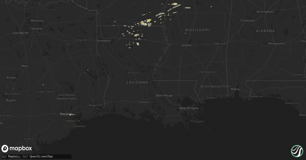
Hail Map in Louisiana on August 20, 2018
Get this storm
August 20 map
$229
one time, instant access
Download today. No call, no setup
Keep the $229
Bought the map and want the full workflow? Apply the entire $229 to a subscription within 7 days. None of it is wasted.
Every map, not just this one
This buys you this map. Subscription and you get every map we run, in the markets you choose from a few cities to whole states to nationwide. Plus real-time alerts the moment a storm fires.
Contact data
Name, contact info, occupancy, even credit band for addresses in the footprint. You go from where it hit to who to call.
Become the source they trust
Unlimited branding weather history reports on demand. You already have the documented answer ready for the property owner, and you are the one who showed up with it.
Property data and RoofTrace estimates
Pull up any address you have got, its value and the exact code rules for that jurisdiction, straight from One Click Code. Then RoofTrace estimates the squares, pitch, and roof value, priced the way you price.
Storm reports in Louisiana
Louisiana
| Date | Description |
|---|---|
| 08/20/20186:30 PM CDT | Numerous trees down. |
| 08/20/20186:22 PM CDT | Multiple trees down throughout the parish. |
| 08/20/20186:18 PM CDT | Tree downed on highway 585 near the intersection of highway 879. Another tree was downed on beebe road near the roundhill road intersection. |
| 08/20/20186:10 PM CDT | Tree downed in this area. |
| 08/20/20186:07 PM CDT | Trained weather spotter reported sustained wind gusts of 60mph. |
| 08/20/20185:55 PM CDT | Several trees and power lines reported down along n. White lightning rd. |
| 08/20/20185:55 PM CDT | Few trees & large limbs downed scattered throughout the parish. |
| 08/20/20185:50 PM CDT | Several trees and power lines down along highway 545. |
| 08/20/20185:15 PM CDT | *** 1 fatal *** a tree was downed on a mobile home on pilgrims rest church road northwest of spearsville killing a 45 year old woman inside the mobile home. The woman w |
| 08/20/20184:26 AM CDT | At 925 PM CDT, severe thunderstorms were located along a line extending from 7 miles northwest of Columbia to 8 miles west of Clarks to 10 miles east of Winnfield, moving southeast at 30 mph. HAZARD...60 mph wind gusts and penny size hail. SOURCE...Radar indicated. IMPACT...Expect damage to roofs, siding, and trees. Locations impacted include... Columbia, Olla, Clarks, Grayson, Urania, Tullos, Sikes, Spaulding, Vixen, Riverton, Standard, Kelly, Zenoria and Burlington. |
| 08/20/20183:30 AM CDT | At 830 PM CDT, a severe thunderstorm was located over Buckner, or 9 miles west of Mangham, moving southeast at 25 mph. HAZARD...60 mph wind gusts. SOURCE...Radar indicated. IMPACT...Expect damage to roofs, siding, and trees. This severe thunderstorm will remain over mainly rural areas of southwestern Richland Parish. |
| 08/20/20182:59 AM CDT | At 758 PM CDT, severe thunderstorms were located along a line extending from 6 miles east of Richwood to 14 miles south of Gibsland, moving east at 25 mph. HAZARD...70 mph wind gusts. SOURCE...Radar indicated. IMPACT...Expect considerable tree damage. Damage is likely to mobile homes, roofs, and outbuildings. Locations impacted include... Monroe, Jonesboro, Richwood, Chatham, Hodge, North Hodge, Dodson, East Hodge, Lucky, Bienville, Quitman, Eros, Sikes, Fondale, Vixen, Bosco, Riverton, Friendship, Liberty Hill and Pine Grove. |
| 08/20/20182:50 AM CDT | At 749 PM CDT, a severe thunderstorm was located near Richwood, or near Monroe, moving east at 20 mph. HAZARD...60 mph wind gusts. SOURCE...Radar indicated. IMPACT...Expect damage to roofs, siding, and trees. Locations impacted include... Rayville, Mangham, Start, Alto, Holly Ridge and Archibald. |
| 08/20/20182:06 AM CDT | At 705 PM CDT, severe thunderstorms were located along a line extending from near Nitta Yuma to near Onward to 7 miles south of Fitler, moving east at 40 mph. HAZARD...60 mph wind gusts. SOURCE...Law enforcement. Multiple trees were downed with these storms across northeast Louisiana. IMPACT...Expect damage to roofs, siding, and trees. Locations impacted include... Yazoo City, Redwood, Benton, Myrleville, Holly Bluff, Phoenix, Eagle Bend, Tinsley, Oak Ridge, Little Yazoo, Bentonia and Satartia. |
| 08/20/20182:04 AM CDT | At 704 PM CDT, a severe thunderstorm was located near Sterlington, or near Swartz, moving east southeast at 35 mph. HAZARD...60 mph wind gusts and penny size hail. SOURCE...Radar indicated. IMPACT...Expect damage to roofs, siding, and trees. Locations impacted include... Monroe, Swartz, Sterlington, Downsville, Fairbanks, D Arbonne, Perryville, Rocky Branch, Loch Lomon, Guthrie and Deshard. |
| 08/20/20181:56 AM CDT | At 655 PM CDT, severe thunderstorms were located along a line extending from near Swartz to 10 miles northeast of Ruston, moving east southeast at 40 mph. HAZARD...60 mph wind gusts and penny size hail. SOURCE...Radar indicated. IMPACT...Expect damage to roofs, siding, and trees. Locations impacted include... Monroe, Claiborne, West Monroe, Swartz, Brownsville-Bawcom, Brownsville-Bawcomville, Richwood, Choudrant, Drew, Calhoun, Millhaven, Folksville, Cheniere, Mineral Springs, Caderville, Pine Grove and Eureka. |
| 08/20/20181:35 AM CDT | At 634 PM CDT, severe thunderstorms were located along a line extending from near Kilbourne to near Oak Grove to Pioneer, moving east at 40 mph. HAZARD...60 mph wind gusts. SOURCE...Radar indicated. IMPACT...Expect damage to roofs, siding, and trees. Locations impacted include... Rolling Fork, Valley Park, Anguilla, Grace, Fitler, Onward, Mayersville and Cary. |
| 08/20/20181:25 AM CDT | At 624 PM CDT, a severe thunderstorm was located near Farmerville, or 18 miles northwest of Claiborne, moving east at 35 mph. HAZARD...60 mph wind gusts and penny size hail. SOURCE...Radar indicated. IMPACT...Expect damage to roofs, siding, and trees. Locations impacted include... Monroe, Swartz, Farmerville, Sterlington, Downsville, Fairbanks, D Arbonne, Perryville, Loch Lomon, Spencer, Haile, Linville, Bayou D Arbonne Lake, Rocky Branch, Guthrie and Deshard. |
| 08/20/201812:47 AM CDT | At 546 PM CDT, a severe thunderstorm was located 12 miles northeast of Arcadia, or 14 miles east of Homer, moving east at 30 mph. Dubach is in the path of this severe thunderstorm. HAZARD...60 mph wind gusts and nickel size hail. SOURCE...Radar indicated. IMPACT...Expect damage to roofs, siding, and trees. Locations impacted include... Farmerville, Dubach, Vienna, Lisbon, Downsville, D Arbonne, Bayou D Arbonne Lake, Corinth, Shiloh, Mount Zion and Unionville. |
| 08/19/20188:30 PM CDT | Several reports of trees down across the parish. |
| 08/19/20187:38 PM CDT | Measured wind gust reported at the monroe regional airport by asos. |
| 08/19/20187:35 PM CDT | Trees and power lines down across monroe. |
| 08/19/20187:10 PM CDT | Trained spotter reported trees down two miles west of point. |
| 08/19/20187:00 PM CDT | Power lines down in the city of monroe. |
| 08/19/20187:00 PM CDT | Multiple trees down along hwy 557 in west monroe near luna. |
All States Impacted by Hail Map on August 20, 2018
Cities Impacted by Hail Map on August 20, 2018
- Pima, AZ
- Dermott, AR
- Lake Village, AR
- Minter City, MS
- Drew, MS
- Shaw, MS
- Cleveland, MS
- Doddsville, MS
- Ruleville, MS
- Boyle, MS
- Sierra Vista, AZ
- Benoit, MS
- Greenville, MS
- Sterlington, LA
- Tucson, AZ
- Metropolis, IL
- Paducah, KY
- Brookport, IL
- West Paducah, KY
- Cottonwood, AZ
- Downsville, LA
- Tubac, AZ
- Holly Grove, AR
- Clarendon, AR
- Douglas, AZ
- Nogal, NM
- Sahuarita, AZ
- Conway, AR
- Sherwood, AR
- Jacksonville, AR
- Lambert, MS
- Tutwiler, MS
- Peridot, AZ
- San Carlos, AZ
- Pasadena, TX
- Huttig, AR
- Strong, AR
- West Monroe, LA
- Winslow, AZ
- Leland, MS
- Prescott Valley, AZ
- Dewey, AZ
- Bentonia, MS
- Benton, MS
- Deming, NM
- Etoile, TX
- Marvell, AR
- Poplar Grove, AR
- Rio Rico, AZ
- Marks, MS
- Tombstone, AZ
- Crossett, AR
- Sledge, MS
- Coahoma, MS
- Dundee, MS
- Helena, AR
- Crenshaw, MS
- Hamburg, AR
- Mescalero, NM
- Georgetown, TX
- Eros, LA
- Dubach, LA
- Merigold, MS
- Lexa, AR
- West Helena, AR
- Batesville, MS
- Marathon, TX
- Bernice, LA
- Sells, AZ
- Clarkdale, AZ
- Deer Park, TX
- Doniphan, MO
- Alton, MO
- Baytown, TX
- La Porte, TX
- Quitman, LA
- Benson, AZ
- Lyon, MS
- Clarksdale, MS
- Courtland, MS
- Charleston, MS
- Enid, MS
- Water Valley, MS
- Sardis, MS
- Pope, MS
- Oakland, MS
- Dryden, TX
- Palestine, AR
- Crocketts Bluff, AR
- De Witt, AR
- Wabash, IN
- La Fontaine, IN
- Nogales, AZ
- Elizabeth, IN
- New Middletown, IN
- Corydon, IN
- Farmerville, LA
- Mason, TX
- Marion, LA
- Sheffield, TX
- Hermitage, AR
- Sunflower, MS
- Gatewood, MO
- Wheatley, AR
- Brinkley, AR
- Spearsville, LA
- Shongaloo, LA
- Ward, AR
- McCrory, AR
- Beulah, MS
- Waverly, GA
- Cabot, AR
- Jonesboro, LA
- Eudora, AR
- Ruston, LA
- Bryan, TX
- Hearne, TX
- Haynesville, LA
- Junction City, AR
- Lillie, LA
- Hollandale, MS
- Oxford, MS
- Taylor, MS
- Patagonia, AZ
- Magnolia, AR
- Arcadia, LA
- Homer, LA
- Indianola, MS
- Huntington, TX
- Fremont, MO
- Des Arc, AR
- Dillon, MT
- Amado, AZ
- Bastrop, LA
- Converse, IN
- Amboy, IN
- Portland, AR
- Gibsland, LA
- Cotton Plant, AR
- Monticello, AR
- Marianna, AR
- Bald Knob, AR
- Augusta, AR
- Montrose, AR
- Griffithville, AR
- Mantee, MS
- Maben, MS
- Monroe, LA
- Watson, AR
- Colt, AR
- Lumberton, TX
- Greenwood, MS
- Holcomb, MS
- Carrollton, MS
- Saint David, AZ
- Fountain Hill, AR
- Hunter, AR
- Plant City, FL
- Dover, FL
- Hughes, AR
- Widener, AR
- Heth, AR
- Calhoun, LA
- Tumacacori, AZ
- Royal Center, IN
- Kewanna, IN


