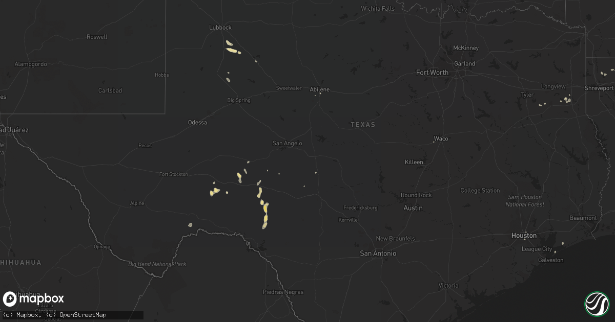
Hail Map in Texas on August 19, 2015
Get this storm
August 19 map
$229
one time, instant access
Download today. No call, no setup
Keep the $229
Bought the map and want the full workflow? Apply the entire $229 to a subscription within 7 days. None of it is wasted.
Every map, not just this one
This buys you this map. Subscription and you get every map we run, in the markets you choose from a few cities to whole states to nationwide. Plus real-time alerts the moment a storm fires.
Contact data
Name, contact info, occupancy, even credit band for addresses in the footprint. You go from where it hit to who to call.
Become the source they trust
Unlimited branding weather history reports on demand. You already have the documented answer ready for the property owner, and you are the one who showed up with it.
Property data and RoofTrace estimates
Pull up any address you have got, its value and the exact code rules for that jurisdiction, straight from One Click Code. Then RoofTrace estimates the squares, pitch, and roof value, priced the way you price.
Storm reports in Texas
Texas
| Date | Description |
|---|---|
| 08/19/20151:51 AM CDT | Pharr police department reports tree blown down by thunderstorm winds at 106 north palm and also at the intersection of jackson and ridge. |
| 08/19/20151:30 AM CDT | Mission police department reports powerlines down due to strong winds at inspiration and fm 495 and at 1413 doherty. Also big tree branches down at inspiration and fm 4 |
| 08/19/20151:03 AM CDT | Mission police department reports quarter-size hail throughout much of the city of mission. |
| 08/19/201512:35 AM CDT | Palmview police department reported golf ball size hail at the intersection of expressway 83 and la homa road. |
All States Impacted by Hail Map on August 19, 2015
Cities Impacted by Hail Map on August 19, 2015
- Linden, NC
- Ozona, TX
- Tahoka, TX
- Post, TX
- Erwin, NC
- Rockwood, TN
- Ten Mile, TN
- Kingston, TN
- La Joya, TX
- Mission, TX
- Mcallen, TX
- Penitas, TX
- Dryden, TX
- Tell, TX
- Childress, TX
- Mocksville, NC
- Woodleaf, NC
- Cooleemee, NC
- Menard, TX
- Del Rio, TX
- Bunnlevel, NC
- Junction, TX
- Zolfo Springs, FL
- Eldorado, TX
- San Juan, TX
- Donna, TX
- Pharr, TX
- Alamo, TX
- Wilson, TX
- Hedley, TX
- Hallsboro, NC
- Clarkton, NC
- Whiteville, NC
- Marshall, TX
- Port Bolivar, TX
- Rio Grande City, TX
- Quanah, TX
- Beckville, TX
- Sonora, TX
- Abilene, TX
- Bartow, FL
- Bradley, FL
- Mulberry, FL
- Bowling Green, FL
- Concord, NC
- Spring City, TN
- Edinburg, TX
- Wagram, NC
- Houston, TX
- Paducah, TX
- Jacksonville, FL
- Cotton Valley, LA
- Ackerly, TX
- Grulla, TX
- Sullivan City, TX
- Statesville, NC
- Hiddenite, NC
- Stony Point, NC
- Brentwood, TN
- Franklin, TN
- Marathon, TX
- Weslaco, TX
- Ehrhardt, SC
- Gail, TX
- Benton, LA
- Bamberg, SC
- Barnhart, TX
- Sheffield, TX
- Summerville, SC
- Kannapolis, NC
- Rockwell, NC
- Fluvanna, TX
- Woodway, TX
- McGregor, TX
- Branchville, SC
- Anahuac, TX
- Wauchula, FL
- Henderson, TX
- Overton, TX
- Rome, GA
- Armuchee, GA
- Troup, TX
- Hilliard, FL
- Carthage, TX
- Summerville, GA
- Maplesville, AL
- Patterson, GA


