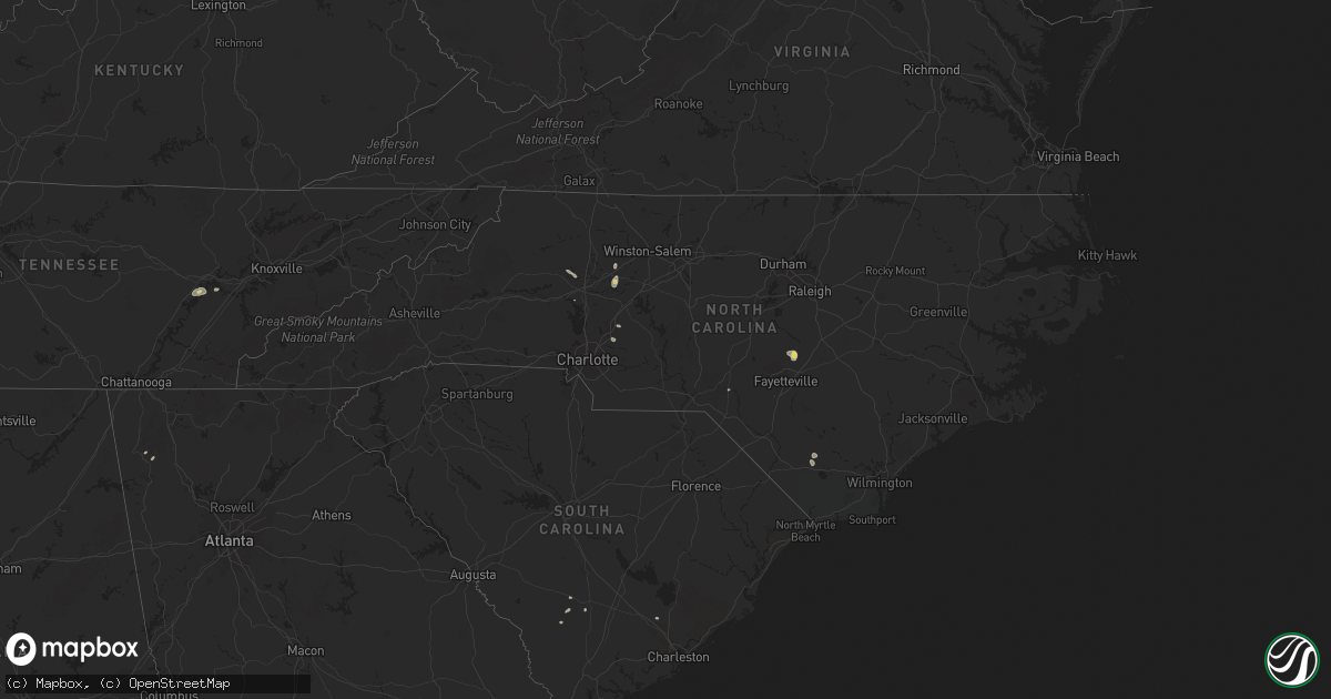
Hail Map in North Carolina on August 19, 2015
Get this storm
August 19 map
$229
one time, instant access
Download today. No call, no setup
Keep the $229
Bought the map and want the full workflow? Apply the entire $229 to a subscription within 7 days. None of it is wasted.
Every map, not just this one
This buys you this map. Subscription and you get every map we run, in the markets you choose from a few cities to whole states to nationwide. Plus real-time alerts the moment a storm fires.
Contact data
Name, contact info, occupancy, even credit band for addresses in the footprint. You go from where it hit to who to call.
Become the source they trust
Unlimited branding weather history reports on demand. You already have the documented answer ready for the property owner, and you are the one who showed up with it.
Property data and RoofTrace estimates
Pull up any address you have got, its value and the exact code rules for that jurisdiction, straight from One Click Code. Then RoofTrace estimates the squares, pitch, and roof value, priced the way you price.
Storm reports in North Carolina
North Carolina
| Date | Description |
|---|---|
| 08/19/20156:25 PM CDT | Tree down across wire rd and josey williams rd 4 miles wnw of linden. |
| 08/19/20156:05 PM CDT | Tree down across ross rd and bunnlevel erwin rd 4 miles west of erwin. |
| 08/19/20155:00 PM CDT | At least 5 trees were blown over by the storm in and near farmington. One of the roads where a tree fell was mallard road. |
| 08/19/20153:35 PM CDT | A few trees fell when the storm came through concord. Radar indicates greater wind max on the east side of the city after 430 pm. |
| 08/19/20152:23 PM CDT | Powerlines down and arcing across white farm road. A tree was down blocking the roadway near the reported downed powerlines. |
| 08/19/20152:09 PM CDT | A tree down on kingswood road. More trees down in this same area along nearby turnersburg highway. |
| 08/19/20151:56 PM CDT | A tree and a power line down on a garage. |
All States Impacted by Hail Map on August 19, 2015
Cities Impacted by Hail Map on August 19, 2015
- Linden, NC
- Ozona, TX
- Tahoka, TX
- Post, TX
- Erwin, NC
- Rockwood, TN
- Ten Mile, TN
- Kingston, TN
- La Joya, TX
- Mission, TX
- Mcallen, TX
- Penitas, TX
- Dryden, TX
- Tell, TX
- Childress, TX
- Mocksville, NC
- Woodleaf, NC
- Cooleemee, NC
- Menard, TX
- Del Rio, TX
- Bunnlevel, NC
- Junction, TX
- Zolfo Springs, FL
- Eldorado, TX
- San Juan, TX
- Donna, TX
- Pharr, TX
- Alamo, TX
- Wilson, TX
- Hedley, TX
- Hallsboro, NC
- Clarkton, NC
- Whiteville, NC
- Marshall, TX
- Port Bolivar, TX
- Rio Grande City, TX
- Quanah, TX
- Beckville, TX
- Sonora, TX
- Abilene, TX
- Bartow, FL
- Bradley, FL
- Mulberry, FL
- Bowling Green, FL
- Concord, NC
- Spring City, TN
- Edinburg, TX
- Wagram, NC
- Houston, TX
- Paducah, TX
- Jacksonville, FL
- Cotton Valley, LA
- Ackerly, TX
- Grulla, TX
- Sullivan City, TX
- Statesville, NC
- Hiddenite, NC
- Stony Point, NC
- Brentwood, TN
- Franklin, TN
- Marathon, TX
- Weslaco, TX
- Ehrhardt, SC
- Gail, TX
- Benton, LA
- Bamberg, SC
- Barnhart, TX
- Sheffield, TX
- Summerville, SC
- Kannapolis, NC
- Rockwell, NC
- Fluvanna, TX
- Woodway, TX
- McGregor, TX
- Branchville, SC
- Anahuac, TX
- Wauchula, FL
- Henderson, TX
- Overton, TX
- Rome, GA
- Armuchee, GA
- Troup, TX
- Hilliard, FL
- Carthage, TX
- Summerville, GA
- Maplesville, AL
- Patterson, GA


