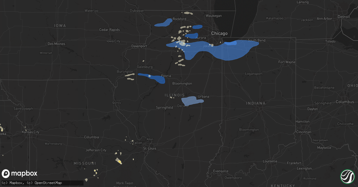
Hail Map in Illinois on August 18, 2025
Get this storm
August 18 map
$229
one time, instant access
Download today. No call, no setup
Keep the $229
Bought the map and want the full workflow? Apply the entire $229 to a subscription within 7 days. None of it is wasted.
Every map, not just this one
This buys you this map. Subscription and you get every map we run, in the markets you choose from a few cities to whole states to nationwide. Plus real-time alerts the moment a storm fires.
Contact data
Name, contact info, occupancy, even credit band for addresses in the footprint. You go from where it hit to who to call.
Become the source they trust
Unlimited branding weather history reports on demand. You already have the documented answer ready for the property owner, and you are the one who showed up with it.
Property data and RoofTrace estimates
Pull up any address you have got, its value and the exact code rules for that jurisdiction, straight from One Click Code. Then RoofTrace estimates the squares, pitch, and roof value, priced the way you price.
Storm reports in Illinois
Illinois
| Date | Description |
|---|---|
| 08/18/20256:20 PM CDT | Several 6 to 7 inch diameter tree limbs were knocked down with some blocking a street in southern freeport for a time. Time estimated by radar. |
| 08/18/20256:11 PM CDT | Report of several small branches generally between 1 to 2 inches in diameter down in freeport. |
| 08/18/20255:50 PM CDT | Tree down at stewart and wells streets. |
| 08/18/20255:45 PM CDT | Trees and power lines down with some roads blocked. |
| 08/18/20255:30 PM CDT | Tree down blocking the intersection of u.s. 6 and highway 84. |
| 08/18/20255:26 PM CDT | 2-4 inch diameter branch down just south of 36th avenue court. |
| 08/18/20255:25 PM CDT | Trees and power lines down in town. |
| 08/18/20255:18 PM CDT | Power lines down in coal valley. |
| 08/18/20254:06 PM CDT | Three power poles down on old state road between five points road and church rd west of sycamore. Time estimated from radar. |
| 08/18/20253:52 PM CDT | Large tree across the whole road... Illinois 23 north of illinois 72... Northeast of genoa. Time estimated from radar. |
| 08/18/20253:50 PM CDT | Many trees down northeast of genoa along ash road between north state and illinois route 23. Damage includes poles... Trees and wires. Time estimated from radar. |
| 08/18/20253:48 PM CDT | Tree damage around genoa... North and south of town. Time estimated from radar. |
| 08/18/20253:45 AM CDT | Delayed report. Part of a metal roof blown off a building at south farms uiuc. Time estimated from radar. |
| 08/18/20253:15 AM CDT | Delayed report. Two trees were blown down in monticello. Time estimated from radar. |
| 08/18/20253:11 AM CDT | Delayed report. Damage to trees and cornfields south of of argenta. Time estimated from radar. |
| 08/18/20253:07 AM CDT | Delayed report. Extensive damage was reported across maroa. Township building roof on south wood street was blown off. Approx 100 trees were blown down across town. Cam |
| 08/18/20253:06 AM CDT | Delayed report. Extensive tree damage on a property in forsyth. Video of numerous large branches down. Via social media. Time estimated via radar. |
| 08/17/20259:05 PM CDT | North side of peoria. |
| 08/17/20258:58 PM CDT | Large tree branch broken off near the intersection of s. 8th st. And prince st. |
| 08/17/20258:18 PM CDT | A local report indicates 58 MPH wind near 3 NNW Plainfield |
| 08/17/20257:52 PM CDT | Severe winds lasted 2-3 minu |
| 08/17/20257:52 PM CDT | Severe winds lasted 2-3 minutes. |
| 08/17/20257:50 PM CDT | Estimated 50 to 60 mph w |
| 08/17/20257:50 PM CDT | Estimated 50 to 60 mph wind gusts. |
| 08/17/20257:30 PM CDT | Six inch tree branches down. Time estimated from radar data. |
All States Impacted by Hail Map on August 18, 2025
Cities Impacted by Hail Map on August 18, 2025
- Lemmon, SD
- Auburn, NE
- Centralia, KS
- Sedgwick, CO
- Dalton, NE
- Seneca, KS
- Goff, KS
- Corning, KS
- Riley, KS
- Woodville, MS
- Stamford, TX
- Roscoe, IL
- Centreville, MS
- Caledonia, IL
- Poplar Grove, IL
- Kaplan, LA
- Sylvester, TX
- Anson, TX
- Gloster, MS
- Capron, IL
- Saint Francisville, LA
- Hamlin, TX
- Harvard, IL
- Bell City, LA
- Maringouin, LA
- Batchelor, LA
- Liberty, MS
- Colorado Springs, CO
- Grand Chenier, LA
- Satartia, MS
- Deadwood, SD
- Lindenwood, IL
- Florissant, CO
- Lettsworth, LA
- Conifer, CO
- Etoile, TX
- Polk City, FL
- Sedalia, CO
- Ponchatoula, LA
- Palmetto, LA
- Plaucheville, LA
- Lincoln, NM
- Capitan, NM
- Simmesport, LA
- Nemo, SD
- Piedmont, SD
- Deville, LA
- Glynn, LA
- Rougon, LA
- Jarreau, LA
- Childress, TX
- Limon, CO
- Groveland, FL
- Troy, MO
- Wright City, MO
- Montreal, MO
- Linn Creek, MO
- Saint Elizabeth, MO
- Tuscumbia, MO
- Esmond, IL
- Roscoe, TX
- Blackwell, TX
- Maryneal, TX
- Nacogdoches, TX
- Sturgis, SD
- Rapid City, SD
- Ramah, CO
- Washington, LA
- Western Grove, AR
- Harrison, AR
- Vendor, AR
- Hill City, SD
- Owensville, MO
- Hermann, MO
- Dry Creek, LA
- Kirkland, IL
- Rochelle, IL
- New Haven, MO
- Meadow, SD
- Carrington, ND
- Iowa, LA
- Burns, WY
- Lebanon, MO
- Genoa, CO
- Oakdale, LA
- Arriba, CO
- Deer Trail, CO
- Leslie, MO
- Gerald, MO
- Wentzville, MO
- Mittie, LA
- West Brooklyn, IL
- Calhan, CO
- Crocker, MO
- Rush, CO
- Hermanville, MS
- Byers, CO
- Sycamore, IL
- Kingston, IL
- Clare, IL
- Woodrow, CO
- Picayune, MS
- Bison, SD
- Opelousas, LA
- Dupree, SD
- Hampshire, IL
- Ocala, FL
- Pine Bluffs, WY
- Dixon, MO
- Pingree, ND
- Raymond, MS
- Burlington, IL
- Rosston, OK
- Maple Park, IL
- Pattison, MS
- Malta, IL
- Kensal, ND
- Utica, MS
- Strasburg, CO
- Kinder, LA
- Mount Enterprise, TX
- Compton, IL
- Dunnellon, FL
- Elgin, IL
- Shabbona, IL
- Dekalb, IL
- Lee, IL
- Waterman, IL
- Hinckley, IL
- Cedar Key, FL
- Inglis, FL
- Spokane, MO
- Oberlin, LA
- Hugo, CO
- Waynesville, MO
- Berryville, AR
- Hammond, LA
- Canadian, TX
- Lake Saint Louis, MO
- Basile, LA
- O'Fallon, MO
- Port Gibson, MS
- Genoa, IL
- Gilberts, IL
- Dundee, IL
- Elburn, IL
- Big Rock, IL
- Flagler, CO
- Laneville, TX
- Henderson, TX
- Reklaw, TX
- Rosebud, MO
- Cushing, TX
- Wiggins, CO
- Saint Joseph, LA
- Kilgore, TX
- Fordland, MO
- Marshfield, MO
- Glenfield, ND
- Epps, LA
- Sullivan, MO
- Bourbon, MO
- Saint Robert, MO
- Alto, TX
- Eunice, LA
- Bushnell, NE
- Branch, LA
- Crowley, LA
- Highlandville, MO
- Cuba, MO
- Buffalo, OK
- Church Point, LA
- Walker, LA
- Iota, LA
- Hermosa, SD
- Seibert, CO
- Sublette, IL
- Mendota, IL
- Gilbert, LA
- Laverne, OK
- Rayne, LA
- Buchanan, ND
- Fort Leonard Wood, MO
- Fort Morgan, CO
- Rogersville, MO
- Rusk, TX
- Sugar Grove, IL
- Atwood, KS
- Caputa, SD
- Ellis, KS
- Lubbock, TX
- New Waverly, TX
- Baton Rouge, LA
- Natoma, KS
- Plainville, KS
- Licking, MO
- Salem, MO
- Fargo, OK
- Provencal, LA
- Robertsville, MO
- Lonedell, MO
- Denham Springs, LA
- Branson, MO
- Collyer, KS
- Prairieville, LA
- Webster, FL
- Warren, TX
- Vona, CO
- Aurora, IL
- Batavia, IL
- Paradise, KS
- Catharine, KS
- Victoria, KS
- Eagle Butte, SD
- Lantry, SD
- Eunice, NM
- Winona, KS
- Seymour, MO
- Quinter, KS
- Bryant, IA
- Clinton, IA
- Goose Lake, IA
- Wharton, TX
- East Bernard, TX
- Bedias, TX
- Clayton, LA
- Medford, OK
- Franklin, LA
- Jeanerette, LA
- Richards, TX
- Bushnell, FL
- Morriston, FL
- Wildwood, FL
- Grovespring, MO
- Stratton, CO
- Edson, KS
- Goodland, KS
- Gorham, KS
- Kennard, TX
- De Berry, TX
- Beloit, WI
- Oakley, KS
- Liberty, TX
- Willis, TX
- Anderson, TX
- Cope, CO
- Houston, TX
- Bethune, CO
- Shattuck, OK
- Dacoma, OK
- Alva, OK
- May, OK
- Logansport, LA
- Grand Cane, LA
- Kanorado, KS
- Tonkawa, OK
- Dayton, TX
- Clinton, WI
- Wakeeney, KS
- Goldonna, LA
- Williston, FL
- Earlville, IL
- Paw Paw, IL
- Sykeston, ND
- Burlington, CO
- Gage, OK
- Hunter, OK
- Pond Creek, OK
- Lamont, OK
- New Raymer, CO
- Crockett, TX
- Nardin, OK
- Morgan City, LA
- Devers, TX
- Mansfield, LA
- Mount Carroll, IL
- Lanark, IL
- Milledgeville, IL
- Shannon, IL
- Forreston, IL
- Baileyville, IL
- Freeport, IL
- Weskan, KS
- Mount Morris, IL
- Leaf River, IL
- German Valley, IL
- Ridott, IL
- Palco, KS
- Ypsilanti, ND
- Ogallah, KS
- Gate, OK
- Hackberry, LA
- Jamestown, ND
- Spiritwood, ND
- Colby, KS
- Morland, KS
- Monroe, LA
- Grace City, ND
- Anahuac, TX
- Anton, CO
- Grubville, MO
- Baytown, TX
- Beaumont, TX
- Port Arthur, TX
- Katy, TX
- Vivian, LA
- Mooringsport, LA
- Sterling, CO
- Hayes, SD
- Fort Pierre, SD
- Akron, CO
- Alliance, NE
- Steward, IL
- Cypress, TX
- Stoneham, CO
- Hays, KS
- Hamshire, TX
- Venus, FL
- Bienville, LA
- Saline, LA
- Tomball, TX
- Wimbledon, ND
- Osyka, MS
- Winnie, TX
- Woodworth, ND
- Levant, KS
- Amboy, IL
- Mooreland, OK
- Chester, OK
- Winnfield, LA
- Carrier, OK
- Grainfield, KS
- Hoxie, KS
- Robeline, LA
- Courtenay, ND
- Magnolia, MS
- Groom, TX
- Pampa, TX
- Franklin Grove, IL
- Gove, KS
- Fulshear, TX
- Brookshire, TX
- Park, KS
- Natchitoches, LA
- Campti, LA
- Pelican, LA
- Enid, OK
- Lahoma, OK
- Sanborn, ND
- Hill City, KS
- Bogue, KS
- Sharon Springs, KS
- Marion, ND
- Hartford, AR
- Pleasant Hill, LA
- Brewster, KS
- Punta Gorda, FL
- Isabella, OK
- Dickey, ND
- Litchville, ND
- Lamoure, ND
- Montpelier, ND
- Walnut, IL
- Ohio, IL
- La Moille, IL
- Van Orin, IL
- Arlington, IL
- Triumph, IL
- Berlin, ND
- Verona, ND
- North Zulch, TX
- Clarendon, TX
- Taloga, OK
- Goodrich, TX
- Waukomis, OK
- Dazey, ND
- Mokena, IL
- Orland Park, IL
- Hemphill, TX
- Gettysburg, SD
- Converse, LA
- Fort Ransom, ND
- Spring, TX
- Cherry Creek, SD
- De Witt, IA
- Wanblee, SD
- Hartville, MO
- Ball, LA
- Pineville, LA
- Milam, TX
- Utica, IL
- Ottawa, IL
- Marseilles, IL
- Serena, IL
- Leland, IL
- Sheridan, IL
- Plano, IL
- Yorkville, IL
- Millington, IL
- Millbrook, IL
- Wedron, IL
- Sandwich, IL
- Somonauk, IL
- Newark, IL
- Troy Grove, IL
- La Salle, IL
- Grand Ridge, IL
- Lisbon, ND
- Bellaire, TX
- Seiling, OK
- Okeene, OK
- Noble, LA
- Zwolle, LA
- Oakwood, OK
- Cloutierville, LA
- Grinnell, KS
- Streator, IL
- Seneca, IL
- Morris, IL
- Ransom, IL
- Verona, IL
- Minooka, IL
- Plainfield, IL
- Joliet, IL
- Shorewood, IL
- Channahon, IL
- Crest Hill, IL
- Roseville, IL
- Berwick, IL
- Avon, IL
- Saint Augustine, IL
- London Mills, IL
- Fairview, IL
- Farmington, IL
- Oakes, ND
- Lostant, IL
- Wenona, IL
- Oshkosh, NE
- Tylertown, MS
- Fairview, OK
- Mora, LA
- Toluca, IL
- Wellington, TX
- Happy, TX
- Many, LA
- Canton, IL
- Norris, IL
- Elmwood, IL
- Kinsman, IL
- Lockport, IL
- Rutland, IL
- Kentwood, LA
- Longdale, OK
- Canton, OK
- Lomax, IL
- Stronghurst, IL
- Tinley Park, IL
- Florien, LA
- Healy, KS
- Glasford, IL
- Trivoli, IL
- New Lenox, IL
- Manhattan, IL
- Wilmington, IL
- Elwood, IL
- Homer Glen, IL
- Monee, IL
- Frankfort, IL
- Chesterton, IN
- Gary, IN
- Hobart, IN
- Portage, IN
- Lake Station, IN
- Valparaiso, IN
- East Chicago, IN
- Hanna City, IL
- Mapleton, IL
- Raritan, IL
- Media, IL
- Dana, IL
- Smithshire, IL
- Akron, AL
- Lebanon, SD
- Long Point, IL
- La Harpe, IL
- Michigan City, IN
- Pekin, IL
- Kingston Mines, IL
- Manito, IL
- South Pekin, IL
- Green Valley, IL
- Peotone, IL
- Manteno, IL
- Grant Park, IL
- Momence, IL
- Matteson, IL
- University Park, IL
- Beecher, IL
- Crete, IL
- Arcadia, FL
- Hennessey, OK
- Fairmont, OK
- Dixon, IL
- Bison, OK
- Schneider, IN
- Lake Village, IN
- Lowell, IN
- Cedar Lake, IN
- Dyer, IN
- Steger, IL
- Park Forest, IL
- Saint John, IN
- Chicago Heights, IL
- Richton Park, IL
- Schererville, IN
- Crown Point, IN
- Griffith, IN
- Munster, IN
- Highland, IN
- Olympia Fields, IL
- Glenwood, IL
- Lansing, IL
- Flossmoor, IL
- Thornton, IL
- Hammond, IN
- Homewood, IL
- Merrillville, IN
- Hebron, IN
- Demotte, IN
- Shelby, IN
- Peoria, IL
- Pecatonica, IL
- Fingal, ND
- Enderlin, ND
- Britton, SD
- Hoven, SD
- Marksville, LA
- Peru, IL
- Butler, OK
- Kingfisher, OK
- Oglesby, IL
- Holcomb, KS
- Blandinsville, IL
- Perkinston, MS
- Tonica, IL
- Lake City, SD
- Varna, IL
- Putnam, OK
- Milnor, ND
- Rio, IL
- Thomas, OK
- Custer City, OK
- Boone Grove, IN
- Wheatfield, IN
- Kouts, IN
- Thayer, IN
- Walkerton, IN
- Westville, IN
- Wanatah, IN
- Knox, IN
- North Judson, IN
- La Porte, IN
- San Pierre, IN
- Hamlet, IN
- Union Mills, IN
- Kingsford Heights, IN
- La Crosse, IN
- Hanna, IN
- Mishawaka, IN
- South Bend, IN
- Lakeville, IN
- North Liberty, IN
- Bremen, IN
- Mill Creek, IN
- Rolling Prairie, IN
- Grovertown, IN
- New Carlisle, IN
- Penokee, KS
- Rensselaer, IN
- Fair Oaks, IN
- Ransom, KS
- Culbertson, NE
- Levelland, TX
- Egan, LA
- Estherwood, LA
- Morse, LA
- Mermentau, LA
- Jennings, LA
- Lake Arthur, LA
- Romeoville, IL
- Oswego, IL
- Maquon, IL
- Lucas, KS
- Luray, KS
- Dorrance, KS
- Watkins, CO
- Aurora, CO
- Bennett, CO
- Mchenry, ND
- Sutton, ND
- Binford, ND
- Dolton, IL
- South Holland, IL
- Beverly Shores, IN
- Calumet City, IL
- Elkhart, IL
- Lincoln, IL
- Maroa, IL
- Argenta, IL
- Monticello, IL
- Cisco, IL
- Weldon, IL
- Clinton, IL
- De Land, IL
- Mansfield, IL
- White Heath, IL
- Decatur, IL
- Oreana, IL
- Forsyth, IL
- Cerro Gordo, IL
- Delia, KS
- Mayetta, KS
- Milmine, IL
- Hammond, IL
- La Place, IL
- Bement, IL
- Ivesdale, IL
- Sadorus, IL
- Tolono, IL
- Hoyt, KS
- Champaign, IL
- Topeka, KS
- Meriden, KS
- Emporia, KS
- Bartlesville, OK
- Waverly, KS
- Grantville, KS
- Wann, OK
- Groveton, TX
- Ochelata, OK
- Ramona, OK
- Barnsdall, OK
- Dewey, OK
- Kansas City, MO
- Kansas City, KS


