Hail Map in Milbank, SD on August 18, 2017
The weather event in Milbank, SD on August 18, 2017 includes Hail map. 19 states and 526 cities were impacted and suffered possible damage. The total estimated number of properties impacted is 2,320.
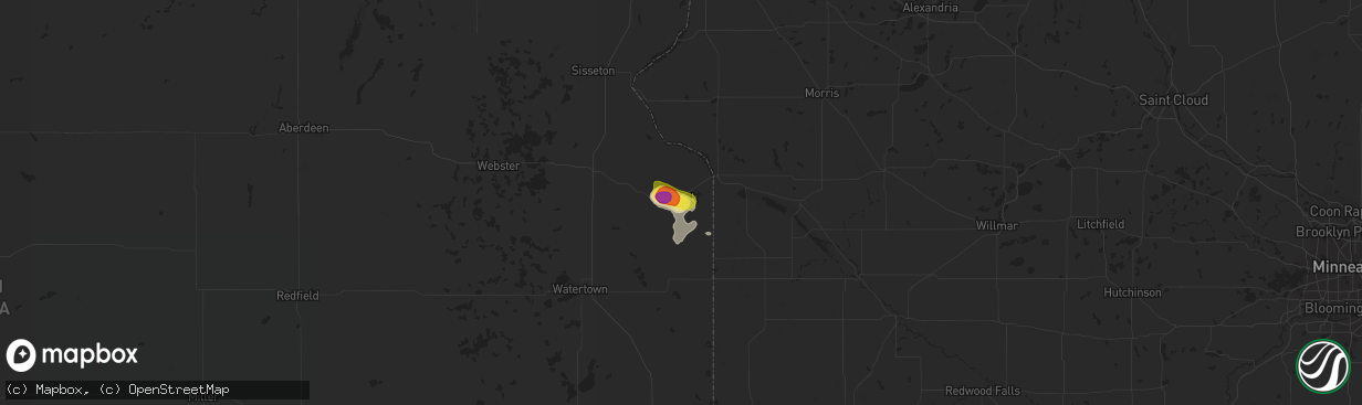
Hail
2,320
Estimated number of impacted properties by a 1.00" hail or larger1,985
Estimated number of impacted properties by a 1.75" hail or larger0
Estimated number of impacted properties by a 2.50" hail or largerStorm reports in Milbank, SD
Milbank, SD
| Date | Description |
|---|---|
| 08/18/20173:06 PM CDT | Radar estimated time. |
| 08/18/20172:50 PM CDT | Mobile mesonet instruments measured the strong winds. |
| 08/18/20172:42 PM CDT | Report and video relayed through social media. Hail blanketed the entire u.s. Highway 12 roadway. |
| 08/18/20172:40 PM CDT | Report relayed through social media. |
| 08/18/20172:35 PM CDT | No damage apparent at time of call. |
All States Impacted by Hail Map on August 18, 2017
All Cities Impacted by Hail Map on August 18, 2017
- Effie, MN
- Walnut Hill, IL
- Dix, IL
- Centralia, IL
- Barnett, MO
- Stover, MO
- Versailles, MO
- Johnsonville, IL
- Iuka, IL
- Coatsville, MO
- Camdenton, MO
- Lynd, MN
- Wadena, MN
- Wayne City, IL
- Keenes, IL
- Bluford, IL
- Sanborn, MN
- Lamberton, MN
- Revillo, SD
- Chandler, MN
- Lake Wilson, MN
- Sanborn, IA
- Altus, AR
- Casa, AR
- Ola, AR
- Dardanelle, AR
- Danville, AR
- Milbank, SD
- Twin Brooks, SD
- Elkins, AR
- Fayetteville, AR
- Burlington, IA
- Marietta, MN
- Aurelia, IA
- Alta, IA
- Peterson, IA
- Ocheyedan, IA
- Hartley, IA
- Sibley, IA
- Reading, MN
- Iona, MN
- Primghar, IA
- Slayton, MN
- Galva, IA
- Wilmont, MN
- Cherokee, IA
- Melvin, IA
- Worthington, MN
- Schaller, IA
- Rushmore, MN
- Sutherland, IA
- Bigelow, MN
- Larrabee, IA
- Brandt, SD
- Gary, SD
- Strandburg, SD
- Clear Lake, SD
- Canby, MN
- Warrensburg, MO
- Centerview, MO
- Odessa, MO
- Sulphur Springs, AR
- South West City, MO
- Washburn, MO
- Carmi, IL
- Springerton, IL
- Enfield, IL
- Sunrise Beach, MO
- Kaiser, MO
- Linn Creek, MO
- Osage Beach, MO
- Monticello, AR
- Gorin, MO
- Winslow, AR
- Holland, MN
- Ruthton, MN
- Mora, MO
- Cole Camp, MO
- Gravois Mills, MO
- Rocky Mount, MO
- Richards, MO
- Mechanicsville, MD
- Charlotte Hall, MD
- Hopedale, IL
- Stanford, IL
- Armington, IL
- Fifty Lakes, MN
- Crosslake, MN
- Emily, MN
- Jasper, AR
- Green Forest, AR
- Berryville, AR
- Harrison, AR
- Marble Falls, AR
- Alpena, AR
- Maysville, AR
- Jay, OK
- McLean, IL
- Minier, IL
- La Monte, MO
- Higginsville, MO
- Mayview, MO
- Bates City, MO
- Whiteman Air Force Base, MO
- Concordia, MO
- Knob Noster, MO
- Green Ridge, MO
- Oak Grove, MO
- Napoleon, MO
- Richmond, MO
- Lexington, MO
- Schwenksville, PA
- Garfield, AR
- Rogers, AR
- Laurel, MD
- Burtonsville, MD
- Beltsville, MD
- Newmanstown, PA
- Pinckneyville, IL
- Tamaroa, IL
- Fortuna, MO
- Bumpass, VA
- Beaverdam, VA
- Welcome, MD
- La Plata, MD
- Port Tobacco, MD
- Port Republic, MD
- Newburg, MD
- Prince Frederick, MD
- Faulkner, MD
- Bel Alton, MD
- Hughesville, MD
- Chaptico, MD
- Iberia, MO
- Gary, MN
- Twin Valley, MN
- Fort Meade, FL
- Bowling Green, FL
- Montreal, MO
- Alexandria, MO
- Saint Patrick, MO
- Atchison, KS
- Cummings, KS
- Joppa, MD
- Kingsville, MD
- Middle River, MD
- Rosedale, MD
- Edgewood, MD
- Nottingham, MD
- Parkville, MD
- Sparrows Point, MD
- Baltimore, MD
- Upper Falls, MD
- Perry Hall, MD
- White Marsh, MD
- Rock Hall, MD
- Gunpowder, MD
- Glen Arm, MD
- Essex, MD
- Dundalk, MD
- Jacksonville, NC
- Little Rock, AR
- Windom, MN
- Fulda, MN
- Reading, PA
- Bryantown, MD
- Brandywine, MD
- Waldorf, MD
- Aquasco, MD
- Havana, AR
- Kansas City, MO
- Dryden, TX
- Lomax, IL
- Bonnie, IL
- Belle Rive, IL
- Independence, MO
- Corder, MO
- Alma, MO
- Dover, MO
- Waverly, MO
- Norborne, MO
- Gentry, MO
- Galesburg, IL
- Knoxville, IL
- Lake Benton, MN
- Orrick, MO
- Roach, MO
- Macks Creek, MO
- Brumley, MO
- Georgetown, DE
- Forest Hill, MD
- Bel Air, MD
- Fallston, MD
- Punta Gorda, FL
- Carrollton, MO
- Saint Robert, MO
- Crocker, MO
- Waynesville, MO
- Fort Leonard Wood, MO
- Platte City, MO
- Grain Valley, MO
- Buckner, MO
- Liberty, MO
- Florence, MO
- Otterville, MO
- Monmouth, IL
- Cameron, IL
- Chesterfield, VA
- Lawson, MO
- Opdyke, IL
- Fort Scott, KS
- Glenn Dale, MD
- Lanham, MD
- Bowie, MD
- Norris City, IL
- Broughton, IL
- McLeansboro, IL
- Merrifield, MN
- Brainerd, MN
- Round Lake, MN
- Madison, MN
- Powell, MO
- Eureka Springs, AR
- Pineville, MO
- Seligman, MO
- Richmond, VA
- Mohrsville, PA
- Bernville, PA
- Leesport, PA
- Amelia Court House, VA
- Church Road, VA
- Mount Vernon, IL
- Crossville, IL
- Richview, IL
- Texico, IL
- Hoyleton, IL
- Woodlawn, IL
- Dahlgren, IL
- Gentry, AR
- New Bloomfield, MO
- Media, IL
- Smithshire, IL
- Makinen, MN
- Aurora, MN
- Paton, IA
- Farnhamville, IA
- Somers, IA
- Rockwell City, IA
- Gowrie, IA
- Siloam Springs, AR
- Terril, IA
- Noel, MO
- Gravette, AR
- Hardin, MO
- Adrian, MN
- Redwood Falls, MN
- Belview, MN
- Deerfield, MO
- Niota, IL
- Fort Madison, IA
- West Point, IA
- Donnellson, IA
- Wever, IA
- Menahga, MN
- Goodman, MO
- Anderson, MO
- Smithville, MO
- Ogema, MN
- Callaway, MN
- Tremont, IL
- Pekin, IL
- Green Valley, IL
- Weston, MO
- Ozark, AR
- Carlisle, AR
- England, AR
- Belleville, AR
- Perryville, AR
- Colcord, OK
- Millersville, PA
- Conestoga, PA
- Currie, MN
- Avoca, MN
- Carson, VA
- Dewitt, VA
- Stony Creek, VA
- Dinwiddie, VA
- Polo, MO
- Pasadena, MD
- Bluffton, MN
- Oley, PA
- Hightstown, NJ
- Cranbury, NJ
- Princeton Junction, NJ
- Richland, MO
- Reinholds, PA
- Wernersville, PA
- Minneota, MN
- Dale, IL
- Subiaco, AR
- New Blaine, AR
- Scranton, AR
- Delavan, IL
- Wesley, AR
- Huntsville, AR
- Hindsville, AR
- Cherry Hill, NJ
- Quarryville, PA
- Peach Bottom, PA
- Kirkwood, PA
- Nottingham, PA
- Roland, AR
- Plymouth, IL
- Littleton, IL
- Rayville, MO
- Balaton, MN
- Pequot Lakes, MN
- Brodnax, VA
- Hendricks, MN
- Dallas City, IL
- Carthage, IL
- Philadelphia, PA
- Jarrettsville, MD
- Lathrop, MO
- Tyler, MN
- Princeton, NJ
- Floriston, CA
- Holtwood, PA
- Upper Marlboro, MD
- Witter, AR
- Comstock, TX
- Ulman, MO
- Taunton, MN
- Porter, MN
- Jeffers, MN
- Lake Ozark, MO
- Newburg, MO
- Dixon, MO
- Smithton, MO
- Devils Elbow, MO
- Duke, MO
- Dana, IA
- Pomeroy, IA
- Manson, IA
- Woodstock, MN
- Dearborn, MO
- Stewartsville, MO
- Gower, MO
- Robesonia, PA
- Womelsdorf, PA
- Street, MD
- Baldwin, MD
- Hughesville, MO
- Hydes, MD
- White Hall, MD
- Silver Spring, MD
- Paullina, IA
- Ashton, IA
- White, SD
- Calumet, IA
- Elkton, SD
- Garvin, MN
- Big Falls, MN
- Coal Hill, AR
- Pettigrew, AR
- Oark, AR
- Deer, AR
- Hewitt, MN
- Henning, MN
- Deer Creek, MN
- Felton, MN
- Annville, PA
- Palmyra, PA
- Hershey, PA
- Taylors Island, MD
- Bellingham, MN
- Western Grove, AR
- Hasty, AR
- Compton, AR
- Mohnton, PA
- Birdsboro, PA
- Dahlgren, VA
- King George, VA
- Arcadia, FL
- Ruther Glen, VA
- Salem, IA
- Turney, MO
- Braymer, MO
- Henrietta, MO
- Cowgill, MO
- Plattsburg, MO
- Douglassville, PA
- Granby, MO
- Rolfe, IA
- Bradgate, IA
- Ottosen, IA
- Glen Burnie, MD
- Curtis Bay, MD
- Canton, IL
- Topeka, IL
- South Pekin, IL
- Manito, IL
- Springdale, AR
- Gibson Island, MD
- Annapolis, MD
- Arnold, MD
- Westbrook, MN
- Kell, IL
- Sherwood, AR
- Jacksonville, AR
- Scott, AR
- North Little Rock, AR
- Edgewater, MD
- Immokalee, FL
- Naples, FL
- Powhatan, VA
- Arco, MN
- Ivanhoe, MN
- Edgerton, MO
- Trimble, MO
- Magazine, AR
- Paris, AR
- Kahoka, MO
- Clarksville, AR
- Ozone, AR
- Lowell, AR
- Dickens, IA
- Ayrshire, IA
- Mallard, IA
- Emmetsburg, IA
- Ruthven, IA
- Mulberry, AR
- Brogue, PA
- Airville, PA
- Barto, PA
- Pennsburg, PA
- Bechtelsville, PA
- Churchville, MD
- Livonia, MO
- Lancaster, MO
- Wellington, MO
- Robertsdale, AL
- Capitol Heights, MD
- Hartman, AR
- Labolt, SD
- Goodwin, SD
- Astoria, SD
- Heron Lake, MN
- Ona, FL
- Midlothian, VA
- Stevensville, MD
- Hollandale, MS
- Trappe, MD
- Echo, MN
- Park Rapids, MN
- Exeter, MO
- Neosho, MO
- Aledo, IL
- Alexis, IL
- Brooklyn, MD
- Halethorpe, MD
- Half Way, MO
- Ratcliff, AR
- Columbia, MD
- Ellicott City, MD
- Marshall, MN
- Ghent, MN
- Russell, MN
- Wyaconda, MO
- Borup, MN
- Easton, MD
- West Bend, IA
- Nisswa, MN
- Almyra, AR
- Stuttgart, AR
- Humphrey, AR
- Laurel, DE
- Nanjemoy, MD
- Gambrills, MD
- Odenton, MD
- Millersville, MD
- Callahan, FL
- Catonsville, MD
- Elkridge, MD
- Bella Vista, AR
- Zolfo Springs, FL
- Wauchula, FL
- Bowen, IL
- Augusta, IL
- Chestertown, MD
- Sedalia, MO
- Woodford, VA
- Manheim, PA
- Lititz, PA
- Pylesville, MD
- Delta, PA
- Whiteford, MD
- Lismore, MN
- Ford, VA
- Crane, MO
- Monkton, MD
- Sparks Glencoe, MD
- Willow Street, PA
- New Providence, PA
- Pequea, PA
- Lancaster, PA
- Tunas, MO
- Easton, KS
- Pinecrest, CA
- Quitman, AR
- Bee Branch, AR
- Excelsior Springs, MO
- Akron, PA
- Leola, PA
- Ephrata, PA
- New Holland, PA
- Bird In Hand, PA
- Combs, AR
- Decatur, AR
- Bentonville, AR
- Sweet Springs, MO
- Houstonia, MO
- Bertha, MN
- Eagle Bend, MN
- Parkers Prairie, MN
- Carman, IL


