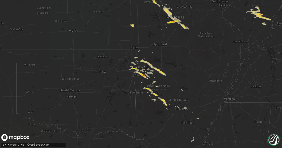
Hail Map on August 18, 2017
Get this storm
August 18 map
$229
one time, instant access
Download today. No call, no setup
Keep the $229
Bought the map and want the full workflow? Apply the entire $229 to a subscription within 7 days. None of it is wasted.
Every map, not just this one
This buys you this map. Subscription and you get every map we run, in the markets you choose from a few cities to whole states to nationwide. Plus real-time alerts the moment a storm fires.
Contact data
Name, contact info, occupancy, even credit band for addresses in the footprint. You go from where it hit to who to call.
Become the source they trust
Unlimited branding weather history reports on demand. You already have the documented answer ready for the property owner, and you are the one who showed up with it.
Property data and RoofTrace estimates
Pull up any address you have got, its value and the exact code rules for that jurisdiction, straight from One Click Code. Then RoofTrace estimates the squares, pitch, and roof value, priced the way you price.
States Impacted by Hail Map on August 18, 2017
Storm reports
South Dakota
| Date | Description |
|---|---|
| 08/18/20174:30 PM CDT | A local report indicates 1.00 inch wind near 2 WSW MORITZ |
| 08/18/20174:25 PM CDT | Several objects blown about 125 yards including a swing-set and trampoline. Estimated winds could have been around 70 mph. |
| 08/18/20174:07 PM CDT | 61 mph winds and quarter size hail. |
| 08/18/20173:51 PM CDT | A local report indicates 1.50 inch wind near 3 E ALBEE |
| 08/18/20173:06 PM CDT | Radar estimated time. |
| 08/18/20172:50 PM CDT | Mobile mesonet instruments measured the strong winds. |
| 08/18/20172:42 PM CDT | Report and video relayed through social media. Hail blanketed the entire u.s. Highway 12 roadway. |
| 08/18/20172:40 PM CDT | Report relayed through social media. |
| 08/18/20172:35 PM CDT | No damage apparent at time of call. |
Missouri
| Date | Description |
|---|---|
| 08/18/20176:51 PM CDT | A local report indicates 1.00 inch wind near LATHROP |
| 08/18/20176:50 PM CDT | A local report indicates 1.00 inch wind near 4 NE INDEPENDENCE |
| 08/18/20176:45 PM CDT | A local report indicates 1.50 inch wind near 1 S SMITHVILLE |
| 08/18/20175:34 PM CDT | Tree was blown over onto state highway 37. |
| 08/18/20171:07 AM CDT | Large tree fell on a small truck/pick up. Numerous trees and power lines down southeast of st. Robert and the devil's elbow area. Trees down on tulsa rd and transit rd. |
| 08/17/201710:00 PM CDT | A local report indicates 1.00 inch wind near KNOB NOSTER |
| 08/17/20179:48 PM CDT | Reported via social media. |
| 08/17/20179:44 PM CDT | Ping pong hail picture on social media near linn creek. |
| 08/17/20179:44 PM CDT | A local report indicates 1.25 inch wind near CAMDENTON |
| 08/17/20179:42 PM CDT | Near the intersection of ne 801st and 700th. |
| 08/17/20179:35 PM CDT | A local report indicates 1.00 inch wind near CAMDENTON |
| 08/17/20179:33 PM CDT | Reported via social media. Corrected for time. |
| 08/17/20179:20 PM CDT | Local media forwarded public report via social media. |
| 08/17/20179:15 PM CDT | Dime to quarter sized hail lasted for about 15 minutes starting at 915 pm cdt. |
| 08/17/20178:08 PM CDT | Delayed report... Picture showed approximately 2 inch hail on social media. |
| 08/17/20177:45 PM CDT | Local media forwarded public report via social media. |
New York
| Date | Description |
|---|---|
| 08/18/20176:57 PM CDT | Multiple trees down on simpson rd |
| 08/18/20176:57 PM CDT | Trees and wires down on dover road |
| 08/18/20176:57 PM CDT | Multiple trees down in road military rd near gauss rd |
| 08/18/20175:05 PM CDT | Tree down on ward street which brought down power lines. |
| 08/17/20177:02 PM CDT | Trees down on military rd near mill rd |
| 08/17/20177:02 PM CDT | Trees and wires down |
| 08/17/20177:02 PM CDT | Multiple trees down on russia road |
Virginia
| Date | Description |
|---|---|
| 08/18/20176:49 PM CDT | Asos station ofp... Hanover county municipal. |
| 08/18/20176:42 PM CDT | Trees down across northern essex county. Reports of wind debris in the road as far south as tappahannock. |
| 08/18/20176:21 PM CDT | Numerous trees down in sparta with damage to a home. |
| 08/18/20176:20 PM CDT | Numerous trees down across caroline county primarily in the central and eastern portions of the county. Numerous roads blocked by fallen trees. |
| 08/18/20176:05 PM CDT | Multiple trees knocked down across the roadway at the intersection of bath road and south river road. Time estimated from radar. |
| 08/17/20177:30 PM CDT | Few trees down across the county. |
| 08/17/20177:23 PM CDT | Trees down in southern king william county along highway 30. |
| 08/17/20177:12 PM CDT | A local report indicates 1.00 inch wind near WARSAW |
| 08/17/20177:10 PM CDT | Trees down along highway 360 and mill pond rd. |
Illinois
| Date | Description |
|---|---|
| 08/18/20176:48 PM CDT | Tree and power lines down. Time estimated by radar. |
| 08/18/20176:45 AM CDT | Estimated golf ball sized hail from public in wayne city |
| 08/18/20176:40 AM CDT | Reported via facebook. Time estimated by radar. |
| 08/18/20176:08 AM CDT | Quarter sized hail in carmi... With slightly larger hail just north of carmi. Late report. |
| 08/17/20178:14 PM CDT | Hail nearly covering ground. Largest was half dollar size. Time estimated by radar. |
Arkansas
| Date | Description |
|---|---|
| 08/18/20176:56 PM CDT | Extensive tree damage within neighborhood west of i-49 in fayetteville. Social media report with pics. |
| 08/18/20176:55 PM CDT | A local report indicates 1.25 inch wind near 6 SE FAYETTEVILLE |
| 08/18/20176:55 PM CDT | Stonebridge meadows subdivision. |
| 08/18/20176:53 PM CDT | A local report indicates 1.00 inch wind near FAYETTEVILLE |
| 08/18/20176:53 PM CDT | Power lines damaged near morningside drive and 15th street in fayetteville. Social media report. |
| 08/18/20176:42 PM CDT | Power poles broken. Tree limbs to 3 inches in diameter broken. |
| 08/18/20176:28 PM CDT | Power lines down on howard nickell road. |
| 08/18/20175:22 PM CDT | Social media report. |
| 08/17/20179:23 PM CDT | Trees were reported down on highway 27. |
| 08/17/20178:20 PM CDT | Trees and power lines were reported down on highway 22 in midway. |
| 08/17/20178:10 PM CDT | Trees and power lines were reported down and blocking highway 288 and highway 197. |
| 08/17/20177:55 PM CDT | Trees and power lines were reported down across cottontown road |
| 08/17/20177:40 PM CDT | Along i-40 between altus and ozark. |
| 08/17/20177:19 PM CDT | Tree branches to 3 inches in diameter broken. |
| 08/17/20177:13 PM CDT | Nws cooperative observer reports at least one tree blew over in their yard and estimated winds around 60 mph. |
| 08/17/20177:13 PM CDT | A local report indicates 1.75 inch wind near ELKINS |
| 08/17/20177:03 PM CDT | Reports a barn and power poles being blown down. |
Iowa
| Date | Description |
|---|---|
| 08/18/20176:39 PM CDT | Report via facebook |
| 08/17/201710:38 PM CDT | Trained spotter reported quarter sized hail lasting about 3-5 minutes... And some damage to vehicles. |
| 08/17/20179:21 PM CDT | Delayed report. Ef0 tornado surveyed 3 ese larrabee. Traveled 0.3 miles with a path width of 25 yards. Minor crop and tree damage. Tornado lifted at 9:27 pm. |
| 08/17/20179:20 PM CDT | Time estimated from radar. |
| 08/17/20179:20 PM CDT | Twisted trees... Corn flattened around 3 miles east... 1 mile south of larrabee. Time estimated from radar. |
| 08/17/20178:56 PM CDT | Time estimated from radar. |
| 08/17/20178:56 PM CDT | Time estimated from radar. |
| 08/17/20178:50 PM CDT | Farmstead damaged. No injuries. |
| 08/17/20178:44 PM CDT | Time estimated from radar. |
| 08/17/20178:44 PM CDT | Hail from 830pm to 845pm. Time of largest hail estimated from radar. |
| 08/17/20178:41 PM CDT | A local report indicates 1.00 inch wind near 2 W HARTLEY |
| 08/17/20178:30 PM CDT | Broadcast media relay of a public report. |
| 08/17/20178:14 PM CDT | Tractor trailer overturned on highway 60. |
| 08/17/20178:07 PM CDT | Ef2 tornado traveled 6 miles with a 250 yard wide path. The tornado lifted at 8:27 about a 1/2 mile southwest of melvin. |
| 08/17/20177:00 PM CDT | Mixture of dime to quarter size hail. |
New Jersey
| Date | Description |
|---|---|
| 08/18/20176:33 PM CDT | Downed tree on power lines on fort plains road |
| 08/18/20175:59 PM CDT | Trees down and power outages in mount laurel. Time estimated by radar. |
| 08/18/20175:45 PM CDT | Trees down near the waterfront in perth amboy and south amboy. Scattered wires and power lines down throughout the county. |
| 08/18/20175:45 PM CDT | Downed tree on us 206 between dunns mill road and us 130 intersection. All lanes closed. Time estimated from radar. |
| 08/18/20175:06 PM CDT | Downed trees and wires in the township. |
Pennsylvania
| Date | Description |
|---|---|
| 08/18/20175:32 PM CDT | Wires down in several locations. |
| 08/18/20175:15 PM CDT | Public report of high winds and flooding of low water crossings in yardley. Time estimated from radar. |
| 08/18/20174:54 PM CDT | Creek road at old york road closed from a downed tree in wires. Time estimated by radar. |
| 08/18/20174:40 PM CDT | Several trees down. |
| 08/18/20174:25 PM CDT | Downed tree in wires on clover mill road and pikeland road between kimberton road and church road. All lanes are closed. Time estimated by radar. |
| 08/18/20173:19 PM CDT | Tree down on wires on the 900 block of old topton road. Time estimated from radar. |
| 08/18/20172:47 PM CDT | Tree down at intersection of saddlebrook drive and daniel street in south heidelberg twp. Time estimated from radar. |
| 08/18/20172:25 PM CDT | Trees down along knight and red top road |
| 08/18/20172:12 PM CDT | Tree down at the 1400 block of old us route 22 in greenwich township. Time estimated from radar. |
| 08/18/201712:39 PM CDT | Structural damage to a house. |
Maryland
| Date | Description |
|---|---|
| 08/18/20176:51 PM CDT | Tree down on power lines near the intersection of new market turner road and hidden valley lane. |
| 08/18/20176:44 PM CDT | 2 trees down in chaptico. |
| 08/18/20176:08 PM CDT | Tree down in broomes island |
| 08/18/20175:52 PM CDT | Tree down near the intersection of old chapel road and waldorf way. |
| 08/18/20175:46 PM CDT | Tree down on power lines near the intersection of new market turner road and hidden valley lane. |
| 08/18/20175:00 PM CDT | Numerous large tree limbs down in the 7800 block of estevez road. |
| 08/18/20174:29 PM CDT | Tree limbs down near the arena club in churchville. |
| 08/18/20174:24 PM CDT | Several large tree branches down along sulphur spring rd between benson ave and railroad trussels |
| 08/18/20174:22 PM CDT | Large tree down onto vehicle along willys avenue between sulphur spring rd and june rd. No injuries. |
| 08/18/20174:22 PM CDT | Tree limb down on wires in the 1200 block of elm ridge avenue. |
| 08/18/20174:15 PM CDT | Several reports of trees down in the catonsville area. |
| 08/18/20174:11 PM CDT | Several large trees and limbs down in the 400 block of north hilton street. |
Minnesota
| Date | Description |
|---|---|
| 08/18/20176:45 PM CDT | Pea to quarter size hail. |
| 08/18/20176:45 PM CDT | A local report indicates 60 MPH wind near LAKE WILSON |
| 08/18/20176:40 PM CDT | A local report indicates 1.00 inch wind near 8 NNE JEFFERS |
| 08/18/20176:25 PM CDT | Trained storm spotter estimated winds gusting to 60 mph. |
| 08/18/20176:00 PM CDT | Quarter size hail and widespread road flooding reported in lynd via social media. |
| 08/18/20175:54 PM CDT | A local report indicates 1.00 inch wind near 1 E LAKE BENTON |
| 08/18/20175:35 PM CDT | Winds gusting to 67 mph in minneota along with pea size hail and torrential rain. |
| 08/18/201712:50 PM CDT | Brief quarter sized hail... Then down to dime sized hail |
| 08/18/201712:50 PM CDT | Brief quarter sized hail... Then down to dime sized hail |
| 08/17/20177:55 PM CDT | A local report indicates 2.00 inch wind near BIGELOW |
| 08/17/20177:47 PM CDT | Ef1 tornado traveled 1.97 miles with a 100 yard wide path. The tornado lifted at 7:54 about a mile southwest of bigelow. |
| 08/17/20177:47 PM CDT | Ef1 tornado traveled 1.97 miles with a 100 yard wide path. The tornado lifted at 7:54 about a mile southwest of bigelow. |
| 08/17/20177:46 PM CDT | Hog barn destroyed. |
| 08/17/20177:40 PM CDT | A local report indicates 1.75 inch wind near 5 SW WORTHINGTON |
| 08/17/20177:37 PM CDT | Ef 1 tornado tracked from 1 wnw of rushmore to 1 sw of rushmore. Tornado lifted at 7:43 pm. Path length was 1.25 miles with maximum width of 75 to 100 yards. Peak winds |
| 08/17/20177:26 PM CDT | Ef1 tornado traveled 1.6 miles with a 50 yard wide path. The tornado lifted at 7:35 just southwest of rushmore. |
| 08/17/20177:20 PM CDT | A local report indicates 1.50 inch wind near 2 S WILMONT |
Florida
| Date | Description |
|---|---|
| 08/18/20175:35 PM CDT | Emergency manager reports 1 roof damaged on buckingham ct and 1 car port damaged on green road in rockledge. Time approximate. Possible tornado. Re-sent for correction. |
Cities Impacted by Hail Map on August 18, 2017
- Effie, MN
- Walnut Hill, IL
- Dix, IL
- Centralia, IL
- Barnett, MO
- Stover, MO
- Versailles, MO
- Johnsonville, IL
- Iuka, IL
- Coatsville, MO
- Camdenton, MO
- Lynd, MN
- Wadena, MN
- Wayne City, IL
- Keenes, IL
- Bluford, IL
- Sanborn, MN
- Lamberton, MN
- Revillo, SD
- Chandler, MN
- Lake Wilson, MN
- Sanborn, IA
- Altus, AR
- Casa, AR
- Ola, AR
- Dardanelle, AR
- Danville, AR
- Milbank, SD
- Twin Brooks, SD
- Elkins, AR
- Fayetteville, AR
- Burlington, IA
- Marietta, MN
- Aurelia, IA
- Alta, IA
- Peterson, IA
- Ocheyedan, IA
- Hartley, IA
- Sibley, IA
- Reading, MN
- Iona, MN
- Primghar, IA
- Slayton, MN
- Galva, IA
- Wilmont, MN
- Cherokee, IA
- Melvin, IA
- Worthington, MN
- Schaller, IA
- Rushmore, MN
- Sutherland, IA
- Bigelow, MN
- Larrabee, IA
- Brandt, SD
- Gary, SD
- Strandburg, SD
- Clear Lake, SD
- Canby, MN
- Warrensburg, MO
- Centerview, MO
- Odessa, MO
- Sulphur Springs, AR
- South West City, MO
- Washburn, MO
- Carmi, IL
- Springerton, IL
- Enfield, IL
- Sunrise Beach, MO
- Kaiser, MO
- Linn Creek, MO
- Osage Beach, MO
- Monticello, AR
- Gorin, MO
- Winslow, AR
- Holland, MN
- Ruthton, MN
- Mora, MO
- Cole Camp, MO
- Gravois Mills, MO
- Rocky Mount, MO
- Richards, MO
- Mechanicsville, MD
- Charlotte Hall, MD
- Hopedale, IL
- Stanford, IL
- Armington, IL
- Fifty Lakes, MN
- Crosslake, MN
- Emily, MN
- Jasper, AR
- Green Forest, AR
- Berryville, AR
- Harrison, AR
- Marble Falls, AR
- Alpena, AR
- Maysville, AR
- Jay, OK
- McLean, IL
- Minier, IL
- La Monte, MO
- Higginsville, MO
- Mayview, MO
- Bates City, MO
- Whiteman Air Force Base, MO
- Concordia, MO
- Knob Noster, MO
- Green Ridge, MO
- Oak Grove, MO
- Napoleon, MO
- Richmond, MO
- Lexington, MO
- Schwenksville, PA
- Garfield, AR
- Rogers, AR
- Laurel, MD
- Burtonsville, MD
- Beltsville, MD
- Newmanstown, PA
- Pinckneyville, IL
- Tamaroa, IL
- Fortuna, MO
- Bumpass, VA
- Beaverdam, VA
- Welcome, MD
- La Plata, MD
- Port Tobacco, MD
- Port Republic, MD
- Newburg, MD
- Prince Frederick, MD
- Faulkner, MD
- Bel Alton, MD
- Hughesville, MD
- Chaptico, MD
- Iberia, MO
- Gary, MN
- Twin Valley, MN
- Fort Meade, FL
- Bowling Green, FL
- Montreal, MO
- Alexandria, MO
- Saint Patrick, MO
- Atchison, KS
- Cummings, KS
- Joppa, MD
- Kingsville, MD
- Middle River, MD
- Rosedale, MD
- Edgewood, MD
- Nottingham, MD
- Parkville, MD
- Sparrows Point, MD
- Baltimore, MD
- Upper Falls, MD
- Perry Hall, MD
- White Marsh, MD
- Rock Hall, MD
- Gunpowder, MD
- Glen Arm, MD
- Essex, MD
- Dundalk, MD
- Jacksonville, NC
- Little Rock, AR
- Windom, MN
- Fulda, MN
- Reading, PA
- Bryantown, MD
- Brandywine, MD
- Waldorf, MD
- Aquasco, MD
- Havana, AR
- Kansas City, MO
- Dryden, TX
- Lomax, IL
- Bonnie, IL
- Belle Rive, IL
- Independence, MO
- Corder, MO
- Alma, MO
- Dover, MO
- Waverly, MO
- Norborne, MO
- Gentry, MO
- Galesburg, IL
- Knoxville, IL
- Lake Benton, MN
- Orrick, MO
- Roach, MO
- Macks Creek, MO
- Brumley, MO
- Georgetown, DE
- Forest Hill, MD
- Bel Air, MD
- Fallston, MD
- Punta Gorda, FL
- Carrollton, MO
- Saint Robert, MO
- Crocker, MO
- Waynesville, MO
- Fort Leonard Wood, MO
- Platte City, MO
- Grain Valley, MO
- Buckner, MO
- Liberty, MO
- Florence, MO
- Otterville, MO
- Monmouth, IL
- Cameron, IL
- Chesterfield, VA
- Lawson, MO
- Opdyke, IL
- Fort Scott, KS
- Glenn Dale, MD
- Lanham, MD
- Bowie, MD
- Norris City, IL
- Broughton, IL
- McLeansboro, IL
- Merrifield, MN
- Brainerd, MN
- Round Lake, MN
- Madison, MN
- Powell, MO
- Eureka Springs, AR
- Pineville, MO
- Seligman, MO
- Richmond, VA
- Mohrsville, PA
- Bernville, PA
- Leesport, PA
- Amelia Court House, VA
- Church Road, VA
- Mount Vernon, IL
- Crossville, IL
- Richview, IL
- Texico, IL
- Hoyleton, IL
- Woodlawn, IL
- Dahlgren, IL
- Gentry, AR
- New Bloomfield, MO
- Media, IL
- Smithshire, IL
- Makinen, MN
- Aurora, MN
- Paton, IA
- Farnhamville, IA
- Somers, IA
- Rockwell City, IA
- Gowrie, IA
- Siloam Springs, AR
- Terril, IA
- Noel, MO
- Gravette, AR
- Hardin, MO
- Adrian, MN
- Redwood Falls, MN
- Belview, MN
- Deerfield, MO
- Niota, IL
- Fort Madison, IA
- West Point, IA
- Donnellson, IA
- Wever, IA
- Menahga, MN
- Goodman, MO
- Anderson, MO
- Smithville, MO
- Ogema, MN
- Callaway, MN
- Tremont, IL
- Pekin, IL
- Green Valley, IL
- Weston, MO
- Ozark, AR
- Carlisle, AR
- England, AR
- Belleville, AR
- Perryville, AR
- Colcord, OK
- Millersville, PA
- Conestoga, PA
- Currie, MN
- Avoca, MN
- Carson, VA
- Dewitt, VA
- Stony Creek, VA
- Dinwiddie, VA
- Polo, MO
- Pasadena, MD
- Bluffton, MN
- Oley, PA
- Hightstown, NJ
- Cranbury, NJ
- Princeton Junction, NJ
- Richland, MO
- Reinholds, PA
- Wernersville, PA
- Minneota, MN
- Dale, IL
- Subiaco, AR
- New Blaine, AR
- Scranton, AR
- Delavan, IL
- Wesley, AR
- Huntsville, AR
- Hindsville, AR
- Cherry Hill, NJ
- Quarryville, PA
- Peach Bottom, PA
- Kirkwood, PA
- Nottingham, PA
- Roland, AR
- Plymouth, IL
- Littleton, IL
- Rayville, MO
- Balaton, MN
- Pequot Lakes, MN
- Brodnax, VA
- Hendricks, MN
- Dallas City, IL
- Carthage, IL
- Philadelphia, PA
- Jarrettsville, MD
- Lathrop, MO
- Tyler, MN
- Princeton, NJ
- Floriston, CA
- Holtwood, PA
- Upper Marlboro, MD
- Witter, AR
- Comstock, TX
- Ulman, MO
- Taunton, MN
- Porter, MN
- Jeffers, MN
- Lake Ozark, MO
- Newburg, MO
- Dixon, MO
- Smithton, MO
- Devils Elbow, MO
- Duke, MO
- Dana, IA
- Pomeroy, IA
- Manson, IA
- Woodstock, MN
- Dearborn, MO
- Stewartsville, MO
- Gower, MO
- Robesonia, PA
- Womelsdorf, PA
- Street, MD
- Baldwin, MD
- Hughesville, MO
- Hydes, MD
- White Hall, MD
- Silver Spring, MD
- Paullina, IA
- Ashton, IA
- White, SD
- Calumet, IA
- Elkton, SD
- Garvin, MN
- Big Falls, MN
- Coal Hill, AR
- Pettigrew, AR
- Oark, AR
- Deer, AR
- Hewitt, MN
- Henning, MN
- Deer Creek, MN
- Felton, MN
- Annville, PA
- Palmyra, PA
- Hershey, PA
- Taylors Island, MD
- Bellingham, MN
- Western Grove, AR
- Hasty, AR
- Compton, AR
- Mohnton, PA
- Birdsboro, PA
- Dahlgren, VA
- King George, VA
- Arcadia, FL
- Ruther Glen, VA
- Salem, IA
- Turney, MO
- Braymer, MO
- Henrietta, MO
- Cowgill, MO
- Plattsburg, MO
- Douglassville, PA
- Granby, MO
- Rolfe, IA
- Bradgate, IA
- Ottosen, IA
- Glen Burnie, MD
- Curtis Bay, MD
- Canton, IL
- Topeka, IL
- South Pekin, IL
- Manito, IL
- Springdale, AR
- Gibson Island, MD
- Annapolis, MD
- Arnold, MD
- Westbrook, MN
- Kell, IL
- Sherwood, AR
- Jacksonville, AR
- Scott, AR
- North Little Rock, AR
- Edgewater, MD
- Immokalee, FL
- Naples, FL
- Powhatan, VA
- Arco, MN
- Ivanhoe, MN
- Edgerton, MO
- Trimble, MO
- Magazine, AR
- Paris, AR
- Kahoka, MO
- Clarksville, AR
- Ozone, AR
- Lowell, AR
- Dickens, IA
- Ayrshire, IA
- Mallard, IA
- Emmetsburg, IA
- Ruthven, IA
- Mulberry, AR
- Brogue, PA
- Airville, PA
- Barto, PA
- Pennsburg, PA
- Bechtelsville, PA
- Churchville, MD
- Livonia, MO
- Lancaster, MO
- Wellington, MO
- Robertsdale, AL
- Capitol Heights, MD
- Hartman, AR
- Labolt, SD
- Goodwin, SD
- Astoria, SD
- Heron Lake, MN
- Ona, FL
- Midlothian, VA
- Stevensville, MD
- Hollandale, MS
- Trappe, MD
- Echo, MN
- Park Rapids, MN
- Exeter, MO
- Neosho, MO
- Aledo, IL
- Alexis, IL
- Brooklyn, MD
- Halethorpe, MD
- Half Way, MO
- Ratcliff, AR
- Columbia, MD
- Ellicott City, MD
- Marshall, MN
- Ghent, MN
- Russell, MN
- Wyaconda, MO
- Borup, MN
- Easton, MD
- West Bend, IA
- Nisswa, MN
- Almyra, AR
- Stuttgart, AR
- Humphrey, AR
- Laurel, DE
- Nanjemoy, MD
- Gambrills, MD
- Odenton, MD
- Millersville, MD
- Callahan, FL
- Catonsville, MD
- Elkridge, MD
- Bella Vista, AR
- Zolfo Springs, FL
- Wauchula, FL
- Bowen, IL
- Augusta, IL
- Chestertown, MD
- Sedalia, MO
- Woodford, VA
- Manheim, PA
- Lititz, PA
- Pylesville, MD
- Delta, PA
- Whiteford, MD
- Lismore, MN
- Ford, VA
- Crane, MO
- Monkton, MD
- Sparks Glencoe, MD
- Willow Street, PA
- New Providence, PA
- Pequea, PA
- Lancaster, PA
- Tunas, MO
- Easton, KS
- Pinecrest, CA
- Quitman, AR
- Bee Branch, AR
- Excelsior Springs, MO
- Akron, PA
- Leola, PA
- Ephrata, PA
- New Holland, PA
- Bird In Hand, PA
- Combs, AR
- Decatur, AR
- Bentonville, AR
- Sweet Springs, MO
- Houstonia, MO
- Bertha, MN
- Eagle Bend, MN
- Parkers Prairie, MN
- Carman, IL