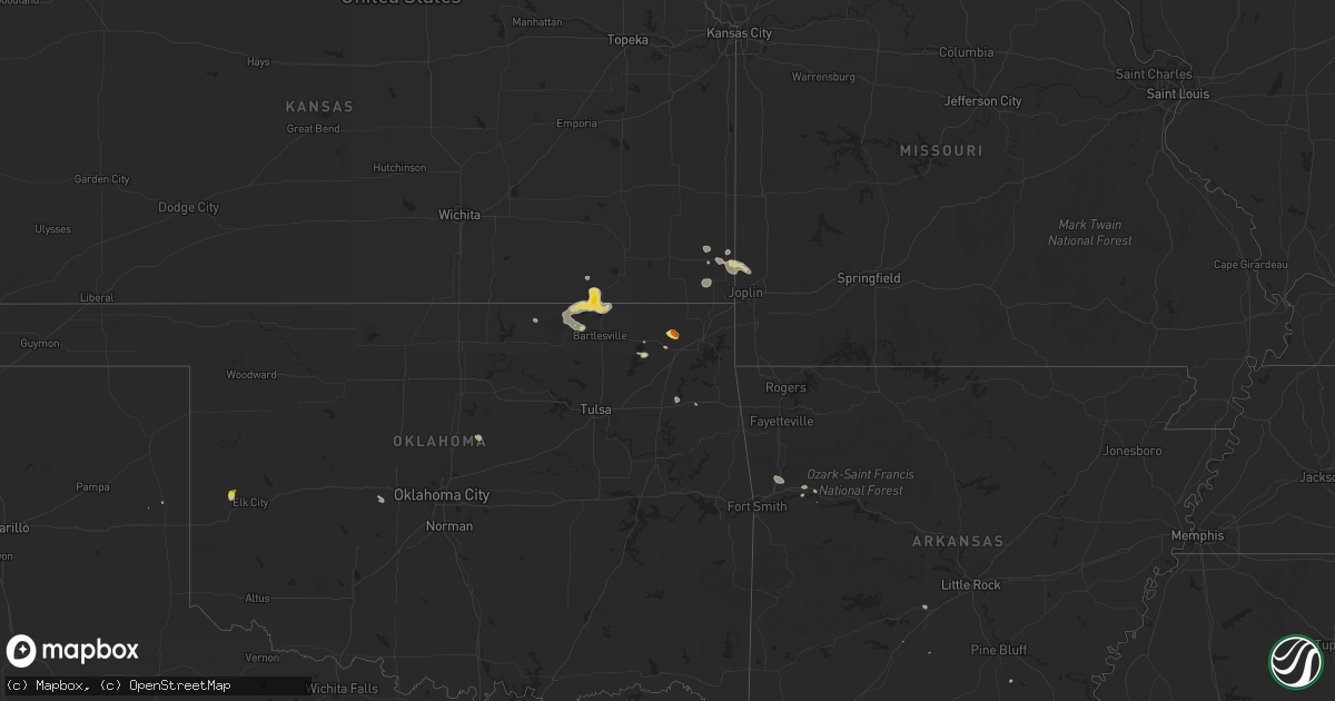
Hail Map on August 16, 2022
Get this storm
August 16 map
$229
one time, instant access
Download today. No call, no setup
Keep the $229
Bought the map and want the full workflow? Apply the entire $229 to a subscription within 7 days. None of it is wasted.
Every map, not just this one
This buys you this map. Subscription and you get every map we run, in the markets you choose from a few cities to whole states to nationwide. Plus real-time alerts the moment a storm fires.
Contact data
Name, contact info, occupancy, even credit band for addresses in the footprint. You go from where it hit to who to call.
Become the source they trust
Unlimited branding weather history reports on demand. You already have the documented answer ready for the property owner, and you are the one who showed up with it.
Property data and RoofTrace estimates
Pull up any address you have got, its value and the exact code rules for that jurisdiction, straight from One Click Code. Then RoofTrace estimates the squares, pitch, and roof value, priced the way you price.
States Impacted by Hail Map on August 16, 2022
Storm reports
Florida
| Date | Description |
|---|---|
| 08/16/202212:50 PM CDT | Spotter reported trees down on 8000 block of hickory grove rd. |
| 08/16/202212:40 PM CDT | Spotter reported downed trees on hwy-145 just south of dusty miller ave. |
| 08/16/202212:15 PM CDT | Media reported a downed tree on fontaine drive between piedmont dr and live oak plantation rd. |
| 08/16/202212:12 PM CDT | Tree on eastbound land of centerville road near pimlico drive. |
| 08/15/202210:47 PM CDT | At 347 PM CDT, a severe thunderstorm was located 5 miles northeast of Navarre Beach, or 7 miles west of Mary Esther, moving southeast at 10 mph. HAZARD...60 mph wind gusts and quarter size hail. SOURCE...Radar indicated. IMPACT...Hail damage to vehicles is expected. Expect wind damage to roofs, siding, and trees. Locations impacted include... Navarre Beach. |
| 08/15/202210:31 PM CDT | At 330 PM CDT, severe thunderstorms were located along a line extending from Eglin Air Force Base to 11 miles northwest of Panama City Beach, moving south at 15 mph. HAZARD...60 mph wind gusts and penny size hail. SOURCE...Radar indicated. IMPACT...Expect damage to roofs, siding, and trees. Locations impacted include... Santa Rosa Beach, Eglin Air Force Base, Freeport, Inlet Beach, Portland, Port Washington, Blue Mountain Beach, Seaside, Gulf Pines, New Home, Bunker, Grayton Beach, Seagrove Beach, Sandestin and Four Mile Village. |
| 08/15/20229:38 PM CDT | At 238 PM CDT, a severe thunderstorm was located 12 miles southeast of De Funiak Springs, moving southeast at 10 mph. HAZARD...60 mph wind gusts and penny size hail. SOURCE...Radar indicated. IMPACT...Expect damage to roofs, siding, and trees. Locations impacted include... Eucheeanna, Knox Hill and Red Bay. |
| 08/15/20229:06 PM CDT | At 206 PM EDT, severe thunderstorms were located along a line extending from 13 miles southwest of Monticello to 10 miles east of Woodville, moving east at 25 mph. HAZARD...60 mph wind gusts. SOURCE...Radar indicated. IMPACT...Expect damage to roofs, siding, and trees. Locations impacted include... Woodville, Cody, Goose Pasture, Hells Half Acre, Fanlew, Wacissa, Wacissa Springs, Natural Bridge, Cabbage Grove, Thomas City and Econfina. |
| 08/15/20228:59 PM CDT | At 159 PM CDT, a severe thunderstorm was located near Bonifay, moving southeast at 10 mph. HAZARD...60 mph wind gusts and penny size hail. SOURCE...Radar indicated. IMPACT...Expect damage to roofs, siding, and trees. Locations impacted include... Vernon, Chipley, Bradford, Wausau, Brock Crossroad, Chipley Municipal Airport, Orange Hill, Whitehead Crossroads, Five Points, Smyrna, Spring Hollow, Sunny Hills, Poplar Head, Sylvania and Johnson Crossroads. |
Kansas
| Date | Description |
|---|---|
| 08/16/20226:45 PM CDT | Cooperative observer estimated winds of 60 mph and visibility reduced to 100 yards from the rain. |
| 08/16/20221:59 AM CDT | At 659 PM CDT, severe thunderstorms were located along a line extending from near Caney to near Hulah, moving northeast at 20 mph. HAZARD...60 mph wind gusts and quarter size hail. SOURCE...Radar indicated. IMPACT...Hail damage to vehicles is expected. Expect wind damage to roofs, siding, and trees. Locations impacted include... Coffeyville, Caney, Dearing, Tyro, Peru, Liberty, Havana, Niotaze, Independence Airport and Coffeyville Airport. |
| 08/16/20221:58 AM CDT | At 657 PM CDT, a severe thunderstorm was located 3 miles northeast of Copan, moving east at 15 mph. HAZARD...60 mph wind gusts and quarter size hail. SOURCE...Radar indicated. IMPACT...Hail damage to vehicles is expected. Expect wind damage to roofs, siding, and trees. Locations in or near the path include... South Coffeyville... Copan... Lenapah... Wann... Hulah... Wah Sha She State Park... |
Colorado
| Date | Description |
|---|---|
| 08/15/202211:40 PM CDT | At 440 PM MDT, a severe thunderstorm was located 7 miles east of Blue Lake, or 28 miles northeast of North La Junta, moving southeast at 15 mph. HAZARD...60 mph wind gusts and quarter size hail. SOURCE...Radar indicated. IMPACT...Hail damage to vehicles is expected. Expect wind damage to roofs, siding, and trees. Locations impacted include... Blue Lake. |
Oklahoma
| Date | Description |
|---|---|
| 08/16/20222:31 AM CDT | At 730 PM CDT, a severe thunderstorm was located 9 miles west of Elk City, and is nearly stationary, but the winds from the storm will spread out. HAZARD...60 mph wind gusts and half dollar size hail. SOURCE...Radar indicated. IMPACT...Hail damage to vehicles is expected. Expect wind damage to roofs, siding, and trees. Locations impacted include... The west side of Elk City, and Berlin. |
| 08/16/20222:18 AM CDT | At 717 PM CDT, a severe thunderstorm was located 4 miles southwest of Perkins. The storm was moving east at 15 mph, but additional thunderstorms were developing to the west. HAZARD...60 mph wind gusts and quarter size hail. SOURCE...Radar indicated. IMPACT...Hail damage to vehicles is expected. Expect wind damage to roofs, siding, and trees. Locations impacted include... Perkins, Langston, Tryon, Ripley and Coyle. |
| 08/16/202212:33 AM CDT | At 533 PM CDT, a severe thunderstorm was located 7 miles west of Bluejacket, moving east at 10 mph. HAZARD...60 mph wind gusts and nickel size hail. SOURCE...Radar indicated. IMPACT...Expect damage to roofs, siding, and trees. Locations in or near the path include... Bluejacket... Pyramid Corners...This includes Interstate 44 between mile markers 288 and 290. |
| 08/15/20227:55 PM CDT | Power pole snapped. Numerous small to medium tree limbs downed. Photos via social media. Time estimated by radar. |
| 08/15/20227:09 PM CDT | Several large tree limbs down. Winds estimated at 60 to 65 mph. Time estimated by radar. |
Arizona
| Date | Description |
|---|---|
| 08/16/20226:54 AM CDT | At 1153 AM MST, a severe thunderstorm was located over Vernon, or 21 miles east of Show Low, moving northwest at 10 mph. HAZARD...Quarter size hail. SOURCE...Radar indicated. IMPACT...Damage to vehicles is expected. Locations impacted include... Vernon. |
| 08/16/20224:40 AM CDT | At 939 PM MST, a severe thunderstorm was located near Kartchner Caverns State Park, or 9 miles southwest of Benson, moving southwest at 25 mph. HAZARD...60 mph wind gusts and quarter size hail. SOURCE...Radar indicated. IMPACT...Hail damage to vehicles is expected. Expect wind damage to roofs, siding, and trees. Locations impacted include... Kartchner Caverns State Park. |
| 08/16/20221:29 AM CDT | At 628 PM MST, a severe thunderstorm was located over Casas Adobes, or near Oro Valley, and is nearly stationary. HAZARD...60 mph wind gusts, quarter size hail and brief heavy rain. SOURCE...Radar indicated. IMPACT...Hail damage to vehicles is expected. Expect wind damage to roofs, siding, and trees. Locations impacted include... Oro Valley, Marana, Casas Adobes, Flowing Wells and Tortolita. |
| 08/16/20221:14 AM CDT | At 613 PM MST, a severe thunderstorm was located 9 miles west of Benson, moving west at 5 mph. HAZARD...60 mph wind gusts, quarter size hail and brief heavy rain. SOURCE...Radar indicated. IMPACT...Hail damage to vehicles is expected. Expect wind damage to roofs, siding, and trees. Locations impacted include... Mescal. |
| 08/16/202212:42 AM CDT | At 542 PM MST, severe thunderstorms were located along a line extending from near Kinter to near Ligurta to 13 miles southeast of Fortuna Foothills, and are nearly stationary. HAZARD...60 mph wind gusts. SOURCE...Radar indicated. IMPACT...Expect damage to roofs, siding, and trees. Locations impacted include... Fortuna Foothills, Wellton, Blaisdell, Ligurta and Kinter. This includes the following highways...AZ Interstate 8 between mile markers 11 and 29.AZ Route 95 between mile markers 33 and 44. |
| 08/15/202210:55 PM CDT | At 354 PM MST, a severe thunderstorm was located over Window Rock, moving northwest at 15 mph. HAZARD...60 mph wind gusts and quarter size hail. SOURCE...Radar indicated. IMPACT...Hail damage to vehicles is expected. Expect wind damage to roofs, siding, and trees. Locations impacted include... Fort Defiance, Window Rock and St. Michaels. |
| 08/15/202210:23 PM CDT | At 322 PM MST, a severe thunderstorm was located 13 miles southwest of Woodruff, or 32 miles north of Show Low, moving northeast at 15 mph. HAZARD...Quarter size hail. SOURCE...Radar indicated. IMPACT...Damage to vehicles is expected. This severe thunderstorm will remain over mainly rural areas of Navajo County. |
| 08/15/202210:22 PM CDT | At 322 PM MST, a severe thunderstorm was located 13 miles southwest of Woodruff, or 32 miles north of Show Low, moving northeast at 15 mph. HAZARD...Quarter size hail. SOURCE...Radar indicated. IMPACT...Damage to vehicles is expected. This severe thunderstorm will remain over mainly rural areas of Navajo County. |
| 08/15/20228:37 PM CDT | Major tree limbs down and flooding. |
California
| Date | Description |
|---|---|
| 08/16/20224:27 PM CDT | Thunderstorm winds flipped 4 semis on i-10. |
| 08/15/20229:32 PM CDT | At 232 PM PDT, a severe thunderstorm was located 17 miles northeast of Brawley, and is nearly stationary. HAZARD...60 mph wind gusts and penny size hail. SOURCE...Radar indicated. IMPACT...Expect damage to roofs, siding, and trees. Locations impacted include... Calipatria and Wiest. This includes CA Route 111 between mile markers 32 and 34. |
| 08/15/20228:40 PM CDT | At 140 PM PDT, a severe thunderstorm was located over Cottonwood Visitor, or 8 miles northwest of Chiriaco Summit, moving northwest at 5 mph. HAZARD...60 mph wind gusts and penny size hail. SOURCE...Radar indicated. IMPACT...Expect damage to roofs, siding, and trees. Locations impacted include... Chiriaco Summit and Cottonwood Visitor. This includes CA Interstate 10 between mile markers 74 and 102. |
Mississippi
| Date | Description |
|---|---|
| 08/16/20226:05 PM CDT | Tree downed along howard st in belhaven. |
| 08/16/20225:51 PM CDT | Tree downed onto utility equipment. |
| 08/16/20223:40 PM CDT | Strong wind gusts and downed trees resulting in utility damage. |
| 08/16/20223:29 PM CDT | Trees downed in the toomsuba area... With power lines downed along northshore dr. Reports via social media. |
| 08/16/20221:40 AM CDT | At 640 PM CDT, a severe thunderstorm was located over Brandon, moving southeast at 20 mph. HAZARD...60 mph wind gusts and quarter size hail. SOURCE...Radar indicated. IMPACT...Hail damage to vehicles is expected. Expect wind damage to roofs, siding, and trees. Locations impacted include... Jackson, Brandon and Monterey. |
| 08/16/202212:35 AM CDT | At 535 PM CDT, a severe thunderstorm was located near Myrick, or 10 miles east of Laurel, and is nearly stationary. HAZARD...60 mph wind gusts and quarter size hail. SOURCE...Radar indicated. IMPACT...Hail damage to vehicles is expected. Expect wind damage to roofs, siding, and trees. Locations impacted include... Mill Creek. |
| 08/15/202211:00 PM CDT | At 400 PM CDT, a severe thunderstorm was located 5 miles north of Citronelle, moving south at 25 mph. HAZARD...60 mph wind gusts and quarter size hail. SOURCE...Radar indicated. IMPACT...Hail damage to vehicles is expected. Expect wind damage to roofs, siding, and trees. Locations impacted include... Saraland, Satsuma, Citronelle, Chunchula, Gulfcrest and Deer Park. |
| 08/15/202210:23 PM CDT | At 323 PM CDT, severe thunderstorms were located along a line extending from near Marion to Toomsuba, moving southeast at 20 mph. HAZARD...60 mph wind gusts and nickel size hail. SOURCE...Radar indicated. IMPACT...Expect damage to roofs, siding, and trees. Locations impacted include... Lauderdale, Meridian, Meridian Station, Marion, Alamucha, Toomsuba and Kewanee. |
| 08/15/202210:21 PM CDT | At 321 PM CDT, severe thunderstorms were located along a line extending from near Thomastown to Dowdville, moving southeast at 15 mph. HAZARD...60 mph wind gusts and nickel size hail. SOURCE...Radar indicated. IMPACT...Expect damage to roofs, siding, and trees. Locations impacted include... Carthage, Prospect, Dowdville, Tuscola, Madden, Dixon, Walnut Grove, Sebastopol, Lena, Redwater and Standing Pine. |
New York
| Date | Description |
|---|---|
| 08/16/20223:27 PM CDT | Tree down. |
| 08/16/20223:12 PM CDT | A local report indicates 0 MPH wind near MANCHESTER |
| 08/16/20223:12 PM CDT | Tree down. |
| 08/16/20221:40 PM CDT | Tree down on house. Time based on radar. |
| 08/15/202211:02 PM CDT | At 401 PM EDT, a severe thunderstorm was located near Canandaigua, moving west at 15 mph. HAZARD...60 mph wind gusts and quarter size hail. SOURCE...Radar indicated. IMPACT...Minor damage to vehicles is possible. Expect wind damage to trees and power lines. Locations impacted include... Canandaigua, Bristol, Clifton Springs, Bloomfield, Gorham, East Bloomfield, Manchester, Shortsville, Cheshire and Cottage City. |
Arkansas
| Date | Description |
|---|---|
| 08/15/202211:44 PM CDT | At 444 PM CDT, a severe thunderstorm was located over Star City, moving east at 5 mph. HAZARD...60 mph wind gusts and penny size hail. SOURCE...Radar indicated. IMPACT...Expect damage to roofs, siding, and trees. Locations impacted include... Star City... Nebo... Feenyville... Cane Creek State Park... Garrett Bridge... Calhoun... Tyro... Rose Hill... Crigler... Fresno... Garnett... Avery... Yorktown... Palmyra... |
| 08/15/202211:16 PM CDT | At 416 PM CDT, a severe thunderstorm was located over Star City, moving northeast at 10 mph. HAZARD...60 mph wind gusts and quarter size hail. SOURCE...Radar indicated. IMPACT...Hail damage to vehicles is expected. Expect wind damage to roofs, siding, and trees. Locations impacted include... Star City... Nebo... Feenyville... Cane Creek State Park... Glendale in Lincoln County... Tarry... Fresno... Calhoun... Cornerville... Palmyra... Crigler... Yorktown... |
| 08/15/202211:01 PM CDT | At 401 PM CDT, a severe thunderstorm was located near Mt Elba, or near Rison, moving southeast at 20 mph. HAZARD...60 mph wind gusts and penny size hail. SOURCE...Radar indicated. IMPACT...Expect damage to roofs, siding, and trees. Locations impacted include... Kingsland... Mt Elba... Tipton... Marks Mill State Park... Hebron... Toledo... Herbine... Rowell... Calmer... Orlando... Pansy... New Edinburg... Rye... |
| 08/15/202210:46 PM CDT | At 346 PM CDT, a severe thunderstorm was located near Rison, moving east at 15 mph. HAZARD...60 mph wind gusts and penny size hail. SOURCE...Radar indicated. IMPACT...Expect damage to roofs, siding, and trees. Locations impacted include... Rison... Kingsland... Mt Elba... Toledo... Kedron... Staves... Mt Zion... |
| 08/15/202210:38 PM CDT | At 338 PM CDT, a severe thunderstorm was located near Poyen, or 10 miles east of Malvern, moving east at 15 mph. HAZARD...60 mph wind gusts and penny size hail. SOURCE...Radar indicated. IMPACT...Expect damage to roofs, siding, and trees. Locations impacted include... Sheridan... Traskwood... Tull... Prattsville... Poyen... Thiel... Jenkins Ferry State Park... Dogwood... Belfast... Fenter... Gifford... Glen Rose... Buie... |
| 08/15/202210:36 PM CDT | At 336 PM CDT, a severe thunderstorm was located over Arkansas City, or 11 miles south of Rohwer, moving east at 5 mph. HAZARD...60 mph wind gusts and penny size hail. SOURCE...Radar indicated. IMPACT...Expect damage to roofs, siding, and trees. Locations impacted include... Arkansas City... Jersey Point... |
| 08/15/202210:30 PM CDT | At 329 PM CDT, a severe thunderstorm was located near Stonehouse Recreation Area, or 14 miles southwest of Danville, moving southeast at 10 mph. HAZARD...60 mph wind gusts. SOURCE...Radar indicated. IMPACT...Expect damage to roofs, siding, and trees. Locations impacted include... Gravelly... Fourche Valley... Muddy Creek WMA... Rover... Wing... Chula... Macedonia in Yell County... Waltreak... Bluffton... Fourche Mountain Recreation Are... Briggsville... Blue Ball... |
| 08/15/202210:22 PM CDT | At 321 PM CDT, a severe thunderstorm was located near Herbine, or 9 miles southwest of Star City, moving southeast at 10 mph. Additional severe thunderstorms were located across northern Drew County, also moving southeast at 10 mph. HAZARD...60 mph wind gusts and penny size hail. SOURCE...Radar indicated. IMPACT...Expect damage to roofs, siding, and trees. Locations impacted include... Monticello... Star City... Plantersville... Cane Creek State Park... Brandon... Mt Elba... Herbine... Garrett Bridge... Gourd... Cornerville... Florence... Tyro... Palmyra... Rose Hill... Crigler... Selma... Montongo... Relfs Bluff... Rye... Glendale in Lincoln County... |
| 08/15/202210:07 PM CDT | At 307 PM CDT, a severe thunderstorm was located over Prattsville, or near Sheridan, moving east at 20 mph. HAZARD...60 mph wind gusts and penny size hail. SOURCE...Radar indicated. IMPACT...Expect damage to roofs, siding, and trees. Locations impacted include... Sheridan... Prattsville... Jenkins Ferry State Park... Thiel... Dogwood... Ain... Buie... Cross Roads in Grant County... Center Grove... Grapevine... Slabtown... Millerville... |
| 08/15/202210:02 PM CDT | At 302 PM CDT, a severe thunderstorm was located near Rockport, or 7 miles northwest of Malvern, moving southeast at 10 mph. HAZARD...60 mph wind gusts and penny size hail. SOURCE...Radar indicated. IMPACT...Expect damage to roofs, siding, and trees. Locations impacted include... Malvern... Rockport... Traskwood... Tull... Poyen... Perla... Thiel... Jenkins Ferry State Park... Magnet Cove... Lono... Fenter... Gifford... Glen Rose... Buie... Lake Catherine State Park... Brush Creek... |
| 08/15/20229:41 PM CDT | At 240 PM CDT, a severe thunderstorm was located 9 miles southwest of Winchester, or 11 miles northeast of Monticello, moving southeast at 15 mph. HAZARD...60 mph wind gusts and penny size hail. SOURCE...Radar indicated. IMPACT...Expect damage to roofs, siding, and trees. Locations impacted include... Tillar... McGehee... Reed... Collins... Florence... Selma... Enon... |
| 08/15/20229:38 PM CDT | At 238 PM CDT, a severe thunderstorm was located near Benton, moving east at 20 mph. HAZARD...60 mph wind gusts and penny size hail. SOURCE...Radar indicated. IMPACT...Expect damage to roofs, siding, and trees. Locations impacted include... Benton... Bryant... Haskell... Shannon Hills... Traskwood... Tull... Lonsdale... Salem in Saline County... East End... Alexander... Bauxite... Avilla... Fenter... Nance... Shaw... Congo... Glen Rose... Vimy Ridge... Grape... Bland... |
| 08/15/20229:34 PM CDT | At 234 PM CDT, a severe thunderstorm was located over Leola, or 14 miles southwest of Sheridan, moving southeast at 20 mph. HAZARD...60 mph wind gusts and penny size hail. SOURCE...Radar indicated. IMPACT...Expect damage to roofs, siding, and trees. Locations impacted include... Leola... Carthage... Thiel... Jenkins Ferry State Park... Dogwood... Ain... Lono... Cross Roads in Grant County... Tulip... Farindale... Bunn... Willow... Grapevine... Brush Creek... Millerville... |
| 08/15/20229:07 PM CDT | At 207 PM CDT, a severe thunderstorm was located 9 miles southwest of Malvern, moving southeast at 15 mph. HAZARD...60 mph wind gusts and penny size hail. SOURCE...Radar indicated. IMPACT...Expect damage to roofs, siding, and trees. Locations impacted include... Donaldson... Friendship... Social Hill... Joan... Midway in Hot Spring County... Willow... |
Alabama
| Date | Description |
|---|---|
| 08/15/202210:25 PM CDT | At 324 PM CDT, a severe thunderstorm was located over Satsuma, moving southwest at 20 mph. HAZARD...60 mph wind gusts. SOURCE...Radar indicated. IMPACT...Expect damage to roofs, siding, and trees. Locations impacted include... Midtown Mobile, Downtown Mobile, Prichard, Tillmans Corner, Saraland, Chickasaw, Satsuma, Creola, Semmes, I65 And I165, Mobile Regional Airport, I65 And AL 158 and I10 And I65. |
| 08/15/202210:04 PM CDT | At 303 PM CDT, a severe thunderstorm was located over Mount Vernon, or 12 miles east of Citronelle, moving southeast at 10 mph. HAZARD...60 mph wind gusts and quarter size hail. SOURCE...Radar indicated. IMPACT...Hail damage to vehicles is expected. Expect wind damage to roofs, siding, and trees. Locations impacted include... Bay Minette, Creola, Stockton, Axis, Mount Vernon, I65 And AL 225 and Movico. |
| 08/15/20229:31 PM CDT | At 231 PM CDT, a severe thunderstorm was located 5 miles east of Mount Vernon, or 16 miles northeast of Creola, moving south at 10 mph. HAZARD...60 mph wind gusts and quarter size hail. SOURCE...Radar indicated. IMPACT...Hail damage to vehicles is expected. Expect wind damage to roofs, siding, and trees. Locations impacted include... Stockton, Calvert, Mount Vernon and I65 And AL 225. |
Cities Impacted by Hail Map on August 16, 2022
- Ozark, AR
- Victor, NY
- Monticello, AR
- Hollandale, MS
- Perkins, OK
- Cato, NY
- Freeport, FL
- Lonsdale, AR
- Benton, AR
- Cochise, AZ
- Alden, NY
- Attica, NY
- Vinita, OK
- Carthage, MS
- Kosciusko, MS
- Sallis, MS
- Show Low, AZ
- Saint David, AZ
- Collinsville, MS
- Tchula, MS
- Toomsuba, MS
- Las Animas, CO
- Gallup, NM
- Wheatland, ND
- Meridian, MS
- Louin, MS
- Branson, CO
- Enderlin, ND
- Star City, AR
- Mary Esther, FL
- Eglin Afb, FL
- Braxton, MS
- Parishville, NY
- Stanley, NY
- Canandaigua, NY
- Fingal, ND
- Mendenhall, MS
- Brandon, MS
- Sayre, OK
- Elk City, OK
- Mount Vernon, AL
- Walnut Grove, MS
- Philadelphia, MS
- Benson, AZ
- Camden, MS
- Mulberry, AR
- Alma, AR
- Mountainburg, AR
- Wagarville, AL
- Jackson, AL
- Soso, MS
- Taylorsville, MS
- Roulette, PA
- Sedan, KS
- Wimbledon, ND
- Pensacola, FL
- El Reno, OK
- Calumet, OK
- Chipley, FL
- Yazoo City, MS
- Pittsburg, KS
- Belzoni, MS
- Laurel, MS
- Bay Springs, MS
- Waynesboro, MS
- Rohwer, AR
- Ganado, AZ
- Darien Center, NY
- Two Buttes, CO
- Cuba, AL
- Cherokee, KS
- Pennington, MN
- Cass Lake, MN
- Deer River, MN
- Lancaster, NY
- Akron, NY
- Conehatta, MS
- Clifton Springs, NY
- Shidler, OK
- Millry, AL
- Monroeville, AL
- Frisco City, AL
- Carl Junction, MO
- Scammon, KS
- Asbury, MO
- Oronogo, MO
- Webb City, MO
- Weir, KS
- Tucson, AZ
- Springerville, AZ
- Isola, MS
- Saint Johns, AZ
- Union, MS
- Bay Minette, AL
- Nowata, OK
- Silas, AL
- Bluejacket, OK
- Gulf Breeze, FL
- Caney, KS
- Copan, OK
- Niotaze, KS
- Peru, KS
- Pawhuska, OK
- Havana, KS
- Chelsea, OK
- Tombstone, AZ
- Lauderdale, MS
- Locust Grove, OK
- Federal Dam, MN
- Girard, KS
- Toxey, AL
- Gilbertown, AL
- Bartlesville, OK
- Wann, OK
- Navarre, FL
- Florence, MS
- Sugar City, CO
- Heber, AZ
- Pearl, MS
- Stockton, AL
- Cecil, AR
- Vernon, AZ
- Corfu, NY
- Taylor, AZ
- Columbus, KS
- Huachuca City, AZ
- Tibbie, AL
- Deer Park, AL
- Vernon, FL
- Bonifay, FL