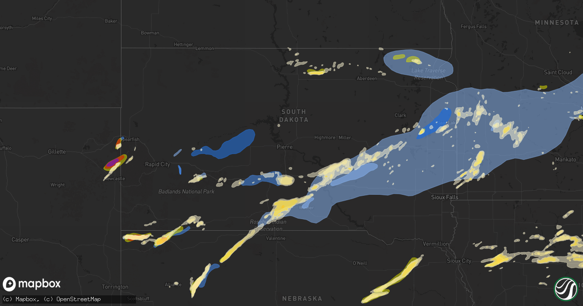
Hail Map in South Dakota on August 15, 2025
Get this storm
August 15 map
$229
one time, instant access
Download today. No call, no setup
Keep the $229
Bought the map and want the full workflow? Apply the entire $229 to a subscription within 7 days. None of it is wasted.
Every map, not just this one
This buys you this map. Subscription and you get every map we run, in the markets you choose from a few cities to whole states to nationwide. Plus real-time alerts the moment a storm fires.
Contact data
Name, contact info, occupancy, even credit band for addresses in the footprint. You go from where it hit to who to call.
Become the source they trust
Unlimited branding weather history reports on demand. You already have the documented answer ready for the property owner, and you are the one who showed up with it.
Property data and RoofTrace estimates
Pull up any address you have got, its value and the exact code rules for that jurisdiction, straight from One Click Code. Then RoofTrace estimates the squares, pitch, and roof value, priced the way you price.
Storm reports in South Dakota
South Dakota
| Date | Description |
|---|---|
| 08/15/20254:32 AM CDT | Mesonet station 291 4n altamont |
| 08/15/20254:22 AM CDT | Mesonet station 224 sd rwis ward. |
| 08/15/20254:19 AM CDT | Several trees down in clear lake. Time estimated based on radar. |
| 08/15/20254:18 AM CDT | Mesonet station 47 brandt |
| 08/15/20254:18 AM CDT | Asos station katy watertown muni ap. |
| 08/15/20254:18 AM CDT | Semi-truck pushed over at mile marker 156. Time estimated based on radar and wind 1 mile north of site. |
| 08/15/20254:18 AM CDT | Semi-truck pushed over at mile marker 157. Time estimated based on radar and wind observation at site. |
| 08/15/20254:15 AM CDT | Estimated wind gusts in excess of 60 mph. Items blown off of a deck. Time estimated from radar. |
| 08/15/20254:08 AM CDT | Mesonet station 318 4 wsw stone bridge |
| 08/15/20253:59 AM CDT | Corrects time of previous tstm wnd dmg report from volga - time estimated by radar. Social media report: received a picture of estimated 4-5 inch diameter branches down |
| 08/15/20253:59 AM CDT | Em reports a couple of light poles knocked down near us hwy 14. Time estimated by radar. |
| 08/15/20253:57 AM CDT | Mesonet station 162 sd rwis arlington. |
| 08/15/20253:53 AM CDT | Mesonet station 262 4w bryant |
| 08/15/20253:43 AM CDT | Tree broken about halfway up... Fell into power lines and north onto road across 200th st. Just west of 441st ave. Time estimated from radar. |
| 08/15/20253:35 AM CDT | Sheriff office reports extensive tree damage in de smet city limits. No reports of structural damage at this time. Time estimated from radar. |
| 08/15/20253:34 AM CDT | Mesonet station 297 sd rwis howard. |
| 08/15/20253:15 AM CDT | Recorded at khon asos. |
| 08/15/20253:10 AM CDT | Social media report with pictures of large tree branches down. Estimated size 6-8 inches. Tree appeared healthy. Time estimated by radar. |
| 08/15/20253:08 AM CDT | Asos station kmhe mitchell municipal airport. |
| 08/15/20253:06 AM CDT | Mesonet station 305 sd rwis lane. |
| 08/15/20253:00 AM CDT | Mesonet station lcms2 letcher 2ene |
| 08/15/20252:51 AM CDT | Mesonet station 305 sd rwis lane. |
| 08/15/20252:47 AM CDT | Mesonet station 201 gann valley |
| 08/15/20252:43 AM CDT | Via personal weather station. |
| 08/15/20252:40 AM CDT | Multiple trees down... Time estimated from radar. |
| 08/15/20252:39 AM CDT | Mesonet station 214 sd rwis plankinton. |
| 08/15/20252:33 AM CDT | Via personal weather station. |
| 08/15/20252:30 AM CDT | Social media report with picture of full sized tree broken in half. Size estimate 16+ inches. Tree appeared to be in good health. Also reported minor damage to building |
| 08/15/20252:30 AM CDT | Mesonet station wtes2 white lake |
| 08/15/20252:30 AM CDT | Via personal weather station. |
| 08/15/20252:19 AM CDT | Mesonet station 25 sd rwis kimball. |
| 08/15/20252:19 AM CDT | Social media report with picture of large branches down. Estimated size 8 to 10 inches. Tree appeared to be healthy. Time estimated by radar. |
| 08/15/20252:18 AM CDT | Via personal weather station. |
| 08/15/20252:15 AM CDT | Asos station k9v9 chamberlain municipal airport. |
| 08/15/20252:12 AM CDT | Via personal weather station. |
| 08/15/20252:02 AM CDT | Recorded via personal weather station in chamberlain. |
| 08/15/20252:00 AM CDT | Mesonet station ocms2 oacoma 2w |
| 08/15/20251:56 AM CDT | A local report indicates 66 MPH wind near 6 SSW Oacoma |
| 08/15/20251:55 AM CDT | Mesonet station grms2 gregory 16n |
| 08/15/20251:55 AM CDT | Mesonet station 54 reliance |
| 08/15/20251:52 AM CDT | Mesonet station 283 sd rwis dixon. |
| 08/15/20251:50 AM CDT | Sdsu mesonet |
| 08/15/20251:50 AM CDT | Sdsu mesonet. |
| 08/15/20251:29 AM CDT | A local report indicates 79 MPH wind near 1 NE Winner |
| 08/15/20251:14 AM CDT | A local report indicates 58 MPH wind near 4 SSE Witten |
| 08/15/202512:55 AM CDT | Sdsu mesonet. |
| 08/15/202512:55 AM CDT | Sdsu mesonet |
| 08/15/202512:50 AM CDT | Sdsu mesonet. |
| 08/15/202512:50 AM CDT | Sdsu mesonet |
| 08/14/202511:17 PM CDT | A local report indicates 58 MPH wind near 10 NNW Ottumwa |
| 08/14/202510:39 PM CDT | A local report indicates 70 MPH wind near 16 SW Milesville |
| 08/14/20259:35 PM CDT | A local report indicates 62 MPH wind near 8 S Wall |
| 08/14/20259:03 PM CDT | A local report indicates 60 MPH wind near 3 ESE Pine Ridge |
| 08/14/20259:00 PM CDT | Sdsu mesonet. |
| 08/14/20259:00 PM CDT | Sdsu mesonet |
| 08/14/20258:20 PM CDT | A local report indicates 60 MPH wind near 13 W Oglala |
| 08/14/20258:15 PM CDT | A local report indicates 60 MPH wind near 7 W Dwtn Spearfish |
All States Impacted by Hail Map on August 15, 2025
Cities Impacted by Hail Map on August 15, 2025
- Lake City, SD
- Ericson, NE
- Sisseton, SD
- Ypsilanti, ND
- Bartlett, NE
- Veblen, SD
- Britton, SD
- Amherst, SD
- Hecla, SD
- Claremont, SD
- Langford, SD
- Roslyn, SD
- Eden, SD
- Pierpont, SD
- Houghton, SD
- Claire City, SD
- New Effington, SD
- Summit, SD
- Peever, SD
- Grenville, SD
- Browns Valley, MN
- Rosholt, SD
- Beardsley, MN
- Wilmot, SD
- Elgin, NE
- Marion, ND
- Ewing, NE
- Spalding, NE
- Petersburg, NE
- Clearwater, NE
- Valley City, ND
- Oakdale, NE
- Neligh, NE
- Plainview, NE
- Meadow Grove, NE
- Tilden, NE
- Oriska, ND
- Buffalo, ND
- Graceville, MN
- Wheaton, MN
- Dumont, MN
- Barry, MN
- Creighton, NE
- Estelline, SD
- Kranzburg, SD
- Milbank, SD
- Albion, NE
- Goodwin, SD
- Utica, SD
- Menno, SD
- Stockholm, SD
- Strandburg, SD
- Marion, SD
- Tabor, SD
- Winfred, SD
- Ramona, SD
- Crofton, NE
- Salem, SD
- Corona, SD
- Madison, SD
- Montrose, SD
- South Shore, SD
- Twin Brooks, SD
- Bloomfield, NE
- Watertown, SD
- Wausa, NE
- Castlewood, SD
- Bridgewater, SD
- Bruce, SD
- Oldham, SD
- Arlington, SD
- Clinton, MN
- Canistota, SD
- Freeman, SD
- Lesterville, SD
- Ortonville, MN
- Yankton, SD
- Osmond, NE
- Pierce, NE
- Tower City, ND
- Arthur, ND
- Hunter, ND
- Mclean, NE
- Randolph, NE
- Magnet, NE
- Gardner, ND
- Harwood, ND
- Argusville, ND
- Hartington, NE
- Coleridge, NE
- Glidden, IA
- Churdan, IA
- Scranton, IA
- Remsen, IA
- Le Mars, IA
- Kingsley, IA
- Farnhamville, IA
- Gowrie, IA
- Jefferson, IA
- Marcus, IA
- Correctionville, IA
- Pierson, IA
- Cherokee, IA
- Cleghorn, IA
- Holstein, IA
- Cushing, IA
- Washta, IA
- Aurelia, IA
- Galva, IA
- Crossville, TN
- Grandview, TN
- Alta, IA
- Gonzales, LA
- Saint Amant, LA
- Schaller, IA
- Webb, IA
- Rembrandt, IA
- Sioux Rapids, IA
- Marathon, IA
- Albert City, IA
- Laurens, IA
- Storm Lake, IA
- Fonda, IA
- Emmetsburg, IA
- Mallard, IA
- Bode, IA
- Humboldt, IA
- Livermore, IA
- Havelock, IA
- Danbury, IA
- Rolfe, IA
- Curlew, IA
- Anthon, IA
- Equality, AL
- Alexander City, AL
- Battle Creek, IA
- Vincent, AL
- Clare, IA
- Palmer, IA
- Manson, IA
- Bradgate, IA
- Gilmore City, IA
- Pomeroy, IA
- Pocahontas, IA
- Lu Verne, IA
- Ottosen, IA
- Plover, IA
- Rutland, IA
- Algona, IA
- Wesley, IA
- Renwick, IA
- Hardy, IA
- Sterrett, AL
- Dothan, AL
- Ida Grove, IA
- Titonka, IA
- Duncombe, IA
- Newell, IA
- Corwith, IA
- Goldfield, IA
- Eagle Grove, IA
- Clarion, IA
- Woden, IA
- Kanawha, IA
- Eclectic, AL
- Trussville, AL
- Pell City, AL
- Buffalo Center, IA
- Woolstock, IA
- Forest City, IA
- Belmond, IA
- Webster City, IA
- Vincent, IA
- Vandiver, AL
- Early, IA
- Raleigh, MS
- Thompson, IA
- Harpersville, AL
- Rowan, IA
- Goodell, IA
- Morse, LA
- Meservey, IA
- Jamestown, TN
- Jolley, IA
- Oxford, AL
- Forest, MS
- Williams, IA
- Rockwell City, IA
- Barnum, IA
- Sheffield, IA
- Dows, IA
- Alexander, IA
- Latimer, IA
- Hampton, IA
- Anniston, AL
- Munford, AL
- Egan, LA
- Alexandria, AL
- Jacksonville, AL
- Weaver, AL
- Galt, IA
- Coulter, IA
- Kokomo, MS
- Plaucheville, LA
- Rockwell, IA
- Signal Mountain, TN
- Fort Dodge, IA
- Alden, IA
- Ragley, LA
- Chapin, IA
- Somers, IA
- Waynesboro, TN
- Marble Rock, IA
- Dumont, IA
- Tylertown, MS
- Bristow, IA
- Aredale, IA
- Rockford, IA
- Dougherty, IA
- Moorland, IA
- Greene, IA
- Geneva, IA
- Iowa Falls, IA
- Badger, IA
- Clarksville, IA
- Blairsburg, IA
- Reeves, LA
- Clifton, TN
- Bradford, IA
- Allison, IA
- Plainfield, IA
- Crossville, AL
- Albertville, AL
- Popejoy, IA
- Jemison, AL
- Waverly, IA
- Minneapolis, MN
- Nashua, IA
- Kamrar, IA
- Parkersburg, IA
- Aplington, IA
- Orlando, FL
- Boaz, AL
- Clanton, AL
- North Port, FL
- Saint Paul, MN
- Forest Hill, LA
- Jewell, IA
- Stanhope, IA
- Wellsburg, IA
- Steamboat Rock, IA
- Ackley, IA
- Ellsworth, IA
- Hopkins, MN
- Shell Rock, IA
- Radcliffe, IA
- Monteagle, TN
- Cedar Falls, IA
- Dike, IA
- Holland, IA
- Grundy Center, IA
- Hubbard, IA
- Glenmora, LA
- Conrad, IA
- Reinbeck, IA
- Atlanta, GA
- Ash Fork, AZ
- Sewanee, TN
- Pulaski, TN
- Akron, CO
- Beaman, IA
- Gladbrook, IA
- McCallsburg, IA
- Sherwood, TN
- Waterloo, IA
- Eldora, IA
- Hudson, IA
- Traer, IA
- Pitkin, LA
- Pineville, LA
- Santa Fe, NM
- Saint Cloud, FL
- Myakka City, FL
- Deville, LA
- Victoria, MN
- Waconia, MN
- Chaska, MN
- Excelsior, MN
- Buckingham, IA
- Dysart, IA
- Zearing, IA
- Inver Grove Heights, MN
- South Saint Paul, MN
- Maplesville, AL
- Randolph, AL
- Union, IA
- Lawley, AL
- Thorsby, AL
- New Edinburg, AR
- New Providence, IA
- Newport, MN
- Sarasota, FL
- La Porte City, IA
- Evansdale, IA
- Raymond, IA
- Cottage Grove, MN
- Mendota, MN
- Saint Paul Park, MN
- Whitten, IA
- Liscomb, IA
- Clemons, IA
- Hastings, MN
- Chanhassen, MN
- Ball, LA
- Marenisco, MI
- Lanse, MI
- Marshalltown, IA
- Rison, AR
- Durand, WI
- Arkansaw, WI
- Colfax, LA
- Chipley, FL
- Albion, IA
- Lincoln, IA
- Garwin, IA
- Toledo, IA
- River Falls, WI
- Prescott, WI
- Rogers, MN
- Maple Grove, MN
- Dayton, MN
- Osseo, MN
- Champlin, MN
- Anoka, MN
- Montour, IA
- Bay City, WI
- Independence, IA
- Marion, AL
- Ellsworth, WI
- Farmington, MN
- Winthrop, IA
- Masonville, IA
- Plum City, WI
- Elmwood, WI
- Garrison, IA
- Eau Galle, WI
- Mount Auburn, IA
- Vinton, IA
- Beldenville, WI
- Afton, MN
- Dry Prong, LA
- Rosemount, MN
- Clutier, IA
- Urbana, IA
- Center Point, IA
- Elberon, IA
- Nelson, WI
- Alma, WI
- Walker, IA
- Rowley, IA
- Eden Valley, MN
- Carthage, AR
- Keystone, IA
- Van Horne, IA
- Gravel Switch, KY
- Belle Plaine, IA
- Aurora, IA
- Maiden Rock, WI
- Prospect, TN
- Sparkman, AR
- Burns, WY
- Elkmont, AL
- Tama, IA
- Vermillion, MN
- Hampton, MN
- Vining, IA
- Chelsea, IA
- Palo, IA
- Central City, IA
- Shellsburg, IA
- Toddville, IA
- Newhall, IA
- Alburnett, IA
- Marion, IA
- Quasqueton, IA
- Coggon, IA
- Brandon, IA
- Jesup, IA
- Gilbertville, IA
- Ryan, IA
- Monticello, IA
- Prairieburg, IA
- Anamosa, IA
- Watkins, MN
- Walford, IA
- Hiawatha, IA
- Robins, IA
- Norway, IA
- Cedar Rapids, IA
- Blairstown, IA
- Watkins, IA
- Atkins, IA
- Fairfax, IA
- Luzerne, IA
- Amana, IA
- Swisher, IA
- Ely, IA
- Mount Vernon, IA
- Martelle, IA
- Springville, IA
- Minnetonka, MN
- Eden Prairie, MN
- Albin, WY
- Manchester, IA
- Lester, AL
- Hager City, WI
- Lake Elmo, MN
- Harrison, NE
- Florence, AL
- Ladora, IA
- Shuqualak, MS
- Hustonville, KY
- Welch, MN
- Lisbon, IA
- North Liberty, IA
- Oxford, IA
- Coralville, IA
- Solon, IA
- Iowa City, IA
- Tiffin, IA
- Langworthy, IA
- Mondovi, WI
- Circle Pines, MN
- Hugo, MN
- Red Wing, MN
- Olin, IA
- Mechanicsville, IA
- Morley, IA
- Center Junction, IA
- Burnsville, MN
- Lakeville, MN
- Marengo, IA
- Guyton, GA
- Watertown, MN
- South Amana, IA
- Newcastle, WY
- Mayer, MN
- Sheridan, AR
- Leola, AR
- Savage, MN
- Hopkinton, IA
- Wayzata, MN
- Maple Plain, MN
- Spring Park, MN
- Mound, MN
- Saint Bonifacius, MN
- Prior Lake, MN
- Shakopee, MN
- Wiggins, CO
- Williamsburg, IA
- Anacoco, LA
- Cologne, MN
- Tipton, IA
- Wyoming, IA
- Onslow, IA
- West Branch, IA
- Clarence, IA
- Stanwood, IA
- Oxford Junction, IA
- Osage, WY
- Lakeland, MN
- Preston, MS
- Natchitoches, LA
- Stillwater, MN
- Jefferson, AR
- Redfield, AR
- Jasper, AL
- Crane Hill, AL
- Muscle Shoals, AL
- Fort Morgan, CO
- West Liberty, IA
- Lowden, IA
- Wheatland, IA
- Bennett, IA
- Atalissa, IA
- Lost Nation, IA
- Hill City, SD
- Lead, SD
- Prescott Valley, AZ
- Andover, MN
- Gila Bend, AZ
- Weldona, CO
- Green Valley, AZ
- Uniontown, AL
- Newbern, AL
- Powder Springs, GA
- Austell, GA
- Marietta, GA
- Stockholm, WI
- Pepin, WI
- Reads Landing, MN
- Wabasha, MN
- Cochrane, WI
- Altura, MN
- Arcadia, WI
- Fountain City, WI
- Durant, IA
- Dixon, IA
- Calamus, IA
- New Liberty, IA
- Walcott, IA
- Moscow, IA
- Wilton, IA
- Stockton, IA
- Independence, WI
- Delhi, LA
- Winnsboro, LA
- Corinth, MS
- De Kalb, MS
- Parker Dam, CA
- Parker, AZ
- Bentonia, MS
- Davenport, IA
- Donahue, IA
- Eldridge, IA
- Grand Mound, IA
- Long Grove, IA
- Dodge, WI
- Crawford, NE
- Whitney, NE
- Swainsboro, GA
- Whitehall, WI
- Benton, MS
- Tignall, GA
- Arkadelphia, AR
- Glen, MS
- Galesville, WI
- Trempealeau, WI
- Winona, MN
- Dakota, MN
- Holmen, WI
- Onalaska, WI
- Donaldson, AR
- Strum, WI
- Russellville, AL
- Pelican, LA
- Rayville, LA
- Malvern, AR
- La Crosse, WI
- Canton, MS
- Mansfield, LA
- Spring Valley, WI
- Phil Campbell, AL
- Washington, GA
- New Raymer, CO
- Vaughan, MS
- Middle Amana, IA
- Oelrichs, SD
- Umpire, AR
- Black River Falls, WI
- Lincolnton, GA
- Sundance, WY
- Beulah, WY
- Spearfish, SD
- Edgemont, SD
- Stoneham, CO
- Forest Lake, MN
- Okolona, AR
- Camden, MS
- Delhi, IA
- Cascade, IA
- Rio Rico, AZ
- Sells, AZ
- Lone Tree, IA
- Deadwood, SD
- Chadron, NE
- Thorp, WI
- Stanley, WI
- Tomah, WI
- Warrens, WI
- Sparta, WI
- Nogales, AZ
- Bouse, AZ
- Padroni, CO
- Kimball, NE
- Grove Hill, AL
- Dover, MN
- Plainview, MN
- Saint Charles, MN
- Camp Douglas, WI
- Necedah, WI
- Dix, NE
- New Underwood, SD
- Thomasville, AL
- Jackson, AL
- Pine Ridge, SD
- Hay Springs, NE
- Rushville, NE
- Scenic, SD
- Wall, SD
- Kellogg, MN
- Potter, NE
- Manderson, SD
- Wounded Knee, SD
- Dalton, NE
- Wasta, SD
- Porcupine, SD
- Sargeant, MN
- Eyota, MN
- Kirkland, AZ
- Philip, SD
- Milesville, SD
- Stewartville, MN
- Markesan, WI
- Alliance, NE
- Spring Valley, MN
- Merriman, NE
- Lakeside, NE
- Ellsworth, NE
- Grand Meadow, MN
- Ostrander, MN
- Midland, SD
- Bingham, NE
- Interior, SD
- Kadoka, SD
- Wanblee, SD
- Long Valley, SD
- Cody, NE
- Belvidere, SD
- Ashby, NE
- White River, SD
- Okaton, SD
- Congress, AZ
- Le Roy, MN
- Chester, IA
- Hayes, SD
- Fort Pierre, SD
- Cresco, IA
- Lime Springs, IA
- Murdo, SD
- Ridgeway, IA
- Nenzel, NE
- Kilgore, NE
- Mcgregor, MN
- Palisade, MN
- Wright, MN
- Tamarack, MN
- Floodwood, MN
- Draper, SD
- Wood, SD
- Batesland, SD
- Mission, SD
- Saint Francis, SD
- Reynolds, IL
- Muscatine, IA
- Milan, IL
- Buffalo, IA
- Andalusia, IL
- Blue Grass, IA
- Taylor Ridge, IL
- Viola, IL
- Matherville, IL
- Aledo, IL
- Rock Island, IL
- Sherrard, IL
- Rio, IL
- Coal Valley, IL
- Alpha, IL
- New Windsor, IL
- Orion, IL
- Alexis, IL
- Moline, IL
- Bettendorf, IA
- North Henderson, IL
- Galesburg, IL
- Dahinda, IL
- Woodhull, IL
- East Galesburg, IL
- Wataga, IL
- Elmwood, IL
- Cambridge, IL
- Yates City, IL
- Oneida, IL
- Maquon, IL
- Gilson, IL
- Knoxville, IL
- Lynn Center, IL
- Trivoli, IL
- Ophiem, IL
- Osco, IL
- East Moline, IL
- Silvis, IL
- Victoria, IL
- Andover, IL
- Altona, IL
- Henderson, IL
- Williamsfield, IL
- Pleasant Valley, IA
- Le Claire, IA
- Galva, IL
- Port Byron, IL
- Hampton, IL
- Hillsdale, IL
- Carbon Cliff, IL
- Colona, IL
- Geneseo, IL
- Vivian, SD
- Calmar, IA
- Decorah, IA
- Winner, SD
- Okreek, SD
- Bradford, IL
- Atkinson, IL
- Princeville, IL
- La Fayette, IL
- Laura, IL
- Toulon, IL
- Buda, IL
- Bishop Hill, IL
- Wyoming, IL
- Neponset, IL
- Kewanee, IL
- Speer, IL
- Brimfield, IL
- Sheffield, IL
- Annawan, IL
- Sparland, IL
- Dunlap, IL
- Edelstein, IL
- Tiskilwa, IL
- Hanna City, IL
- Edwards, IL
- Chillicothe, IL
- Henry, IL
- Rosebud, SD
- Fort Atkinson, IA
- Spillville, IA
- Ossian, IA
- Presho, SD
- Pierre, SD
- Witten, SD
- Dunkerton, IA
- Ideal, SD
- Castalia, IA
- Colome, SD
- Hamill, SD
- Mound City, SD
- Kennebec, SD
- Fairbury, IL
- Dallas, SD
- Gregory, SD
- Oacoma, SD
- Chamberlain, SD
- Reliance, SD
- Forrest, IL
- Chatsworth, IL
- Pukwana, SD
- Burke, SD
- Platte, SD
- Herreid, SD
- Gann Valley, SD
- Kimball, SD
- Lower Brule, SD
- Fort Thompson, SD
- Alpena, SD
- Java, SD
- Pollock, SD
- Wessington Springs, SD
- Garretson, SD
- Jasper, MN
- Pipestone, MN
- Carver, MN
- Wyoming, MN
- Cavour, SD
- Artesian, SD
- Woonsocket, SD
- Bowdle, SD
- Eureka, SD
- Hayfield, MN
- Dexter, MN
- Trent, SD
- Huron, SD
- White Lake, SD
- Plankinton, SD
- Stickney, SD
- Hosmer, SD
- Virgil, SD
- Rankin, IL
- Edgerton, MN
- Wessington, SD
- Mitchell, SD
- Mount Vernon, SD
- Letcher, SD
- Lake Norden, SD
- Bryant, SD
- Iroquois, SD
- Cissna Park, IL
- Flandreau, SD
- Wolsey, SD
- Fulton, SD
- Alexandria, SD
- Hardwick, MN
- Wellington, IL
- Hoopeston, IL
- De Smet, SD
- Woodstock, MN
- Carthage, SD
- Howard, SD
- Fedora, SD
- Canova, SD
- Ethan, SD
- Spencer, SD
- Emery, SD
- Hayti, SD
- Toronto, SD
- Brandt, SD
- Hague, ND
- Roscoe, SD
- Linton, ND
- Luverne, MN
- Lake Wilson, MN
- Leola, SD
- Rossville, IL
- Colton, SD
- Humboldt, SD
- Lake Preston, SD
- Willow Lake, SD
- Clear Lake, SD
- Chandler, MN
- Astoria, SD
- Nunda, SD
- Rutland, SD
- Wentworth, SD
- McMillan, MI
- Madison, MN
- Canby, MN
- Marietta, MN
- Vienna, SD
- Hazel, SD
- Dawson, MN
- Boyd, MN
- Hanley Falls, MN
- Wood Lake, MN
- Granite Falls, MN
- Gary, SD
- Ruthton, MN
- Holland, MN
- Minneota, MN
- Montevideo, MN
- Vesta, MN
- Cottonwood, MN
- Balaton, MN
- Revillo, SD
- Belview, MN
- Echo, MN
- Bellingham, MN
- Clarkfield, MN
- Sacred Heart, MN
- Taunton, MN
- Appleton, MN
- Watson, MN
- Milan, MN
- Carpenter, SD
- Yale, SD
- Erwin, SD
- Brookings, SD
- Sinai, SD
- Baltic, SD
- Badger, SD
- Egan, SD
- Dell Rapids, SD
- Colman, SD
- Volga, SD
- Hartford, SD
- Chester, SD
- Elkton, SD
- Aurora, SD
- Lake Benton, MN
- White, SD
- Labolt, SD
- Arco, MN
- Lucan, MN
- Seaforth, MN
- Garvin, MN
- Lynd, MN
- Russell, MN
- Redwood Falls, MN
- Tracy, MN
- Walnut Grove, MN
- Wabasso, MN
- Hendricks, MN
- Marshall, MN
- Tyler, MN
- Ghent, MN
- Porter, MN
- Milroy, MN
- Ivanhoe, MN
- Correll, MN
- Maynard, MN
- Danube, MN
- Morton, MN
- Renville, MN
- Clements, MN
- Morgan, MN
- Sleepy Eye, MN
- Holloway, MN
- Danvers, MN
- Franklin, MN
- Big Stone City, SD
- Odessa, MN
- Westport, SD
- Benson, MN
- Avoca, MN
- Dovray, MN
- Olivia, MN
- Iona, MN
- Westbrook, MN
- Lamberton, MN
- Sanborn, MN
- Springfield, MN
- Currie, MN
- Slayton, MN
- Revere, MN
- Clara City, MN
- Wanda, MN
- Fairfax, MN
- New Ulm, MN
- Hector, MN
- Lafayette, MN
- Bird Island, MN
- Gibbon, MN
- Blomkest, MN
- Murdock, MN
- Prinsburg, MN
- Raymond, MN
- Mason City, IA
- Rochester, MN
- Elgin, MN
- Waveland, IN
- Marshall, IN
- Harmony, MN
- Preston, MN
- Racine, MN
- Dewar, IA
- Melrose, WI
- Utica, MN
- Lake Lillian, MN
- Willmar, MN
- Kerkhoven, MN
- Glenwood, MN
- Sunburg, MN
- Starbuck, MN
- Pennock, MN
- New London, MN
- Spicer, MN
- Kandiyohi, MN
- Brooten, MN
- Atwater, MN
- Columbia, SD
- Groton, SD
- Rockville, IN
- Lismore, MN
- Litchfield, MN
- Hutchinson, MN
- Cosmos, MN
- Buffalo Lake, MN
- Grove City, MN
- Goetzville, MI
- Oakes, ND
- Comfrey, MN
- Stewart, MN
- Darwin, MN
- Paynesville, MN
- Glencoe, MN
- New Auburn, MN
- Le Sueur, MN
- Arlington, MN
- Gaylord, MN
- Courtland, MN
- Winthrop, MN
- Henderson, MN
- Nicollet, MN
- Brownton, MN
- Saint Peter, MN
- South Haven, MN
- Dassel, MN
- De Tour Village, MI
- Silver Lake, MN
- Winsted, MN
- Plato, MN
- Howard Lake, MN
- Lester Prairie, MN
- Green Isle, MN
- Hamburg, MN
- Cokato, MN
- Maple Lake, MN
- Norwood Young America, MN
- Young America, MN
- Becker, MN
- Clear Lake, MN
- Albertville, MN
- New Germany, MN
- Clearwater, MN
- Saint Michael, MN
- Annandale, MN
- Monticello, MN
- Buffalo, MN
- Hanover, MN
- Big Lake, MN
- Kimball, MN
- Belle Plaine, MN
- Elk River, MN
- Montrose, MN
- Rockford, MN
- Waverly, MN
- Zimmerman, MN
- Princeton, MN
- Delano, MN
- Cedar, MN
- Isanti, MN
- Loretto, MN
- Hamel, MN
- Bethel, MN
- Saint Francis, MN
- Cambridge, MN
- Long Lake, MN
- Pierz, MN
- Garden City, MN
- Lake Crystal, MN
- Vernon Center, MN
- Madelia, MN


