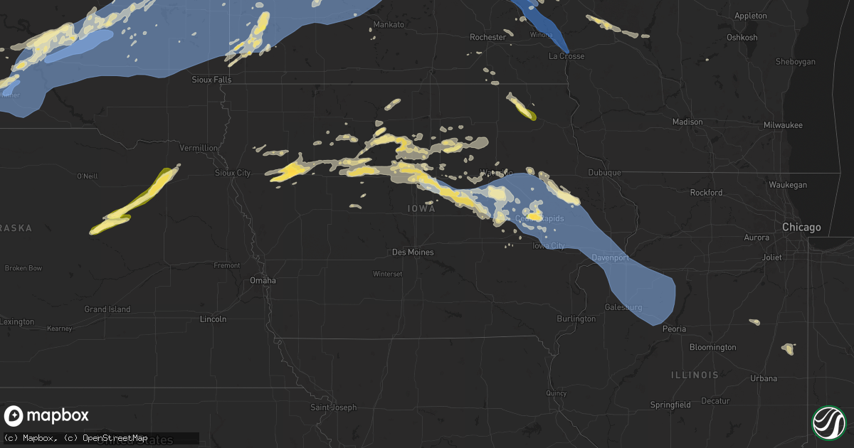
Hail Map in Iowa on August 15, 2025
Get this storm
August 15 map
$229
one time, instant access
Download today. No call, no setup
Keep the $229
Bought the map and want the full workflow? Apply the entire $229 to a subscription within 7 days. None of it is wasted.
Every map, not just this one
This buys you this map. Subscription and you get every map we run, in the markets you choose from a few cities to whole states to nationwide. Plus real-time alerts the moment a storm fires.
Contact data
Name, contact info, occupancy, even credit band for addresses in the footprint. You go from where it hit to who to call.
Become the source they trust
Unlimited branding weather history reports on demand. You already have the documented answer ready for the property owner, and you are the one who showed up with it.
Property data and RoofTrace estimates
Pull up any address you have got, its value and the exact code rules for that jurisdiction, straight from One Click Code. Then RoofTrace estimates the squares, pitch, and roof value, priced the way you price.
Storm reports in Iowa
Iowa
| Date | Description |
|---|---|
| 08/15/20256:30 PM CDT | Many tree branches ranging in sizes up to 6 inches in diameter down here. |
| 08/15/20256:28 PM CDT | Downed tree approx 1.5 ft diameter on melrose ave @ mormon trek... Iowa city. |
| 08/15/20256:28 PM CDT | Downed tree approx 1.5 ft diameter on melrose a |
| 08/15/20256:17 PM CDT | A local report indicates 60 MPH wind near Lowden |
| 08/15/20256:06 PM CDT | Downed tree approx. 2-2.5 ft diameter across. |
| 08/15/20256:01 PM CDT | Large tree limbs down along nearby roadways. |
| 08/15/20255:59 PM CDT | A local report indicates 69 MPH wind near Iowa City Municipality |
| 08/15/20255:54 PM CDT | Pws. |
| 08/15/20255:44 PM CDT | Several large branches down. Dime size hail too. |
| 08/15/20255:41 PM CDT | A local report indicates 60 MPH wind near 4 N Fairfax |
| 08/15/20255:40 PM CDT | A local report indicates 1.50 inch wind near 3 W Cedar Rapids |
| 08/15/20255:37 PM CDT | A local report indicates 71 MPH wind near Eastern Iowa Airport |
| 08/15/20255:36 PM CDT | Pws. |
| 08/15/20255:30 PM CDT | Pws. |
| 08/15/20255:22 PM CDT | Pws. |
| 08/15/20255:21 PM CDT | Pws. |
| 08/15/20255:17 PM CDT | Pws. |
| 08/15/20255:16 PM CDT | Pws. |
| 08/15/20255:15 PM CDT | Pws. |
| 08/15/20255:10 PM CDT | Report of 60+ mph winds. Time estimated by radar. |
| 08/15/20254:59 PM CDT | Measured by a personal weather station. Reports of trees down in town as well. |
| 08/15/20254:18 PM CDT | Numerous large tree branches down 3 inches in diameter or more. Delayed reported received via social media. |
| 08/15/20254:00 PM CDT | Trees down at campground. One camper was blown off of its blocks. Large tree limb fell on a truck. Large metal shed with door damage. Time estimated from radar. |
| 08/15/20253:45 PM CDT | 6-8 inch branches down. Bean crops flattened. Pea sized hail. Time estimated. |
| 08/15/20253:12 PM CDT | Corrects previous tstm wnd dmg report from shell rock. Several large tree limbs down in town. Delayed report. Corrected for date. |
| 08/15/20253:05 PM CDT | Report of a tree down in town. |
| 08/15/20252:45 PM CDT | A local report indicates 1.00 inch wind near Dumont |
| 08/15/20252:40 PM CDT | Tree down on a power line. Time estimated. |
| 08/15/20252:40 PM CDT | Trees down. Time estimated. |
| 08/15/20252:30 PM CDT | Trees and power lines down. Time estimated. |
| 08/15/20252:05 PM CDT | Report of trees down in belmond. Time estimated from radar. |
| 08/15/20251:20 PM CDT | Public report of quarter sized hail ongoing in holstein at at 1320 on 15 aug 2025. Corroborated time and likelihood of hail with radar. |
| 08/15/20251:01 PM CDT | Delayed report received via social media. Time estimated from radar. |
| 08/15/202512:12 PM CDT | Hail not quite as large as golf balls. Time estimated from radar. |
| 08/15/20251:13 AM CDT | A local report indicates 1.00 inch wind near Calmar |
All States Impacted by Hail Map on August 15, 2025
Cities Impacted by Hail Map on August 15, 2025
- Lake City, SD
- Ericson, NE
- Sisseton, SD
- Ypsilanti, ND
- Bartlett, NE
- Veblen, SD
- Britton, SD
- Amherst, SD
- Hecla, SD
- Claremont, SD
- Langford, SD
- Roslyn, SD
- Eden, SD
- Pierpont, SD
- Houghton, SD
- Claire City, SD
- New Effington, SD
- Summit, SD
- Peever, SD
- Grenville, SD
- Browns Valley, MN
- Rosholt, SD
- Beardsley, MN
- Wilmot, SD
- Elgin, NE
- Marion, ND
- Ewing, NE
- Spalding, NE
- Petersburg, NE
- Clearwater, NE
- Valley City, ND
- Oakdale, NE
- Neligh, NE
- Plainview, NE
- Meadow Grove, NE
- Tilden, NE
- Oriska, ND
- Buffalo, ND
- Graceville, MN
- Wheaton, MN
- Dumont, MN
- Barry, MN
- Creighton, NE
- Estelline, SD
- Kranzburg, SD
- Milbank, SD
- Albion, NE
- Goodwin, SD
- Utica, SD
- Menno, SD
- Stockholm, SD
- Strandburg, SD
- Marion, SD
- Tabor, SD
- Winfred, SD
- Ramona, SD
- Crofton, NE
- Salem, SD
- Corona, SD
- Madison, SD
- Montrose, SD
- South Shore, SD
- Twin Brooks, SD
- Bloomfield, NE
- Watertown, SD
- Wausa, NE
- Castlewood, SD
- Bridgewater, SD
- Bruce, SD
- Oldham, SD
- Arlington, SD
- Clinton, MN
- Canistota, SD
- Freeman, SD
- Lesterville, SD
- Ortonville, MN
- Yankton, SD
- Osmond, NE
- Pierce, NE
- Tower City, ND
- Arthur, ND
- Hunter, ND
- Mclean, NE
- Randolph, NE
- Magnet, NE
- Gardner, ND
- Harwood, ND
- Argusville, ND
- Hartington, NE
- Coleridge, NE
- Glidden, IA
- Churdan, IA
- Scranton, IA
- Remsen, IA
- Le Mars, IA
- Kingsley, IA
- Farnhamville, IA
- Gowrie, IA
- Jefferson, IA
- Marcus, IA
- Correctionville, IA
- Pierson, IA
- Cherokee, IA
- Cleghorn, IA
- Holstein, IA
- Cushing, IA
- Washta, IA
- Aurelia, IA
- Galva, IA
- Crossville, TN
- Grandview, TN
- Alta, IA
- Gonzales, LA
- Saint Amant, LA
- Schaller, IA
- Webb, IA
- Rembrandt, IA
- Sioux Rapids, IA
- Marathon, IA
- Albert City, IA
- Laurens, IA
- Storm Lake, IA
- Fonda, IA
- Emmetsburg, IA
- Mallard, IA
- Bode, IA
- Humboldt, IA
- Livermore, IA
- Havelock, IA
- Danbury, IA
- Rolfe, IA
- Curlew, IA
- Anthon, IA
- Equality, AL
- Alexander City, AL
- Battle Creek, IA
- Vincent, AL
- Clare, IA
- Palmer, IA
- Manson, IA
- Bradgate, IA
- Gilmore City, IA
- Pomeroy, IA
- Pocahontas, IA
- Lu Verne, IA
- Ottosen, IA
- Plover, IA
- Rutland, IA
- Algona, IA
- Wesley, IA
- Renwick, IA
- Hardy, IA
- Sterrett, AL
- Dothan, AL
- Ida Grove, IA
- Titonka, IA
- Duncombe, IA
- Newell, IA
- Corwith, IA
- Goldfield, IA
- Eagle Grove, IA
- Clarion, IA
- Woden, IA
- Kanawha, IA
- Eclectic, AL
- Trussville, AL
- Pell City, AL
- Buffalo Center, IA
- Woolstock, IA
- Forest City, IA
- Belmond, IA
- Webster City, IA
- Vincent, IA
- Vandiver, AL
- Early, IA
- Raleigh, MS
- Thompson, IA
- Harpersville, AL
- Rowan, IA
- Goodell, IA
- Morse, LA
- Meservey, IA
- Jamestown, TN
- Jolley, IA
- Oxford, AL
- Forest, MS
- Williams, IA
- Rockwell City, IA
- Barnum, IA
- Sheffield, IA
- Dows, IA
- Alexander, IA
- Latimer, IA
- Hampton, IA
- Anniston, AL
- Munford, AL
- Egan, LA
- Alexandria, AL
- Jacksonville, AL
- Weaver, AL
- Galt, IA
- Coulter, IA
- Kokomo, MS
- Plaucheville, LA
- Rockwell, IA
- Signal Mountain, TN
- Fort Dodge, IA
- Alden, IA
- Ragley, LA
- Chapin, IA
- Somers, IA
- Waynesboro, TN
- Marble Rock, IA
- Dumont, IA
- Tylertown, MS
- Bristow, IA
- Aredale, IA
- Rockford, IA
- Dougherty, IA
- Moorland, IA
- Greene, IA
- Geneva, IA
- Iowa Falls, IA
- Badger, IA
- Clarksville, IA
- Blairsburg, IA
- Reeves, LA
- Clifton, TN
- Bradford, IA
- Allison, IA
- Plainfield, IA
- Crossville, AL
- Albertville, AL
- Popejoy, IA
- Jemison, AL
- Waverly, IA
- Minneapolis, MN
- Nashua, IA
- Kamrar, IA
- Parkersburg, IA
- Aplington, IA
- Orlando, FL
- Boaz, AL
- Clanton, AL
- North Port, FL
- Saint Paul, MN
- Forest Hill, LA
- Jewell, IA
- Stanhope, IA
- Wellsburg, IA
- Steamboat Rock, IA
- Ackley, IA
- Ellsworth, IA
- Hopkins, MN
- Shell Rock, IA
- Radcliffe, IA
- Monteagle, TN
- Cedar Falls, IA
- Dike, IA
- Holland, IA
- Grundy Center, IA
- Hubbard, IA
- Glenmora, LA
- Conrad, IA
- Reinbeck, IA
- Atlanta, GA
- Ash Fork, AZ
- Sewanee, TN
- Pulaski, TN
- Akron, CO
- Beaman, IA
- Gladbrook, IA
- McCallsburg, IA
- Sherwood, TN
- Waterloo, IA
- Eldora, IA
- Hudson, IA
- Traer, IA
- Pitkin, LA
- Pineville, LA
- Santa Fe, NM
- Saint Cloud, FL
- Myakka City, FL
- Deville, LA
- Victoria, MN
- Waconia, MN
- Chaska, MN
- Excelsior, MN
- Buckingham, IA
- Dysart, IA
- Zearing, IA
- Inver Grove Heights, MN
- South Saint Paul, MN
- Maplesville, AL
- Randolph, AL
- Union, IA
- Lawley, AL
- Thorsby, AL
- New Edinburg, AR
- New Providence, IA
- Newport, MN
- Sarasota, FL
- La Porte City, IA
- Evansdale, IA
- Raymond, IA
- Cottage Grove, MN
- Mendota, MN
- Saint Paul Park, MN
- Whitten, IA
- Liscomb, IA
- Clemons, IA
- Hastings, MN
- Chanhassen, MN
- Ball, LA
- Marenisco, MI
- Lanse, MI
- Marshalltown, IA
- Rison, AR
- Durand, WI
- Arkansaw, WI
- Colfax, LA
- Chipley, FL
- Albion, IA
- Lincoln, IA
- Garwin, IA
- Toledo, IA
- River Falls, WI
- Prescott, WI
- Rogers, MN
- Maple Grove, MN
- Dayton, MN
- Osseo, MN
- Champlin, MN
- Anoka, MN
- Montour, IA
- Bay City, WI
- Independence, IA
- Marion, AL
- Ellsworth, WI
- Farmington, MN
- Winthrop, IA
- Masonville, IA
- Plum City, WI
- Elmwood, WI
- Garrison, IA
- Eau Galle, WI
- Mount Auburn, IA
- Vinton, IA
- Beldenville, WI
- Afton, MN
- Dry Prong, LA
- Rosemount, MN
- Clutier, IA
- Urbana, IA
- Center Point, IA
- Elberon, IA
- Nelson, WI
- Alma, WI
- Walker, IA
- Rowley, IA
- Eden Valley, MN
- Carthage, AR
- Keystone, IA
- Van Horne, IA
- Gravel Switch, KY
- Belle Plaine, IA
- Aurora, IA
- Maiden Rock, WI
- Prospect, TN
- Sparkman, AR
- Burns, WY
- Elkmont, AL
- Tama, IA
- Vermillion, MN
- Hampton, MN
- Vining, IA
- Chelsea, IA
- Palo, IA
- Central City, IA
- Shellsburg, IA
- Toddville, IA
- Newhall, IA
- Alburnett, IA
- Marion, IA
- Quasqueton, IA
- Coggon, IA
- Brandon, IA
- Jesup, IA
- Gilbertville, IA
- Ryan, IA
- Monticello, IA
- Prairieburg, IA
- Anamosa, IA
- Watkins, MN
- Walford, IA
- Hiawatha, IA
- Robins, IA
- Norway, IA
- Cedar Rapids, IA
- Blairstown, IA
- Watkins, IA
- Atkins, IA
- Fairfax, IA
- Luzerne, IA
- Amana, IA
- Swisher, IA
- Ely, IA
- Mount Vernon, IA
- Martelle, IA
- Springville, IA
- Minnetonka, MN
- Eden Prairie, MN
- Albin, WY
- Manchester, IA
- Lester, AL
- Hager City, WI
- Lake Elmo, MN
- Harrison, NE
- Florence, AL
- Ladora, IA
- Shuqualak, MS
- Hustonville, KY
- Welch, MN
- Lisbon, IA
- North Liberty, IA
- Oxford, IA
- Coralville, IA
- Solon, IA
- Iowa City, IA
- Tiffin, IA
- Langworthy, IA
- Mondovi, WI
- Circle Pines, MN
- Hugo, MN
- Red Wing, MN
- Olin, IA
- Mechanicsville, IA
- Morley, IA
- Center Junction, IA
- Burnsville, MN
- Lakeville, MN
- Marengo, IA
- Guyton, GA
- Watertown, MN
- South Amana, IA
- Newcastle, WY
- Mayer, MN
- Sheridan, AR
- Leola, AR
- Savage, MN
- Hopkinton, IA
- Wayzata, MN
- Maple Plain, MN
- Spring Park, MN
- Mound, MN
- Saint Bonifacius, MN
- Prior Lake, MN
- Shakopee, MN
- Wiggins, CO
- Williamsburg, IA
- Anacoco, LA
- Cologne, MN
- Tipton, IA
- Wyoming, IA
- Onslow, IA
- West Branch, IA
- Clarence, IA
- Stanwood, IA
- Oxford Junction, IA
- Osage, WY
- Lakeland, MN
- Preston, MS
- Natchitoches, LA
- Stillwater, MN
- Jefferson, AR
- Redfield, AR
- Jasper, AL
- Crane Hill, AL
- Muscle Shoals, AL
- Fort Morgan, CO
- West Liberty, IA
- Lowden, IA
- Wheatland, IA
- Bennett, IA
- Atalissa, IA
- Lost Nation, IA
- Hill City, SD
- Lead, SD
- Prescott Valley, AZ
- Andover, MN
- Gila Bend, AZ
- Weldona, CO
- Green Valley, AZ
- Uniontown, AL
- Newbern, AL
- Powder Springs, GA
- Austell, GA
- Marietta, GA
- Stockholm, WI
- Pepin, WI
- Reads Landing, MN
- Wabasha, MN
- Cochrane, WI
- Altura, MN
- Arcadia, WI
- Fountain City, WI
- Durant, IA
- Dixon, IA
- Calamus, IA
- New Liberty, IA
- Walcott, IA
- Moscow, IA
- Wilton, IA
- Stockton, IA
- Independence, WI
- Delhi, LA
- Winnsboro, LA
- Corinth, MS
- De Kalb, MS
- Parker Dam, CA
- Parker, AZ
- Bentonia, MS
- Davenport, IA
- Donahue, IA
- Eldridge, IA
- Grand Mound, IA
- Long Grove, IA
- Dodge, WI
- Crawford, NE
- Whitney, NE
- Swainsboro, GA
- Whitehall, WI
- Benton, MS
- Tignall, GA
- Arkadelphia, AR
- Glen, MS
- Galesville, WI
- Trempealeau, WI
- Winona, MN
- Dakota, MN
- Holmen, WI
- Onalaska, WI
- Donaldson, AR
- Strum, WI
- Russellville, AL
- Pelican, LA
- Rayville, LA
- Malvern, AR
- La Crosse, WI
- Canton, MS
- Mansfield, LA
- Spring Valley, WI
- Phil Campbell, AL
- Washington, GA
- New Raymer, CO
- Vaughan, MS
- Middle Amana, IA
- Oelrichs, SD
- Umpire, AR
- Black River Falls, WI
- Lincolnton, GA
- Sundance, WY
- Beulah, WY
- Spearfish, SD
- Edgemont, SD
- Stoneham, CO
- Forest Lake, MN
- Okolona, AR
- Camden, MS
- Delhi, IA
- Cascade, IA
- Rio Rico, AZ
- Sells, AZ
- Lone Tree, IA
- Deadwood, SD
- Chadron, NE
- Thorp, WI
- Stanley, WI
- Tomah, WI
- Warrens, WI
- Sparta, WI
- Nogales, AZ
- Bouse, AZ
- Padroni, CO
- Kimball, NE
- Grove Hill, AL
- Dover, MN
- Plainview, MN
- Saint Charles, MN
- Camp Douglas, WI
- Necedah, WI
- Dix, NE
- New Underwood, SD
- Thomasville, AL
- Jackson, AL
- Pine Ridge, SD
- Hay Springs, NE
- Rushville, NE
- Scenic, SD
- Wall, SD
- Kellogg, MN
- Potter, NE
- Manderson, SD
- Wounded Knee, SD
- Dalton, NE
- Wasta, SD
- Porcupine, SD
- Sargeant, MN
- Eyota, MN
- Kirkland, AZ
- Philip, SD
- Milesville, SD
- Stewartville, MN
- Markesan, WI
- Alliance, NE
- Spring Valley, MN
- Merriman, NE
- Lakeside, NE
- Ellsworth, NE
- Grand Meadow, MN
- Ostrander, MN
- Midland, SD
- Bingham, NE
- Interior, SD
- Kadoka, SD
- Wanblee, SD
- Long Valley, SD
- Cody, NE
- Belvidere, SD
- Ashby, NE
- White River, SD
- Okaton, SD
- Congress, AZ
- Le Roy, MN
- Chester, IA
- Hayes, SD
- Fort Pierre, SD
- Cresco, IA
- Lime Springs, IA
- Murdo, SD
- Ridgeway, IA
- Nenzel, NE
- Kilgore, NE
- Mcgregor, MN
- Palisade, MN
- Wright, MN
- Tamarack, MN
- Floodwood, MN
- Draper, SD
- Wood, SD
- Batesland, SD
- Mission, SD
- Saint Francis, SD
- Reynolds, IL
- Muscatine, IA
- Milan, IL
- Buffalo, IA
- Andalusia, IL
- Blue Grass, IA
- Taylor Ridge, IL
- Viola, IL
- Matherville, IL
- Aledo, IL
- Rock Island, IL
- Sherrard, IL
- Rio, IL
- Coal Valley, IL
- Alpha, IL
- New Windsor, IL
- Orion, IL
- Alexis, IL
- Moline, IL
- Bettendorf, IA
- North Henderson, IL
- Galesburg, IL
- Dahinda, IL
- Woodhull, IL
- East Galesburg, IL
- Wataga, IL
- Elmwood, IL
- Cambridge, IL
- Yates City, IL
- Oneida, IL
- Maquon, IL
- Gilson, IL
- Knoxville, IL
- Lynn Center, IL
- Trivoli, IL
- Ophiem, IL
- Osco, IL
- East Moline, IL
- Silvis, IL
- Victoria, IL
- Andover, IL
- Altona, IL
- Henderson, IL
- Williamsfield, IL
- Pleasant Valley, IA
- Le Claire, IA
- Galva, IL
- Port Byron, IL
- Hampton, IL
- Hillsdale, IL
- Carbon Cliff, IL
- Colona, IL
- Geneseo, IL
- Vivian, SD
- Calmar, IA
- Decorah, IA
- Winner, SD
- Okreek, SD
- Bradford, IL
- Atkinson, IL
- Princeville, IL
- La Fayette, IL
- Laura, IL
- Toulon, IL
- Buda, IL
- Bishop Hill, IL
- Wyoming, IL
- Neponset, IL
- Kewanee, IL
- Speer, IL
- Brimfield, IL
- Sheffield, IL
- Annawan, IL
- Sparland, IL
- Dunlap, IL
- Edelstein, IL
- Tiskilwa, IL
- Hanna City, IL
- Edwards, IL
- Chillicothe, IL
- Henry, IL
- Rosebud, SD
- Fort Atkinson, IA
- Spillville, IA
- Ossian, IA
- Presho, SD
- Pierre, SD
- Witten, SD
- Dunkerton, IA
- Ideal, SD
- Castalia, IA
- Colome, SD
- Hamill, SD
- Mound City, SD
- Kennebec, SD
- Fairbury, IL
- Dallas, SD
- Gregory, SD
- Oacoma, SD
- Chamberlain, SD
- Reliance, SD
- Forrest, IL
- Chatsworth, IL
- Pukwana, SD
- Burke, SD
- Platte, SD
- Herreid, SD
- Gann Valley, SD
- Kimball, SD
- Lower Brule, SD
- Fort Thompson, SD
- Alpena, SD
- Java, SD
- Pollock, SD
- Wessington Springs, SD
- Garretson, SD
- Jasper, MN
- Pipestone, MN
- Carver, MN
- Wyoming, MN
- Cavour, SD
- Artesian, SD
- Woonsocket, SD
- Bowdle, SD
- Eureka, SD
- Hayfield, MN
- Dexter, MN
- Trent, SD
- Huron, SD
- White Lake, SD
- Plankinton, SD
- Stickney, SD
- Hosmer, SD
- Virgil, SD
- Rankin, IL
- Edgerton, MN
- Wessington, SD
- Mitchell, SD
- Mount Vernon, SD
- Letcher, SD
- Lake Norden, SD
- Bryant, SD
- Iroquois, SD
- Cissna Park, IL
- Flandreau, SD
- Wolsey, SD
- Fulton, SD
- Alexandria, SD
- Hardwick, MN
- Wellington, IL
- Hoopeston, IL
- De Smet, SD
- Woodstock, MN
- Carthage, SD
- Howard, SD
- Fedora, SD
- Canova, SD
- Ethan, SD
- Spencer, SD
- Emery, SD
- Hayti, SD
- Toronto, SD
- Brandt, SD
- Hague, ND
- Roscoe, SD
- Linton, ND
- Luverne, MN
- Lake Wilson, MN
- Leola, SD
- Rossville, IL
- Colton, SD
- Humboldt, SD
- Lake Preston, SD
- Willow Lake, SD
- Clear Lake, SD
- Chandler, MN
- Astoria, SD
- Nunda, SD
- Rutland, SD
- Wentworth, SD
- McMillan, MI
- Madison, MN
- Canby, MN
- Marietta, MN
- Vienna, SD
- Hazel, SD
- Dawson, MN
- Boyd, MN
- Hanley Falls, MN
- Wood Lake, MN
- Granite Falls, MN
- Gary, SD
- Ruthton, MN
- Holland, MN
- Minneota, MN
- Montevideo, MN
- Vesta, MN
- Cottonwood, MN
- Balaton, MN
- Revillo, SD
- Belview, MN
- Echo, MN
- Bellingham, MN
- Clarkfield, MN
- Sacred Heart, MN
- Taunton, MN
- Appleton, MN
- Watson, MN
- Milan, MN
- Carpenter, SD
- Yale, SD
- Erwin, SD
- Brookings, SD
- Sinai, SD
- Baltic, SD
- Badger, SD
- Egan, SD
- Dell Rapids, SD
- Colman, SD
- Volga, SD
- Hartford, SD
- Chester, SD
- Elkton, SD
- Aurora, SD
- Lake Benton, MN
- White, SD
- Labolt, SD
- Arco, MN
- Lucan, MN
- Seaforth, MN
- Garvin, MN
- Lynd, MN
- Russell, MN
- Redwood Falls, MN
- Tracy, MN
- Walnut Grove, MN
- Wabasso, MN
- Hendricks, MN
- Marshall, MN
- Tyler, MN
- Ghent, MN
- Porter, MN
- Milroy, MN
- Ivanhoe, MN
- Correll, MN
- Maynard, MN
- Danube, MN
- Morton, MN
- Renville, MN
- Clements, MN
- Morgan, MN
- Sleepy Eye, MN
- Holloway, MN
- Danvers, MN
- Franklin, MN
- Big Stone City, SD
- Odessa, MN
- Westport, SD
- Benson, MN
- Avoca, MN
- Dovray, MN
- Olivia, MN
- Iona, MN
- Westbrook, MN
- Lamberton, MN
- Sanborn, MN
- Springfield, MN
- Currie, MN
- Slayton, MN
- Revere, MN
- Clara City, MN
- Wanda, MN
- Fairfax, MN
- New Ulm, MN
- Hector, MN
- Lafayette, MN
- Bird Island, MN
- Gibbon, MN
- Blomkest, MN
- Murdock, MN
- Prinsburg, MN
- Raymond, MN
- Mason City, IA
- Rochester, MN
- Elgin, MN
- Waveland, IN
- Marshall, IN
- Harmony, MN
- Preston, MN
- Racine, MN
- Dewar, IA
- Melrose, WI
- Utica, MN
- Lake Lillian, MN
- Willmar, MN
- Kerkhoven, MN
- Glenwood, MN
- Sunburg, MN
- Starbuck, MN
- Pennock, MN
- New London, MN
- Spicer, MN
- Kandiyohi, MN
- Brooten, MN
- Atwater, MN
- Columbia, SD
- Groton, SD
- Rockville, IN
- Lismore, MN
- Litchfield, MN
- Hutchinson, MN
- Cosmos, MN
- Buffalo Lake, MN
- Grove City, MN
- Goetzville, MI
- Oakes, ND
- Comfrey, MN
- Stewart, MN
- Darwin, MN
- Paynesville, MN
- Glencoe, MN
- New Auburn, MN
- Le Sueur, MN
- Arlington, MN
- Gaylord, MN
- Courtland, MN
- Winthrop, MN
- Henderson, MN
- Nicollet, MN
- Brownton, MN
- Saint Peter, MN
- South Haven, MN
- Dassel, MN
- De Tour Village, MI
- Silver Lake, MN
- Winsted, MN
- Plato, MN
- Howard Lake, MN
- Lester Prairie, MN
- Green Isle, MN
- Hamburg, MN
- Cokato, MN
- Maple Lake, MN
- Norwood Young America, MN
- Young America, MN
- Becker, MN
- Clear Lake, MN
- Albertville, MN
- New Germany, MN
- Clearwater, MN
- Saint Michael, MN
- Annandale, MN
- Monticello, MN
- Buffalo, MN
- Hanover, MN
- Big Lake, MN
- Kimball, MN
- Belle Plaine, MN
- Elk River, MN
- Montrose, MN
- Rockford, MN
- Waverly, MN
- Zimmerman, MN
- Princeton, MN
- Delano, MN
- Cedar, MN
- Isanti, MN
- Loretto, MN
- Hamel, MN
- Bethel, MN
- Saint Francis, MN
- Cambridge, MN
- Long Lake, MN
- Pierz, MN
- Garden City, MN
- Lake Crystal, MN
- Vernon Center, MN
- Madelia, MN


