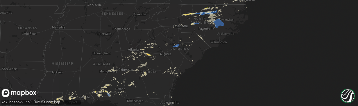
Hail Map in South Carolina on August 15, 2023
The weather event in South Carolina on August 15, 2023 includes Hail and Wind maps. 10 states and 444 cities were impacted and suffered possible damage. The total estimated number of properties impacted is 0.
Want more than just the map?
Turn this storm into a full workflow.
- Owner + property data so you know who to knock
- OnDemand branded weather history reports to win the "did we even have hail?" argument
- RoofTrace estimate so reps stop guessing numbers at the door
Bought this map? Upgrade within 7 days and we'll credit the $230. (10-15 min setup call)
Hail
Wind
0
Estimated number of impacted properties by a 1.00" hail or larger0
Estimated number of impacted properties by a 1.75" hail or larger0
Estimated number of impacted properties by a 2.50" hail or largerStorm reports in South Carolina
South Carolina
| Date | Description |
|---|---|
| 08/15/20235:24 PM CDT | The jasper county 911 call center reported a tree down near the intersection of coosaw scenic drive and roseland plantation drive. |
| 08/15/20235:09 PM CDT | The jasper county 911 call center reported power lines on fire due to fallen branches near the intersection of cotton hill road and cypress branch road. |
| 08/15/20234:50 PM CDT | Nws employee passed along a report from public of numerous trees downed in the emerald lakes subdivision. Time estimated by radar. |
| 08/15/20234:40 PM CDT | Corrects previous tstm wnd dmg report from 3 wnw oswego for report time. Nws employee passed along a report from public of numerous trees downed in the emerald lakes su |
| 08/15/20234:40 PM CDT | Sumter dot reports trees down on foxworth mill rd between hwy 15 and hwy 401. Time estimated from radar. |
| 08/15/20234:30 PM CDT | Sumter dot reports numerous trees down along queen chapel rd near dalzell. The dot cleared at least 10 large trees that fell on the roadway with additional tree damage |
| 08/15/20234:11 PM CDT | Tree snapped approximately 10 feet above base entirely blocking south charleston road near intersection with pocket road east of darlington... Sc. Time estimated based |
| 08/15/20234:08 PM CDT | Reported tree down along kershaw country club road. |
| 08/15/20234:02 PM CDT | Lancaster co dispatch reported trees down blocking the road at 672 w doc garris rd. Time estimated. |
| 08/15/20234:00 PM CDT | Lexington county em reported trees down on cedarcrest dr. At two notch rd. Time estimated by radar. |
| 08/15/20233:58 PM CDT | Reported trees down near sunday place road just of hwy. 200. |
| 08/15/20233:58 PM CDT | Lancaster co dispatch reported trees down blocking the road at 2893 bethel rd. Time estimated. |
| 08/15/20233:54 PM CDT | Reported trees down near the intersection of cedar creek road and mount carmel road. |
| 08/15/20233:50 PM CDT | Reported trees down near the intersection of green road and great falls highway... Hwy. 200. |
| 08/15/20233:45 PM CDT | Richland county reported a tree on a powerline and both are on fire on tanglewood rd. Time estimated by radar. |
| 08/15/20233:40 PM CDT | Richland county reported a tree down on the beltline village apartment complex. Time estimated by radar. |
| 08/15/20233:36 PM CDT | Photo on social media from possible spotter of large tree down on car on atascadero dr. In forest acres between timmerman school and the other store. Time estimated by |
| 08/15/20233:36 PM CDT | *** 2 inj *** corrects previous tstm wnd dmg report from forest acres. Photo on social media from possible spotter of large tree down on car on atascadero dr. In forest |
| 08/15/20233:31 PM CDT | Several trees down on 300 block of duke avenue... Columbia. |
| 08/15/20233:31 PM CDT | Columbia metro airport measured an 87 mph wind gust. |
| 08/15/20233:30 PM CDT | Lexington em reported trees down on continental dr. With debris in the road. Time estimated by radar. |
| 08/15/20233:30 PM CDT | Lexington county em reported a tree down over the road on corley mill rd. Time estimated by radar. |
| 08/15/20233:30 PM CDT | Lexington county em reported trees down on blackbird dr. Time estimated by radar. |
| 08/15/20233:30 PM CDT | Tree snapped approximately 10 feet above base blocking south charleston road near intersection with pocket road east of darlington... Sc. Other large trees uprooted nea |
| 08/15/20233:30 PM CDT | Corrects previous tstm wnd dmg report from 2 se lexington for correct time. Lexington county em reported trees down on cedarcrest dr. At two notch rd. Time estimated by |
| 08/15/20233:25 PM CDT | County reports multiple trees blown down from chester east to great falls. |
| 08/15/20233:07 PM CDT | Tree in road on hogarth street. |
| 08/15/20233:06 PM CDT | County emergency manager reported a power line down along mt. Pleasant road. |
| 08/15/20233:05 PM CDT | Corrects previous non-tstm wnd dmg report from 5 sw clover. 911 call center reported tree blocking roadway near the intersection of beersheba rd and templeton rd. |
| 08/15/20233:02 PM CDT | Tree in road near fording island road and malphrus road. |
| 08/15/20232:51 PM CDT | Saluda co dispatch reported numerous trees down over a widespread area... Generally in and near old town rd and hollywood rd. Time estimated. |
| 08/15/20232:45 PM CDT | Emergency manager reported several trees down over the county from near the fruit hill community to the town of saluda. Time estimated. |
| 08/15/20232:40 PM CDT | The lake wind site at the lake wateree dam reported a wind gust of 75 mph at 340 pm. |
| 08/15/20232:35 PM CDT | Public reported very strong winds at his residence which bent his flag pole in half. Time estimated by radar. |
| 08/15/20232:20 PM CDT | Duke energy reports trees blown down on powerlines near the intersection of golf course rd and louden rd. |
| 08/15/20232:00 PM CDT | Mccormick dispatch reported strong winds knocking at tree down at the mims community center. Time estimated by radar. |
| 08/15/20231:56 PM CDT | Tree downed along hwy 28. |
| 08/15/20231:48 PM CDT | One tree across highway 28 near the county line. |
| 08/15/20231:30 PM CDT | 5 trees reported down in and around calhoun falls. |
All States Impacted by Hail Map on August 15, 2023
Cities Impacted by Hail Map on August 15, 2023
- Timberlake, NC
- Commerce, GA
- Maysville, GA
- Nicholson, GA
- Athens, GA
- Hull, GA
- Loganville, GA
- Covington, GA
- Oxford, GA
- Crawfordville, FL
- Sopchoppy, FL
- Lawtey, FL
- Danielsville, GA
- Comer, GA
- Colbert, GA
- Rougemont, NC
- Mocksville, NC
- Advance, NC
- Oxford, NC
- Lexington, NC
- Winston Salem, NC
- High Point, NC
- Henderson, NC
- Thomasville, NC
- Greensboro, NC
- Jamestown, NC
- Pleasant Garden, NC
- Julian, NC
- Whitsett, NC
- Burlington, NC
- Liberty, NC
- Snow Camp, NC
- Graham, NC
- Haw River, NC
- Mebane, NC
- Chapel Hill, NC
- Efland, NC
- Hillsborough, NC
- Durham, NC
- Creedmoor, NC
- Wake Forest, NC
- Raleigh, NC
- Franklinton, NC
- Youngsville, NC
- Madison, GA
- Buckhead, GA
- Eatonton, GA
- Greensboro, GA
- White Plains, GA
- Sparta, GA
- Louisburg, NC
- Spring Hope, NC
- Gilbert, SC
- Lexington, SC
- West Columbia, SC
- Cayce, SC
- Columbia, SC
- Castalia, NC
- Troy, NC
- Biscoe, NC
- Star, NC
- Eagle Springs, NC
- Carthage, NC
- Robbins, NC
- Clio, SC
- McColl, SC
- Maxton, NC
- Little Rock, SC
- Laurinburg, NC
- Chesapeake, VA
- Benson, NC
- Four Oaks, NC
- Bush, LA
- Middlesex, NC
- Bailey, NC
- Cerro Gordo, NC
- Fair Bluff, NC
- Nichols, SC
- Pansey, AL
- Gordon, AL
- Shorter, AL
- Warthen, GA
- Ponchatoula, LA
- Mansfield, GA
- Rutledge, GA
- Seaboard, NC
- Pleasant Hill, NC
- Margarettsville, NC
- Monticello, GA
- Hampton, GA
- Du Pont, GA
- Pearl River, LA
- Hebron, MD
- Quantico, MD
- Tyaskin, MD
- Perkinston, MS
- Saucier, MS
- McHenry, MS
- Picayune, MS
- Carriere, MS
- Gulfport, MS
- Miami, FL
- Social Circle, GA
- Monroe, GA
- Griffin, GA
- Jackson, GA
- Samson, AL
- Suffolk, VA
- Carrsville, VA
- Windsor, VA
- Dunn, NC
- Goose Creek, SC
- Littleton, NC
- Kittrell, NC
- Branchville, VA
- Williamson, GA
- Concord, GA
- Zebulon, GA
- Bishop, GA
- Bogart, GA
- Watkinsville, GA
- Newborn, GA
- Salisbury, MD
- Jeanerette, LA
- Franklin, LA
- Clio, AL
- Ariton, AL
- Jacksonville, FL
- Orange Park, FL
- Wiggins, MS
- Lexington, GA
- Opp, AL
- Elba, AL
- Brantley, AL
- Roberta, GA
- Baconton, GA
- Camilla, GA
- Ozark, AL
- Fort Rucker, AL
- Hogansville, GA
- Franklin, GA
- Elberton, GA
- Georgetown, GA
- Bluffton, SC
- Cochran, GA
- Chester, GA
- Covington, LA
- Abita Springs, LA
- Reynolds, GA
- Rupert, GA
- Ellaville, GA
- Ideal, GA
- Hastings, FL
- Chester, SC
- Emporia, VA
- Charlotte, NC
- Atlanta, GA
- Jonesboro, GA
- Riverdale, GA
- Fairburn, GA
- Fayetteville, GA
- Union City, GA
- Denton, NC
- Defuniak Springs, FL
- Florala, AL
- Franklin, VA
- Graceville, FL
- Carlton, GA
- Zebulon, NC
- Madison, FL
- Mcdonough, GA
- Ocala, FL
- Marianna, FL
- Leary, GA
- Troy, AL
- Hamer, SC
- Newberry, SC
- Pomaria, SC
- Whitakers, NC
- Enfield, NC
- Nashville, NC
- Hollister, NC
- Mandeville, LA
- La Place, LA
- Bowman, GA
- Dewy Rose, GA
- Gastonia, NC
- Gay, GA
- Senoia, GA
- Elm City, NC
- Rocky Mount, NC
- Rowland, NC
- Newnan, GA
- Moreland, GA
- Macon, NC
- Brooklyn, MS
- Ridgeway, SC
- Good Hope, GA
- Rembert, SC
- Lugoff, SC
- Eastover, SC
- Hartford, AL
- Black, AL
- Dillon, SC
- Sandersville, GA
- Warrenton, NC
- Madisonville, LA
- Macon, GA
- Dry Branch, GA
- Bonifay, FL
- Dozier, AL
- Butner, NC
- Stockbridge, GA
- Chappells, SC
- Saluda, SC
- Ninety Six, SC
- Pike Road, AL
- Montgomery, AL
- Wilson, NC
- Banks, AL
- Brooks, GA
- Dawson, GA
- Lake View, SC
- Fairmont, NC
- Jacksonville Beach, FL
- Neptune Beach, FL
- Atlantic Beach, FL
- Auburn, AL
- Notasulga, AL
- Biloxi, MS
- Arlington, GA
- Morgan, GA
- Shellman, GA
- Folsom, LA
- Delmar, MD
- Laurel Hill, FL
- Mount Gilead, NC
- Slocomb, AL
- Saint Augustine, FL
- Wendell, NC
- Arnoldsville, GA
- Winterville, GA
- Fort Valley, GA
- Fernandina Beach, FL
- Yulee, FL
- Greenville, GA
- Coats, NC
- Candor, NC
- Harrisburg, NC
- Stennis Space Center, MS
- Buena Vista, GA
- Tallassee, AL
- Summerville, SC
- Shorterville, AL
- Abbeville, AL
- Staley, NC
- Darlington, SC
- Fargo, GA
- Pittsview, AL
- Sharpsburg, GA
- Newton, GA
- Reddick, FL
- Andalusia, AL
- Red Level, AL
- Angier, NC
- Clayton, NC
- Selma, NC
- Willow Spring, NC
- Smithfield, NC
- Garner, NC
- Hamilton, GA
- Bogalusa, LA
- Lacombe, LA
- Pacolet, SC
- Spartanburg, SC
- Randleman, NC
- Franklinville, NC
- Grand Ridge, FL
- Virginia Beach, VA
- Fort Gaines, GA
- Salisbury, NC
- Mobile, AL
- Clemmons, NC
- McLeansville, NC
- Vancleave, MS
- Fuquay Varina, NC
- Lagrange, GA
- Holly Springs, NC
- New Hill, NC
- Okatie, SC
- Hilton Head Island, SC
- Cedar Grove, NC
- Rayle, GA
- Crawford, GA
- Tuskegee, AL
- Nanticoke, MD
- Bivalve, MD
- Delmar, DE
- Hardaway, AL
- Tuskegee Institute, AL
- Eclectic, AL
- Butler, GA
- Poplarville, MS
- Hawkinsville, GA
- Edgefield, SC
- Blacksburg, SC
- Johnston, SC
- Trenton, SC
- Newton Grove, NC
- Corolla, NC
- Eight Mile, AL
- McLain, MS
- Byron, GA
- Jeffersonville, GA
- Gordon, GA
- Warner Robins, GA
- Lizella, GA
- Hurdle Mills, NC
- Mitchell, GA
- Fort Benning, GA
- Cusseta, GA
- Campbellton, FL
- Cottonwood, AL
- Peachtree City, GA
- Grantville, GA
- Weldon, NC
- Lumberton, MS
- Damascus, GA
- Hartsville, SC
- Roxboro, NC
- Calhoun Falls, SC
- Lucedale, MS
- Statesville, NC
- Harmony, NC
- Rolesville, NC
- Knightdale, NC
- Cary, NC
- Bunn, NC
- Cottondale, FL
- Albany, GA
- Princeton, NC
- Pine Level, NC
- Goldsboro, NC
- Mount Olive, NC
- Dudley, NC
- Faison, NC
- Calypso, NC
- Seven Springs, NC
- La Grange, NC
- Kinston, NC
- Snow Hill, NC
- Hookerton, NC
- Pikeville, NC
- Stantonsburg, NC
- Grifton, NC
- Fremont, NC
- Black Creek, NC
- Lucama, NC
- Kenly, NC
- Lockhart, AL
- Sumter, SC
- Dalzell, SC
- Semmes, AL
- Cut Off, LA
- Galliano, LA
- Atmore, AL
- Century, FL
- Flomaton, AL
- Erath, LA
- Holt, FL
- Vienna, GA
- Cordele, GA
- Hardeeville, SC
- Collins, GA
- Sylvania, GA
- Milton, FL
- Pinetops, NC
- Wing, AL
- Springfield, LA
- Maurepas, LA
- Jay, FL
- Mardela Springs, MD
- Mims, FL
- Brooklet, GA
- Oglethorpe, GA
- Larose, LA
- Lockport, LA
- Christmas, FL
- Crapo, MD
- Church Creek, MD
- Livingston, LA
- Brewton, AL
- Enterprise, AL
- Bay Minette, AL
- Statesboro, GA
- Moss Point, MS
- Ellabell, GA
- Timmonsville, SC
- McDavid, FL
- Lynchburg, SC
- Port Wentworth, GA
- Savannah, GA
- Daphne, AL
- Pineview, GA
- Kenner, LA
- Norlina, NC
- Kite, GA
- Geneva, FL
- Oviedo, FL
- Rochelle, GA
- Baker, FL
- Castleberry, AL
- Evergreen, AL
- Unadilla, GA
- Pinehurst, GA
- Raceland, LA
- Gheens, LA
- Gantt, AL
- Marshallville, GA
- Edison, GA
- Guyton, GA
- Bloomingdale, GA
- Clyo, GA
- Estill, SC
- Garnett, SC
- Pineland, SC
- Skipperville, AL
- Hertford, NC
- Osteen, FL
- Newington, GA
- Lamont, FL
- Pembroke, GA
- Register, GA
- Metter, GA
- Lamar, SC
- Monticello, FL
- Springfield, GA
- Rincon, GA
- Warrenton, GA
- New Smyrna Beach, FL
- Claxton, GA
- Cobbtown, GA
- Valdosta, GA
- Westville, FL


