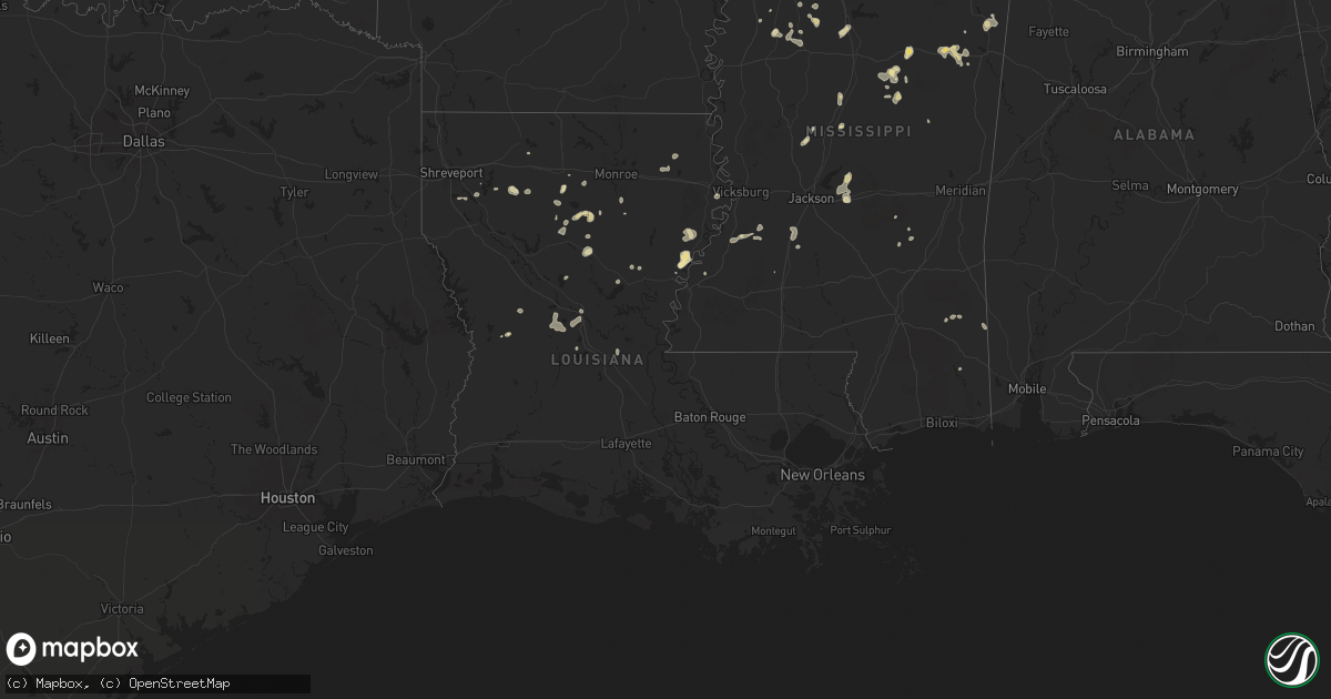
Hail Map in Louisiana on August 14, 2025
Get this storm
August 14 map
$229
one time, instant access
Download today. No call, no setup
Keep the $229
Bought the map and want the full workflow? Apply the entire $229 to a subscription within 7 days. None of it is wasted.
Every map, not just this one
This buys you this map. Subscription and you get every map we run, in the markets you choose from a few cities to whole states to nationwide. Plus real-time alerts the moment a storm fires.
Contact data
Name, contact info, occupancy, even credit band for addresses in the footprint. You go from where it hit to who to call.
Become the source they trust
Unlimited branding weather history reports on demand. You already have the documented answer ready for the property owner, and you are the one who showed up with it.
Property data and RoofTrace estimates
Pull up any address you have got, its value and the exact code rules for that jurisdiction, straight from One Click Code. Then RoofTrace estimates the squares, pitch, and roof value, priced the way you price.
Storm reports in Louisiana
Louisiana
| Date | Description |
|---|---|
| 08/14/20253:00 PM CDT | A tree was blown down across a power line along highway 154 near branch loop road. |
| 08/14/20251:49 PM CDT | A large tree was downed near the intersection of state routes 128 and 568. |
| 08/14/20251:40 PM CDT | [landspout] picture received via social media of a landspout off us 65 between oak grove and lake providence. |
All States Impacted by Hail Map on August 14, 2025
Cities Impacted by Hail Map on August 14, 2025
- Eros, LA
- Choudrant, LA
- Calhoun, LA
- Saint Joseph, LA
- Ayden, NC
- Hollis Center, ME
- Harrisonburg, LA
- Jonesville, LA
- Tallulah, LA
- Clayton, LA
- Waterproof, LA
- Buxton, ME
- Ferriday, LA
- Canby, MN
- Natchez, MS
- Ruston, LA
- Quitman, LA
- Port Gibson, MS
- Monroe, LA
- Baltimore, MD
- Towson, MD
- Pikesville, MD
- Parkville, MD
- Nottingham, MD
- Columbia, LA
- Louin, MS
- Madison, MN
- Lutherville Timonium, MD
- Hermanville, MS
- Prescott, AZ
- Springfield, ME
- Raleigh, MS
- Jena, LA
- Dawson, MN
- Boyd, MN
- Gibsland, LA
- Jamestown, LA
- Cherryfield, ME
- Danforth, ME
- Bay Springs, MS
- Rayville, LA
- Grayson, LA
- Hopkinsville, KY
- Utica, MS
- Chatham, LA
- Delhi, LA
- Sikes, LA
- Wesson, MS
- Quitman, GA
- Pelahatchie, MS
- Brandon, MS
- Crystal Springs, MS
- Bienville, LA
- Epps, LA
- Pioneer, LA
- Benton, MS
- Dewey, AZ
- Hazlehurst, MS
- Jonesboro, LA
- Cottonwood, AZ
- Bentonia, MS
- Vaughan, MS
- Dixie, GA
- Montevideo, MN
- Lena, MS
- Porter, MN
- Tullos, LA
- Dodson, LA
- Port Orange, FL
- Daytona Beach, FL
- Ringgold, LA
- Heflin, LA
- Greenville, FL
- Portsmouth, NH
- Kittery, ME
- Eliot, ME
- Rye, NH
- New Castle, NH
- Kittery Point, ME
- Tichnor, AR
- Leakesville, MS
- Minneota, MN
- Elm Grove, LA
- Ash Fork, AZ
- Olla, LA
- New Smyrna Beach, FL
- Winnfield, LA
- Sallis, MS
- Goodman, MS
- De Witt, AR
- Shreveport, LA
- Frierson, LA
- Hamburg, AR
- Clarkfield, MN
- Watson, MN
- Athens, LA
- Richton, MS
- Boyce, LA
- Crossett, AR
- Olive Branch, MS
- Durant, MS
- Taunton, MN
- Haughton, LA
- Noxapater, MS
- Philadelphia, MS
- Camp Verde, AZ
- Memphis, TN
- Dry Prong, LA
- Hermitage, AR
- El Dorado, AR
- Forest Hill, LA
- Carrollton, MS
- McCarley, MS
- Hanley Falls, MN
- Pineville, LA
- Alexandria, LA
- West, MS
- Orlando, FL
- Cascilla, MS
- Oviedo, FL
- Geneva, FL
- Cleveland, MS
- Hornsby, TN
- Grenada, MS
- French Camp, MS
- Charleston, MS
- Weir, MS
- Ethel, MS
- McCool, MS
- Cottonport, LA
- Bunkie, LA
- Holcomb, MS
- Pocahontas, TN
- Wellborn, FL
- Lake City, FL
- Elmer, LA
- Middleton, TN
- Starkville, MS
- Columbus, MS
- Tutwiler, MS
- Marshall, MN
- Cottonwood, MN
- Otis, LA
- Mattapan, MA
- Hyde Park, MA
- Dorchester Center, MA
- Roslindale, MA
- Jamaica Plain, MA
- Dorchester, MA
- Milton, MA
- Roxbury, MA
- Chestnut Hill, MA
- Briggsdale, CO
- Matheson, CO
- Limon, CO
- Ghent, MN
- Quincy, MA
- Kilmichael, MS
- Randolph, MA
- Braintree, MA
- Eupora, MS
- Weymouth, MA
- North Weymouth, MA
- Ackerman, MS
- Lucedale, MS
- Canton, MA
- Brookline, MA
- East Weymouth, MA
- Vance, MS
- Lambert, MS
- Mathiston, MS
- Drew, MS
- Kissimmee, FL
- Orchard, CO
- Dundee, FL
- West Point, MS
- Holbrook, MA
- South Weymouth, MA
- Saulsbury, TN
- Avon, MA
- Brockton, MA
- Abington, MA
- Stoughton, MA
- Hamilton, MS
- Philipp, MS
- Whitman, MA
- Walnut, MS
- Leesville, LA
- Rockland, MA
- East Bridgewater, MA
- Hanson, MA
- Hingham, MA
- Jasper, TX
- Colmesneil, TX
- Fort Morgan, CO
- Lynd, MN
- Haines City, FL
- Sugar City, CO
- Snyder, CO
- Rush, CO
- Caledonia, MS
- Aberdeen, MS
- Doddsville, MS
- Ruleville, MS
- Ashland, MS
- Minter City, MS
- Wiggins, CO
- Hugo, CO
- Wiergate, TX
- Karval, CO
- Greenwood, MS
- Shannon, MS
- Schlater, MS
- Sells, AZ
- Forest River, ND
- Minto, ND
- Ramah, CO
- Brookeland, TX
- West Bridgewater, MA
- Bridgewater, MA
- Hanover, MA
- Alliance, NE
- West Roxbury, MA
- East Grand Forks, MN
- Oslo, MN
- Warren, MN
- Euclid, MN
- Hay Springs, NE
- Cope, CO
- Rushville, NE
- Akron, CO
- Red Lake Falls, MN
- Badger, MN
- Pine Ridge, SD
- Thief River Falls, MN
- Otis, CO
- Yuma, CO
- Gordon, NE
- Morristown, AZ
- Plummer, MN
- Peoria, AZ
- Brooks, MN
- Oklee, MN
- Trail, MN
- Congress, AZ
- Ashley, ND
- Dupree, SD
- Isabel, SD
- Timber Lake, SD
- Eagle Butte, SD
- Strasburg, ND
- Agar, SD
- Selby, SD
- Bowdle, SD
- Java, SD
- Hoven, SD
- Fredonia, ND
- Leola, SD
- Eureka, SD
- Hosmer, SD
- Roscoe, SD
- Forbes, ND
- Gackle, ND
- Kulm, ND
- Long Lake, SD
- Hague, ND
- Ipswich, SD
- Frederick, SD
- Ellendale, ND
- Oakland, IA
- Hancock, IA
- Aberdeen, SD
- Hecla, SD
- Oakes, ND
- Westport, SD
- Kintyre, ND
- Columbia, SD
- Bath, SD
- Groton, SD
- Britton, SD
- Amherst, SD
- Langford, SD
- Claremont, SD
- Lake City, SD
- Saint Hilaire, MN


