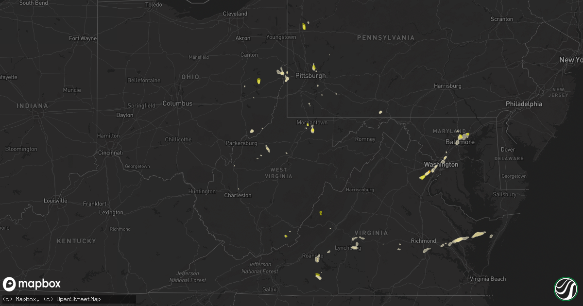
Hail Map in West Virginia on August 13, 2018
Get this storm
August 13 map
$229
one time, instant access
Download today. No call, no setup
Keep the $229
Bought the map and want the full workflow? Apply the entire $229 to a subscription within 7 days. None of it is wasted.
Every map, not just this one
This buys you this map. Subscription and you get every map we run, in the markets you choose from a few cities to whole states to nationwide. Plus real-time alerts the moment a storm fires.
Contact data
Name, contact info, occupancy, even credit band for addresses in the footprint. You go from where it hit to who to call.
Become the source they trust
Unlimited branding weather history reports on demand. You already have the documented answer ready for the property owner, and you are the one who showed up with it.
Property data and RoofTrace estimates
Pull up any address you have got, its value and the exact code rules for that jurisdiction, straight from One Click Code. Then RoofTrace estimates the squares, pitch, and roof value, priced the way you price.
Storm reports in West Virginia
West Virginia
| Date | Description |
|---|---|
| 08/13/20183:30 PM CDT | Hail fell at utc aerospace systems. |
| 08/13/20182:58 PM CDT | Trees down |
| 08/13/20182:50 PM CDT | Trees snapped and/or uprooted. |
| 08/13/20182:39 PM CDT | Tree down on mayhew rd |
| 08/12/201811:17 PM CDT | At 417 PM EDT, severe thunderstorms were located along a line extending from Vesuvius to near Lexington to near Natural Well, moving southeast at 20 mph. HAZARD...60 mph wind gusts and quarter size hail. SOURCE...Radar indicated. IMPACT...Hail damage to vehicles is expected. Expect wind damage to roofs, siding, and trees. Locations impacted include... Lynchburg... Lexington... Buena Vista... Covington... and Clifton Forge.This includes The following Location VMI. |
| 08/12/201810:49 PM CDT | At 348 PM EDT, a severe thunderstorm was located near Newburg, or 9 miles northeast of Grafton, moving south at 25 mph. HAZARD...60 mph wind gusts and quarter size hail. SOURCE...Radar indicated. IMPACT...Hail damage to vehicles is expected. Expect wind damage to roofs, siding, and trees. Locations impacted include... Grafton, Philippi, Moatsville, Tygart Lake State Park, Thornton, Knottsville and Nestorville. |
| 08/12/201810:45 PM CDT | At 345 PM EDT, a severe thunderstorm was located near Newburg, or 11 miles northeast of Grafton, moving southeast at 10 mph. HAZARD...Wind gusts to 60 mph and quarter-size hail. SOURCE...Radar. IMPACT...Hail damage to vehicles. Damage to trees and power lines. Locations impacted include... Rowlesburg... Newburg... Brookhaven... Reedsville... Masontown... Tunnelton... Gladesville... Browns Chapel...This includes the following highways... Interstate 68 in West Virginia between mile markers 2 and 4. Interstate 79 in West Virginia between mile markers 146 and 147. |
| 08/12/20189:49 PM CDT | At 249 PM EDT, a severe thunderstorm was located over Wallback, or 7 miles northwest of Clay, moving southeast at 10 mph. HAZARD...60 mph wind gusts and quarter size hail. SOURCE...Radar indicated. IMPACT...Hail damage to vehicles is expected. Expect wind damage to roofs, siding, and trees. Locations impacted include... Clay, Big Otter, Wallback, Nebo, Ivydale, Chloe and Procious. This includes Interstate 79 between mile markers 29 and 43. |
All States Impacted by Hail Map on August 13, 2018
Cities Impacted by Hail Map on August 13, 2018
- Nottingham, MD
- Parkville, MD
- Towson, MD
- Baltimore, MD
- College Park, MD
- Tucumcari, NM
- Conchas Dam, NM
- Burke, VA
- Fairfax Station, VA
- Patterson, GA
- Shattuck, OK
- Solano, NM
- Mosquero, NM
- New Cumberland, WV
- Georgetown, PA
- Burgettstown, PA
- Colliers, WV
- Weirton, WV
- Valdosta, GA
- Ludowici, GA
- Manassas, VA
- Clifton, VA
- Woodbridge, VA
- Concord, VA
- Lynchburg, VA
- Amelia Court House, VA
- Coxs Mills, WV
- Auburn, WV
- Camp Verde, AZ
- Alden, MN
- Albert Lea, MN
- Hartland, MN
- Gate, OK
- Tallahassee, FL
- New Smyrna Beach, FL
- Snowflake, AZ
- Kittanning, PA
- San Jose, NM
- Las Vegas, NM
- Plains, KS
- Marietta, OH
- Vinton, VA
- Roanoke, VA
- Hardy, VA
- Goodview, VA
- Doerun, GA
- Moultrie, GA
- Albany, GA
- Roy, NM
- Pittsburgh, PA
- Gibsonia, PA
- Cheswick, PA
- Glenshaw, PA
- Allison Park, PA
- Sanborn, ND
- Cumberland, VA
- Meade, KS
- Fowler, KS
- Sedona, AZ
- Rimrock, AZ
- Show Low, AZ
- Mercer, PA
- Jackson Center, PA
- Grove City, PA
- Painter, VA
- Belle Haven, VA
- Hacksneck, VA
- Clearville, PA
- Flagstaff, AZ
- Harkers Island, NC
- Baconton, GA
- Newton, GA
- Morgantown, WV
- Independence, WV
- Wolverton, MN
- Brentwood, MD
- Hyattsville, MD
- Mount Rainier, MD
- Washington, DC
- Rocky Mount, VA
- Saluda, VA
- Shacklefords, VA
- Gloucester, VA
- Adel, GA
- Springfield, VA
- Milnor, ND
- Ronceverte, WV
- Nokesville, VA
- Copeland, KS
- Montezuma, KS
- Toronto, OH
- Appomattox, VA
- Gladstone, VA
- Madison Heights, VA
- Follansbee, WV
- Reno, OH
- Whipple, OH
- Mcalister, NM
- House, NM
- Martinsville, VA
- Penhook, VA
- Harrisville, WV
- Pullman, WV
- Pennsboro, WV
- Berea, WV
- Acme, PA
- Stahlstown, PA
- Detroit Lakes, MN
- White Stone, VA
- Saint Johns, AZ
- Sanford, FL
- Sandy Lake, PA
- Polk, PA
- Breckenridge, MN
- Cushing, MN
- Hinesville, GA
- Blackshear, GA
- Nahunta, GA
- Greenbelt, MD
- Beltsville, MD
- Grafton, WV
- Fairmont, WV
- Kingsville, MD
- Catonsville, MD
- Upper Falls, MD
- Glen Arm, MD
- Middle River, MD
- Rosedale, MD
- White Marsh, MD
- Lutherville Timonium, MD
- Perry Hall, MD
- Halethorpe, MD
- Newcomerstown, OH
- Port Washington, OH
- Springerville, AZ
- Waycross, GA
- Randall, MN
- Rices Landing, PA
- Carmichaels, PA
- Cockeysville, MD
- Falls Church, VA
- Arlington, VA
- Alexandria, VA
- Midway, GA
- Amherst, VA
- Quaker City, OH
- Richmond Hill, GA
- Sylvester, GA
- Marshallberg, NC
- Verona, PA
- Oakmont, PA
- Lake Park, GA
- Celeste, TX
- Douglas, GA
- Seligman, AZ
- Laverne, OK
- Irondale, OH
- Artemas, PA
- Hartfield, VA
- Barhamsville, VA
- Mattaponi, VA
- Locust Hill, VA
- Wake, VA
- West Point, VA
- Topping, VA
- Mayer, AZ
- Fingal, ND
- Enderlin, ND
- Nome, ND
- Bristol, GA
- Mershon, GA
- Glade Hill, VA
- Rozet, WY
- Providence Forge, VA
- Rivesville, WV
- Cadiz, OH
- Scio, OH
- Audubon, MN
- East Millsboro, PA
- Clarksville, PA
- Hortense, GA
- Annandale, VA
- Cimarron, KS
- Burtonsville, MD
- Laurel, MD
- New Matamoras, OH
- Forgan, OK
- Ripley, WV
- Sandyville, WV
- Wallace, NC
- Allenhurst, GA
- Empire, OH
- Stratton, OH
- Sunray, TX
- Dumas, TX
- Sumner, GA
- Valley City, ND
- Bedford, VA
- Perryopolis, PA
- Dawson, PA
- Charleston, WV
- Henrico, VA
- Chester, VA
- Colonial Heights, VA
- Richmond, VA
- Fort Towson, OK
- Big Bend, WV
- Oriska, ND
- Gallup, NM
- Sutersville, PA
- Elizabeth, PA
- Concho, AZ
- Weston, WV
- Camden, WV
- Thomasville, GA
- Lenox, GA
- Sparks, GA
- Wheatland, ND
- Norman Park, GA
- Osage, MN
- Park Rapids, MN
- Lexington, VA
- Valliant, OK
- Lanexa, VA
- Beaver, OK
- Fleming, GA
- Sinks Grove, WV
- Union, WV
- Big Springs, WV
- Smithville, WV
- Ashdown, AR
- Indianola, PA
- Stoneboro, PA
- Bowerston, OH
- Millboro, VA
- Quantico, VA


