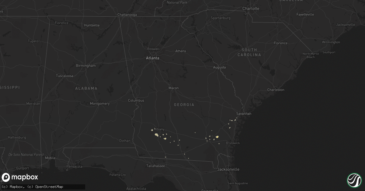
Hail Map in Georgia on August 13, 2018
Get this storm
August 13 map
$229
one time, instant access
Download today. No call, no setup
Keep the $229
Bought the map and want the full workflow? Apply the entire $229 to a subscription within 7 days. None of it is wasted.
Every map, not just this one
This buys you this map. Subscription and you get every map we run, in the markets you choose from a few cities to whole states to nationwide. Plus real-time alerts the moment a storm fires.
Contact data
Name, contact info, occupancy, even credit band for addresses in the footprint. You go from where it hit to who to call.
Become the source they trust
Unlimited branding weather history reports on demand. You already have the documented answer ready for the property owner, and you are the one who showed up with it.
Property data and RoofTrace estimates
Pull up any address you have got, its value and the exact code rules for that jurisdiction, straight from One Click Code. Then RoofTrace estimates the squares, pitch, and roof value, priced the way you price.
Storm reports in Georgia
Georgia
| Date | Description |
|---|---|
| 08/13/20186:40 PM CDT | Tree down across stage coach road just south of vines road. |
| 08/13/20182:35 PM CDT | Warning point reported powerlines down on sandy run road. |
| 08/13/20182:35 PM CDT | Warning point reported tree down at thompson road and griffin road. |
| 08/13/20182:34 PM CDT | Warning point reported tree down at highway 84 and old sunbury road. |
| 08/13/20181:04 PM CDT | Two trees down reported in richmond hill. One small tree fell on car in richmond hill library parking lot. No one was in the car. The second tree was uprooted in the wh |
| 08/13/20182:25 AM CDT | At 725 PM EDT, a severe thunderstorm was located over Baconton, or 8 miles southwest of Putney, moving east at 15 mph. HAZARD...60 mph wind gusts. SOURCE...Radar indicated. IMPACT...Expect damage to roofs, siding, and trees. Locations impacted include... Newton, Putney, Camilla, Baconton, Doerun, Sale City, Bridgeboro, Flint, Parkerville, Lester, Pritchetts, Poplar Arbor Church, Crestwood, Williamsburg, Greenough, Red Store Crossroads, Livingston, Ticknor, Minnesota and Laney. |
| 08/12/201811:39 PM CDT | At 439 PM EDT, severe thunderstorms were located along a line extending from near Dixie Union to near Blackshear, and are nearly stationary. HAZARD...60 mph wind gusts and quarter size hail. SOURCE...Radar indicated. IMPACT...Hail damage to vehicles is expected. Expect wind damage to roofs, siding, and trees. Locations impacted include... Blackshear, Dixie Union and Jamestown. |
| 08/12/201811:15 PM CDT | At 415 PM EDT, severe thunderstorms were located along a line extending from 8 miles northeast of Raybon to near Blackshear, moving southeast at 10 mph. HAZARD...60 mph wind gusts and penny size hail. SOURCE...Radar indicated. IMPACT...Expect damage to roofs, siding, and trees. Locations impacted include... Patterson, Offerman, Raybon and Hortense. |
| 08/12/201811:08 PM CDT | At 408 PM EDT, severe thunderstorms were located along a line extending from 15 miles southeast of Richmond Hill to near Tibet, moving east at 15 mph. HAZARD...60 mph wind gusts and penny size hail. SOURCE...Radar indicated. IMPACT...Expect damage to trees and powerlines. Locations impacted include... Darien, Jones, Wolf Island, Harris Neck, St. Catherines Island, Eulonia, Valona and Little Saint Simons Island.This warning includes I-95 in Georgia between mile markers 50 and 71,and between mile markers 79 and 86. |
| 08/12/201810:29 PM CDT | At 329 PM EDT, severe thunderstorms were located along a line extending from Fort Stewart to near Ludowici, moving east at 15 mph. HAZARD...60 mph wind gusts and penny size hail. SOURCE...Radar indicated. IMPACT...Expect damage to trees and powerlines. Locations impacted include... Hinesville, Ludowici, Tibet, Fort Stewart, McIntosh, Walthourville, Midway and Riceboro.This warning includes I-95 in Georgia between mile markers 72 and 78. |
| 08/12/20189:43 PM CDT | At 243 PM EDT, a severe thunderstorm was located near Bristol, or 11 miles north of Patterson, and is nearly stationary. HAZARD...60 mph wind gusts. SOURCE...Radar indicated. IMPACT...Expect damage to roofs, siding, and trees. This severe thunderstorm will remain over mainly rural areas of north central Pierce...eastern Bacon...west central Wayne and southeastern Appling Counties. |
All States Impacted by Hail Map on August 13, 2018
Cities Impacted by Hail Map on August 13, 2018
- Nottingham, MD
- Parkville, MD
- Towson, MD
- Baltimore, MD
- College Park, MD
- Tucumcari, NM
- Conchas Dam, NM
- Burke, VA
- Fairfax Station, VA
- Patterson, GA
- Shattuck, OK
- Solano, NM
- Mosquero, NM
- New Cumberland, WV
- Georgetown, PA
- Burgettstown, PA
- Colliers, WV
- Weirton, WV
- Valdosta, GA
- Ludowici, GA
- Manassas, VA
- Clifton, VA
- Woodbridge, VA
- Concord, VA
- Lynchburg, VA
- Amelia Court House, VA
- Coxs Mills, WV
- Auburn, WV
- Camp Verde, AZ
- Alden, MN
- Albert Lea, MN
- Hartland, MN
- Gate, OK
- Tallahassee, FL
- New Smyrna Beach, FL
- Snowflake, AZ
- Kittanning, PA
- San Jose, NM
- Las Vegas, NM
- Plains, KS
- Marietta, OH
- Vinton, VA
- Roanoke, VA
- Hardy, VA
- Goodview, VA
- Doerun, GA
- Moultrie, GA
- Albany, GA
- Roy, NM
- Pittsburgh, PA
- Gibsonia, PA
- Cheswick, PA
- Glenshaw, PA
- Allison Park, PA
- Sanborn, ND
- Cumberland, VA
- Meade, KS
- Fowler, KS
- Sedona, AZ
- Rimrock, AZ
- Show Low, AZ
- Mercer, PA
- Jackson Center, PA
- Grove City, PA
- Painter, VA
- Belle Haven, VA
- Hacksneck, VA
- Clearville, PA
- Flagstaff, AZ
- Harkers Island, NC
- Baconton, GA
- Newton, GA
- Morgantown, WV
- Independence, WV
- Wolverton, MN
- Brentwood, MD
- Hyattsville, MD
- Mount Rainier, MD
- Washington, DC
- Rocky Mount, VA
- Saluda, VA
- Shacklefords, VA
- Gloucester, VA
- Adel, GA
- Springfield, VA
- Milnor, ND
- Ronceverte, WV
- Nokesville, VA
- Copeland, KS
- Montezuma, KS
- Toronto, OH
- Appomattox, VA
- Gladstone, VA
- Madison Heights, VA
- Follansbee, WV
- Reno, OH
- Whipple, OH
- Mcalister, NM
- House, NM
- Martinsville, VA
- Penhook, VA
- Harrisville, WV
- Pullman, WV
- Pennsboro, WV
- Berea, WV
- Acme, PA
- Stahlstown, PA
- Detroit Lakes, MN
- White Stone, VA
- Saint Johns, AZ
- Sanford, FL
- Sandy Lake, PA
- Polk, PA
- Breckenridge, MN
- Cushing, MN
- Hinesville, GA
- Blackshear, GA
- Nahunta, GA
- Greenbelt, MD
- Beltsville, MD
- Grafton, WV
- Fairmont, WV
- Kingsville, MD
- Catonsville, MD
- Upper Falls, MD
- Glen Arm, MD
- Middle River, MD
- Rosedale, MD
- White Marsh, MD
- Lutherville Timonium, MD
- Perry Hall, MD
- Halethorpe, MD
- Newcomerstown, OH
- Port Washington, OH
- Springerville, AZ
- Waycross, GA
- Randall, MN
- Rices Landing, PA
- Carmichaels, PA
- Cockeysville, MD
- Falls Church, VA
- Arlington, VA
- Alexandria, VA
- Midway, GA
- Amherst, VA
- Quaker City, OH
- Richmond Hill, GA
- Sylvester, GA
- Marshallberg, NC
- Verona, PA
- Oakmont, PA
- Lake Park, GA
- Celeste, TX
- Douglas, GA
- Seligman, AZ
- Laverne, OK
- Irondale, OH
- Artemas, PA
- Hartfield, VA
- Barhamsville, VA
- Mattaponi, VA
- Locust Hill, VA
- Wake, VA
- West Point, VA
- Topping, VA
- Mayer, AZ
- Fingal, ND
- Enderlin, ND
- Nome, ND
- Bristol, GA
- Mershon, GA
- Glade Hill, VA
- Rozet, WY
- Providence Forge, VA
- Rivesville, WV
- Cadiz, OH
- Scio, OH
- Audubon, MN
- East Millsboro, PA
- Clarksville, PA
- Hortense, GA
- Annandale, VA
- Cimarron, KS
- Burtonsville, MD
- Laurel, MD
- New Matamoras, OH
- Forgan, OK
- Ripley, WV
- Sandyville, WV
- Wallace, NC
- Allenhurst, GA
- Empire, OH
- Stratton, OH
- Sunray, TX
- Dumas, TX
- Sumner, GA
- Valley City, ND
- Bedford, VA
- Perryopolis, PA
- Dawson, PA
- Charleston, WV
- Henrico, VA
- Chester, VA
- Colonial Heights, VA
- Richmond, VA
- Fort Towson, OK
- Big Bend, WV
- Oriska, ND
- Gallup, NM
- Sutersville, PA
- Elizabeth, PA
- Concho, AZ
- Weston, WV
- Camden, WV
- Thomasville, GA
- Lenox, GA
- Sparks, GA
- Wheatland, ND
- Norman Park, GA
- Osage, MN
- Park Rapids, MN
- Lexington, VA
- Valliant, OK
- Lanexa, VA
- Beaver, OK
- Fleming, GA
- Sinks Grove, WV
- Union, WV
- Big Springs, WV
- Smithville, WV
- Ashdown, AR
- Indianola, PA
- Stoneboro, PA
- Bowerston, OH
- Millboro, VA
- Quantico, VA


